Transcription
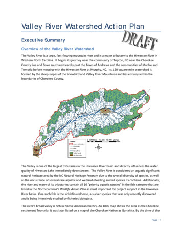
Valley River Watershed Action PlanExecutive SummaryOverview of the Valley River WatershedThe Valley River is a large, fast-flowing mountain river and is a major tributary to the Hiwassee River inWestern North Carolina. It begins its journey near the community of Topton, NC near the CherokeeCounty line and flows southwestwardly past the Town of Andrews and the communities of Marble andTomotla before merging with the Hiwassee River at Murphy, NC. Its 120-square mile watershed isformed by the steep slopes of the Snowbird and Valley River Mountains and lies entirely within theboundaries of Cherokee County.The Valley is one of the largest tributaries in the Hiwassee River basin and directly influences the waterquality of Hiwassee Lake immediately downstream. The Valley River is considered an aquatic significantnatural heritage area by the NC Natural Heritage Program due to the overall diversity of species, as wellas the occurrence of several rare aquatic and wetland-dwelling animal species its contains. Additionally,the river and many of its tributaries contain all 10 “priority aquatic species” in the fish category that arelisted in the North Carolina’s Wildlife Action Plan as most important for project support in the HiwasseeRiver basin. One such fish is the sicklefin redhorse, a sucker species that was only recently discoveredand is being intensively studied by fisheries biologists.The river’s broad valley is rich in Native American history. An 1805 map shows the area as the Cherokeesettlement Toonatla. It was later listed on a map of the Cherokee Nation as Gunahita. By the time of thePage 1
removal of the Cherokee Indians in 1838, it was known as Konehetee, or valley. One of the mostinfamous periods in history, the removal of the Cherokee and the Trail of Tears, heavily impacted thevalley.The largest town in the watershed is Andrews. In the early 1800s, when most white settlers beganarriving, the area was known as Jamesville, after James Whitaker. An Indian Trading Post wasestablished in 1837 and soon after the community was known as Valley Town. The present town wasestablished like many other southern towns, through a land auction.The official "Town of Murphy" was founded in 1835. On this date the first post office was opened underthe name of Huntington, with Col. H.R.S. Hunter the first Postmaster. Huntington later became Murphy,named after Archibald D. Murphey, father of the North Carolina Public School System. In 1839,Cherokee County was formed from a portion of neighboring Macon County. In 1851, Murphy wasincorporated as the county seat of Cherokee County.In 1922, the first paved road opened from Murphy to the Georgia line. In 1935 the Tennessee ValleyAuthority (TVA) authorized the construction of the Hiwassee Dam, which began later that year and wascompleted in 1940. The dam created a body of water covering nearly 6,090 acres, and was the highestoverspill type dam in the world at the time. The ever-changing level of Hiwassee Reservoir due tooperations at Hiwassee Dam influences the character of the lower end of the Valley River, even thoughthe confluence of the two rivers is severalmiles upstream of the dam.Today, an estimated 26,568 people live inCherokee County, NC. The county, and partsof the Valley River watershed, experienced arapid 17% growth rate between 1990 and2000. Between 2000 and 2008 CherokeeCounty population expanded at 9.4%compared to the statewide average of 14.6%and an explosive 18.4% in neighboring ClayCounty. The 4-lane US Highway 74/19/129 isthe major transportation route through thewatershed and closely parallels the riveritself. Most commercial, residential, andagricultural development is concentratedwithin 2 miles of this highway. Several otherroads are 2-lane asphalt corridors, but thereare also more than 160 miles of unpavedrural roads.South of the Town of Andrews (pictured top), 4-lane US 74/19/129 parallels the wooded Valley River corridor (picturedto the right of the highway).Page 2
Physical Characteristics of the River & WatershedThe Valley River watershed falls within the Broad Basins (characterized by lower elevations, less relief,less precipitation, and less forested cover) and the Southern Meta-sedimentary Mountains(characterized by steeper relief, more precipitation, and more forested area) physiographic regions. Thecommunity of Topton, at the northeast boundary of the watershed lies at an elevation of 2,638 feetabove sea level (ASL). Twenty miles downstream at the confluence of the Valley and Hiwassee Rivers,the Town of Murphy sits at 1,604 feet ASL.Forest covers nearly 100 square miles of thewatershed. Almost half of this forestlandlies within the boundaries of the NantahalaNational Forest and is thus consideredprotected. Roughly 6,000 acres (9 mi2) aredevoted to agricultural uses. Althoughmost of this is pastureland, roughly 800acres are devoted to row crops in thevalley, mostly corn and soybeans. Another5,000 acres (8 mi2) have been developed forcommercial, industrial, or residential uses.There are 631 miles of intermittent (365mi.) and perennial (266 mi.) streams in theValley River watershed. Perennial streams flow constantly except in periods of extreme drought.Intermittent streams have a clearly defined channel, but often stop flowing during dry spells. Thisaverages out to about 40 feet of stream collecting runoff from every acre in the watershed, andillustrates how human activities on each piece of land are directly connected to water quality in theValley River itself.Need for Valley River Restoration PlanSection 303(d) of the Clean Water Act (CWA) requires the North Carolina Division of Water Quality(DWQ) to develop a list of waters not meeting water quality standards or which have impaired uses.Listed waters must be prioritized, and a management strategy or total maximum daily load (TMDL) mustsubsequently be developed for all listed waters. The Valley River appears on the list because of turbidityviolations; however, a TMDL has not yet been developed by DWQ. Resource constraints and statewidepriorities may slow DWQ’s development of a TMDL. HRWC is developed this watershed action plan sothat known sources of excess sediment can be addressed and water quality improvement can proceedin a timely manner.In 2001, the Hiwassee River Watershed Coalition, Inc. (HRWC) began an intensive, holistic assessment ofthe watershed in preparation for restoration work. Very little current biological and habitat data wasavailable for the watershed at that time. HRWC brought together a partnership between themselves,DWQ, and TVA to reassess the condition of the watershed. The results of this study were published inPage 3
2004 and revealed chronic water quality and habitat impacts resulting from a lack of riparian vegetation,streambank erosion, livestock access, stream alterations, and runoff from highways and unpaved roads.Several long-term monitoring sites were sampled by DWQ in 2004 and a revised version of the HiwasseeRiver Basinwide Water Quality Plan was published. The plan discusses habitat degradation and turbidityviolations in the Valley River. It also reports an increase in the in-stream temperature of the river duelargely to a lack of adequate riparian vegetation along streams in the watershed. The Valley RiverWatershed Action Plan outlines a course of action to remediate these problems.Causes & Sources of DegradationThere are many causes and literally hundreds of site specific sources of degradation in the Valley Riverwatershed. A cumulative web of environmental torments cause the chronic habitat degradation andturbidity violations observed in the watershed. The parking lot at the grocery store, the trees andshrubs cleared away from the stream, and the cattle standing on the riverbank in a nearby pasture areall making small contributions to the problem. For example, stormwater runs off parking lots and otherimpervious surfaces much faster than it would off a forest floor. This fast moving water has a lot ofenergy and when it reaches a stream weakened by livestock access and without stable vegetation alongthe banks, the water goes to work eroding the streambanks. The eroded soil from the streambanksthen settles out as the water slows downstream and smothers fish spawning beds. In addition tohabitat loss, severe erosion problems can lead to actual loss of property and threaten buildings withcollapse.Most water quality and habitat degradation can be traced back to land use decisions made somedistance, even miles away from the stream itself. Rainwater carries debris and pollutants from everytype of surface it falls on weather that be a rooftop or rugged mountain slope. The volume ofstormwater and the speed at which it flows over the land also impacts water quality and habitatconditions. In an undisturbed environment, stormwater washes into streams gradually. Streams areable to absorb the water’s energy and resist erosion. These are stable streams. Streams becomeincreasingly unstable as natural forest cover is replaced by hard, impervious surfaces like parking lots,roads, and rooftops. Water runs off these surfaces much faster and erodes streambanks and channels.The eroded soil then smothers downstream aquatic habitat.Turbidity is one metric used to measure how severe erosion problems are. The State of North Carolinahas established turbidity standards to protect aquatic life. The standards define the highest allowablelevels of turbidity and are expressed in NTUs, or Nephelometric Turbidity Units. Turbidity may notexceed the state standard in more than 10% of measurements. The standard for most streams acrossthe state is 50 NTU, however it is only 10 NTU for classified trout waters. The stricter standardrecognizes the extreme sensitivity of cold water aquatic communities like those found in the Valley Riverand many of its tributaries to excess sediment and other impurities.DWQ takes monthly turbidity measurements in the Valley River at the US74/19/129 Bridge nearTomotla. A 5-year average is calculated from these measurements to determine if the standard is beingmet. The last such average was calculated in 2005 using data from 1999-2004. At that time, 12.2% ofPage 4
the readings taken from the Valley River exceeded the state turbidity standards. Therefore, 7.7 miles ofthe Valley River from Vengeance Creek to Marble Creek is Listed on the State’s 303(d) list of ImpairedWaters. Turbidity is the official cause of impairment.Summary of Causes & Sources Linked with Plan GoalThe primary goal of the Valley River Watershed Action Plan and ongoing restoration work in thewatershed is to reverse the water quality impairment due to turbidity violations and permanentlyremove the river from the NC 303(d) List of Impaired Waters. This will be achieved by addressing thesources mentioned above and achieving a set of supporting goals including streambank restoration,reducing stormwater impacts, strengthening community partnerships, and community education.The sources described above are broad categories that contribute to degradation in the Valley River.These general sources often produce the same symptoms of degradation within the stream. Forexample, excessive stormwater runoff and livestock access both cause stream bank erosion. To clarifyneeded actions, very specific stream degradation causes are linked with the sources described aboveand the management goals needed to eliminate them. This work is presented in Table A.Target Reductions & Watershed PrioritizationTurbidity violations are caused by excess sediment and erosion originating from a broad spectrum ofland use activities including unstable streambanks, unstable soils, eroding roads, impervious surfaces,etc. While turbidity and excess erosion are tightly linked, they are not the same. Therefore a methodmust be used to translate the quantity of land-based erosion to in-stream turbidity measurements sothat target reduction can be set.In 2004, HRWC invested in the Valley River IPSI Pollutant Loading Model (PLM) to provide immediatesupport for its ongoing restoration project. It is a desktop computer model that uses the data generatedby the GIS-based IPSI inventory to estimate pollutant loadings from selected watershed features likeroads, streambanks, and pasture. The model, designed to run using Microsoft Excel software, allowsHRWC to estimate pollutant loadings by watershed and source at varying delivery rates.HRWC used the PLM to develop a tenable link between the turbidity violations and the total suspendedsolid (TSS) load from the Valley River watershed. TSS is a weight measurement of loose soil and debriswashed into streams. The baseline scenario assumes that the current estimated TSS load caused theturbidity violations and led to impairment. In DWQ’s analysis, 12.2% of its measurements violated theturbidity standard. To reverse the impairment, turbidity violations must be brought below 10%. Thebaseline PLM estimates the TSS load in the Valley River watershed is 21,713.2 tons/year. In order todrop turbidity violations to 10%, the TSS load must be reduced to 17797.7 tons/year, or 22%.Once a total TSS load reduction value was reached, HRWC then used the PLM to determine which subwatersheds contribute the most TSS from human activities. By dividing TSS load by watershed acreage,HRWC determined which watersheds have the most concentrated impact. The results are presented inFigure A. Moderate to severely ranked watersheds are in most desperate need of restoration resources.Page 5
Table A. Summary of Management Objectives Identified for the Valley River WatershedCausesSourcesManagement ObjectivesExcess Sediment (Turbidity) &Decreased Aquatic Habitat Lack of adequate erosion control practicesimplemented and/or maintained duringconstruction Poor private access road construction1) Improve implementation of erosion/sedimentcontrol BMPs on construction sites within thewatershed.2) Provide seminars to educate people about propererosion/sediment control BMPs for construction3) Employ and equip personnel for adequateenforcement existing laws and rules pertaining towater quality protection at the local level.4) Provide seminars to educate people about properconstruction and maintenance of private accessroads in the mountain landscape Past and present damage to river banks and smallstream channels by unrestricted livestock accessand lack of adequate riparian buffers5) Restrict livestock access to streams by constructingfencing and providing alternative watering sources6) Repair damage to eroding stream banks andunstable channels using bioengineering and naturalchannel design techniques Overgrazing of pasture lands7) Rotate livestock and implement BMPs for winterfeeding as needed to prevent loss of vegetation andovergrazing. Erosion of stream banks associated with stormwaterimpacts and natural events (e.g. storms, floods)8) Reduce impervious surfaces to minimize impacts ofstorm events9) Install post-construction stormwater BMPs to helpretain and filter stormwater runoff Lack of adequate riparian buffers10) Restore and protect wooded riparian buffers. Damage to vegetation by livestock11) Prevent damage to riparian vegetation by livestock. Runoff from large amounts of impervious surfacesFailing septic systemsAgricultural runoff from field and pastureAging sewer system infrastructure & lack of nutrientremoval at wastewater treatment plants12)13)14)15)Increased TemperatureExcess nutrientsLimit imperviousness in the watershed.Identify and repair failing systemsInstall agricultural BMPsProactively repair sewer system infrastructure tominimize I&I problems and add nutrient removalsystems when WWTPs are renovated or expandedPage 6
Figure A. Loading of Total Suspended Solids by sub-watershed.Page 7
Recommended Actions for Watershed ImprovementRecommended actions are only listed in this section. Please visit the Hiwassee River watershedCoalition’s web site for a more detailed discussion of the recommendations: www.hrwc.net orcontact the HRWC office if you prefer to be mailed a hard copy.Federal and State Government6 Enforce applicable water quality rules and regulations and sediment/erosion control66666666lawsProvide increased monitoring stream monitoring, especially on lower elevation streams.Continue to provide basin-wide insight into watershed health on a regular basisMake implementation of this plan a top priority for funding programs.Provide assistance to local governments who are trying to manage growth (technology,training & funding)Provide an awareness of relevant tools as they become availableAvoid implementation of “blanket” rules and regulations and include Valley Riverwatershed residents and local governments early in any rule development process.Adopt this action plan in lieu of a TMDL and direct those resources that would havebeen consumed developing that TMDL towards implementation of this plan.Provide HRWC a reliable liaison from headquarter offices.Local Government666666Establish a local sediment/erosion control programEvaluate your own properties for potential BMPs to retain/treat stormwaterProvide funding for management measures outlined in this planConsider adopting a stormwater ordinancePlan for wastewater treatment for new development/increased populationConsider conducting a regional planning initiativeResidents66666666Educate yourself & others about the issuesReport erosion control problems to the appropriate authoritiesRestore and/or maintain a woody riparian buffer along streams on your propertyEvaluate your home site for ways to retain or treat stormwaterMinimize water usage and runoff at homeProperly maintain your septic tankEncourage businesses that you patronize to implement stormwater BMPsSupport your local governments in their efforts to implement water quality protectionmeasures6 Support HRWC by volunteering or through donations.6 Assist HRWC in operating a volunteer monitoring program in the Valley River.Page 8
Developer/Builders/Grading-Clearing Contractors6 Educate yourself and co-workers/staff about erosion control and stormwater issues6 Design roads to follow natural contours of the land and such that no slopes are greater6666666than 15% gradePlace home sites in locations that minimize earthworkDesign developments and home sites with stormwater and water quality in mind(minimize impervious surfaces & protect sensitive areas)Avoid creating cut/fill slopes that are greater than 1.5H:1VRestore/maintain woody riparian buffers along all watersInstall and maintain appropriate BMPs during and after constructionLimit underbrushing and clearing, particularly prior to sale of a propertyIf you have the opportunity, educate new residents about these mattersRealtors6 Educate yourself about the value of riparian buffers and conservation-baseddevelopments6 Seek to sell responsibly developed properties first6 Limit clearing, underbrushing and grading of property6 Educate buyers/new residents about how to be sensitive to our mountain environmentCommercial Business/Property Owners6 Educate yourself about impervious surfaces and impacts to water quality6 Restore/maintain a woody riparian buffer (if your property borders water)6 Evaluate your property and/or business practices for the potential to retain/treatstormwater runoff6 Implement stormwater BMPs6 Support HRWCFarmers and the Agricultural Community6 Rotate livestock and implement BMPs for winter feeding as needed to prevent loss of6666666vegetation and overgrazingRestrict livestock access to waters by installing fencing, stream crossings, and alternativewatering sourcesRestore/maintain a woody riparian buffer (if your property borders water)Practice good nutrient management by following an NRCS-approved nutrientmanagement plan or recommendations of bi-annual soil analysisReduce soil requirements for nitrogen amendments by sowing nitrogen fixing legumes(e.g. clover) with grassesPractice no-till or minimal-till techniques when seeding or planting cropsConsider converting steeply sloping pasture or cropland to orchard/horticulture orharvestable timberConsider restoring prior-converted wetlandsPage 9
HRWC6 Provide residents, developers, builders, grading-clearing contractors, realtors and66666commercial businesses with educational opportunities and materialsSeek funding to assist willing landowners with evaluation of properties and BMPimplementationAssist local governments in drafting, adopting, and implementing ordinances and inplanningServe as a “clearinghouse” for information from state and federal agenciesAssist with distribution of publications and create public awareness about availableprograms, funding, educational materials, and other tools available to watershedstakeholdersEstablish a volunteer monitoring program in the Valley River watershedMonitoring Implementation ProgressHRWC will evaluate progress toward plan implementation by tracking: Sites reviewed for possible BMP installationPractices plannedPractices installed (miles and/or acres)Reductions anticipated for targeted parameters associated with installed practicesIn addition to sites selected for BMP installation through the formal process, HRWC plans to setup a system (hopefully online) whereby anyone can input actions taken (from the list ofrecommendations) watershed-wide. This way practices will be accounted for down to thesmallest backyard buffer planting or rain garden installation; the system would also allow allstakeholders to fully participate in the restoration process! New local ordinances or changes toexisting ordinances that positively impact water quality will also be tracked.Actual water quality data will be a key component of measuring success of the Action Plan.HRWC will pursue funding to maintain a volunteer monitoring program similar to the one that isnow five years old in the Lake Chatuge watershed. Once the program is established, majorstreams flowing into Valley River, particularly in the high priority sub-watersheds can bemonitored monthly for (at minimum) turbidity, Total Suspended Solids, temperature anddissolved oxygen. HRWC will rely heavily on continued turbidity monitoring on a monthly basisat DWQ’s ambient chemistry monitoring station as well.Overall project success will be determined by one or more of the following: BMPs are implemented such that targeted Total Suspended Solids reductions are met.Aquatic habitat assessment scores improve, particularly along tributary streams.Turbidity concentrations do not exceed state water quality standards and the ValleyRiver is removed from NC’s 303(d) List of Impaired Waters.Page 10
Funding & Technical Assistance for Plan ImplementationHRWC estimates that approximately 5,000,000 is needed meet the targeted TSS reductiongoals and remove Valley River from the list of impaired waters. Costs include: 3.6 million forrestoration, enhancement, and stabilization activities to correct severe to moderate bankerosion and channel instability problems; 750,000 for stormwater management planning in theTown of Andrews and installation of retrofit stormwater BMPs for commercial and residentialareas; 350,000 for pastureland improvements and agricultural BMPs; 100,000 for riparianbuffer plantings; 25,000 for an education program; and 75,000 for monitoring and evaluation.The estimated cost also includes 100,000 over the 5-year period ( 20,000/year) for projectmanagement to help support a Watershed Restoration Coordinator; HRWC will also providesupport for this position.Project leadership, including acquisition of funds, identification of sites for best managementpractices, installation oversight, monitoring, and evaluation will be provided by the HiwasseeRiver Watershed Coalition in cooperation with DWQ, Wildlife Resources Commission, localofficials, and community leaders.Public InvolvementFollowing the mission statement on many of HRWC’s promotional materials is anotherstatement: “HRWC leadership believes that for water resources to truly be protected, citizenswithin a watershed must understand and participate in protection and restoration efforts.”Citizens who live in the Valley River watershed have been engaged in this initiative from thebeginning. From direct mailings to newspaper articles and community meetings to individualconversations with landowners, HRWC will continue to insure that the citizens that stand to beimpacted, positively or negatively based on action and/or inaction, will be informed andinvolved. HRWC is committed to “facilitating water quality improvements” in the Valley Riverand the upper Hiwassee River watershed for the long-term!Page 11
The Valley River is a large, fast-flowing mountain river and is a major tributary to the Hiwassee River in Western North Carolina. It begins its journey near the community of Topton, NC near the Cherokee . In 2001, the Hiwassee River Watershed Coalition, Inc. (HRWC) began an intensive, holistic assessment of