Transcription
106World reference basefor soil resources 2014International soil classification systemfor naming soils and creating legends for soil mapsUpdate 2015ISSN 0532-0488WORLDSOILRESOURCESREPORTS
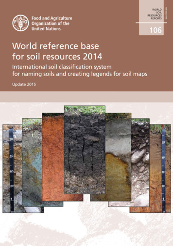
Cover photographs (left to right):Ekranic Technosol – Austria ( Erika Michéli)Reductaquic Cryosol – Russia ( Maria Gerasimova)Ferralic Nitisol – Australia ( Ben Harms)Pellic Vertisol – Bulgaria ( Erika Michéli)Albic Podzol – Czech Republic ( Erika Michéli)Hypercalcic Kastanozem – Mexico ( Carlos Cruz Gaistardo)Stagnic Luvisol – South Africa ( Márta Fuchs)Copies of FAO publications can be requested from:SALES AND MARKETING GROUPInformation DivisionFood and Agriculture Organization of the United NationsViale delle Terme di Caracalla00100 Rome, ItalyE-mail: publications-sales@fao.orgFax: ( 39) 06 57053360Web site: http://www.fao.org
World reference basefor soil resources 2014International soil classification systemfor naming soils and creating legends for soil mapsUpdate 2015FOOD AND AGRICULTURE ORGANIZATION OF THE UNITED NATIONSRome, 2015WORLDSOILRESOURCESREPORTS106
The designations employed and the presentation of material in this informationproduct do not imply the expression of any opinion whatsoever on the part of theFood and Agriculture Organization of the United Nations (FAO) concerning the legalor development status of any country, territory, city or area or of its authorities, orconcerning the delimitation of its frontiers or boundaries. The mention of specificcompanies or products of manufacturers, whether or not these have been patented,does not imply that these have been endorsed or recommended by FAO in preferenceto others of a similar nature that are not mentioned.The views expressed in this information product are those of the author(s) and do notnecessarily reflect the views or policies of FAO.ISBN 978-92-5-108369-7 (print)E-ISBN 978-92-5-108370-3 (PDF) FAO, 2014Recommended citation:IUSS Working Group WRB. 2015. World Reference Base for Soil Resources 2014, update 2015International soil classification system for naming soils and creating legends for soil maps.World Soil Resources Reports No. 106. FAO, Rome.FAO encourages the use, reproduction and dissemination of material in this informationproduct. Except where otherwise indicated, material may be copied, downloaded andprinted for private study, research and teaching purposes, or for use in non-commercialproducts or services, provided that appropriate acknowledgement of FAO as the sourceand copyright holder is given and that FAO’s endorsement of users’ views, products orservices is not implied in any way.All requests for translation and adaptation rights, and for resale and other commercialuse rights should be made via www.fao.org/contact-us/licence-request or addressed tocopyright@fao.org.FAO information products are available on the FAO website (www.fao.org/publications)and can be purchased through publications-sales@fao.org.
iiiContentsForewordvAcknowledgementsviList of acronymsviiChapter 1. Background and basics11.1 History11.2 Major changes in WRB 201421.3 The object classified in the WRB31.4 Basic principles41.5 Architecture91.6 Topsoils111.7 Translation into other languages11Chapter 2. The rules for classifying soils and creating map legends122.1 General rules122.2 Rules for classifying soils132.3 Rules for creating map legends142.4 Subqualifiers162.5 Buried soils21Chapter 3. Diagnostic horizons, properties and materials22Diagnostic horizons22Diagnostic properties61Diagnostic materials76Chapter 4. Key to the Reference Soil Groupswith lists of principal and supplementary qualifiers85Chapter 5. Definitions of Qualifiers117References140Annex 1. Description, distribution, use andmanagement of Reference Soil Groups144
ivAnnex 2. Summary of analytical procedures for soil characterization182Annex 3. Recommended codes for the Reference Soil Groups,qualifiers and specifiers187Annex 4. Soil particle-size and texture classes192
vForewordThe first edition of the World Reference Base for Soil Resources (WRB) was releasedat the 16th World Congress of Soil Science at Montpellier in 1998. At the same event,it was also endorsed and adopted as the system for soil correlation and internationalcommunication of the International Union of Soil Sciences (IUSS). The second editionof the WRB was released at the 18th World Congress at Philadelphia in 2006.After an additional eight years of intensive worldwide testing and data collection,the third edition of the WRB is presented. This publication builds on and reflects thevaluable work of the authors of the earlier drafts and editions of the WRB, as well asthe experiences and contributions of many soil scientists who participated in the workof the IUSS Working Group on the WRB.The WRB is a soil classification system for naming soils and creating soil map legends.It is hoped that this publication will contribute to the understanding of soil science inthe general public and in the scientific community.The publication has been made possible by the sustained efforts of a large group ofexpert authors, as well as the cooperation and logistic support of the IUSS and theFood and Agriculture Organization of the United Nations (FAO).Peter Schad (Chair)Cornie van Huyssteen (Vice-Chair)Erika Michéli (Secretary)IUSS Working Group WRBRonald VargasLand and Water Development DivisionFood and Agriculture Organization of the United Nations (FAO)
viAcknowledgementsThis edition has been compiled under the leadership of Peter Schad (TechnischeUniversität München, Freising, Germany), Cornie van Huyssteen (University of theFree State, Bloemfontein, South Africa) and Erika Michéli (Szent István University,Gödöllő, Hungary).The fundamental decisions have been made by the members of the WRB Board: LúciaAnjos (Brazil), Carlos Cruz Gaistardo (Mexico), Seppe Deckers (Belgium), StefaanDondeyne (Belgium), Einar Eberhardt (Germany), Maria Gerasimova (Russia), BenHarms (Australia), Arwyn Jones (European Commission), Pavel Krasilnikov (Russia),Thomas Reinsch (United States of America), Ronald Vargas (FAO), and Ganlin Zhang(China). Language editing was performed by Ben Harms (Australia).The current third edition received contributions from many scientists, among themare: David Badia Villas (Spain), Frank Berding (The Netherlands), Hans-PeterBlume (Germany), Vanda Buivydaite (Lithuania), Wolfgang Burghardt (Germany),Przemysław Charzynski (Poland), Joe Chiaretti (United States of America), JuanComerma (Venezuela), Carmelo Dazzi (Italy), Mahmut Dingil (Turkey), ArnulfoEncina Rojas (Paraguay), Márta Fuchs (Hungary), Luise Giani (Germany), SergeyGoryachkin (Russia), Alfred Hartemink (United States of America), Juan José IbañezMartí (Spain), Plamen Ivanov (Bulgaria), Reinhold Jahn (Germany), Jerôme Juilleret(Luxembourg), Cezary Kabała (Poland), Andrzej Kacprzak (Poland), Arno Kanal(Estonia), Nikolay Khitrov (Russia), Roger Langohr (Belgium), Xavier Legrain(Belgium), Andreas Lehmann (Germany), Peter Lüscher (Switzerland), GerhardMilbert (Germany), Brian Murphy (Australia), Freddy Nachtergaele (FAO), OtmarNestroy (Austria), Åge Nyborg (Norway), Tatiana Prokofieva (Russia), DavidRossiter (The Netherlands), Daniela Sauer (Germany), Jaroslava Sobocká (Slovakia),Karl Stahr (Germany), Leigh Sullivan (Australia), Wenceslau Teixeira (Brazil), ŁukaszUzarowicz (Poland).The Working Group is greatly indebted to two brilliant soil scientists who madetremendous contributions to the development of the WRB and have sadly passed away:Rudi Dudal (Belgium, 1926–2014) was the lead author of the Soil Map of the World,and Otto Spaargaren (The Netherlands, 1944–2015) was for a long time the leadingscientist of the WRB Working Group.Finally, the Working Group wishes to express its gratitude to the FAO for its supportand for making possible the printing and distribution of this publication.
viiList of acronymsAldithAluminium extracted by a dithionite-citrate-bicarbonate solutionAloxAluminium extracted by an acid ammonium oxalate solutionAlpyAluminium extracted by a pyrophosphate solutionCaCO3Calcium carbonateCECCation exchange capacityCOLECoefficient of linear extensibilityECElectrical conductivityECeElectrical conductivity of saturation extractESPExchangeable sodium percentageFAOFood and Agriculture Organization of the United NationsFedithIron extracted by a dithionite-citrate-bicarbonate solutionFeoxIron extracted by an acid ammonium oxalate solutionFepyIron extracted by a pyrophosphate solutionHClHydrochloric acidISRICInternational Soil Reference and Information CentreISSSInternational Society of Soil ScienceIUSSInternational Union of Soil SciencesKOHPotassium hydroxideKClPotassium chlorideMndithManganese extracted by a dithionite-citrate-bicarbonate solutionNaOHSodium hydroxideNH4OAcAmmonium acetateODOEOptical density of the oxalate extractRSGReference Soil Group
viiiSARSodium adsorption ratioSioxSilicon extracted by an acid ammonium oxalate solutionSiO2SilicaSUITMASoils in Urban, Industrial, Traffic, Mining and Military Areas (IUSSworking group)TRBTotal reserve of basesUNESCO United Nations Educational, Scientific, and Cultural OrganizationUSDAUnited States Department of AgricultureWRBWorld Reference Base for Soil Resources
Chapter 1 - Background and basicsChapter 1Background and basics1.1 HistoryFrom its beginnings to the second edition 2006The World Reference Base (WRB) is based on the Legend (FAO-Unesco, 1974) and theRevised Legend (FAO, 1988) of the Soil Map of the World (FAO-Unesco, 1971-1981).In 1980, the International Society of Soil Science (ISSS, since 2002 the InternationalUnion of Soil Sciences, IUSS) formed a Working Group ‘International Reference Basefor Soil Classification’ for further elaboration of a science based international soilclassification system. This Working Group was renamed ‘World Reference Base forSoil Resources’ in 1992. The Working Group presented the first edition of the WRBin 1998 (FAO, 1998) and the second edition in 2006 (IUSS Working Group WRB,2006). In 1998, the ISSS Council endorsed the WRB as its officially recommendedterminology to name and classify soils.A detailed description of the WRB history before 2006 is given in the second editionof the WRB (IUSS Working Group WRB, 2006).From the second edition 2006 to the third edition 2014The second edition of the WRB was presented at the 18th World Congress ofSoil Science 2006 in Philadelphia, USA (book: IUSS Working Group WRB, 2006;file: ftp://ftp.fao.org/agl/agll/docs/wsrr103e.pdf. After publication, some errors andneeds for improvement were identified, and an electronic update was published in2007 esources/pdf documents/wrb2007 red.pdf.The second edition was translated into several languages. The Russian translation isof the 2006 printed version; whereas all other translations are of the 2007 electronicupdate: Arabic, German, Polish, Slovak, Spanish, and Turkish.Since 2006, several WRB field correlation tours were organized to test the secondedition:2007: Germany (special topic: Technosols and Stagnosols)2009: Mexico2010: Norway2011: Poland2012: Australia (Victoria and Tasmania)2013: Russia (ultra-continental permafrost soils in Sakha)1
World reference base for soil resources 20142The field tours associated with the meetings of the IUSS Commission on SoilClassification in Chile (2008) and the United States (Nebraska and Iowa, 2012) wereadditional tests of the second edition and also the tours offered with the 19th WorldCongress of Soil Science 2010 in Australia.The second edition of the WRB is a system to classify soils. Soon after its publication,there was an identified demand to create map legends using the WRB. For thispurpose, the ‘Guidelines for constructing small-scale map legends using the WRB’were published in 2010 s/en/.They were recommended for map scales of 1 : 250 000 or smaller. The version forclassifying soils (2006/07) and the version for creating map legends (2010) are based onthe same definitions, but use different qualifier sequences and different rules for usingthe qualifiers (see below).Now, after 8 years, a third edition has been prepared.1.2 Major changes in WRB 2014The major changes are: The qualifier sequences and the rules for qualifier usage are now suitable forboth classifying soils and creating map legends. They are now subdivided intoprincipal qualifiers (ranked for every Reference Soil Group, RSG, in order ofrelevance) and supplementary qualifiers (not ranked). The only change at the Reference Soil Group (RSG) level is to replaceAlbeluvisols by Retisols. Retisols have a broader definition and include theformer Albeluvisols. Fluvisols have moved down in the key to be the second last RSG. The Umbrisolsare now placed directly after Phaeozems. The following RSGs switched theirpositions: Solonetz and Vertisols, Durisols and Gypsisols, Cambisols andArenosols. The soils characterized by an argic horizon now have the followingorder: Acrisols – Lixisols – Alisols – Luvisols. The definition of Gleysols has been broadened. The definition of Acrisols, Alisols, Luvisols and Lixisols has been narrowed bysetting the lower depth limit for the occurrence of the argic horizon uniformlyto 100 cm. This implicitly widens the definition of Arenosols. There are now two different types of base saturation in use. First, the effectivebase saturation is used to separate Acrisols from Lixisols, Alisols from Luvisolsand the Dystric qualifier from the Eutric qualifier. It is defined in WRB asexchangeable(Ca Mg K Na) / exchangeable(Ca Mg K Na Al);exchangeable bases by 1 M NH4OAc (pH 7), exchangeable Al by 1 M KCl(unbuffered). Second, the base saturation (pH 7) is used for all other purposes.It is defined in WRB as exchangeable(Ca Mg K Na) / CEC (pH 7); CECand exchangeable bases by 1 M NH4OAc (pH 7). Three new diagnostic horizons have been defined. The chernic horizon replacesthe voronic horizon and is required for Chernozems. The pretic horizon allows
Chapter 1 - Background and basicsa better accommodation of ‘Terra preta de Indio’ within the Anthrosols. Theprotovertic horizon (the former vertic properties) describes layers with weaklyexpressed shrink-swell features. The anthric, takyric and yermic horizons have been changed to diagnosticproperties. ’Retic properties’ are a newly introduced diagnostic property in order tocharacterize Retisols. ‘Albeluvic glossae’ replaces ‘albeluvic tonguing’. ‘Shrinkswell cracks’ are a new diagnostic property that is useful for the definition ofVertisols and related soils. Some new names have been created: ‘protocalcic properties’ (instead of‘secondary carbonates’), ‘sideralic properties’ (instead of ‘ferralic properties’).The ‘gleyic colour pattern’ and the ‘stagnic colour pattern’ are now ‘gleyicproperties’ and ‘stagnic properties’ repectively. The ‘abrupt textural change’ hasbeen renamed ‘abrupt textural difference’; and ‘lithological discontinuity’ is now‘lithic discontinuity’. The albic horizon has been redefined as ‘albic material’. ‘Soil organic carbon’ has been introduced to separate pedogenetic organic carbonfrom organic carbon that satisfies the diagnostic criteria of artefacts. ‘Dolomiticmaterial’ is a new diagnostic material. ‘Hypersulfidic material’ and ‘hyposulfidicmaterial’ are introduced as specific varieties of sulfidic material. ‘Technic hard rock’ has been renamed ‘technic hard material’. Major improvements have been made in the definitions of the argic and natrichorizons, in the depth criteria of the mollic and umbric horizons and in theseparation between organic and mineral materials. Several new qualifiers have been added to give more information about someimportant soil properties. Precise rules have been introduced for the use ofspecifiers to define subqualifiers. The WRB should be able to express characteristics regarded as important innational systems. Some amendments have been made to allow for the betterrepresentation of soil units in the WRB, for example from the Australian andthe Brazilian systems. Some parts of the world had not previously been well represented in the WRBsystem before, e.g. ultra-continental permafrost soils. The system has beenenlarged to allow a better classification of these soils. Efforts have been made to improve the clarity of definitions and terminology.1.3 The object classified in the WRBLike many common words, ‘soil’ has several meanings. In its traditional meaning, soilis the natural medium for the growth of plants, whether or not it has discernible soilhorizons (Soil Survey Staff, 1999).3
World reference base for soil resources 20144In the 1998 WRB, soil was defined as:“ a continuous natural body which has three spatial and one temporal dimension. Thethree main features governing soil are: It is formed by mineral and organic constituents and includes solid, liquid andgaseous phases. The constituents are organized in structures, specific for the pedological medium.These structures form the morphological aspect of the soil cover, equivalent tothe anatomy of a living being. They result from the history of the soil cover andfrom its actual dynamics and properties. Study of the structures of the soil coverfacilitates perception of the physical, chemical and biological properties; it permitsunderstanding the past and present of the soil, and predicting its future. The soil is in constant evolution, thus giving the soil its fourth dimension, time.”Although there are good arguments to limit soil survey and mapping to identifiablestable soil areas with a certain thickness, the WRB has taken the more comprehensiveapproach to name any object forming part of the epiderm of the earth (Sokolov, 1997;Nachtergaele, 2005). This approach has a number of advantages; notably that it allowsfor the tackling environmental problems in a systematic and holistic way, and avoidssterile discussion on a universally agreed definition of soil and its required thicknessand stability. Therefore, the object classified in the WRB is: any material within 2 m ofthe Earth’s surface that is in contact with the atmosphere, excluding living organisms,areas with continuous ice not covered by other material, and water bodies deeper than2 m1. If explicitly stated, the object classified in the WRB includes layers deeper than2 m.The definition includes continuous rock, paved urban soils, soils of industrial areas,cave soils as well as subaqueous soils. Soils under continuous rock, except those thatoccur in caves, are generally not considered for classification. In special cases, theWRB may be used to classify soils under rock, for example for palaeopedologicalreconstruction of the environment.1.4 Basic principlesGeneral principles The classification of soils is based on soil properties defined in terms ofdiagnostic horizons, diagnostic properties and diagnostic materials, which to thegreatest extent possible should be measurable and observable in the field. Table1 provides an overview of the diagnostics uned in the WRB. The selection of diagnostic characteristics takes into account their relationshipwith soil forming processes. An understanding of soil-forming processescontributes to a better characterization of soils but these processes should not,as such, be used as differentiating criteria. To the extent possible at a high level of generalization, diagnostic features thatare of significance for soil management are selected.1In tidal areas, the depth of 2 m is to be applied at mean low water springs.
Chapter 1 - Background and basics Climate parameters are not applied in the classification of soils. It is understoodthat they should be used for interpretation purposes, in combination with soilproperties, but they should not form part of soil definitions. The classification ofsoils is therefore not subordinated to the availability of climate data. The nameof a certain soil will not become obsolete due to global or local climate change. The WRB is a comprehensive classification system that enables accommodationof national soil classification systems. The WRB is not intended to be a substitute for national soil classificationsystems, but rather to serve as a common denominator for communication atthe international level. The WRB comprises two levels of categorical detail:- the First Level having 32 Reference Soil Groups (RSGs);- the Second Level, consisting of the name of the RSG combined with a set ofprincipal and supplementary qualifiers. Many RSGs in the WRB are representative of major soil regions so as to providea comprehensive overview of the world’s soil cover. Definitions and descriptions reflect variations in soil characteristics that occurboth vertically and laterally in the landscape. The term Reference Base is connotative of the common denominator function ofthe WRB: its units (RSGs) have sufficient width to facilitate harmonization andcorrelation with existing national systems. In addition to serving as a correlation between existing classification systems,the WRB also serves as a communication tool for compiling global soil databasesand for the inventory and monitoring of the world’s soil resources. The nomenclature used to distinguish soil groups retains terms that have beenused traditionally or that can be introduced easily into current language. Theyare defined precisely, in order to avoid the confusion that occurs where namesare used with different connotations.Table 1The diagnostic horizons, properties and materials of the WRBNote -– this table does not provide definitions. For diagnostic criteria, please refer to Chapter 3.NameSimplified Description1. Anthropogenic diagnostic horizons (all are mineral)anthraquic horizonin paddy soils: the layer comprising the puddled layer and the plough pan,both showing a reduced matrix and oxidized root channelshortic horizondark, high content of organic matter and P, high animal activity, highbase saturation; resulting from long-term cultivation, fertilization andapplication of organic residueshydragric horizonin paddy soils: the layer below the anthraquic horizon showingredoximorphic features and/or an accumulation of Fe and/or Mn5
World reference base for soil resources 20146irragric horizonuniformly structured, at least moderate content of organic matter, highanimal activity; gradually built up by sediment-rich irrigation waterplaggic horizondark, at least moderate content of organic matter, sandy or loamy; resultingfrom application of sods and excrementspretic horizondark, high content of organic matter and P, low animal activity, highcontents of exchangeable Ca and Mg, with remnants of charcoal and/orartefacts; including Amazonian Dark Earthsterric horizonshowing a colour related the source material, high base saturation;resulting from adding mineral material (with or without organic residues)and deep cultivation2. Diagnostic horizons that may be organic or mineralcryic horizonperennially frozen (visible ice or, if not enough water, 0 C)calcic horizonaccumulation of secondary carbonates, non-cementedfulvic horizonandic properties, highly humified organic matter, higher ratio of fulvic acidsto humic acidsmelanic horizonandic properties, highly humified organic matter, lower ratio of fulvic acidsto humic acids, blackishsalic horizonhigh amounts of readily soluble saltsthionic horizonwith sulfuric acid and a very low pH3. Organic diagnostic horizonsfolic horizonorganic layer, not water-saturated and not drainedhistic horizonorganic layer, water-saturated or drained4. Surface mineral diagnostic horizonschernic horizonthick, very dark-coloured, high base saturation, moderate to high contentof organic matter, well-structured, high biological activity (special case ofthe mollic horizon)mollic horizonthick, dark-coloured, high base saturation, moderate to high content oforganic matter, not massive and hard when dryumbric horizonthick, dark-coloured, low base saturation, moderate to high content oforganic matter, not massive and hard when dry5. Other mineral diagnostic horizons related to the accumulation of substances due to(vertical or lateral) migration processesargic horizonsubsurface layer with distinctly higher clay content than the overlying layerand/or presence of illuvial clayduric horizonconcretions or nodules, cemented or indurated by silicaferric horizon 5% reddish to blackish concretions and/or nodules or 15% reddish toblackish coarse mottles, with accumulation of Fe (and Mn) oxidesgypsic horizonaccumulation of secondary gypsum, non-cementednatric horizonsubsurface layer with distinctly higher clay content than the overlying layerand/or presence of illuvial clay; high content of exchangeable Napetrocalcic horizonaccumulation of secondary carbonates, relatively continuously cemented orinduratedpetroduric horizonaccumulation of secondary silica, relatively continuously cemented orinduratedpetrogypsic horizonaccumulation of secondary gypsum, relatively continuously cemented orinduratedpetroplinthichorizonsheet of connected yellowish, reddish and/or blackish concretions and/ornodules or of concentrations in platy, polygonal or reticulate patterns; highcontents of Fe oxides at least in the concretions, nodules or concentrations;relatively continuously cemented or induratedpisoplinthic horizon 40% strongly cemented to indurated, yellowish, reddish, and/or blackishconcretions and/or nodules, with accumulation of Fe oxides
Chapter 1 - Background and basicsplinthic horizon 15% (single or in combination) of reddish concretions and/or nodules orof concentrations in platy, polygonal or reticulate patterns; high contents ofFe oxides, at least in the concretions, nodules or concentrationssombric horizonsubsurface accumulation of organic matter other than in spodic or natrichorizonsspodic horizonsubsurface accumulation of organic matter and/or Fe and Al6. Other mineral diagnostic horizonscambic horizonevidence of pedogenic alteration; not meeting the criteria of diagnostichorizons that indicate stronger alteration or accumulation processesferralic horizonstrongly weathered; dominated by kaolinites and oxidesfragic horizonstructure compact to the extent that roots and percolating water penetrateonly along interped faces; non-cementednitic horizonrich in clay and Fe oxides, moderate to strong structure, shiny aggregatefacesprotovertic horizoninfluenced by swelling and shrinking claysvertic horizondominated by swelling and shrinking clays7. Diagnostic properties related to surface characteristicsaridic propertiessurface layer characteristics of soils under arid conditionstakyric propertiesheavy-textured surface layers under arid conditions in periodically floodedsoils (special case of aridic properties)yermic propertiespavement and/or vesicular layer in soils under arid conditions (special caseof aridic properties)8. Diagnostic properties defining the relationship between two layersabrupt texturaldifferencevery sharp increase in clay content within a limited depth rangealbeluvic glossaeinterfingering of coarser-textured and lighter coloured material into anargic horizon forming vertically continuous tongues (special case of reticproperties)lithic discontinuitydifferences in parent materialretic propertiesinterfingering of coarser-textured and lighter coloured material into anargic or natric horizon9. Other diagnostic propertiesandic propertiesshort-range-order minerals and/or organo-metallic complexesanthric propertiesapplying to soils with mollic or umbric horizons, if the mollic or umbrichorizon is created or substantially transformed by humanscontinuous rockconsolidated material (excluding cemented or indurated pedogenetichorizons)geric propertiesvery low effective CEC and/or acting as anion exchangergleyic propertiessaturated with groundwater (or upwards moving gases) long enough thatreducing conditions occurprotocalcicpropertiescarbonates derived from the soil solution and precipitated in the soil(secondary carbonates), less pronounced than in calcic or petrocalcichorizonsreducing conditionslow rH value and/or presence of sulfide, methane or reduced Feshrink-swell cracksopen and close due to swelling and shrinking of clay mineralssideralic propertiesrelatively low CECstagnic propertiessaturated with surface water (or intruding liquids), at least temporarily,long enough that reducing conditions occur7
World reference base for soil resources 20148vitric properties 5% (by grain count) of volcanic glass and related materials and containinga limited amount of short-range-order minerals and/or organo-metalliccomplexes10. Diagnostic materials related to the concentration of organic carbonmineral material 20% soil organic carbonorganic material 20% soil organic carbonsoil organic carbonorganic carbon that does not meet the diagnostic criteria of artefacts11. Diagnostic material related to colouralbic materiallight-coloured fine earth, expressed by high Munsell value and low chroma12. Technogenic diagnostic materials (predominantly understood as parent materials)artefactscreated, substantially modified or brought to the surface by humans; nosubsequent substantial change of chemical or mineralogical propertiestechnic hardmaterialconsolidated and relatively continuous material resulting from an industrialprocess13. Other diagnostic materials (predominantly understood as parent materials)calcaric material 2% calcium carbonate equivalent, inherited from the parent materialcolluvic materialheterogeneous mixture that has moved down a slopedolomitic material 2% of a mineral that has a ratio CaCO3/MgCO3 1.5fluvic materialfluviatile, marine or lacustrine deposits with evident stratificationgypsiric material 5% gypsum, at least partially inherited from the parent materialhypersulfidicmaterialsulfidic material capable of severe acidificationhyposulfidicmaterialsulfidic material not capab
IUSS Working Group WRB. 2015. World Reference Base for Soil Resources 2014, update 2015 International soil classification system for naming soils and creating legends for soil maps. World Soil Resources Reports No. 106. FAO, Rome. product. Except where otherwise indicated, material may be copied, downloaded and