Transcription
Engineering, Technology & Applied Science ResearchVol. 9, No. 2, 2019, 3959-39643959Real-Time Water Quality Monitoring For SmallAquatic Area Using Unmanned Surface VehicleAlexander T. DemetilloEvelyn B. TaboadaCollege of Engineering and Information TechnologyCaraga State UniversityButuan City, Philippinesatdemetillo@carsu.edu.phSchool of EngineeringUniversity of San CarlosCebu City, Philippinesevelynbtaboada@gmail.comAbstract—Most developing countries depend on conventionalwater quality monitoring methods which are usually expensive,complicated, and time-consuming. In recent years, stationary andportable water quality monitoring and a mobile surface vehiclehave increased the utilization of on-site water measurements andmonitoring. The first has the disadvantage of small coverage areawhile the second has its cost and operational complexity. Thispaper addresses these issues by placing materials and equipmentused in fixed online water quality monitoring and using acustomized and low-cost unmanned surface vehicle. Themeasurements are taken automatically on the equipmentonboard the unmanned surface vehicle (USV), transmittedwirelessly to a PC-based remote station or nearby stations andsaved there in a dedicated database. The overall systemcomprises a commercial water quality sensor, a GSM and Zigbeemodule for a wireless communication system, a low-cost mobilityplatform, and the location/positioning system. During testing, allcaptured data like water quality parameters, location, and otheressential parameters were collated, processed and stored in adatabase system. Relevant information from the USV can beviewed on a smartphone or a computer. The USV was also testedto conduct unmanned water quality measurements using the preinputted navigation route which shows a good result innavigation and data transmission. Water bodies with calm watersuch as lakes and rivers can use the USV, in a stand-alone modeor as a part of a networked sensor system.Keywords-unmanned surface vehicle; water quality monitoring;wireless transmissionI.INTRODUCTIONBecause of population increase, industrialization andclimate change, water demand is increasing at an alarming rate[1-3]. The sources of potable water are limited and vulnerable,thus the need for water quality monitoring in rivers, lakes, andother freshwater bodies is becoming a more pressing issue [4].There is a growing demand to implement a mechanism toenhance the effectiveness of existing water quality monitoringmethods. Mostly, water quality information gathering usestraditional or manual methods for various reasons ranging fromlack of technology capacity, human resources and financialconstraints [5-7]. These techniques or methodologies areusually accurate and inexpensive, but suffer from variousdisadvantages like the loss of vital information duringtransport, limited samples, and cost-effectiveness. They cannotperform real-time monitoring which could mitigate or preventuncertain happenings in a particular area [8].Nowadays, some advanced countries perform water qualitymonitoring using innovative technologies like utilizing anelectrochemical sensor which can give water qualityinformation in real-time [10-11], maximizing the advantages ofrecent technology by combining electrochemical sensors withwireless communication technology [11]. The systemautomatically senses data, transmits it to the notification nodeand will alarm if the parameters exceed their limits. Authors in[12] successfully demonstrated a method of deployment of awireless sensor network with a mechanism to reduce trafficbetween base and remote stations for water quality monitoringwherein stationary stations could detect essential waterparameters in real time. Gathered data were transmitted everyfive minutes to the base station through multi-hoop routingusing a flooding routing protocol. However, the stationaryplatform also has the disadvantages of high cost of covering thewhole study area [13], of provision of sensors in everysampling point and lack of mobility [14]. With these, thedevelopment of a mobile technology which will take advantageof the water quality monitoring capability of the stationarysensors and add mobility to enhance coverage, effectiveness,and efficiency of water monitoring is necessary [15]. USVtechnology with sensors on board could cater and house moreresearch tools, thus improving the methods of water qualitymonitoring. Mobile vehicles in a marine or aquatic area couldfurther increase the coverage of an automated water qualitymonitoring system with its ability to transfer from one locationto another thus increasing the spatial and temporalmeasurement capability of the whole system. They can provideprotection (housing and floatation) to the electronic equipmentneeded for monitoring and getting samples of the research area.With the advancement of computational ability, options formore monitoring equipment on board the USV increasedthrough the utilization of new and innovative samplingmethods [17, 18]. This led to the increasing trend of usingdifferent approaches, design, and implementation in a mobilevehicle for WQMS endeavor.Among many types of water surface vehicles for water andenvironmental monitoring, autonomous underwater vehicleCorresponding author: Alexander T. Demetillowww.etasr.comDemetillo & Taboada: Real-Time Water Quality Monitoring For Small Aquatic Area Using Unmanned
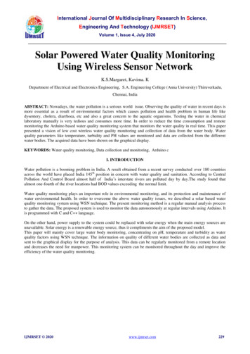
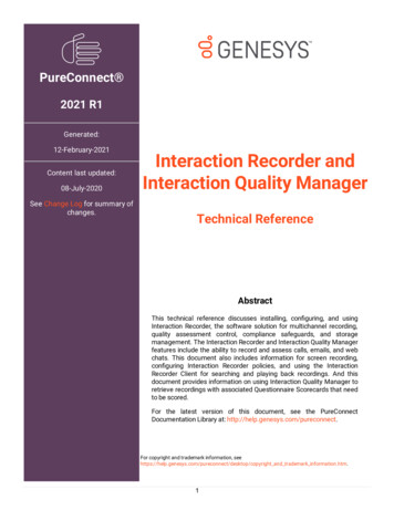
Engineering, Technology & Applied Science ResearchVol. 9, No. 2, 2019, 3959-39643960(AUV), unmanned surface vehicle (USV), and autonomoussurface vehicle (ASV) are the most widely used [18]. ASV hasthe capabilities of large-area monitoring and worry-freeunmanned navigation which is the ideal scenario for waterquality monitoring, but comes with a high cost [19], whileAUV also can be a handy tool, especially in dangerous areas,but has also a high price along with its complex operation andsetup [20]. USVs offer the advantages of being less expensiveand having simpler supervision compared to UAV, while theyare easy to customize for a hybrid operation depending on theactual situation of the study area like an obstacle or floatingobjects which can be hardly detected using automation.make up continuous monitoring systems essential in theinvestigation and characterization of some water qualityparameters like pH and temperature which have veryinconsistent characteristics. Received data can be furtheranalyzed and may serve as input to decision making.Several aquatic mobile vehicles have been developed forwater quality monitoring with some enhancements likecustomized platforms to fit the actual conditions of the area[21], communication systems [22], and energy systems andmechanisms to cater the much-needed power of the vehicle[24, 25]. Some known USV projects for water qualitymonitoring include bathymetric survey [25], data acquisitionsystem on large fish and marine mammal movements [26],research on marine inhabitant activities [28-30], coastalenvironmental monitoring and pollutant tracking [13],emergency response and survey of damages [30], dataacquisition and sampling for sea water and air [31]. Authors in[33] focused on the improvement of surface vehicle platforms,communications and coordination, propulsion, control andother crucial improvements. They covered basic importantWQM parameters ranging from temperature to sodium withdata being wirelessly transmitted to a nearby computer systemfor storage. Authors in [34] proposed another low-cost USVwater quality monitoring, but with emphasis on inland waterresources, while authors in [35] studied a multi-robot systemapproach to monitoring coastal waters, rivers, and lagoons inreal-time with added features for the monitoring of heavy metalconcentrations. Measurement of marine important parameterslike partial pressure and sea-air fluxes of CO2 were conductedin [36]. The USV in [37] collects water samples in differentwater depths, places them in different water containers, andbrings the samples for laboratory analysis. A remote-controlledwatercraft with an automatic calibrator for sensors that needfrequent calibration like pH was studied in [38] and low-costbathymetry and depth monitoring in real time were performedin [25].The primary goal of the USV is to give an alternativemethod in water quality monitoring in dangerous areas andhigh-risk jobs. To collect data in hard to reach areas [19], toimprove the data collection frequency, which if done manuallycould lead to expensive and laborious endeavor. Figure 1shows the diagram of the proposed system in which datacollection is automated. Figure 2 shows the USV prototypeduring its first testing. Boat materials available in the area wereused for creating its body and motor and its controllers arecommercially available WQ sensors from Atlas Scientific (pHand temperature) making this design ready for replication.Also, to make it affordable, open source software was utilized.This software is used to receive and accumulate data acquiredfrom the onboard sensors of the USV as an input interface fornavigational operation setup, and to download the predefinedUSV direction. The system is divided in four subsystems,namely USV platform, automated sensor system, applicationsoftware, and a base station.Small water bodies like lakes and rivers usually haveshallow waters which are difficult and too expensive for anenvironmental ship to monitor. Operations in shallow watersrequire having a low draft and protection mechanism for thepropellers. USV is able to operate in shallow waters withpossible floating materials and plants such as water lilies, fishpens, and other barriers. With constraints for its total weight, itonly allows a very minimalistic payload to be onboard the USVlike a sensor, communication and navigational equipment withtheir electronics parts. The USV aims to provide a low-costmethod capable of bringing information about waterphysicochemical parameters in real-time. This real-timemonitoring can be an aid to the traditional or conventionalmethods of water quality monitoring which have highsensitivity, but seldom perform satisfyingly for budgetaryconstraints and other reasons. Instead, USV utilization wouldwww.etasr.comThis study focuses on the design of an unmanned mobilevehicle for water quality monitoring with consideration of theactual requirements and scenarios of the target area which isLake Mainit, Philippines. Its main features are its affordabilityand adaptability to the field of study.II.Fig. 1.MATERIALS AND METHODSDiagram of mobile water quality monitoringFig. 2.USV prototypeDemetillo & Taboada: Real-Time Water Quality Monitoring For Small Aquatic Area Using Unmanned
Engineering, Technology & Applied Science ResearchA. ConstructionMost of the materials used in the catamaran-type USV areavailable online or in the local market. The main goal of thisresearch is to build a floating and mobile platform that canperform water quality monitoring in a sizeable aquatic area thatis too large for the deployment of stationary sensors and toorisky and difficult for manual sampling. USV design considersaffordability, replicability and flexibility to cater to an actualfield situation. The USV was designed and built in the Centerfor Robotics, Automation and Fabrication Technology(CRAFT) of Caraga State University in Butuan City,Philippines. It is an enhancement of the previous project forWQM which uses buoy as floating material, but in a permanentlocation. The area to be covered is set to be 5km2 per day withthe need to sample/measure water in at least 1-meter depth.These requirements are in consideration with the area of theLake Mainit of Caraga region in the Philippines where miningactivities are rampant. These facts led to a consideration of aminimum speed of 1 nautical mile (0.5m/s), and a maximumweight of 40kg. A catamaran-type of construction was chosenfor its proven stability on water, which allows easy control. TheUSV can be operated using remote control or can be automateddepending on the location of the area and the distance it willcover. The operator might opt for remote-controlled operationif the area is small and there is a presence of an obstacle orfloating materials or species that might destroy or damage theUSV propeller, the casing or onboard sensors. The automaticoperation fits with considerable area coverage with noobstruction or floating objects. The operator can design amission plan and define its coordinates for the samplinglocation. With these, deployment makes data gatheringunmanned and automated in dangerous and difficult to reachareas.B. Electronic ModuleIn terms of electronic components, the USV systemcomprises of two subsystems: USV unit and ground controlstation with corresponding electronic equipment. The groundcontrol station comprises of a computer system (laptop/PC) andwireless transceivers linking with the USV. The ground controlhas also the path/direction application program used inupdating the USV path and pointing of sampling if needed.Communication module comprises of telemetry, Xbee, and RCmodules. The data related to the mobility of the USV arecatered by the Ardupilot using telemetry. XBee module is usedto transmit the gathered data to the nearest station while theremote controller (RC) module is used for the manualnavigation control of the USV. It used a customized missionplanner using an open source program powered by ArduinoIDE to control the navigational operation of the USV. For acontinuous operation, a mission plan must be downloaded tothe microcontroller before the start of the mission. Theautomated operation used a compass board and GPS module asa means to follow the predefined navigational route. Sensing ofdata is the same with the stationary sensor methodology. Thesensor determines the value and after proper conditioning andboosting it will be transferred to the microcontroller forpreprocessing and will be sent to the wireless transceiver fortransmission to the nearest stations or pre-defined cellphonenumbers. Wireless transmission is done through an Xbeewww.etasr.comVol. 9, No. 2, 2019, 3959-39643961technology for short distance and GSM/GPRS transceiver forlong-distance transmission. Arduino IDE is the software usedto configure the microcontroller (Arduino mega 2560), XBeeshort distance communication and GSM/GPS setup for longdistance transmission. XBee module provides wirelessconnectivity to devices using end-point solutions. XBee usesIEEE 802.15.4 networking protocol which is common to lowpower clustering communication setups. For long distancetransmission and reception of data a GSM module is used. Ithas a library which mimics an Arduino board to performoperations same as an ordinary GSM powered cellphone likereceiving and sending messages and connect to the localtelecommunication companies. The GSM/GPRS transceiverhas a built-in modem that facilitates data transfer from a serialport to the GSM network. It will receive data at the controllerby another Xbee. An open source program will process thisdata using Microsoft Visual Studio flat form to facilitate userfriendly display and storage.A triple-axis magnetometer compass board HMC5883L(Honeywell) and a NEO-6M GPS Module (uBlox) control thenavigation system of the USV, designed to cover all functionsfor unmanned operation using a pre-programmed mission plan.The body of the USV platform utilizes marine plyboard withpainting to safeguard the USV onboard electronic components.A wooden material houses the battery and other electroniccomponents and connected to 1.5m (from head to tail) by 1mwide catamaran boat type. The USV can carry a maximumpayload of 40kg. Finally, the wireless transceiver and sensorcalibration were completed before testing the whole system inthe actual application.The water sensor unit is the primary component of themobile water quality monitoring system. In this research, itemployed two sensors from the Atlas Scientific company formeasuring pH and temperature. With the built-in flexibility ofArduino microcontroller, it can add more number of electrodesdepending on the needs. pH and temperature sensors have theirinterface circuits which are also provided by the manufacturer.Only the temperature sensor is connected directly to the analogpin of the microcontroller. It utilized a customized motherboardto connect all electronic components to the microcontroller.Also, the board allows other modules and circuits, while havinga feature to isolate the sensor individually and eliminate issuesof noise. To maintain accuracy, electrodes are calibrated basedon the manufacturer standards and using their own calibrationsolutions. The microcontroller unit is the main part of the USVand makes it unique among other aquatic mobile vehicles. Ithas pins which can expand its utilization. It comprises of ahardware microcontroller and a software program that guidesthe operation of the microcontroller with the rest of the USVparts. This research uses Arduino Mega 256, the mostexpandable Arduino microcontroller to accommodatecapability and future expansion of the system. Same with theearly variant of the Arduino microcontroller, it has an opensource electronics prototyping platform, flexible, easy-to-usehardware, and user friendly programming environment [39].The USV preprocess the data using the preprogrammedcommands downloaded to the microcontroller. The developedsoftware program uploaded into the microcontroller memorysets the sensor node to measure the water quality parameter atDemetillo & Taboada: Real-Time Water Quality Monitoring For Small Aquatic Area Using Unmanned
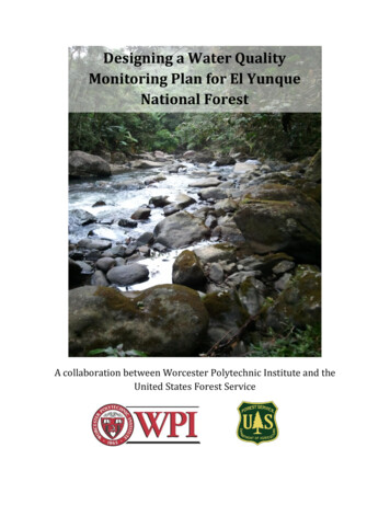
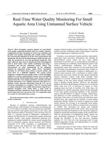
Engineering, Technology & Applied Science Researchpredetermined time intervals. The data are always copied in anSD card before transmission as backup data storage.C. SoftwareThe software for all USV electronic modules controlled bythe microcontroller is written in Arduino IDE while MicrosoftVisual Studio (IDE) was used to develop the Windowsapplication that interfaces the USV output to the computersystems in the base station. Figure 3 shows the flowchart of theUSV software. It uses the Windows application to receive datafrom the serial port that connects the communication link of theUSV. First, the microcontroller initializes all the componentsand waits for the GPS to be ready before it navigates usingeither the preprogrammed path or through remote control.Vol. 9, No. 2, 2019, 3959-3964series of tests were also conducted for its autonomousnavigation. Laboratory tests included measurements of thequality of communication between the control unit and theUSV, and the interruption of the radio link. The results of theconnection measurements conform to the minimum standards.Fig. 4.Fig. 3.USV program flowchartFor RC operation, all programming comes from manualinput of the operator which converts a string of commands andprocesses by the microcontroller for execution like direction,points of sampling, etc. In the autonomous method, themicrocontroller sets the destination points, navigates, gets thecurrent position of the USV from the GPS, reads the sensors,and sends and logs data. With the destination point encoded,the microcontroller navigates until it reaches home location.D. USV DataloggerFor easy data transfer from the USV to base station a datalogger was designed. Figure 4 shows the software applicationinterface for the USV which was developed using VisualStudio. It was designed in such a way that it will display theincoming data in a tabulated form. Also, it provides amechanism of updating the path of the USV using a simpleinputting of values through a graphical interface. The USV’stime to stay and gather data before it will navigate or move toanother location can change through this logger. All necessaryinputs are displayed for the user to review.III.RESULTS AND DISCUSSIONAfter a laboratory bench testing of the different parts of thesystem, the USV was assembled. Navigation trials wereconducted in order to check if specifications were followed. Awww.etasr.com3962USV interface applicationA. Navigation TestingUpon the construction of the vessel prototype, testingfollowed in the creek found inside the University campus.Maneuvering capabilities, vessel stability, and navigation speedwere tested. The results of maneuvering capabilities andstability were outstanding since the catamaran was stable andcould rotate almost around its axis. The average navigationspeed was 1knot, while 180 turn was achieved in less than15s. Also, testing the range of the radio link, stability, andbehavior of the boat at some water disturbances that mimicsmall sea waves was conducted. Tests showed that the radiolink range in the open sea is about 150m.Fig. 5.USV’s pathB. WQM Sensor testingA calibration process was conducted to the electrochemicalsensors in the lab for their accuracy and functionality.Calibration solution interface and isolation circuit from AtlasScientific were utilized to calibrate and test the pH electrodes.For field testing, freshly calibrated electrodes from the lab wereinstalled on the USV side platform. A series of final tests of theelectronic component implemented were conducted before theDemetillo & Taboada: Real-Time Water Quality Monitoring For Small Aquatic Area Using Unmanned
Engineering, Technology & Applied Science Researchactual operation. The configuration of the water quality sensorwas the same with the one used in the laboratory. The USVwas programmed to measure a minute after its arrival at thedesignated testing point or on the points/area where theoperator wanted to make the measurement. Figure 5 shows thedata received from the USV. It shows the effectivity of thesystem by accurately displaying important WQMS parameters,which include pH, temperature, time, date etc. It validates thatthe system performs following the specifications of theelectronic component and the USV delivers its primaryfunction which is to protect components from water intrusion.The test also did not encounter a significant problem except theperiodic GSM signal. The display works well on PCs, laptops,and smart mobile phones. With these, the onboard water sensorand its peripherals can provide the needed resources, thusgiving stakeholders an alternative method on how to conductwater quality monitoring continuously.Vol. 9, No. 2, 2019, Fig. 6.Sample of the output of the system[11]IV. CONCLUSIONSWith changing water environment, the need for a low-costand mobile method of measurement is increasing. In thisresearch, the design and development of a low-cost mobilevehicle as a tool to carry water sensors and transmit theirresults wirelessly was successfully implemented. Utilization ofeasy to find sensors, locally available materials for the USVparts, and development of customized integrated softwareusing open source technology are the main advantages of thesystem when compared with commercial USVs. Laboratoryand on-site results show the USV’s capability to conduct waterquality monitoring in a lake and other small bodies of water.Temperature pH, time and date were transmitted. Inconclusion, this system has the potential to enhance reportingand information dissemination regarding the status of waterquality.ACKNOWLEDGEMENTAuthors wish to thank the scholarship funding given by theDepartment of Science and Technology through itsEngineering Research and Development for Technology(ERDT) Program and the Caraga State University for allowingthe use of its laboratory and ][18]J. Heath, H. P. Binswanger, “Natural Resource Degradation Effects ofPoverty and Population Growth are Largely Policy-induced: The case ofColombia”, Environment and Development Economics, Vol. 1, No. 1,pp. 65-84, 1996W. Mo, H. Wang, J. M. Jacobs, “Understanding the influence of climatechange on the embodied energy of water supply”, Water Research, Vol.95, pp. 220-229, 2016C. Dalin, N. Hanasaki, H. Qiu, D. L. Mauzerall, I. Rodriguez-Iturbe,“Water resources transfers through Chinese interprovincial and foreignfood trade”, Proceedings of the National Academy of Sciences, Vol.111, No. 27, pp. 9774-9779, 2014M. V. Japitana, E. V. Palconit, A. T. Demetillo, M. E. C. Burce, E. B.Taboada, M. L. S. Abundo, “Integrated technologies for low costenvironmental monitoring in the water bodies of the Philippines: Areview”, Nature Environment and Pollution Technology, Vol. 17, No. 4,pp. 1125-1137, 2018K. Kondratjevs, A. Zabasta, N. Kunicina, L. Ribickis, “Development ofpseudo autonomous wireless sensor monitoring system for waterdistribution network”, in: IEEE International Symposium on IndustrialElectronics, pp. 1454–1458, IEEE, 2014N. Nasser, A. Ali, L. Karim, S. Belhaouari, “An efficient WirelessSensor Network-based water quality monitoring system”, ACSInternational Conference on Computer Systems and Applications, Ifrane,Morocco, May 27-30, 2013S. Silva, H. N. Nguyen, V. Tiporlini, K. Alameh, “Web based waterquality monitoring with sensor network: Employing ZigBee and WiMaxtechnologies”, 8th International Conference on High-Capacity OpticalNetworks and Emerging Technologies, Riyadh, Saudi Arabia, December19-21, 2011T. P. Lambrou, C. C. Anastasiou, C. G. Panayiotou, M. M. Polycarpou,“A Low-Cost Sensor Network for Real-Time Monitoring andContamination Detection in Drinking Water Distribution Systems”,IEEE Sensors Journal, Vol. 14, No. 8, pp. 2765-2772, 2014M. Simic, L. Manjakkal, K. Zaraska, G. M. Stojanovic, “TiO2 BasedThick Film pH Sensor”, IEEE Sensor Journals, Vol. 17, No. 2, pp. 248255, 2017E. Hoque, L. H. H. Hsu, A. Aryasomayajula, P. R. Selvaganapathy, P.Kruse, “Pencil-Drawn Chemiresistive Sensor for Free Chlorine inWater”, IEEE Sensors Letters, Vol. 1, No. 4, pp. 1-4, 2017N. A. Cloete, R. Malekian, L. Nair, “Design of Smart Sensors for RealTime Water Quality Monitoring”, IEEE Access, Vol. 4, No. 9, pp. 39753990, 2016W. Y. Chung, J. H. Yoo, “Remote water quality monitoring in widearea”, Sensors Actuators B: Chemical, Vol. 217, pp. 51-57, 2015W. Naeem, T. Xu, R. Sutton, A. Tiano, “The design of a navigation,guidance, and control system for an unmanned surface vehicle forenvironmental monitoring”, Proc. IMeCHE, Vol. 222, No. M, pp. 67-79,2008G. Hitz, F. Pomerleau, M. E. Garneau, C. Pradalier, T. Posch, J.Pernthaler, R. Y. Siegwart, “Autonomous Island Water Monitoring:Design and Application of a Surface Vessel”, IEEE Robotics &.Automation Magazine, Vol. 19, No. 1, pp. 62-72, 2012G. Ferri, A. Manzi, F. Fornai, F. Ciuchi, C. Laschi, “The HydroNetASV, a Small-Sized Autonomous Catamaran for Real-Time Monitoringof Water Quality: From Design to Missions at Sea”, IEEE Journal ofOceanic Engineering, Vol. 40, No. 3, pp. 710-726, 2015G. Ferri, M. Cococcioni, A. Alvarez, “Sampling on-demand with fleetsof underwater gliders”, 2013 MTS/IEEE OCEANS - Bergen, Bergen,Norway, June 10-14, 2013T. Huntsberger, G. Woodward, “Intelligent autonomy for unmannedsurface and underwater vehicles”, OCEANS'11 MTS/IEEE KONA,Waikoloa, USA, September 19-22, 2011J. E. Manley, “Unmanned Maritime Vehicles, 20 years of commercialand technical evolution”, OCEANS 2016 MTS/IEEE Monterey,Monterey, USA, September 19-23, 2016Demetillo & Taboada: Real-Time Water Quality Monitoring For Small Aquatic Area Using Unmanned
Engineering, Technology & Applied Science Research[19] N. Wang, S. Lv, M. J. Er, W. H. Chen, “Fast and Accurate TrajectoryTracking Control of an Autonomous Surface Vehicle With UnmodeledDynamics and Disturbances”, IEEE Transactions on IntelligentVehicles, Vol. 1, No. 3, pp. 230-243, 2016[20] L. Paull, S. Saeedi, M. Seto, H. Li, “AUV navigation and localization: Areview”, IEEE Journal of Oceanic Engineering, Vol. 39, No. 1, pp. 131149, 2014[21] B. Bayat, N. Crasta, A. Crespi, A. M. Pascoal, A. Ijspeert,“Environmental monitoring using autonomous vehicles: a survey ofrecent searching techniques”, Current Opinion in Biotechnology, Vol.45. pp. 76-84, 2017[22] J. Sanchez-Garcia, J. M. Garcia-Campos, M. Arzamendia, D. G. Reina,S. L. Toral, D. Gregor, “A survey on unmanned aerial and aquaticvehicle multi-hop networks: Wireless communications, evaluation toolsand applications”, Computer Communications, Vol. 119, pp. 43-65,2018[23] A. Makhsoos, H. Mousazadeh, S. S. Mohtasebi, M. Abdollahzadeh, H.Jafarbiglu, E. Omrani, Y. Salmani, A. Kiapey, “Design, simulation andexperimental evaluation of energy system for an unmanned surfacevehicle”, Energy, Vol. 148, pp. 362-372, 2018[24] H. Niu, Y. Lu, A. Savvaris, A. Tsourdos, “An energy-efficient pathplanning algorithm for unmanned surface vehicles”, Ocean Engineering,Vol. 161, pp. 308-321, 2018[25] H. Mousazadeh, J. Hamid, O. Elham, M. Farshid, K. Ali, S. Z. Yousef,M. Ashkana, “Experimental evaluation of a hydrography surface vehiclein four navigation modes”, Journal of Ocean Engineering and Science,Vol. 2, No. 2, pp. 127-136, 2017[26] C. A. Goudey, T. Consi, J. Manley, M. Graham, B. Donovan, L. Kiley,“A robotic boat for autonomous fish tracking”, Marine TechnologySociety Journal, Vol. 32, No. 1, p. 47, 1998[27] E. Fumagalli, M. Bibuli, M. Caccia, E. Zereik, F. DelBianco, L.Gasperini, G. Stanghellini, G. Bruzzone, “Combined acoustic and videocharacterization of coastal environment by means of unmanned surfacevehicles”, IFAC Proceedings Volumes, Vol. 19, No. 3, pp. 4240-4245,2014[28] L. Bittencourt, W. Soares-Filho, I. M. S. D. Lima, S. Pai, J. LailsonBrito Jr, L. M. Barreira, A. F. Azevedo, L. A. A.Guerra, “Mappingcetacean sounds using a passive acoustic monitoring system towed by anautonomous Wave Glider in the Southwestern Atlantic Ocean”, DeepSea Research Part I: Oceanographic Research Papers, Vol. 142, pp. 5868, 2018[29] Y. Singh, S. Sharma, R. Sutton, D. Hatton, A. Khan, “A constrained A*approach towards optimal path planning for an unmanned surfacevehicle in a maritime environment containing dynamic obstacles andocean currents”, Ocean Engineering, Vol. 169, pp. 187-201, 2018[30] R. R. Murphy, E. Steimle, C. Griffin, C. Cullins, M. Hall, K. Pr
Keywords-unmanned surface vehicle; water quality monitoring; wireless transmission I. INTRODUCTION Because of population increase, industrialization and climate change, water demand is increasing at an alarming rate [1-3]. The sources of potable water are limited and vulnerable, thus the need for water quality monitoring in rivers, lakes, and