Transcription
Water QualityMonitoringSystem DesignCarter BordenCentered Consulting International, LLCDimple RoyInternational Institute for Sustainable Development (IISD)
Water Quality Monitoring System Design 2015 International Institute for Sustainable DevelopmentPublished by the International Institute for Sustainable DevelopmentINTERNATIONAL INSTITUTE FOR SUSTAINABLE DEVELOPMENTThe International Institute for Sustainable Development (IISD) isone of the world’s leading centres of research and innovation. TheInstitute provides practical solutions to the growing challenges andopportunities of integrating environmental and social priorities witheconomic development. We report on international negotiations andshare knowledge gained through collaborative projects, resultingin more rigorous research, stronger global networks, and betterengagement among researchers, citizens, businesses and policymakers.IISD is registered as a charitable organization in Canada and has501(c)(3) status in the United States. IISD receives core operatingsupport from the Government of Canada, provided through theInternational Development Research Centre (IDRC) and from theProvince of Manitoba. The Institute receives project funding fromnumerous governments inside and outside Canada, United Nationsagencies, foundations, the private sector, and individuals.Head Office111 Lombard Avenue, Suite 325Winnipeg, ManitobaCanada R3B 0T4Tel: 1 (204) 958-7700Fax: 1 (204) 958-7710Website: www.iisd.orgTwitter: @IISD newsWater Quality Monitoring System DesignSeptember 2015Written by Carter Borden and Dimple RoyIISD.orgII
Water Quality Monitoring System DesignTABLE OF CONTENTS1.0 INTRODUCTION.12.0 HYDROLOGIC INFORMATION SYSTEM (HIS) OVERVIEW.32.1 Hydrology and the Water Cycle.32.2 HIS Definition. 42.3 HIS Role in Water Management. 42.4 Developing a Monitoring Network. 52.5 Integration of Monitoring Networks. 63.0 HIS DESIGN GUIDELINES. 93.1 Elements of HIS Development. 93.1.1 Assessing the User Needs. 93.1.2 Establishment/Review of Observational Networks. 93.1.3 Implementation of a Data Management System. 93.1.4 Data Collection. 93.1.5 Data Processing and Storage . 93.1.6 Data Dissemination, Analysis and Reporting.103.1.7 Institutional and Human Resources Support.103.2 Site and Instrumentation Selection Criteria. 113.3 Telemerty. 124.0 SURFACE WATER MONITORING SYSTEM.144.1 Overview.144.2 Network Design.144.2.1 WMO Recommendations. 154.2.2 Use Of Existing Networks. 154.3 Monitoring Stations.164.3.1 Site Surveys.174.4 Monitoring Duration .174.5 Measurement Frequency.174.5.1 Stage Measurement Frequency.174.5.2 Current Meter Measurement Frequency.184.6 Instrumentation.184.6.1 Water Level Monitoring InstrumenTS.184.6.2 Instrument Selection. 194.6.3 Discharge Measurement Instrumentation. 204.6.4 Discharge Measurement . 214.7 Recommended Resources.22IISD.orgIII
Water Quality Monitoring System Design5.0 GROUNDWATER MONITORING SYSTEM.235.1 Overview.235.2 General Design Considerations.235.3 Network Design.235.4 Monitoring Stations.245.5 Monitoring Duration.245.6 Measurement Frequency.255.7 Instrumentation.265.8 Recommended Resources.266.0 WATER QUALITY HIS.276.1 Overview.276.2 General Considerations.286.3 Network Design. 306.4 Monitoring Duration.326.5 Measuring Frequency.326.6 Grab Versus Integrated Samples.336.7 Measuring Instruments.346.7.1 Chemistry.346.7.2 Sediment.367.0 HIS FOR MONITORING METAL MINING ACTIVITIES.397.1 Overview.397.2 Water Use and Pollution of Mining Activities.397.3 HIS Developments.407.3.1 Network Considerations.407.3.2 Sampling CoCs .417.3.3 Supporting Infrastructure.417.4 Maripaston Case Study.427.4.1 Proposed His Network.427.4.2 Constituents Of Concern.437.4.3 Instrumentation.437.4.4 Frequency. 447.4.5 Data Management .457.5 Conclusions.45REFERENCES. 46IISD.orgIV
Water Quality Monitoring System Design1.0 INTRODUCTIONWater influences natural systems and humanactivities in the context of a river basin. In turn,natural water systems are shaped by their physicalbasins, human use, environmental changes andclimate systems. As the Earth’s population andthe resulting anthropogenic footprint and impacton climate increase, the need to maintain andprotect freshwater resources gains importance forsustainable development, balancing social needswith economic development and environmentalstewardship. In 2011, the World Economic Forum(WEF) identified the interconnected resourceissues of water, energy and food as a serious globalrisk and indicated that managing one aspect ofthis interrelated system without considering linksto the others increases the global risk of seriousunintended consequences. Indeed, not managingwater and natural resources properly has led to thedecline or collapse of civilizations.The International Institute for SustainableDevelopment (IISD) has been highlighting the needto address water-energy-food (WEF) challengesin the contexts of communities and watershedsto ensure that ecosystems comprising land andwater systems are managed for their full rangeof benefits, ensuring these critical componentsof human security. For example, fresh water,agricultural productivity, habitat, natural resources,hydroelectricity, etc. are all benefits that must beconsidered and managed carefully to ensure humanand related ecosystem security now and into thefuture. Mining is a particular form of developmentthat has a unique set of impacts and implicationsfor water quantity and quality. For example,pollution associated with mining can affect boththe long-term viability of the mine and the waterand food sources of local communities. With anincreased demand for minerals, metals and othermined products, understanding these impactsand managing them to the best possible extent isimportant to maintaining sustainability in miningsystems.In examining WEF security, IISD believes that it isimportant to understand: i) the availability of WEFsources, (ii) access to WEF sources, (iii) supportinginfrastructure and (iv) supporting institutions andpolicies that influence these systems. Details ofthese components of WEF are provided in IISD'sWater-Energy-Food Resource Book for Mining.The Role of Monitoring SystemsA key component of managing WEF securityis understanding the component systems, howthey are functioning and how they respond todevelopment, climate and other pressures. Toeffectively manage WEF security for a communityor region, one needs to monitor and understandeach of the three systems. Understanding eachsystem accurately in turn relies on monitoring andreporting of system parameters. To provide guidanceon effective and high-quality monitoring, thisreport focuses on the details of water monitoring,including issues such as monitoring system design,site selection, monitoring frequency, reporting, etc.to enhance its ability to inform water and watershedmanagement.This report begins with a broad explanation of thewater cycle (Section 2.1), indicating briefly howparameters of the water system affect interlinkedfood and energy systems. The report then providesdetailed guidance on water monitoring as a meansof measuring and managing the benefits thatcontribute to regional security. Characterizationof water systems requires monitoring of the flow,storage and use of water, and comprehensivewatershed monitoring inevitably incorporatessocioeconomic parameters along with the moretypical biophysical ones.There is a fair amount of literature on methods, andbest management practices exist for establishingwater-monitoring systems. These systems, known asHydrologic Information Systems (HISs), are a crucialelement in the wise management of water resources.IISD.org1
Water Quality Monitoring System DesignHelpful resources on the topic are: A Primer on Hydrologic Measurement Systems:Data Acquisition and Real-Time Telemetry(Haeggli, 2009), a report for the World BankSupport for Real-Time Hydrologic Systems forHP-II Standards for the Analysis and Processing ofSurface-Water Data and Information UsingElectronic Methods: U.S. Geological Survey,Water-Resources Investigations Report 01–4044 (Sauer, 2002) Water Quality Monitoring: A Practical Guide tothe Design and Implementation of FreshwaterQuality Studies and Monitoring Programmes(United Nations Environment Programme[UNEP] & World Health Organization [WHO],1996b) Water Measurement Manual (3rd edition).U.S. Department of the Interior, Bureau ofReclamation, A Water Resources TechnicalPublication (United States Bureau ofReclamation, 2001) Guide to Hydrological Practices: DataAcquisition and Processing, Analysis,Forecasting and other Applications (5th ed.)(World Meteorological Organization [WMO],1994) National Hydrology Project, HydrologicInformation Systems (World Bank, 2015)Beyond measuring water quantity and qualityconditions, HISs are concerned with the processing,storage, analysis, reporting and disseminationof hydrologic data. Developing an HIS involvescareful consideration of the purpose; networkdesign; data collection, quality checking andstorage; and dissemination to end users.Extensive documentation has been developedon the designing, sampling methodology andprocedures, as well as institutions of HIS andinstrumentation. Though available, the informationis disseminated among a large number ofmanuals and presentations, making it difficult toreadily take in. This document consolidates theinformation into a single overview that users canreference when designing an HIS network. It alsoprovides recommendations to more comprehensivereferences in instances where users need moredetailed information.IISD.org2
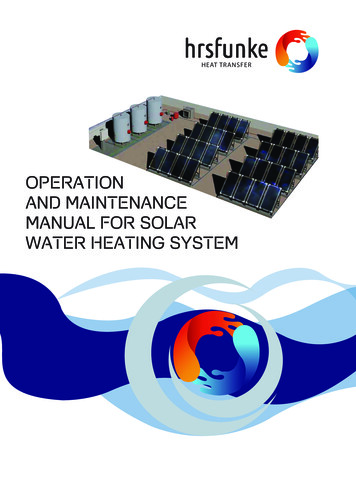
Water Quality Monitoring System Design2.0 HYDROLOGIC INFORMATION SYSTEM (HIS) OVERVIEW2.1 Hydrology and the Water CycleThe water cycle, or hydrologic cycle, is thecirculation of water through the atmosphere, land,ground, riverine network and oceans (Figure 1).Moisture in the atmosphere condenses, fallingto the Earth’s surface as rain, snow and sleet orcondensing from fog drip and dew. Precipitationhitting the surface of condensation ponds runs offover land or infiltrates into the ground. Portionsof the ponded water and runoff evaporate andinfiltrated water evaporates or is transpired byplants back into the atmosphere (the process iscollectively referred to as evapotranspiration).Excess water enters the riverine systems of streams,lakes and rivers (surface water system), or infiltratesthrough the unsaturated groundwater zone into thesaturated groundwater zone (groundwater systems).In both systems, water travels “downstream”towards the oceans with the two systemsexchanging water in the process. In addition,people influence the water flow toward the oceansthrough diverting, damming, pumping, channelizingand consuming to support human needs suchas irrigation, domestic, commercial, municipal,industrial, energy production and navigation uses.Unconsumed and post-consumed water by humansre-enters the groundwater and surface watersystems in its travels. Water that has neither beenlost to evapotranspiration, nor stored in reservoirs,glaciers or aquifers, nor consumed by people entersthe ocean where it again is evaporated to supplythe atmospheric moisture that will ultimatelyprecipitate or condense. Throughout the process,water quantity and chemistry are changing.The science of understanding the occurrence,distribution, movement and properties of waterand its relationship with the environment is calledhydrology.Figure 1. Graphical depiction of the water cycle. Source: U. S. Geological SurveySource: U. S. Geological Survey (2015)IISD.org3
Water Quality Monitoring System DesignHuman well-being relies on water and theecosystems that it supports. The delivery, timing,storage and quality of water in a watershedinfluence the social, economic and ecologicalsystems that influence people's lives. Watermanagers are concerned with the quantity andquality of water as it moves through the cycle andhow policies, projects and infrastructure operationscan be operated to improve human well-being. Akey component of managing water is characterizingthe flow, storage and quality of the water within thebasin. Better understanding of a basin’s hydrologiccycle, as well as human and ecosystem use of water,greatly improves planning efforts; reduces risk andcost in the design and operation of infrastructure(e.g., reservoirs); decreases damages associatedwith flooding and drought; and improves policiesfor managing the water resources in a basin.The fundamental method for understanding thehydrologic cycle in a basin is monitoring waterquantity and the quality of its movement in thegroundwater and surface water systems. Thus, aneffective monitoring system is key to better watermanagement in a basin.and disseminate the data. Failure to address eitherelement in developing a monitoring system will limitthe success of implementing an HIS. This reportfocuses on surface water, groundwater and waterquality monitoring in distinct sections.2.2 HIS DefinitionA robust HIS network provides information to givewater managers and interested stakeholders ameans of monitoring, evaluating and analyzing thehydrologic system upon which ecological, social andeconomic systems rely. HIS data support a widegamut of water projects, from long-term planningto infrastructure design to real-time operationsto research (Table 1). Incorporating spatial andtemporal data into water projects increases thepredictive accuracy, lowers the risk, provides greatereconomic benefit (i.e., more efficient designs,operations and water use), reduces potential forconflict and provides the foundation for betterdecisions (World Bank, 2015). Continuous collectedfield measurements are evaluated either as isor statistically converted (e.g., maximum values,minimum, frequency of occurrence, trends,seasonality), depending on the question beingaddressed and the analysis being performed.A Hydrologic Information System (HIS) is asystem for measuring, processing, storing anddisseminating interlinked aspects of watersheddata including the quantity and quality ofclimate (hydro-meteorological, e.g., precipitation,evapotranspiration), surface water (hydrological)and groundwater (hydrogeological). Elements of anHIS include the physical infrastructure and humanresources (United Nations environment Programme[UNEP] & World Health Organization [WHO], 1996).The physical infrastructure includes observationnetworks; laboratories; data communicationsystems and data storage; and processing centresequipped with databases and tools for data entry,validation, analysis, retrieval and dissemination(UNEP & WHO, 1996). Human resources are welltrained, dedicated staff supporting the HIS with avariety of skills to observe, validate, process, analyze2.3 HIS Role in Water ManagementWatershed management involves managing theland, water systems and freshwater ecosystemsto protect and improve water quality and quantityfor supporting the ecological, social and economicsystems within a watershed. Water-relateddecision-makers are concerned with ensuringthat these benefits are maintained and optimizedagainst other uses and over time. A critical needfor good watershed management is comprehensivedata, characterizing the hydrologic system andits main components and links. An HIS is a criticalcomponent of watershed management anddecision-making, as it compiles and providesthe data and information necessary for informeddecision-making, monitors the impacts of programsand other actions, and helps us understand trendsand in watershed and component systems.IISD.org4
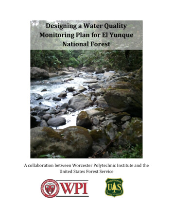
Water Quality Monitoring System DesignTable 1. Priority of hydrologic and water quality monitoring data in water projects.Source: WMO (2008)2.4 Developing a Monitoring NetworkA key component of an HIS is the monitoringnetwork, which involves collection of fieldmeasurements. The fundamental factorsinfluencing the design of a monitoring networkis the monitoring objectives (present and future),physical characteristics of the systems andresources available (human and monetary) (UNEP& WHO, 1996). The first step in developing an HISis to determine the purpose of the monitoring. Forexample, is the monitoring network supposed tocharacterize baseline conditions in a watershedover time, ascertain the impacts of climate changeon human development, monitor the impactof a certain project on the water system or acombination of all the purposes. Based on thespecific objectives and timescale, what is to besampled, where, how often and how accurate thesample collection can be determined. Choosingthe appropriate scale and scope depends on themonitoring objectives and budgetary/resourceconstraints. Costs associated with establishingand operating a monitoring network include landacquisition, station construction, equipmentprocurement and installation, station operation,IISD.org5
Water Quality Monitoring System Designmaintenance, data processing and storage, andstaffing of field stations and data centres. Oncethe relationship between the chosen effectivenessmeasure and costs has been established, theoptimal network can be found.Monitoring objectives influence the density ofmonitoring stations and the duration of operations.Monitoring network types can be classified asbaseline, management and project. Baseline: A low network density of monitoringstations and a long period of operationscharacterize baseline networks in order toprovide a synoptic data set. Management: Management networks addresswater resource issues by supplementing thebaseline network with increased monitoringstations that are subject to alteration (stationlocations and variables) to address changingconditions in management of resources. Project: Project networks are supplemental tobaseline and management networks and areinstalled to assist in planning, operating andmonitoring conditions in and around a projector study. The latter would be appropriatefor developing, operating and assessing thechanges associated with a mine.Monitoring networks are not static and thus needto be evaluated and altered periodically (WorldMeteorological Organization [WMO], 1994).Objectives need to be re-evaluated and data needto be reviewed to determine if they are adequatelycapturing the spatio-temporal variability formanaging resources. That said, the long-termbaseline network should be maintained with minimalchange or disruption in order to provide a long-termrecord of hydro-meteorological conditions.2.5 Integration of Monitoring NetworksAs most organizations monitor only a limited rangeof the hydrologic cycle, a monitoring networkto support water resource management shouldhave a coordinated approach in measuring thehydro-meteorological, surface water, groundwaterand water quality conditions. The baseline hydrometeorological monitoring network shouldsupport the surface water and groundwatermonitoring networks in determining rainfall-runoffcomputations and groundwater recharge areas,respectively. For baseline surface water monitoringnetworks, spatial coverage of water level anddischarge stations should have sufficient spatialcoverage for the computation of catchment waterbudgets. Similar water balance and resourceassessment considerations also apply to thegroundwater and water quality monitoring networks.Organizational integration of the networks impliesthat the networks are complementary and thata regular exchange of field data occurs betweenagencies to produce authenticated, high-qualitydata.A typical example is the hypothetical one depictedin Figure 1, where water managers in the basinare facing a number of watershed managementchallenges that involve groundwater and surfacewater quantity and quality issues (World Bank,2015). These issues include flooding near thecity; water allocation between the municipalities,irrigation, industry and ecological sectors;groundwater sustainability for industrial expansionin the proximity of the city; and optimization ofreservoir operations to prevent flooding and satisfydownstream water demand requirements duringperiods of low rainfall. The type of monitoringequipment presented in the example is explained insubsequent chapters.In order to make water allocation decisions, aseries of hydro-meteorological, surface water andgroundwater networks have been developed tounderstand these issues in space and over time.In this example, various departments within thecentral government have established baselinemonitoring networks for the entire country with alimited number of monitoring stations loca
system accurately in turn relies on monitoring and reporting of system parameters. To provide guidance on effective and high-quality monitoring, this report focuses on the details of water monitoring, including issues such as monitoring system design, site selection, monitoring frequency, reporting, etc.