Transcription
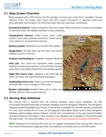
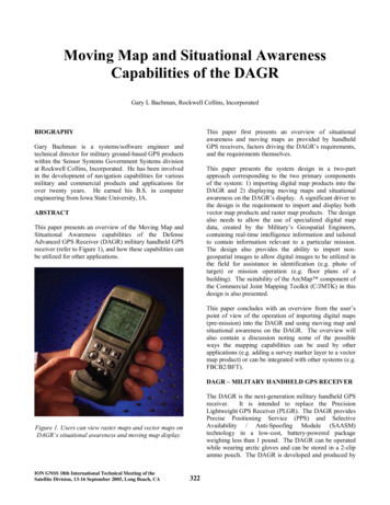
Moving Map and Situational AwarenessCapabilities of the DAGRGary L Bachman, Rockwell Collins, IncorporatedThis paper first presents an overview of situationalawareness and moving maps as provided by handheldGPS receivers, factors driving the DAGR’s requirements,and the requirements themselves.BIOGRAPHYGary Bachman is a systems/software engineer andtechnical director for military ground-based GPS productswithin the Sensor Systems Government Systems divisionat Rockwell Collins, Incorporated. He has been involvedin the development of navigation capabilities for variousmilitary and commercial products and applications forover twenty years. He earned his B.S. in computerengineering from Iowa State University, IA.This paper presents the system design in a two-partapproach corresponding to the two primary componentsof the system: 1) importing digital map products into theDAGR and 2) displaying moving maps and situationalawareness on the DAGR’s display. A significant driver tothe design is the requirement to import and display bothvector map products and raster map products. The designalso needs to allow the use of specialized digital mapdata, created by the Military’s Geospatial Engineers,containing real-time intelligence information and tailoredto contain information relevant to a particular mission.The design also provides the ability to import nongeospatial images to allow digital images to be utilized inthe field for assistance in identification (e.g. photo oftarget) or mission operation (e.g. floor plans of abuilding). The suitability of the ArcMap component ofthe Commercial Joint Mapping Toolkit (C/JMTK) in thisdesign is also presented.ABSTRACTThis paper presents an overview of the Moving Map andSituational Awareness capabilities of the DefenseAdvanced GPS Receiver (DAGR) military handheld GPSreceiver (refer to Figure 1), and how these capabilities canbe utilized for other applications.This paper concludes with an overview from the user’spoint of view of the operation of importing digital maps(pre-mission) into the DAGR and using moving map andsituational awareness on the DAGR. The overview willalso contain a discussion noting some of the possibleways the mapping capabilities can be used by otherapplications (e.g. adding a survey marker layer to a vectormap product) or can be integrated with other systems (e.g.FBCB2/BFT).DAGR – MILITARY HANDHELD GPS RECEIVERThe DAGR is the next-generation military handheld GPSreceiver.It is intended to replace the PrecisionLightweight GPS Receiver (PLGR). The DAGR providesPrecise Positioning Service (PPS) and SelectiveAvailability / Anti-Spoofing Module (SAASM)technology in a low-cost, battery-powered packageweighing less than 1 pound. The DAGR can be operatedwhile wearing arctic gloves and can be stored in a 2-clipammo pouch. The DAGR is developed and produced byFigure 1. Users can view raster maps and vector maps onDAGR’s situational awareness and moving map display.ION GNSS 18th International Technical Meeting of theSatellite Division, 13-16 September 2005, Long Beach, CA322
Rockwell Collins, Incorporated (RCI) in cooperation withthe United States Air Force GPS Joint Program Office.Track history can be used to determine if the user hasfollowed the desired search grid pattern.The DAGR is intended to reduce the current usage ofcommercial handheld GPS receivers in the Military,especially where the vulnerabilities of commercialreceivers [1] increase the risk of loss-of-life.Toaccomplish this, the DAGR provides many of the userfriendly features found on commercial handheld GPSreceivers such as graphical displays, situational awarenessand moving maps. In addition, the DAGR providesseveral unique military-driven functions such as jammerfinder, fire support and artillery pointing assistance (thesemilitary functions will not be covered by this paper).An alert can be a point, line or area of special interest tothe user (refer to Figure 2). The DAGR displays an “alertmessage” to the user when the user gets too close or toofar from an alert point, when the user crosses an alert line,or when the user enters or leaves an alert area. Alerts canbe used to alert the user when coming too close to aknown hostile location, or to alert the user when leaving a“safe zone”. Waypoints can be used to define the alertboundaries.SITUATIONAL AWARENESS OVERVIEWSituational awareness can take many forms. In the caseof the DAGR and many commercial receivers, situationalawareness is provided to the user via a graphical displayshowing the user’s current location with respect to otherfeatures such as user-entered waypoints, routes, trackhistory, search grids and alerts as well as featuresprovided from a digital map. A “you are here” symbol isused to denote the user’s current location. A situationalawareness and moving map display has become anessential tool for the military user.Figure 2. Users can easily see themselves (circle in thecenter) inside a hostile alert area and measure thedistance from themselves to an exit point.Navigating to a waypoint is a function common to mostall makes of GPS receivers. Navigation information canbe displayed as numbers (e.g. range and azimuth to awaypoint) or graphically using a pointer or directionalline to follow. DAGR provides numerical and graphicalmethods, with the directional line being used on thesituational awareness displays. The navigation line showsa direct path (as the crow flies) from user to the waypoint.The user can easily view obstacles along the path on thesituational awareness display (e.g. hostile locations, alerts,rivers).Waypoints are locations having special interest to the usersuch as home, camp, points along the way, or a point ofinterest. Waypoints can also be used to note the locationof known threats. The DAGR allows waypoints to becreated in several ways: 1) hand entry, 2) scroll and pointusing situation awareness displays, 3) marking user’scurrent location, 4) calculating a point from user’s currentlocation using range and azimuth either manually or froma Laser Range Finder device, 5) from track history orautomatic-marking, and 6) from other devices via itsserial ports.MOVING MAP OVERVIEWA route is simply a series of waypoints which, whentraveled, provide a path to get from point A to point B.Routes of two or more waypoints are used to create apreferred path, which may be used to avoid hostileregions or large obstacles.Moving maps are a natural addition to a situationalawareness display. The user “you are here” symbol isshown at the center of the display and the map is movedbehind the symbol as the user moves. The addition ofroads, rivers, populated areas and other geographicalinformation provide additional information to the user,increasing situational awareness. Maps can be enhancedor tailored to meet specific needs of a user such as addingmilitary intelligence information.Track history (or bread crumb trail) is a record of whereyou have been. The DAGR can be configured to logcurrent location (or drop a bread crumb) based on a userentered time period or distance traveled. Track historycan be turned into a series of waypoints to create a route.The created route can then be used as a “path back home”.REQUIREMENT DRIVERSA search grid is a path/pattern used to search forsomething. The situational awareness display shows theuser’s location with respect to the desired search grid.ION GNSS 18th International Technical Meeting of theSatellite Division, 13-16 September 2005, Long Beach, CAThe commercial GPS receiver products have driven manyof the situational awareness and moving map capabilitieswhile others were driven by military user needs. Thecommercial products also drive the user interface323
consequences if not drawn correctly; “Which side of thedemilitarized zone am I really on?”expectations for DAGR. These expectations translate intoan “easy-to-use” requirement where explicit words arelacking in defining the expectations.The DAGR allows the user to dictate the line drawingmethods by allowing the user to define features as havingeither Rhumb Line or Great Circle properties. A linedrawn using a Great Circle algorithm would provide theshortest distance to travel between the two points, andaccount for the curvature of the earth. A line drawn usinga Rhumb Line algorithm may not be the shortest distancebetween the points, but would have a constant azimuth(direction of travel). This concept can be easily viewedby placing a string between Philadelphia and Madrid on aworld globe (refer to Figure 3). The string represents thegreat circle path between these cities. Both cities lie atabout 40 N latitude; the 40 N latitude line represents theRhumb Line path. The Rhumb Line path has a constanteast/west path; while the Great Circle path changes from asomewhat north direction, to east/west, then to somewhatsouth.User-friendliness is subjective, and a user’s preference isusually biased by experience with other similar devices.The military users have become familiar with thecommercial GPS receivers and expect to be able to easilyuse the DAGR with little or no training. Fortunately,there is a lot of similarity in situational awareness andmoving map displays of the various commercial GPSreceivers. Learning to operate the DAGR’s situationalawareness and moving map displays has beenaccomplished by many without any training other thantheir experience with their personal commercial GPSreceivers.USER REQUIREMENTSThe features listed above (under Situational AwarenessOverview) provide the list of items the military user needsto have displayed on a situational awareness display. Theneed for some of those features, such as alerts and searchgrids, is stronger for the military user than the ordinarycivilian user. All of these features, including movingmaps, are provided by the DAGR.The symbology used to represent features on the DAGR’ssituational awareness display needs to be consistent withother military symbology. Inconsistent symbology cancause misinterpretations which can lead to severeconsequences. Waypoints and other non-map featurescomply with MIL-STD-2525 DoD Interface Standard,Common Warfighting Symbology [2] and FM 101-5-1Operational Terms and Graphics [3]. Map featuresymbology (associated with vector maps) complies withMIL-DTL-89045 [4].Figure 3. The difference between a Great Circle path(green) and a Rhumb Line path (red) can easily be seenbetween Philadelphia and Madrid.One of the limitations of GPS impacting situationalawareness is the continuous availability a GPS solution.A GPS solution may not be possible if satellite signals areobscured by buildings, terrain or other objects. The userneeds to be able to look at the display and quickly discernif “you are here” is really a “you were here” last knownlocation. The DAGR flashes the current location symbolwhen the DAGR’s computed GPS solution is old, anddisplays the time since the last computed GPS solution.The estimated position error is also displayed to the user.References, like those on any map, are needed by the userto comprehend what is being displayed. Which directionis north? What direction am I going? What is the scale?The direction is provided by a north indicator symbol onthe DAGR’s situational awareness display. The user isalso allowed to select between four display rotationschemes: 1) north-up (top of the display is north), 2)track-up (map rotates to show what is ahead at the top ofthe display), 3) course-up (map rotates to show desirednavigation course at the top of the display, and 4) theoperator can enter a desired fixed rotation. The north-uprotation is further defined by the user’s selected northreference: true north, magnetic north or grid north. TheDAGR also displays the map scale.In addition to what is displayed, zooming is essential tosituational awareness. Zooming allows the user to “zoomin” to view the details of a city block or “zoom out” toview the major infrastructures of a city. The DAGR’ssituational awareness display allows the user to zoomfrom a scale of 50m (400m across the width of theDAGR’s display) to 800km. This capability provides theuser with maximum ability to view the closest features (orknown threats) by zooming in and other features that arein the distance by zooming out. Feature clutter, caused byAll of the situational awareness objects are taken toanother level for the military user who is concerned withavoiding loss of life. Simple things like drawing a routeline or alert line between two waypoints can have severeION GNSS 18th International Technical Meeting of theSatellite Division, 13-16 September 2005, Long Beach, CA324
The military sometimes uses commercially available mapdata, but often develops their own map data or enhancescommercial map data with military information. Thisinformation, called overlays or annotations, can rangefrom simple directions (or highlights) to blue/red forcepositions and other intelligence information gathered fromother systems. The military user needs all of these typesof digital maps, including commercially available mapsand map overlays to perform their mission effectively.Current technology used in handheld GPS receiversimposes some limits on the user, and reduces the types ofmaps supported to those which are two-dimensionalvector and raster maps. Three-dimensional and flythrough capabilities are not provided by the DAGRtoo many features being displayed, inhibits situationalawareness.The zooming capability has to beaccompanied by automatic and user selected filtering offeatures when zooming in and out. The user needs to beable to select the detail level of the display (i.e. selectwhich features are important) to reduce (or increase) theinformation being displayed.Scrolling (or panning) goes along with zooming inallowing the user to view the nearest features or threats.The user can zoom in to view the nearest details andscroll the map in any direction to view adjacent features.This capability is useful in previewing the features thatwill be encountered along the planned route or navigationpath.In general, scrolling can be accomplished with or withoutusing a cursor. The DAGR uses a cursor to allow the userto “point” to features and obtain additional informationsuch as its location. Additional information can be storedwith the features such as text describing the feature inmore detail (e.g. what is the name of the road and whatkind of surface does it have). Information can also beobtained by comparing the location of the feature to theuser’s location, such as range and azimuth (and slantrange and elevation angle when elevation data is availablefor the feature).Military users often need to quickly change between unitsof measure, references or coordinate systems whencommunicating and coordinating activities with others.The DAGR provides quick methods to perform theseactions.The military user also needs to be prepared to operate atall locations around the world.DAGR providessituational awareness (excluding maps) in Polar Regions(an area commercial GPS receivers often do not support).The Polar Regions drive additional requirements such asthe need to be operated while wearing arctic gloves andbeing operated at temperatures that will freeze and crackordinary displays (-32 C, -25 F).MAP CREATION, DISTRIBUTION AND LOADINGREQUIREMENTSFigure 4. The Army’s Geospatial Support Teams utilize awide variety of map sources and intelligence informationto generate mission specific hard copy and digitalproducts [5].Most commercial GPS receivers having moving mapcapabilities provide a PC application to load (or export)maps into their receivers. Current technology limits theamount of map information that can be loaded into ahandheld GPS receiver. The PC application allows theuser to select one or more small areas of interest from alarger map (perhaps the entire United States) and load thearea(s) into the receiver. These PC applications are oftenbundled with map data produced/tailored for a specificreceiver or manufacturer of receivers, and do not allowusage of other sources of map data.ION GNSS 18th International Technical Meeting of theSatellite Division, 13-16 September 2005, Long Beach, CAThe geospatial support teams create digital map productsto meet specific mission needs (refer to Figure 4). Oncecreated, the maps are distributed to users as hard copy anddigital products. The digital products can be utilized bythe DAGR user after geospatially trained personnelprocess the digital products for export to the DAGR (e.g.selecting one or more areas of interest from the largermap product).325
Non-geospatially trained personnel need to be able to loadthe maps into the DAGR without using the complexmapping software. An easy-to-use map loading PCapplication is provided to load a set of maps (map set)into the DAGR.Some military operations require forces to travel largedistances, stopping only long enough to refuel and obtainthe essentials. These stops provide an opportunity to loadmaps for the next segment of the mission. Loading a setof maps into the DAGR must be completed within thetime of the planned stop, which may be as short as 10minutes.The military is also very concerned with InformationAssurance. An altered map could be very detrimental to amission. Whether accidental or intentional, the mapsneed protection against tampering.Figure 5. The GMT add-in to ArcMap allows the userto select map regions, and export the regions to the GMLapplication for subsequent loading into the DAGR.Almost any two-dimensional geospatial image that can beloaded into ArcMap can be exported to the DAGR as araster map. This includes the vast library of the military’sraster maps, imagery (satellite photographs) and scannedpaper maps. The GPS Map Toolkit (GMT) supportsdigital raster map products such as raster map formatsconforming to MIL-STD-2411 [7]: geospatial productsCompressed ARC Digitized Raster Graphics (CADRG)and Controlled Image Base (CIB), and GeoreferencedImagery using Tagged-Image File Format (GeoTIFF).The Military Analyst (or Military Extensions) portion ofC/JMTK is needed by ArcMap to process the militaryraster map products.SYSTEM DESIGN – MAP SET CREATIONThe system requirements presented many challenges tothe development team. The two biggest challenges were1) how to allow the users to utilize the wealth of existingmilitary and commercial digital map products, and 2)integrating moving maps onto the DAGR’s situationalawareness displays.Several digital map visualization tools are available andare being used by the Military, such as FalconView, JointMapping Toolkit (JMTK) and C/JMTK. Over 500hundred visualization products are available [6]. All ofthe United States’ services are currently in transition toC/JMTK. C/JMTK also provides all of the capabilitiescurrently needed by the DAGR users, the biggest ofwhich is allowing the user to access the wealth of existingand future map data.Raster maps are not as scalable as vector maps. A rastermap is essentially an image which is a collection ofpixels. To zoom out on a raster map, adjacent pixels needto be either discarded or blended together to form a newimage. ArcMap can be used to easily rescale a map. Ituses sophisticated techniques to blend the image as it isbeing scaled. The DAGR provides a less processorintensive form of scaling by discarding pixels (whenzooming out) or duplicating pixels (when zooming in).This form of scaling can effectively provide zoomingbetween scales of 1/5x to 4x of the loaded map scale.ArcMap can be used to scale a raster map prior toexporting it to the DAGR, allowing the user to adjust themap scale to account for the DAGR’s display size.An add-in to C/JMTK’s ArcMap tool was chosen tofacilitate map creation. An add-in adds functionality to anexisting application (e.g. Microsoft Word supports addins). The add-in, called GPS Map Creator (GMC), allowsthe user to select rectangular regions of displayed mapsand export them to the DAGR (actually it is exported toanother PC application, which will be discussed shortly).From the user’s point of view, the add-in is simply twoadditional buttons on the tool bar: one to select a regionand one to export the region. Figure 5 shows a mapviewed on ArcMap with three regions selected. Theadd-in application itself is more complex. Austin InfoSystems, Incorporated (AIS) developed the GMC add-in.GMC has the complex task of determining what is beingdisplayed on ArcMap within the selected regions andprocessing the corresponding layers of information forexport. The layers could contain raster data, vector dataor annotations; each having its own unique processing.ION GNSS 18th International Technical Meeting of theSatellite Division, 13-16 September 2005, Long Beach, CAMost two-dimensional vector maps that can be loadedinto ArcMap can be exported to the DAGR as a vectormap. This includes the military’s vector maps and manycommercial databases. The GPS Map Toolkit (GMT)supports digital vector map products such as vector mapformats conforming to ESRI ’s Shape file format and326
accomplished by re-ordering the maps, deleting maps andupdating properties/names of the maps. The ordering ofthe maps is needed to facilitate the “drawing order”performed by the DAGR (i.e. an overlay needs to bedrawn after a map).MIL-STD-2407 [8]: geospatial products Vector Map(VMap) Levels 0-2 and Urban Vector Map (UVMap).The map creation software does not support maps in thePolar Regions (above 80 latitude). It only supports mapshaving a WGS-84 horizontal datum. Maps having adatum other than WGS-84 can easily be converted toWGS-84 within ArcMap .Managing a map set also includes managing the size ofthe map set. The size of each map (amount of memory itwould consume when loaded into the DAGR) is displayedalong with the space remaining, based on the DAGR’smap memory capacity (refer to Figure 6). If a user’smission takes a path that is neither east/west nornorth/south, then a patchwork of smaller rectanglescovering the area of the path would consume less mapmemory. Figure 5 shows a patchwork of three smallermaps.Annotations on raster maps and vector maps can beexported to DAGR as well. These annotation layers willbe merged into a raster map when exported to the DAGR.They will be exported as separate maps to the DAGRwhen exporting a vector map (allowing the annotationlayer to be enabled / disabled within the DAGR).The GMC application software is designed to be executedon PCs running the Microsoft Windows operatingsystem (2000 or XP) and having C/JMTK (or appropriateArcMap components) already loaded.GML map set management also includes the ability tosave and open map set files (.GMP) to and from PC mediadevices. GML encrypts the map set files to inhibitaccidental or intentional tampering.SYSTEM DESIGN – MAP SET LOADINGThere is a strong desire to separate map selection/creationand map loading for three reasons. The first reason is theconcern of the many digital map visualization tools beingused now and potentially into the future. The secondreason is the personnel distributing and loading maps intothe DAGR are not trained to use the complex digital mapvisualization tools. The third reason is the desire toseparate the target map format processing (in this case theformat required within the DAGR itself) and the mapcreation.The approach to separate map creation and map loadingresults in two applications: GPS Map Creator (GMC) tocreate the map and GPS Map Loader (GML) to load (andmanage the created maps). Together they form the GPSMap Toolkit (GMT).Figure 6. The GML PC application allows the user tomanage map sets and load them into the DAGR.GML has six primary functions: 1) process map dataexported from GMC, 2) allow the user to manage the mapset, 3) allow the user to adjust detail settings, 4) allow theuser to import non-geospatial images, 5) allow the user topreview maps and 6) format and load the map set into oneor more DAGRs.Vector maps can easily become cluttered with too manyfeatures. A feature relevant to one mission (e.g. a culvert)may not be relevant to another mission. The user canadjust the detail settings individually for each of the 300 features supported by GML. This allows the user toselect at what zoom (range scales) the feature will bedisplayed on the DAGR.The interface between GMC and GML is provided by asocket service and the exchange of information usingExtensible Markup Language (XML) formatted data. Thesocket service is installed as part of the GPS Map Toolkit(GMT) installation package. GMC uses the socketservice to export map data to GML. GML processes thedata based on its source.Non-geospatial images may be important to a mission aswell. Floor plans of a building or photos of a target canbe loaded into the DAGR instead of being hand-carried inhard copy form. GML allows the operator to import anyMicrosoft Windows 16 Color bitmap file formattedimage into the map set. These images can then be loadedinto the DAGR and viewed on its display. GML allowsthe user to preview the images, as they would appear onthe DAGR, after it converts them to four color gray scale.GML allows the user to manage the map set.Manipulation of the maps within the map set isION GNSS 18th International Technical Meeting of theSatellite Division, 13-16 September 2005, Long Beach, CA327
GML also embeds the vector map feature symbols (icons)within the map set itself. This eliminates the need toupdate the DAGR software when features are added ormodified; only the GML application is required tochange.Previewing the maps as they will be seen on the DAGR isvery important since the DAGR’s display is significantlydifferent from a PC’s display. The DAGR’s display issmaller (2.3” x 1.8”), has fewer pixels (160w x 120h) andhas fewer colors (four color gray scale) than a PC. Thesize of the display restricts the amount of map the usercan view; the information on the map can be adjusted bythe GMC operator and re-exported to GML to provideoptimal viewing on the DAGR. Symbology for featureson the map is guided by MIL-DTL-89045 [4] andadjusted to accommodate the display. Raster mapsexported by GMC are converted to four color gray scaleas well. The operator can expand the preview pane size toview an area larger than the DAGR’s display, and is givenan option to view the DAGR’s display coverage (refer toFigure 7).The GML application software is designed to be executedon PCs running the Microsoft Windows operatingsystem (2000 or XP); it does not require C/JMTK to beinstalled.SYSTEM DESIGN – DISPLAY PROJECTIONThe first question asked when graphically displayingsituational features or maps is “How do I correctly displaythe spatial relationships?” Choosing an appropriate mapprojection becomes a choice between processorconsumption, distortion and the user’s need to trust thedisplayed information.All map projections result in distortion to some degree.Information perceived as incorrect by the user can lead tofrustration and increased mental work load. Sincedistortion becomes more visible as the user zooms out(increasing the range scale), the user may question thevalidity of the display. Lines the user expects to bestraight being displayed with curvature will cause the userto question the display.The DAGR utilizes two projections: the EquirectangularProjection and the Gnomonic Projection.TheEquirectangular Projection is used to display movingmaps in non-Polar Regions (below 80 latitude). TheGnomonic Projection is used in Polar Regions.Figure 7. The user can use GML to preview vector maps,raster maps and images as they would appear on theDAGR. The user can select a preview option to showDAGR’s display coverage.The Equirectangular Projection [9] [10] (also known asEquidistant Cylindrical) has been historically chosen fordigital plotting (raster maps). It consumes very littleprocessor, and is the military standard for raster maps ofnon-polar regions [11]. Both Great Circles and RhumbLines may appear to be curved over great distances. Thisprojection is not suitable for use in Polar Regions.Loading (exporting) a map set into a DAGR is supportedby GML, as well as importing a map set from a DAGR.Manipulation of individual maps within the DAGR is notallowed as it impacts rendering speed, logistics of map setconfiguration in the battlefield and creates map memoryfragmentation issues. Fast loading capabilities (32Mbytesin 15 minutes) and multiple load capabilities (up to 16DAGRs at a time) provide an effective means of loading.In addition, map sets can be transferred from one DAGRto another DAGR. The map sets are encrypted duringimport, export and transfer to inhibit accidental orintentional tampering.Map sets are formatted by GML to reduce the timeuser waits to see a map. The formatting is tuned tomemory, graphic services and processor withinDAGR to increase rendering speeds (time it takesDAGR to draw/display the map).ION GNSS 18th International Technical Meeting of theSatellite Division, 13-16 September 2005, Long Beach, CAthethethetheFigure 8. The Gnomonic Projection can be used in thePolar Regions.328
introduced. Pre-processing the area into polygons that areless processor intensive is performed by the GPS MapLoader (GML) PC application as part of its formattingprocess. An area feature can also be represented as morethan one polygon.The Gnomonic Projection [9] [10] can be used around theentire earth (including the Polar Regions) using the centerof the display (user’s location) as the center of theprojection. Azimuths and distances to features from theuser’s location are true; the user can quickly estimatethese values using the references provided on the display.Great Circle lines are straight on this projection. ARhumb Line may appear to be curved over large distancesor in polar-regions. Azimuths and distances betweenfeatures are distorted, but not to any great extent in nonpolar regions. Processor consumption is reasonable if thesphere formulas are utilized.Complex alerts have circular or polygon shapes. Th
of the system: 1) importing digital map products into the DAGR and 2) displaying moving maps and situational awareness on the DAGR's display. A significant driver to the design is the requirement to import and display both vector map products and raster map products. The design also needs to allow the use of specialized digital map