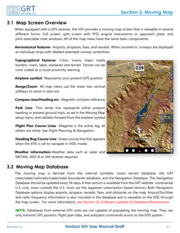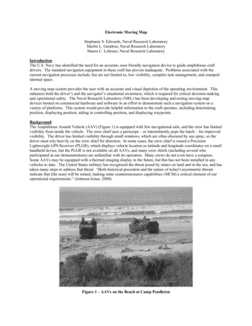
Transcription
2120VNOVFRMOVING MAP DEVICESSAFNSEETY SESS29
CAA / November 2021YOUR SAFETY SENSE LEAFLET FOR:VFR ‘MOVING MAP’ DEVICESThe use of VFR ‘Moving Map’ devices is now commonplace in General Aviation.Supported by the Global Navigation Satellite Systems (GNSS), these deviceshave considerably enhanced the process of flight planning and execution forGA pilots. Moving Maps encompass a range of electronic navigation solutions,including portable VFR GNSS devices and applications running on smart phonesor tablets.Viewing the aircraft’s position in real time mitigates a variety of risks comparedto the sole use of traditional VFR navigation techniques. However, like anytechnology or device, additional hazards may be generated if they are notused correctly.There are too many different devices and applications available for theCAA to offer detailed advice on individual platforms. The purpose of thisleaflet is therefore to identify minimum levels of proficiency you shouldhave when operating Moving Map devices and advise on some of theassociated risks and issues.Safety Sense / 29 / VFR Moving Map Devices2
CAA / November 2021USE OF VFR ‘MOVING MAP’ DEVICESWhat do we mean by ‘Moving Map’ device?In this leaflet ‘VFR Moving Map’ means either a device, or software for use on a device, which may beused for the planning and/or execution of a VFR flight. The key feature is that it displays the aircraft’sposition in real time on a map format that includes relevant aeronautical information for VFR flight.These devices normally fall into three categories:Tablet or smartphone devicesExperience has shown that consumer tablet or smart phone devices can be a safeand effective platform for applications that provide Moving Map functionality andintegration of aeronautical data.Tablet-based devices with suitable applications are likely to provide the mostversatile and cost-effective solution for the average GA pilot flying under VFR.Portable GNSS systemsDedicated portable GNSS systems provide the benefits of a platformdesigned for use in the aviation environment but may not provide regulatedaeronautical information such as weather and NOTAM. Enhancement ofsituational awareness may depend on the size of the Moving Map andhow much information can be displayed.Panel mounted devicesThe benefit for VFR flight varies a lot depending on the age and characteristicsof the installation. Many IFR devices are also capable of displaying suitable detailfor VFR flight, but users must ensure they are correctly configured to do so.Older installations with small Moving Maps or even no map at all do not providemuch situational awareness and are of limited value for VFR flight.!The options are not mutually exclusive, for example it may enhance situationalawareness to be running a VFR application on a tablet device, even if your aircrafthas a panel mounted Moving Map display.Safety Sense / 29 / VFR Moving Map Devices3
CAA / November 2021USE OF VFR ‘MOVING MAP’ DEVICESBenefitsSituational AwarenessVFR Moving Maps, when usedcorrectly, provide a significantenhancement to situationalawareness of your position,adjacent airspace, aerial sportingsites and activity areas whichmay be hazardous to aviation.Information on ad hoc aerialactivity subject to NOTAM,along with both visual and auralwarnings may also be provided.Enhanced PlanningMoving Map devices andsoftware applications also!1aid the process of flightplanning and allow routes tobe built taking into account theairspace environment to benavigated. You can incorporaterecommendations such asplanning to remain, where able,a minimum of 2 NM laterallyand 200 feet vertically from thelimits of controlled or notifiedairspace (‘Take 2’) and the useof Frequency Monitoring Codes.Some devices allow routesto be flown in a simulatormode, where the plan canbe assessed, and threats canbe identified and mitigated.NOTAM and weatherinformation are also oftenavailable from the sameplanning source and a PilotLog (PLOG) and frequencycard can be generated.Other FeaturesMany applications have otherfeatures such as the calculationof Weight & Balance, filing ofVFR Flight Plans and GeneralAviation Report (GAR) forms.When used effectively, thesetools can assist pre-flightpreparation and give more timeto focus on studying the route.In recent causal factor analysis1, the correct use of VFR Moving Map technology couldhave helped prevent 85% of analysed airspace infringements from occurring. Based onthese statistics the CAA actively encourages pilots to use VFR Moving Maps as part of theirplanning methodology, and when in flight, because they can enhance a pilot’s positionalsituational awareness and can also offer timely alerts to airspace and aviation hazards.However, Moving Map technology should not be the sole means of planning or navigation.CAP1749 - Causal Factor Analysis of Airspace Infringements in the United KingdomSafety Sense / 29 / VFR Moving Map Devices4
CAA / November 2021USE OF VFR ‘MOVING MAP’ DEVICESUnderstanding your deviceDifferent FeaturesA large proportion of GA pilotswho fly with a Moving Mapare not familiar with the useof all features or capabilitiesthe device has – taking time tounderstand the more complexfunctions will enhance thedevice’s utility.You should review theapplicable manuals and userguides. Familiarise yourselfwith the device on theground. Consider practisingon simple flights away fromsignificant airspace hazards andaccompanied by another pilot,who can look out and/or takecontrol of the aircraft if youwish to focus on the device.If the device has a simulatormode, use it to familiariseyourself with how the differentfeatures are presented inflight and how to navigatethe aeronautical informationdisplayed. Practice navigatingthe different menus and layersof information available fromthe device.Consider the reality of operatingthe device under pressureduring a flight – can you identifyrelevant information quicklyand accurately while flying theaircraft and not compromisingyour lookout?Layers of InformationBe aware of information beinghidden in layers - for example,on a paper VFR chart, glidersites with winch launchingare depicted with an encircled‘G’ and a figure in thousandsof feet above mean sea level(AMSL). This indicates thealtitude to which the cable mayextend - e.g. G/3.3 is 3,300 ft.On some Moving Map devices,information such as themaximum cable altitude may behidden. Sometimes to establishthe altitude, the depiction mustbe selected to review detailedinformation on the site.Other hidden information mayinclude radio frequencies andthe vertical extent of an ATZ orother regulated airspace.Training coursesSeveral Flight TrainingOrganisations also offertraining sessions/coursesin the use of VFR MovingMaps; not only is this an idealopportunity to learn theirfunctionality from an expertbut it might offer a refresherin flight planning techniques.Safety Sense / 29 / VFR Moving Map Devices5
CAA / November 2021UNDERSTANDING YOUR DEVICEWhen proficient you will be able to: Update the softwareand applicable aeronauticaldatabase of the device; Manage downloadabledata to the device, such asweather, NOTAM and otherlive data; Navigate seamlesslythroughout the software ofthe device, including alteringkey parameters such as mapzoom, panning of the mapand selecting informationon the route as quickly andaccurately as possible; and Plan a route and identifyairspace features andhazards on that route,including information suchas altitudes or hours ofoperation that may be hiddenwithin layers; Use the device effectivelyin any abnormal situation,for example having toreplan a route or divertdue to weather. Mount the device (ifapplicable) in a securelocation so that it is visibleand accessible but does notobstruct the aircraft controlsor visual look out; Will the screen be visible inall light conditions? Configure and use thedevice in the most effectivemanner for a particularflight, for example settingappropriate altitude layersfor the information displayedand any applicable airspacewarning parameters; How long is the battery lifeunder constant use?!Also consider: Is the device prone tooverheating when exposedto the sun? If there is provision forinflight charging, how reliableis this? Is an external aerial orreceiver needed forconsistent GNSS signal?Your primary task must be flying the aircraft. Do not allow the device to become adistraction from core tasks such as maintaining an effective visual lookout. Beingproficient with the device will help this since you will minimise the time needed tointeract with it when executing different functions.Safety Sense / 29 / VFR Moving Map Devices6
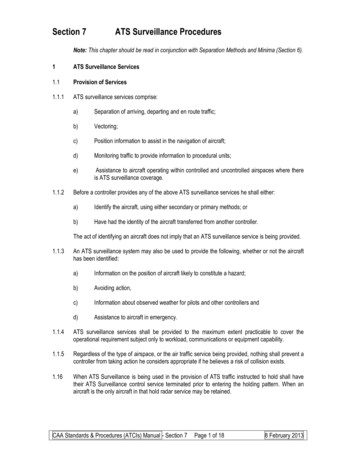
CAA / November 2021USE OF VFR ‘MOVING MAP’ DEVICESUsing your devicePreflightYou should develop a routine withthe device that suits your flyingand provides a solid foundationfor effective use while in flight.This must include ensuring theaeronautical data on the device isup to date.Download weather and NOTAMdata as appropriate. NOTAMimportant for the safety ofthe flight should be checkedagainst an official source. Ensureconfiguration of the device isoptimised for flight such asthe correct data layers for yourplanned altitude and relevantairspace warnings set.Plan the flight and configurethe device both laterally andvertically. Be aware of anycontrolled airspace or otherhazards above or below the routeand ensure they will be clearlyindicated in flight.Once in the aircraft, mount thedevice in the secure location youhave identified and ensure it isclear of flight controls and notobstructing visual lookout.Do most of the configurationbefore starting engines andminimize interactions with thedevice during taxiing, takeoff, andlanding. If you need to interactwith the device prior to takeoff,do this at the hold while theaircraft is stationary.InflightOnce airborne and away fromthe aerodrome traffic circuit,do a sense check against thesurrounding environment –does the indicated position makesense and are you travellingin the intended direction?Eyes outsideDuring flight around 80% ofthe time you should be lookingoutside the aircraft. Familiariseyourself with what you expectto see and hear from your VFRMoving Map and/or electronicconspicuity device. This will allowyou to spend no less than 5seconds at a time with your eyeson the device or in the cockpit,giving more time to that criticalactivity of LOOKING OUT.Under VFR, the aircraft’sapproximate flight attitudeshould be set visually by externalreference rather than by theinstruments in the cockpit.Time with eyes inside the aircraftshould be spent scanning theaircraft’s instruments and theMoving Map display.If a course adjustment is needed,fly the appropriate heading onthe aircraft’s direction indicatorand check the track againstthe Moving Map. Avoid ‘trackcrawling’ or chasing the ‘magentaline’ with frequently changingheadings – it is better to flysteady headings and periodicallycorrect as required.If you need to do a longertask (such as a reroute), breakthis down into steps that areinterspersed with looking outsideof the aircraft rather then being‘heads down’ for long periodsof time. If you have someoneelse in the aircraft, ask them toassist you with looking out ifyou are focusing on the device.Position AwarenessIf you are manoeuvring ina general area rather thanflying a route (for example onan instructional flight), keeporientation relative to groundfeatures, but periodically checkthe Moving Map display toconfirm position. If near controlledairspace, audio airspace alertswill be helpful, but ensure theyare set appropriately so that youdo not become desensitised tothem.PrioritiseWhen rerouting due to weatheror other threats, focus on themost important task first – forexample if unintentional flightin IMC is a threat, take up anapproximate flight path awayfrom danger and then sort outthe detail of the reroute once thesituation is stabilised.Safety Sense / 29 / VFR Moving Map Devices7
CAA / November 2021USE OF VFR ‘MOVING MAP’ DEVICESContingenciesLike all technology, MovingMap devices can suffererrors or even fail. Youmust consider contingencyarrangements for this.Paper Back-Upfeatures will also allow aneasier transition to using apaper chart, should the needarise. Knowing the approximatewinds aloft will also assist ifthe need to switch to deadreckoning navigation arises.The CAA recommends thata paper chart be carriedwhich is accessible, markedand folded for the relevantroute or area of operation.Reviewing a route on a paperchart prior to a flight will alsoassist with cross checkingaeronautical information againsta regulated source.During a VFR flight youshould also be periodicallychecking that ground featurescorrespond to the displayedposition on the Moving Mapdevice. Identification of groundTraditional Skills!There is a risk that paperchart reading skills sufferdecay if not used over time.It may be useful to includeperiodic refresher flightsusing conventional navigationtechniques. However, whenthis is carried out, it is goodpractice to use the VFR MovingMap as a visible back-up tomitigate any inadvertent errorsthat may lead to an airspaceinfringement or interactionwith other airspace hazards.Many devices record flighttracks, and these recordscan be a useful training aid,either when self-assessedor discussed with a FlightInstructor. The use of thisfacility should be encouragedto improve navigation skills.If you do experience any in flight failures of devices (other than simple thingslike running out of battery) or erroneous aeronautical data, you should considersubmitting a Voluntary Occurrence Report to the CAA using the same link as for anMOR aviationreporting.eu/Safety Sense / 29 / VFR Moving Map Devices8
CAA / November 2021USE OF VFR ‘MOVING MAP’ DEVICESCommon issuesThe incorrect or incomplete use of a VFR Moving Map device can be as significant as not using one.When using a Moving Map it is essential to apply effective Threat and Error Management (TEM). TEMis about mitigating relevant threats and preventing errors such that safe flight is maintained.The following is a non-exhaustive list of Threats and Errors associated with the use of VFR MovingMaps and some example mitigations for them:Threat/ ErrorSoftware:Is the software/data current?Why anissue?Your plan will be based on outdated or missing aeronautical information. Currentairspace hazards not identified. Does it need internet connectivity during planning?PotentialOutcomeExamplesPlan based on inaccurate/outdated aeronautical information. Current airspacehazards not identified.MitigationEnsure update process is understood and checked before every flight.Threat/ ErrorPlanning:Interrogation and overview of planned routeWhy anissue?It is tempting to ‘rubber band’ route plan, i.e. just plan A-B-C without looking alongthe route. Where are the waypoints and what lies between them?PotentialOutcomeExamplesRoute may be planned through, or too close to, the boundaries of notifiedairspace (in the anticipation of being able to ‘fly the magenta line’). Does the route‘Take 2’? Are any IFR waypoints/reporting points known to all airspace users or ATC(for example when announcing them on the radio)?MitigationCarefully check the route and the waypoints used. Back it up on a paper chart toenable a double check, aid situational awareness and provide a back-up should thedevice fail.Safety Sense / 29 / VFR Moving Map Devices9
CAA / November 2021COMMON ISSUESThreat/ ErrorCare of device:Prevent a failureWhy anissue?Failure of a device can have an impact on a flight ranging from nuisance to totalloss of navigation ability. Ensure you have the device with you, that it is chargedand/or you are able to charge it (without it overheating). If it is a new device, haveyou tested it and does it have a GNSS receiver? Your device holds a lot of usefulinformation for your flight - look after it!PotentialOutcomeExamplesFailure or partial failure can be a distraction, especially during critical phases offlight. An overheating device on charge could create a fire hazard.MitigationCheck the device as part of your pre-flight routine. Ensure battery is sufficientlycharged. Know how long the battery lasts under different conditions. Considerprovision for inflight charging, do you carry a spare charging lead? Have a contingencyplan for navigation if device fails - carry a paper chart and/or second device. Consideractions should the device catch fire.Threat/ ErrorOperation:Appropriate use and operationWhy anissue?You are flying an aircraft, use of these devices should be an aid. Ensure you knowwhat it is telling you (e.g. airspace warnings) and how you operate it (turning on/off features) so that you can quickly display and interpret information, enabling yourfocus to be on flying the aircraft and maintaining an effective lookout.PotentialOutcomeExamplesFixation on the device or over reliance can lead to loss of situational awareness,navigational errors and insufficient look out - will you see that other aircraft?MitigationEnsure you pre-plan and are able to navigate during critical phases of flight withoutthe use of a Moving Map. This will aid lookout and prevent issues should there bea sudden issue or failure of the device. Be familiar with all the features so that youcan quickly change display/settings if needed and avoid any “what’s it telling menow” moments.Safety Sense / 29 / VFR Moving Map Devices10
CAA / November 2021COMMON ISSUESThreat/ ErrorDevice Position:Where is the best place for it to be when in use?Why anissue?The device position can affect many things. Can it be seen or reached? Does thecharging lead reach or potentially foul the controls? Will it get a good signal/view ofthe sky from its position? Is it likely to fall on the floor/down the back of the seat?PotentialOutcomeExamplesThe device could become unusable if the positioning is wrong or may cause flightcontrol issues should it or any equipment associated with it interfere with thecontrols. Does it obscure your view/ability to lookout? Could it become a loosearticle?MitigationSpend some time on the ground positioning the device to ensure the issuesmentioned are avoided. Use a robust mount to avoid it moving once airborne.Find a location that works both with and without passengers. Is the charging leadlong enough or possibly too long such that it catches on things?Safety Sense / 29 / VFR Moving Map Devices11
CAA / November 2021USE OF VFR ‘MOVING MAP’ DEVICESElectronic ConspicuityAs well as Moving Mapdevices, there are a variety of‘electronic conspicuity’ (EC)devices available that receiveand/or broadcast informationon the position of your aircraftand other traffic in the sky.The CAA encourages theuse of EC devices, but thecapabilities, limitations andoptimal techniques for usemust be understood.See and AvoidThe visual look-out shouldremain the numberone priority for conflictidentification and mitigation.!The CAA recommends thatinformation from an ECdevice be used to aid visualacquisition of other traffic,rather than avoiding traffic bydirect reference to the device.At the most basic level, aircraftequipped with an EC devicesignal their presence to otherairspace users which may insome cases be displayed on theMoving Map device; this turnsthe ‘see and avoid’ concept into‘see, BE SEEN, and avoid’.Many of the risks and issuesaround integrating an EC deviceinto your flying are similar tothat of using a Moving Map,indeed often the EC displayand the Moving Map are onthe same platform.Different SystemsIt is important to understandthe limitations of your ECdevice. This would includeknowing which signals can betransmitted/received and rangeor position limitations.Your device might not be ableto receive electronic informationfrom non-compatible devices.Although you might haveacquired a target electronically,do not assume that nearbypilots have seen you as well.There is a large diversity of ECdevices on the market withvarying reliability of positionsources and informationaccuracy. Understanding thereliability, quality of informationand overall limitations of ECdevices can be complex.For more information see caa.co.uk/ecSafety Sense / 29 / VFR Moving Map Devices12
CAA / November 2021USE OF VFR ‘MOVING MAP’ DEVICESData IntegrityNATS AIS is the authorised source of UK aeronautical information provided on behalf of, and regulatedby, the CAA.It is important that users are aware of the integrity of the information that they receive from 3rd PartyService Providers. Under current UK legislation there are no regulatory requirements in place for thirdparty providers that redistribute or re-package aeronautical information from the UK AIP.Moving Map applications and devices are not regulated by the CAA. Pilots should be aware that thedepiction of aeronautical information on VFR Moving Maps may not be complete and will likely bedifferent from the UK Aeronautical Information products accessed via the NATS AIS website, such asVFR charts, the UK AIP and NOTAM information.It is highly recommended that all organisations or individuals that process information sourced fromUK Aeronautical Information products apply best practices to ensure integrity, timely delivery and aform suitable for users. See CAP779: Regulation of aeronautical information management services.Find out moreThis leaflet does not address the airworthiness requirements for fitting or mounting devices in aircraft.When installing a device in an aircraft or mounting a portable device all applicable airworthinessrequirements must be complied with – please take advice from a licensed engineer or the appropriateorganisation responsible for the airworthiness of the aircraft.Further reading is available at the European General Aviation Safety Team safety promotion leafletGA7 (Using Advanced Navigation Technology Safely).EGAST Leaflet GA7More CAA guidance on VFR flight can be found in the Skyway Code - caa.co.uk/skywaycodeSafety Sense / 29 / VFR Moving Map Devices13
USE OF VFR 'MOVING MAP' DEVICES In this leaflet 'VFR Moving Map' means either a device, or software for use on a device, which may be used for the planning and/or execution of a VFR flight. The key feature is that it displays the aircraft's position in real time on a map format that includes relevant aeronautical information for VFR .
