Transcription
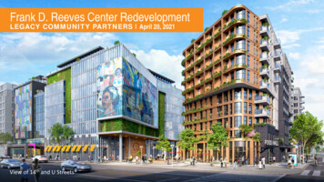
A PLAN FOR REDEVELOPMENT ONTHE YONKERS WATERFRONTAny planning should begin with a focus on a community’s strengths. What aresome of the strengths of Yonkers?1. Its waterfront location;2. The diverse community with many community-run organizations;3. Several historic community stores with locally owned businesses;4. The intergenerational structure of the existing community; and5. The community is located next to the train and water ferry systems whichcould assist with traffic concerns, and transportation needs.The key features of the current process are thedevelopment of (1) the Alexander StreetMaster Plan, (2) an Urban Renewal Plan, (3)and a Brownfield Opportunity Area Plan. Thewhole process is hinged on completing theSEQR process (a state-mandated process ofcommunity involvement and environmentalreview – see the website overview section).(1) What is a Master Plan? A MasterPlan is not a specific developmentplan, rather it provides a template orpattern for future development. Sincethe Master Plan is not a specificdevelopment proposal it would be upto the City of Yonkers to ensure thatany actual development proposalfollows the Master Plan. Overall theYonkers Master Plan focuses efforttowards economic renewal throughimproving the deteriorated waterfrontarea, transforming it from anindustrial wasteland to a residential, recreational and commercial zone. Thistransformation would be a gradual change currently anticipated to take up to tenyears. Since there are no firm development plans included in the Master Plan thefinal product could be somewhat different than what is being discussed here.(2) What are Urban Renewal Plans (URP)? URPs are long-term blueprints forimproving the economy and community of areas that meet certain definedrequirements as “blighted areas” (deteriorated neighborhood) or areas that areunderutilized.(3) What are Brownfield Opportunity Area Plans (BOA)? BOAs are state plansthat focus on cleaning up and reusing sites with contamination from prior use.Many of the riverfront towns along the Hudson and America’s older rivers haveBrownfield sites from their long industrial history.
YONKERS WATERFRONT - Describing the Site –Alexander Smith Carpet Mills were a large part of Yonkers industrial history, and lent their name to thiswaterfront development plan. (image from Yonkers village history website)The area included in the Master Plan redevelopment, the Urban Renewal and theBrownfield Opportunity is all the same. It is approximately 112 acres of waterfrontproperty in general bounded by the Hudson River on the West, the Metro-NorthRailroad lines on the East, Wells Avenue and the Westchester County sewage pumpstation for the sewage treatment plant to the south, and JFK Memorial Drive to the north.There are two city-owned parks included in the project – the waterfront JFK Marina Parkand the more inland Trevor Park, public open space areas such as a Westchester Countypark, the non-profit Beczak Environmental Education Center. In addition, the areaincludes the City of Yonkers Jail. There is also one section of property that extendsinland two blocks between Warburton Avenue and the Metro-North Railroad. The mainredevelopment area west of the Metro-North railroad tracks does not contain anyresidential uses or structures.The majority of the redevelopment area is privately owned, with some portionsowned by City of Yonkers agencies. Much of the project area is developed ascommercial or industrial uses or has been cleared of development and is idle or usedfor surface parking and equipment storage. THE PLAN SITE BY THE NUMBERS153 acres of property in total but only 112 land acres with the balance of 41 acresbeing in the Hudson River underwaterArea is a long skinny strip of land - 1.3 miles from end to end (North to South)and has a width of one-tenth to two – tenths of a mileRiverfront walkway 1 mile along the entire Alexander Street waterfrontconnecting to an existing walkway to the north and south creating a GreenwayUp to 4000 residential units ( 3752 planned with up to 4000 allowed) - in 12towers of varied height – 5 will be 16 to 30 stories high and the remainder will beless than 12 storiesExpected 9,000 new residents210,000 square feet of neighborhood retail on street level210,000 square feet of office buildings on second level1.5 parking places per residential unit or 6,828 spaces
YONKERS MASTER PLANTHE ALEXANDER STREET MASTER PLAN - A REDEVELOPMENT PLANFOR THE YONKERS WATERFRONTThe goal of the ‘Alexander Street Master Plan’ is to develop a plan to revitalize theHudson River Waterfront, a deteriorated industrial district. Many communities developMaster Plans to serve as guiding documents, or blueprints, for future development in theircommunity. The difference between a ‘Master Plan’ and an actual ‘Project Plan’ is thatthe Master Plan is just a guide or a vision for future building. A Master Plan lacks aspecific developer with a specific development plan so much of the detail of developmentis not specified, although this can vary significantly according to the Master Plan. Theactual development that occurs at a later date can very closely match the Master Plan, orit can be adjusted at the time of the project.Some of the Stated Major Planning Objectives of the Yonkers Master Plan Include:1. Economic Development: Encourage economic development that includes amixed use of the existing waterfront – residential, commercial and recreational.2. Expand Housing Opportunities: Add close to 4,000 residential housing units atvarious income levels.3. Improved Public Access to the Hudson River and Improved InternalTransportation: Open the access to the waterfront for existing Yonkersresidents, and improve movement between the newly developed waterfront andexisting Yonkers communities.4. Focus on Regional Transportation: Include existing train and ferry stops as partof the overall transportation program.5. Capitalize on important site features including protecting HeritageBuildings, and increase community parkland: Where possible protect andreuse existing heritage buildings in the waterfront area. Create additional openspace areas and enhance existing community parkland.CURRENT LAND USE IN THIS AREAFacility/Land UseAcresPercentParks32.821.4Vacant/Vehicle mmercial19.712.9Community 40.626.5TOTAL153.0100
THE EXISTINGWATERFRONT AREA:The current waterfront is mainlyindustrial, vehicle maintenanceand storage, somemanufacturing and a section ofpublic service, education andparkland. Most is privatelyowned. The following is a listof some places of interest in theproject area: The Yonkers City Jail –planned for commercialuse - restaurants andcafé; Trevor Park (passiverecreation space, athleticfields and courts) andJFK Marina Park (directriver frontage with amunicipal boat rampand seasonal docks forkayaks and small boats).Together totaling 33acres. Westchester County’sHabirshaw Park (hometo BeczakEnvironmentalEducation Center); The County’s NorthYonkers Pump Station; Yonkers Canoe Club; Former GlenwoodPower Plant designedfor residential uses andpossible small retail andrestaurant use. Riverside H.S. andHudson RiverMuseum/Trevor Park Glenwood trainstation/platform Homes for Americaproperty and waterfront(former Phelps Dodgeplant, a.k.a. the big bluecube) between Point St.and Gold St. Greyston Bakery
THE HUDSON RIVER SHORELINEProviding access to the Hudson River is an important community goal. As with manyindustrial waterfront communities, people in the community have been separated fromthe river by prior industrial land use, which has deteriorated into blighted and abandonedproperties. Linking the community to the river through a stretch of public land that willrun along the project area will benefit existing community residents as well as those whomight move into the newly renovated community. Including active recreational plans aspart of the development, such as boating, fishing piers and enhancements to the BeczakEnvironmental Center, as part of the proposed development will increase the overall useof the waterfront area and may lead to an increase in environmental knowledge andawareness.PROJECT SPECIFICSSPECIFIC STATED PROJECT GOALS INCLUDE: Create a mixed-use, active waterfront neighborhood of residences, businesses, andopen spaces; Improve public access to the Hudson River along the entire 1.3 mile waterfront ofthe proposed area; Improve and enhance existing City parks and amenities, including Trevor Park andJF Marina Park; Improve the connections between the redevelopment area and the surroundingcommunity; Improve traffic with better access and circulation within the redevelopment area,and connections to the surrounding community; Promote a walkable/bikeable community; Improve access to JFK Marina Park and provide additional boating resources; As the level of development allows, focus on public views of the Hudson River; Provide a variety of housing with convenient access to goods and services, andpublic transit; Promote environmentally sensitive design through minimizing impervious surfacesand improving habitat function; When possible consider adaptive reuse of buildings with historic significanceand/or unique features; and Provide adequate infrastructure support: for wastewater treatment, water supply,parking and roadway capacity.
HOW ARE THEY PLANNING TO ATTAIN THESE GOALS? An interconnected public walkway which is referred to here as an esplanadealong the Yonkers shoreline for almost a mile of currently inaccessible shoreline.(An esplanade is a long, open, level area, usually next to a river or large body ofwater, where people may walk without actually walking on the beach or beingaffected by the tide.) The esplanade will vary in width but will be a minimum 12ft. wide. 13 acres of newly accessible parks and plazas and riverfront esplanade added tothe 2.2 acre Habirshaw Park A residential neighborhood with connections to existing neighborhoods, thewaterfront, and Yonkers’ commercial district in order to strengthen the City’sdowntown area. Off-street parking for residences, employees, and commercial patrons and onstreet parking for visitors. Access to the water for a variety of water-dependent and water-relatedrecreational uses. View corridors from the upland community through the newly constructedbuildings to the Hudson River and the Palisades – but the buildings will be up to30 stories high – higher than is allowed under existing zoning so existing views willbe significantly reduced. Residential units close to existing train stations for transportation.URBAN RENEWAL PLAN: A Financial ToolUrban Renewal Plans are long-term plans for improving the economy and communityof areas that meet certain defined requirements as “blighted areas” (deterioratedneighborhoods) or underused areas. Urban renewal projects are undertaken as a way toeliminate the conditions of blight, often using eminent domain (see box below) as a wayto do this. Since there is no specific development plan being proposed it is unclear ifeminent domain will be involved in this project area, although the Urban Renewal Plannotes that none is contemplated. Eminent domain is an interesting tool that hasdeveloped over the years into a powerful mechanism for large-scale redevelopment plansto be successful.
RESIDENTIAL UNIT COUNTAND BUILDING HEIGHTSParcelMaximumTotal UnitsLetterResidentialBuildingHeightA(2) 30 story484Bldgs.B(2) 22 story302Bldgs.C(1) 22 story176Bldgs.D(1) 14 story105Bldg.E(1) 14 story98Bldg.F(2) 28 story608Bldgs.G(2) 24 story588Bldgs.H(2) 22 story452Bldgs.I(2) Bldgs.32820/12 storiesJ(1) 12 story101Bldg.K(1) 18 story251Bldg.L&MMaximum 325storiesN(1) 18 story234Bldg.Jailn/a0Marina n/a0TOTAL3752
Master Plans to serve as guiding documents, or blueprints, for future development in their community. The difference between a 'Master Plan' and an actual 'Project Plan' is that . service 5.0 3.3 Residential 0.5 0.3 Water 40.6 26.5 TOTAL 153.0 100 . THE EXISTING WATERFRONT AREA: The current waterfront is mainly industrial, vehicle .