Transcription
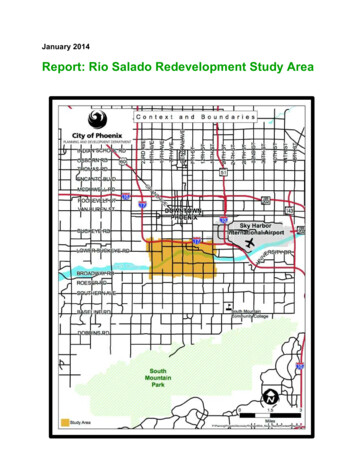
January 2014Report: Rio Salado Redevelopment Study Area
TABLE OF CONTENTSExecutive SummaryPage 2Redevelopment Area OverviewPage 3Redevelopment Area RequirementsPage 3Rio Salado Redevelopment Study AreaBoundaries and ContextHistoryPage 4Page 5RSRDA Past and Current Planning / Revitalization EffortsPage 6RSRDA OverviewDemographicsLand UseZoningPage 7Page 8Page 9Area ConditionsProperty Conditions SummaryA.R.S. Conditions SurveyPage 10Page 11Analysis and ConclusionFindingsAttachment AReport: Rio Salado Redevelopment Study Area!Page 13"!
Executive SummaryThe Mayor and City Council initiated this report to analyze and document the currentbuilding, land use and area conditions in the area referred to as the Rio SaladoRedevelopment Area (RSRDA). The Study Area is generally bounded by I-17 to thenorth, Broadway Road to the south, 19th Avenue to the west and 16th Street to the east.The primary purpose for the analysis is to evaluateconditions of the Study Area and to determine if itqualifies under Arizona State Statute as aRedevelopment Area.The primary statutory requirement for a formaldesignation of an area as a Redevelopment Area is afinding that a predominance of the property is blighted.This Report describes and documents the statutorily defined blighted conditions that,when aggregated, constitute a finding of a predominance of blight, allowing the Mayorand Council to designate the area as a Redevelopment Area.ARS § 36-1471 provides the following list of factors that,through the presence of one or more, may allow anarea to be declared as predominately blighted. Blightedproperties within the Study Area were found to meetone or more of 3 of the 9 statutory requirement options,specifically: Faulty lot layout in relation to size, adequacy,accessibility or usefulness. Unsanitary or unsafe conditions. Deterioration of site or other improvements.!!A formal declaration by the Phoenix City Council willassist in focusing City efforts to revitalize the economyin the Area, with a specific focus on economicdevelopment and quality job creation.This Report is divided into six sections which describethe history and boundaries of the Study Area, past phic, land use and zoning background in addition to a physical survey of theexisting conditions. It also describes the legal framework which authorizes the City ofPhoenix to conduct this analysis and to consider formal designation of the Study Areaas a Redevelopment Area.Report: Rio Salado Redevelopment Study Area!#!
Redevelopment Area OverviewA Redevelopment Area is designated by City Council through a formal finding ofblighted conditions within the Study Area boundaries by City Council vote. At a CityCouncil public hearing, approval of a Redevelopment Area requires adoption of aCouncil resolution that resolves/finds that both that:1. One or more slum or blighted areas exist in the municipality.2. The redevelopment of that area or areas is necessary in the interest of the publichealth, safety, morals or welfare of the residents of the municipality.The existence of blighted conditions has both a short andlong term negative affect on the City’s ability to improveeconomic development prospects and attract investmentwhich enables quality job creation. Alternatively, areasthat are well maintained and offer few obstacles toresponsible development become prime locations hment and a thriving local economy. Theseattractive areas generate more positive tax revenue tosupport critical City services.While the majority of the City of Phoenix’s 19 Redevelopment Area Plans are aimed atcatalyzing neighborhood revitalization, this Report is focused on commercial andindustrial areas that have potential for redevelopment or reinvestment.Redevelopment Area RequirementsARS § 36-1471 defines a Blighted area to be an area,other than a slum area, where sound municipal growthand the provision of housing accommodations issubstantially retarded or arrested in a predominance ofthe properties by any of the following:A. A dominance of defective or inadequate street layout.B. Faulty lot layout in relation to size, adequacy,accessibility or usefulness.!C. Unsanitary or unsafe conditions.D. Deterioration of site or other improvements.E. Diversity of ownership.F. Tax or special assessment delinquency exceeding the fair value of the land.G. Defective or unusual conditions of title.H. Improper or obsolete subdivision platting.I. The existence of conditions that endanger life or property by fire and other causes.Report: Rio Salado Redevelopment Study Area! !
Rio Salado Redevelopment Study AreaBoundaries and ContextThe Rio Salado Redevelopment Study Area is bound by 19th Avenue on the west; 16thStreet on the east; Broadway Road on the south; and Interstate 17 on the north. Thearea is located just south of Downtown Phoenix (1 mile) and just west of Sky HarborInternational Airport (1-1/2 miles to the east); and is bisected by the Salt River.The Study Area lies within two urban villages. The area north of the Salt River is theCentral City Village and the area south of the Salt River is the South Mountain Village.The area is a gateway to Downtown Phoenix, sports and cultural amenities, theemerging bio science campus and universities located downtown, Sky HarborInternational Airport, the Salt River and the Nina Mason Pulliam Audubon Center, SouthMountain Community College and South Mountain Park.Report: Rio Salado Redevelopment Study Area%
HistoryThe Study Area has a rich history of residential and mining operations that dates backseveral generations. The first known settlement of the area was created by theHohokam peoples. This ancient agricultural society farmed along the Rio Salado andmasterfully created waterways/canals. Several pioneers later settled the area in the late1800’s and at the turn of the twentieth century began acquiring thousands of acresalong the Rio Salado for farming purposes.In the early 1900’s, the Central Avenue Bridge (formerly Central Street Bridge) wasconstructed and many more homes were built in the area. One of the subdivisions builtat that time is Southgate Park Subdivision constructed in 1928, and is located at Centraland Jones avenues. Other subdivisions include Central Gardens located at CentralAvenue and Riverside Street and Frances Margaret located at 7th Avenue and IlliniStreet both built in the 1940’s.The area started to change to more commercial and industrial land uses in the 1940’sand 1950’s. The area saw a rise in the mining of sand and gravel as Phoenix boomedduring the post World War II era of the 1950’s.The area today still has many of the original residential subdivisions, as well as theaddition of commercial and industrial land uses. Seventh Avenue and Seventh Streetcontinue to provide access to downtown and South Phoenix amenities for arearesidents.Report: Rio Salado Redevelopment Study Area&
RSRDA Past and Current Planning / Revitalization EffortsThe Rio Salado Redevelopment Study Area has been the focus of past and currentplanning related projects and revitalization efforts. The following list captures theseefforts:1.2.3.4.5.6.7.8.9.South Mountain Target Area B Redevelopment PlanRio Salado Oeste PlanRio Salado Habitat Restoration ProjectRio Montana Area PlanRio Salado Interim OverlayRio Salado Beyond the Banks Area PlanDel Rio Brownfields PlanAvenida Rio Salado Study AreaSouth Central Phoenix Corridor Alternatives AnalysisP a s ta n dC u r r e n tP l a n n i n g / N e i g h b o r h o o dR e v i t a l i z a t i o n c"! c"!CouncilDistrict 8LOWER BUCKEYE RDtS a lStudy Areav eR irCouncil District Boundary23RD AVECouncilRio Salado Oeste PlanDistrict8Avenida Rio SaladoStudy AreaROESER RD7TH AVESouth Central LRT ExtensionStudyTC Ed Pastor Transit Center!15TH AVEDel Rio Brownfields Plan19TH AVERio Montana Area PlanTC!12TH STCouncilDistrict 7BROADWAY RD7TH STRio Salado Interim OverlayDistrict/ Rio Salado Beyond theBanks Area PlanCENTRAL AVESouth Phoenix Village andTarget Area B Design covery Triangle\RDA Study Report Past Current Planning Revita Council District.mxdThe South Mountain Target Area B Redevelopment Plan was adopted by thePhoenix City Council in 1980 and is bound by variable parcels north of Broadway Roadto Elwood Street, Southern Avenue to the south, 7th Avenue to the west and 24th Streetto the east. The redevelopment plan provides a framework for the stabilization,development and redevelopment of the area and to meet the Arizona Revised Statutes36-1417.The Rio Salado Oeste Plan is a combined effort between the City of Phoenix and theFederal Government to restore approximately 1,500 acres of riverine habitat throughoutReport: Rio Salado Redevelopment Study Area!'!
a 8-mile study area by returning the river channel to a more natural state by grading andterracing the channel from 19th to 83rd Avenues.The Rio Salado Habitat Restoration Project is a federally funded plan/project thatdeveloped a master plan to restore nearly five miles of native wetland and riparianhabitat along the banks of the river. The plan developed strategies to restore theblighted river corridor with the first segment of the project opening on November 5,2005.The Rio Montana Area Plan was adopted by the Phoenix City Council in 2000 and isbound by the Rio Salado to the north, South Mountain Park to the south, South CentralAvenue to the east and 27th Avenue to the west. This plan focuses on preserving therural character of the area, the natural desert and open space, encouraging pedestrianand equestrian activities, sense of community and economic development.The Rio Salado Interim Overlay District was adopted by the Phoenix City Council in2002 and is bound by the centerlines of Interstate 17/Interstate 10 on the north, 19thAvenue on the west, 32nd Street on the east and Broadway Road on the south. Theoverlay district is designed to control open, outdoor land uses and other uses in order tohave a positive impact on the Rio Salado Habitat Restoration Project and add to thelong-term value of adjacent land.The Rio Salado Beyond the Banks Area Plan was adopted by the Phoenix CityCouncil in 2003 and is bound by Interstate 17 (I-17/Maricopa Freeway) and Interstate10 (I-10) to the north, Broadway Road to the south, 32nd Street to the east and 19thAvenue to the west. The plan identifies goals and policies to guide developmentdecisions for an area beyond the banks of the Rio Salado, and to complement thePhoenix Rio Salado Habitat Restoration Project.The Del Rio Brownfields Plan was adopted by the Phoenix City Council in 2012 and isbound by 7th Avenue to the west, 16th Street to the east, Salt River (Rio Salado) to thenorth, and Broadway Road to the south. The primary objective of this plan focuses onthe environmental remediation and redevelopment of three brownfield sites.The Avenida Rio Salado Study Area Plan is a partnership between the City ofPhoenix, Arizona Department of Transportation and the Federal HighwayAdministration. The plan focuses on the study and design of increasing vehicular trafficalong Broadway Road from 7th Street to the future 202 South Mountain Freeway/67thAvenue. Construction will begin in segments during 2014.The Valley Metro South Central Phoenix Corridor Alternatives Analysis is a 24month study that evaluates several high-capacity transit options. The study area isbound by 7th Avenue on the west, 7th Street on the east, Washington Street on thenorth, and Baseline Road on the south. Options for the corridor include light rail, busrapid transit and modern streetcar, to determine which transit mode and route servesthe community best. The study is scheduled to be finalized in 2014.Report: Rio Salado Redevelopment Study Area!(!
RSRDA Overview(Note that the information in this section relates to the entire Study Area.)DemographicsAccording to the 2010 Census Summary File 1, there are 6,224 people residing in theStudy Area and 2,037 housing units. Of the 6,224 residents, 82.6% identify their race asHispanic or Latino.According to the 2007-2011 American Community Survey, the median householdincome for the Study Area is 23,056. The median housing unit value is 111,300 andthe median housing rental cost is 713.00 per month.Report: Rio Salado Redevelopment Study Area)
Land UseThe General Plan land use map below shows a mix of residential, commercial, andindustrial land uses within the Study Area. The map also shows parks/open space,public/quasi public and transportation designations in the Area. Interstate-17 is locatedalong the northern boundary of the Study Area and the Ed Pastor Transit Center islocated at the northwest corner of Central Avenue and Broadway Road. Both serve astransit corridors for the area.G e n e r a lP l a n c"! c"!Study Area3.5 to 5 du/acre5 to 10 du/acre10 to 15 du/acreStudy Area15 3.5du/acreto 5 du/acreParks/OpenSpace - Publicly5 to 10 du/acreOwnedLOWER BUCKEYE RD10 to 15 du/acreParks/Open Space - Privately15 du/acreOwnedParks/Open Space - PubliclyMixedUseOwnedParks/OpenSpace - PrivatelyMixedUse (Commercial/OwnedCommerce Park)Mixed UseMixed Use Transition ResidentialUse (Commercial3.5 Mixed- 5 du/acto Industrial/Commerce Park)MixedUseMixedUseTransitionTransition ResidentialCommerce/BusinessPark to 10 3.5 - 5 du/ac to Industrial15 du/acMixed Use TransitionCommerce/Business Park to 10 Commercial15 du/actS a lIndustrialCommercialv eR irIndustrial / Business ParkCommerceCommerce / Business tationBROADWAY RDTransportationdu/ac)Mixed Use (Commercial / 5-10du/ac)ROESER RD7TH AVE19TH AVEMixed Use (10-15 du/ac /Parks/OpenSpace)MixedUse (10-15du/ac /Parks/OpenMixed Use Space)(Commercial / 5-1015TH AVEMixed Use (10-15 du/ac /MixedUse (10-15 du/ac /Public/Quasi-Public)Public/Quasi-Public)12TH STCENTRAL AVEMixedUse(Commercial(Commercial / /15 MixedUse15 du/ac)du/ac)7TH STAVE23RD AVE23RDMixedUse (Commercial / 10-15Mixed Use (Commercial / s\Discovery Triangle\RDA Study Report GP.mxdZoningThe zoning within the study area varies from single-family and multi-family residential tocommercial, commerce park, and industrial zoning districts. There is a predominance ofindustrial zoning in the area with over 2,500 acres of land zoned A-1 (Light Industrial) orA-2 (Heavy Industrial). This translates to uses consisting of warehousing,manufacturing, storage, mining and sand and gravel pit operations.C-3C-3 P-1 *R-4C-2 *R-4A-1R-5A-1R-4R-3R-3R-4R-3 *C-2P-1 C-2 C-2R-5A-1C-2R-4R-4H-RR-4 HPR-5 SP * R-4HPC-2R-5 H-RC-2R-4 HPC-3 SP *R-3AC-1C-3R-3 HP R-3C-2C-1R-3R-4 R-5R-5R1-6C-1R-4R-5R-5A-1*C-3Z o n i n gP-1R-4R-5A-1 c"!C-2 C-2 *C-2 *C-3A-1 *CP/GCP *R-3P-1 P-1 C-3R-3C-2 *C-3C-2 *C-3C-2S-1 *C-2A-1 * c"!R-4A-1A-1 *C-3A-1C-2A-1M-R *A-2R-5A-2C-3A-1*R-3 R-3A-2R-3 R-3A-1 *R-3A-2 *R-3R-3R-3A-2 HPR-3 R-3A-2 SPA-2 SP *LOWER BUCKEYE RDA-2A-2EXPL/WVRA-1 SP * A-1A-1EXP/WVRC-3 *rReA-1R-3Study AreaA-10 to 1 du/acrePublic/Quasi-Public15 du/acreA-1 *A-1 **C-3C-3 *A-1 *A-1BROADWAY RDC-2C-3R-5R-5C-3C-1R-3IND.PK. *R-3R-4ROESER RDR-3A *R-3R-2*Report: Rio Salado Redevelopment Study Area!7TH AVEC-115TH AVE19TH AVEMixed Use AgriculturalMixed Use AgriculturalR1-6C-2C-2*R-5R-5SP R-5C-2SP *C-2 SP*R-5C-3CP/GCP *C-2C-2C-2HGT/WVRR1-6*CP/GCP *C-1R1-6*R-5MUA *R-3 HP HGT/WVRC-2C-2 *P-1P-1R-3R-5C-3R-5IND.PK.R-5C-2R-3C-2R-4C-2R-3SP *R-3C-3C-2R-5R-3A *R-5C-2IPublic/Quasi-PublicCommercialA-1 *CommercialR1-6Industrial IndustrialR1-6SP * SP */ BusinessParkCommerceCommerce/ BusinessParkR1R1-6 *R-4R-4C-3C-2C-3 SP *A-1 *A-2 *A-1A-1C-3 *C-3*C-3 *C-2C-1R-5 C-3 *CENTRAL AVE23RD AVEC-3C-3*A-13.5 to 5 du/acredu/acreR1-810 to *15 du/acre23RD AVE15 P-1C-2C-2 *R1-6R-O *A-1 *3.5 to 5 du/acreStudy AreaA-1R1-810 to *15 du/acre0 to 1 du/acreA-1C-37TH STl tS aiv12TH STA-1R-5IR1-6A-2 IND.PK.00.25C-2 PSC0.5R-4MilesR1-6P:\Planning\Projects\Discovery Triangle\RDA Study Report Zoning.mxd*!
Area ConditionsProperty Conditions SummaryQualifying factors of blight were determined through an in-person, visual analysis of theexterior of properties in the Study Area. The following describes a number of conditionsfound on a preponderance of the properties in the Study Area that qualify as blightedconditions.Fences in disrepair: Fences and screening walls must be structurally sound. Fence andwall materials must be constructed from consistent materials and must be maintainedso that they are free from deterioration.Trash/debris: Property owners are responsible for keeping their property free of junk,litter, and debris.Outside storage: Outside storage of personal property at residentially zoned propertiesis limited to the rear yard behind the primary structure only. Any building or landscapematerials for use on the property, machinery, appliances or parts/auto parts may not bevisible from beyond the boundaries of a residentially zoned property.Un-paved commercial parking: Vehicle parking surfaces on non-residential lots must befinished and maintained according to City Code specifications. Unfinished and dirtparking surfaces are not permitted.Unmaintained vegetation: Property owners are responsible for keeping their propertiesfree of weeds, tall grass, tumbleweeds, shrubs, trees, palm fronds, and other dead ordried vegetation.Inoperable vehicles: Vehicles that do not operate legally and safely cannot be placed ona property in a way that allows them to be seen from beyond the property boundaries.Report: Rio Salado Redevelopment Study Area!" !
This examination was limited to an on-site visual inspection of the property’s exteriorcondition and is not a detailed engineering or architectural analysis, nor does it includea building’s interior condition. The intent is to document obvious indications of blightedconditions within the Study Area.A.R.S. Conditions SurveyThe following conditions were found to be present in this Study Area and meet theArizona Revised Statutes requirements of Blighted conditions in a Redevelopment Area:Faulty lot layout in relation to size, adequacy, accessibility or usefulnessSeveral properties in the Study Area were observed to have faulty lot layout. Faulty lotlayout can be observed on properties that are long, narrow, or irregularly shaped, lotsthat are inadequate in size, and lots with configurations that are impractical or results inmisused or unused land.Irregularly Shaped LotNarrow LotNarrow LotIrregularly Shaped LotsReport: Rio Salado Redevelopment Study Area""
Unsanitary or unsafe conditionsUnsanitary or unsafe conditions arise when a property falls into disrepair. Theseconditions include severely cracked or uneven surfaces for pedestrians, trash/debris,vandalism/graffiti, and the existence of hazardous conditions or materials. Theseconditions were observed within the Study Area, including several former landfill sitesand a rock and gravel yDeterioration of site or other improvementsA majority of blighted properties within the Study Area demonstrate conditions of sitedeterioration. These conditions include evidence of lack of general site maintenance,unpaved commercial parking lots, deteriorated roofs, walls, fencing, lighting, fences,gates, and deteriorated parking surfaces/curbs/partial foundation concrete.Deterioration of SiteReport: Rio Salado Redevelopment Study AreaPartial Concrete Foundation!"#
Analysis and ConclusionAnalysisWhile redevelopment areas in Phoenix have historically focused on neighborhoodrevitalization, the Rio Salado Redevelopment Area is focused on economicdevelopment – namely, stimulating capital investment and fostering the growth ofemployment-generating uses. Through this strategy, the City hopes to create jobs andbusiness opportunities for the benefit of Phoenix residents, Phoenix employers and theregion’s economy. Based on this strategy, the DTDC focused on including specificareas and parcels that are positioned for investment while also meeting therequirements of the RDA statute. These include large parcels, groups of contiguousparcels with common ownership, City-owned parcels, areas suitable for commercial orindustrial development, and vacant or underutilized parcels that could accommodateemployment-generating uses. In order to protect existing neighborhoods, the DTDCalso attempted to avoid including large areas of residential properties. The resultingboundary recommended by the DTDC is depicted in Attachment A, and represents anarea with potential for job creation, capital investment and business opportunity.FindingsUpon DTDC's property analysis, a predominance of the properties within the proposedRio Salado Redevelopment Area (Attachment A) are affected by one or more of theblight conditions criteria as defined by ARS §36-1471. Based on the analysis describedin this Report, the City Council can find that a) one or more slum or blighted areas existin the municipality, and that b) the redevelopment of the area is necessary in theinterest of the public health, safety, morals and welfare of the residents of themunicipality. These findings enable the City Council to designate the Area as aRedevelopment Area.Report: Rio Salado Redevelopment Study Area!" !
Report: Rio Salado Redevelopment Study Area!"%!
The Rio Salado Redevelopment Study Area has been the focus of past and current planning related projects and revitalization efforts. The following list captures these efforts: 1. South Mountain Target Area B Redevelopment Plan 2. Rio Salado Oeste Plan 3. Rio Salado Habitat Restoration Project 4. Rio Montana Area Plan 5. Rio Salado Interim .