Transcription
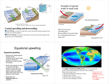
Example of regionalwinds of small scaleSea and land breezesNote on Fig. 8.11. Shows the case for southern hemisphere!Coastal upwelling and downwelling.Upwelling is caused by along shore winds, that initiate Ekman transport awayfrom the coast (N Hemisphere)Downwelling is caused by along shore winds from the south, pushing wateragainst the coast (N Hemisphere)These do not causeUpwelling andDownwelling! You need windsfor a long period and over alarge area!(disregard rial upwelling1Equatorial upwelling.*Because the meteorologicalequator (ITCZ)is moved north, the SE tradewinds an the SouthEquatorial Current straddlethe equator.* North of the equator its wateris veered to the right,south of it to the left. Thiscauses nutrient rich deepwater to enter the surfacewater which gives rise to richplankton communities.* Remember thesiliceous ooze thatunderliesthf hi h3E2AE4Equatorial upwellingFig. 8-9The major coastal upwelling areas can be found along thewestern sides (Eastern Boundary Current) of the continents.A special case is theThere are four major ones:Arabian Sea where1. Off California/Oregon (California Current)upwelling is tied to the2. Off Peru (Peru Current)monsoons.3. Off NW Africa (Canary Current)E upwelling also occurs4. Off SW Africa (Benguela Current)at the equator
Why is there upwelling alongnorth-west coast of USeven though it is not within thetrade wind system?Anticyclonic (clockwise) air flow in the high pressure system thatEl Niño-Southern Oscillation(ENSO) El Niño warm surface water inequatorial eastern Pacific that occursperiodically around Christmastime Southern Oscillation change inatmospheric pressure over Pacific Oceanaccompanying El Niño ENSO describes a combined oceanicatmospheric disturbancelies off the west coast in summer causes alongshore winds causingupwelling off Washington, Oregon and northern California.Normal conditions in the PacificOceanThe Southern Oscillation (SO), discovered by G.T. Walker in 1920: Summer highpressure over southeastern Pacific occurs in conjunction with the low pressuresystem over the Indio-Australian region. This pressure gradient oscillates from higherto lower than average. A lower than average pressure gradient favors El Niño conditions.8-18a
2001: A normal year. ‘Pacific warm pool’ sits all the wayover the western equatorial PacificUpwelling of relatively cool water off Peru andIn the eastern equatorial Pacific.El Niño conditions (ENSO warmphase)Sea surface temperatures from June 2–9, 2001 measured by the ModerateResolution Imaging Spectroradiometer (MODIS).Cold waters are black and dark green. Blue, purple, red, yellow, andwhite represent progressively warmer water. http://earthobservatory.nasa.gov/Newsroom/SST/La Niña conditions (ENSO coolphase; opposite of El Niño)8-18bENSOnormalEl NiñoLa Niña8-18c8-18, a-c
The 1997-98 El NiñoEl Niño recurrence interval Typical recurrence interval for El Niños 2-12 years The nineties have been the decade with the most ElNiños on record Linked to the Pacific Decadal Oscillation (PDO) (2030yr cycle, warm phase 1977-1999)Sea surfacetemperatureanomaly mapshowswarmingduring severe1997-98 ElNiñoInternet site for ElNiñovisualizationsCurrent state ofthe tropical Pacifichttp://www.cdc.noaa.gov/ENSO/Figure 8-20updated8-19aImpacts of El NiñoEl Niño global Strong El Niños have global implications(teleconnections) May alter atmospheric jet stream Areas that are drier or wetter than normal can beclose to each other and variable Usually suppress hurricane formation in the AtlanticThe anchovy fishery off Peru and Ecuador yields in a normalyear up to 107 tons. The fishery exits because of the coastalupwelling along Peru/Ecuador. During El Niño the catch declinesto one-fifth of the peak catchesHigher than normal rain falls in Ecuador, northern Peru, southern coastalstates of US, flooding, destruction of irrigation channels, houses, roads, soilerosion, landslidesDiseases in middle America: Occurrence of Malaria in Colombia is closelyrelated to El Niño events (due to higher precipitation)Drought in Indonesia, Australia, Brazil, Africa, famines, bush firesBad harvests in southeast Asia cause world wide shortage of coconutoil, prices riseCoral bleaching in Australia, the Keys, and Galapagos linked to El NiñoFigure 8-20updated
Effects of severe El Niños8-21Global impacts of La Niña(cold part of the ENSO cycle)Higher probability of tropical cyclones and stormactivity over the Caribbean; higher probability of tornadoesExcessive rain falls and flooding in CaribbeanColder than normal winters over Great Plains, Alaska,Western CanadaDrier and sunnier and warmer conditions in the US SouthwestExtreme flooding eastern African coast (coinciding with normalsouthwest Monsoon)Predicting ENSO EventsThe Sea Surface Temperature (SST) anomaly over the eastern equatorialPacific is predictable about one year in advance.The TAO (Tropical Atmosphere Ocean) Array, consists of approximately70 moored ocean buoys in the tropical Pacific OceanProvides oceanographic and meteorological data for climate analysis and forecastingThe array is supported by a multi-national partnership of institutions, and is amajor component of global ocean and climate observing systemTropical SST monitoring enables short-range climate predictions over many regionsof the globeFacilitates agricultural decisions.Real time data at http://www.pmel.noaa.gov/tao/jsdisplay/
Coastal upwelling and downwelling. Upwelling is caused by along shore winds, that initiate Ekman transport away from the coast (N Hemisphere) Downwelling is caused by along shore winds from the south, pushing water against the coast (N Hemisphere) Note on Fig. 8.11. Shows the case for southern hemisphere!