Transcription
20 Navigation Techniques and Practicein the RenaissanceEric H. AshThe Spanish cosmographer Martín Cortés, in introducingthe art of navigation to the readers of his 1551 instructional manual on the subject, called it one of the “difficultest things” a man could undertake. Navigation,which Cortés defined simply as “to journey or viage bywater, fr[om] one place to another,” differed cruciallyfrom land travel in that, while the latter was “knowenand [de]termined by markes, signes, and limites,” travelby sea was “uncerten and unknowen” for want of stablereference points on the open seas. “Therefore these viagesbeyng so difficulte,” he wrote, “it shal be hard to makethe same be understode by wordes or wrytynge.” In order to get around the sticky problem of explaining such achallenging art in prose alone, Cortés turned to nauticalcartography as a means to illustrate his lessons: “The bestexplication or inuention that the wyttes of men hauefounde for the manifestyng of this, is to geue the samepaynted in a Carde.”1The many voyages of exploration undertaken duringthe early modern period, and the long-distance trade networks that eventually grew out of them, necessitated andfostered a number of qualitative changes to the ancient artof navigation. Whereas medieval pilots had relied primarily on their intensive personal familiarity with theroutes they sailed in order to find their way, the earlymodern explorer had no similar empirical frame of reference to guide him in strange waters, and the transoceanicpilot had no landmarks whatsoever to assist him on theopen sea.2 To help him determine his location in themiddle of the ocean, the pilot came to rely on the fixedstars as his principal reference points, taking a variety ofsimplified astronomers’ instruments to sea with him forthat purpose.3 Yet figuring out his ship’s position was onlyone of the challenges the early modern pilot faced; he alsohad to decide where to steer his ship in order to reach hisintended landfall. For this he turned to various early modern adaptations of the medieval portolan chart, a devicethat allowed Mediterranean pilots (in theory) to calculatethe compass heading and distance between any twoplaces depicted on the chart. As European pilots guidedtheir ships to all corners of the globe, marine cartographyadapted to meet their changing needs.The Medieval Craft of PilotageOne of the greatest difficulties in traveling by sea, as Cortéspointed out, has always been navigating without recourseto fixed landmarks. In the absence of roads, paths, inns,signs, and other navigational cues, finding one’s positionand determining one’s intended course could be an intractable problem. The simplest and most obvious solution for shorter voyages, of course, was to stay within sightAbbreviations used in this chapter include: HPC for ArmandoCortesão, History of Portuguese Cartography, 2 vols. (Coimbra: Juntade Investigações do Ultramar-Lisboa, 1969 –71).1. Martín Cortés, Breue compendio de la sphera y de la arte de nauegar con nuevos instrumentos y reglas . . . (Seville: Anton Aluarez, 1551),and idem, The Arte of Nauigation . . . , trans. Richard Eden (London:R. Jugge, 1561), fol. lvi. For a facsimile reprint, see Martín Cortés, Arteof Navigation (1561), intro. David Watkin Waters (Delmar, N.Y.:Scholars’ Facsimiles and Reprints, 1992).2. Some historians, especially Waters, have divided early modern navigational practitioners into two types, to whom they usually refer as pilots and navigators. Whereas pilots, according to this distinction, basedtheir art solely upon local, empirically based knowledge, navigators areunderstood to have mastered the mathematical, astronomical, and theoretically based knowledge that allowed them to plot courses and sailin waters where they lacked the sort of personal experience connoted bypilotage. See David Watkin Waters, The Art of Navigation in Englandin Elizabethan and Early Stuart Times (London: Hollis and Carter,1958), 3 –5. The differentiation does have some basis in early modernsources; Richard Eden, for example, in the preface to his 1561 translation of Cortés’s Arte of Nauigation, drew a sharp distinction betweenthose who could navigate anywhere and those who were bound to sailonly in the shallow waters, rivers, and bays long familiar to them,though he did not differentiate his terminology (fol. [C.iv verso]–CC.i).Still, the strict separation is often problematic from a historical standpoint; Pablo E. Pérez-Mallaína and Alison Sandman have both donemuch to show that the pilot-navigator dichotomy may be more usefullyconsidered as a spectrum of navigational knowledge and experience (seethe citations that follow). For this chapter, I have chosen to use the term“pilot” to refer to all navigational practitioners, regardless of whichtechniques they used.3. Celestial navigation, however, provided only a limited solution tothe problem of determining one’s position at sea; while the sun and starscould be used to fix one’s latitude, it was impossible to calculate accurately one’s longitude aboard a ship until the middle of the eighteenthcentury. All position calculations were therefore based to some extenton estimations of the distance already covered by the ship along a particular heading, as is explained later.509
510of the shoreline and simply follow the coast from one portto another; yet this strategy brought with it a host of disadvantages and dangers. For longer journeys (from Veniceto Alexandria, for example, or from Norway to Iceland),a coastal route was often impracticable or impossible,while rough weather and shallow waters could also makehugging the coast a most hazardous way to travel, causingships to run aground on rocks, shoals, and other obstructions that often remained unseen until too late. Thequicker and safer strategy, therefore, was to take one’s shipfarther out to sea, where courses could be more direct, underwater hazards were less prevalent, and there was farmore room to maneuver.4Away from shore, however, the pilot was forced to relyon means other than fixed landmarks for finding, keeping,and confirming his intended course. No matter the routeselected, the medieval art of navigation had always beenfirmly based on a pilot’s personal experience. The good pilot was a highly experienced one who had spent severalyears sailing over all of his habitual routes and memorizing how to get from one particular port to another beforeever being allowed to take the helm of a ship himself.5 Inaddition to a thorough knowledge of local tides, currents,winds, and hazards, the two key pieces of informationevery pilot needed in order to keep his course were direction and distance: he had to know along which heading tosteer his ship and roughly how long he must follow thatheading to reach his destination. This method of headingand distance navigation was known as dead reckoning,and although it was vulnerable to any number of misleading inaccuracies, it also represented the medieval pilot’ssafest and most efficient means of guiding his ship.6Once at sea, the pilot was able to monitor the headingalong which his ship sailed by reference to occasional landsightings (rarely was the Mediterranean pilot, in particular, out of sight of land for more than a few days), by making sure that he kept a straight wake behind him, or byharking to astronomical cues: the direction of the Pole Staror the bearing of the sun at noon, when it reached its highest (and southernmost) point. He estimated the distancehis ship had covered along a given heading either by feel,acquired empirically through long experience at sea, orelse by measuring his ship’s progress with respect to somefloating bit of foam or flotsam and then extrapolating fromit. One method that may have been used as early as the fifteenth century involved dropping wood chips into the water and timing (with a small sandglass or by reciting asimple rhyming phrase) how long it took them to float between two points on the side of the ship’s hull, a knowndistance apart. Then, perhaps with the help of a mathematical conversion table, even a seminumerate pilot couldcalculate his ship’s speed along the course he steered andestimate the time of his expected landfall.7 Later pilotsused the log and line to help them gauge their ships’ speed;The History of Renaissance Cartography: Interpretive Essaysthis instrument consisted of a weighted log attached to along rope, often knotted at regular intervals, and woundon a hand reel. One sailor tossed the log overboard, whileanother played out rope for a fixed time interval, usuallyhalf a minute, measured using a sandglass. The length ofrope played out was then measured as the log was reeledin. Knowing the length of rope and the time elapsed, a numerate pilot could then calculate his ship’s speed by working a simple ratio.8 However, the first description of the logand line was written in England in 1574, and it may nothave been available to pilots of an earlier period.9Throughout the Middle Ages, the Mediterranean pilot’s knowledge— consisting of the distances and headings between various ports as well as important information regarding tides, currents, prevailing winds, dangerousshoals, and key landmarks—was traditionally handeddown from master pilots to their apprentices. Every aspiring pilot had to sail his routes repeatedly, under the4. J. B. Hewson, A History of the Practice of Navigation, 2d rev. ed.(Glasgow: Brown, Son and Ferguson, 1983), 1–3; Waters, Art of Navigation, 3 –7; E. G. R. Taylor, The Haven-Finding Art: A History ofNavigation from Odysseus to Captain Cook, new aug. ed. (New York:American Elsevier, 1971), 4; and Frederic C. Lane, “The EconomicMeaning of the Invention of the Compass,” American Historical Review68 (1963): 605 –17, esp. 607. Historians of navigation disagree regarding the extent to which coastal sailing was actually practiced before theintroduction of the magnetic compass and nautical chart. Hewson andWaters both imply that it was once a standard method of navigation,while Taylor and Lane argue that mariners have always been wary ofthe dangers of sailing too close to land.5. Waters, Art of Navigation, 3 –7 and 495 –96. The modern art ofpilotage, though limited to the inner waterways of particular rivers andharbors, is still learned in very much the same way. For an excellent and engaging modern account of pilotage and the ways in which it is taughtand learned, see Mark Twain, Life on the Mississippi (Boston: JamesOsgood and Company, 1883).6. David Watkin Waters, “Reflections upon Some Navigational andHydrographic Problems of the XVth Century Related to the Voyage ofBartholomew Dias, 1487– 88,” Revista da Universidade de Coimbra 34(1987): 275 –347; idem, “Early Time and Distance Measurement atSea,” Journal of the Institute of Navigation 8 (1955): 153 –73; idem, Artof Navigation, 36 –37; E. G. R. Taylor, “The Sailor in the MiddleAges,” Journal of the Institute of Navigation 1 (1948): 191–96; idem,“Five Centuries of Dead Reckoning,” Journal of the Institute of Navigation 3 (1950): 280 – 85; idem, Haven-Finding Art, 122; J. E. D.Williams, From Sails to Satellites: The Origin and Development of Navigational Science (Oxford: Oxford University Press, 1992), 21– 40; andHewson, Practice of Navigation, 178 –225.7. James E. Kelley, “Perspectives on the Origins and Uses of thePortolan Charts,” Cartographica 32, no. 3 (1995): 1–16, esp. 12 n. 11.Though this method was popular with Dutch mariners in the seventeenth and eighteenth centuries, there is no evidence that it was actuallyused before that time; see J. A. Bennett, The Divided Circle: A Historyof Instruments for Astronomy, Navigation and Surveying (Oxford:Phaidon, 1987), 31, and W. E. May, A History of Marine Navigation(Henley-on-Thames, Eng.: G. T. Foulis, 1973), 109.8. Bennett, Divided Circle, 31.9. The description appears in William Bourne, A Regiment for theSea . . . (London: Thomas Hacket, 1574), 42 – 43.
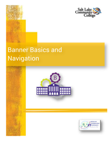
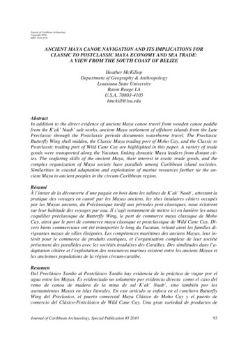
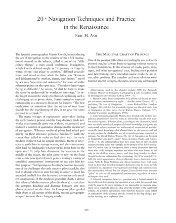
Navigation Techniques and Practice in the Renaissancefig. 20.1. A TYPICAL PAGE FROM THE RUTTER THESAFEGARDE OF SAYLERS, 1590. Although this was a published work, most rutters circulated in manuscript form. Thiswork contained little more than a collection of compass headings, estimated distances, and rough sketches of coastal features and landmarks by which the pilot was supposed to guidehis ship.Size of the original page: ca. 19 12.1 cm. CornelisAnthonisz., The Safegarde of Saylers, or Great Rutter . . . ,trans. Robert Norman (London: Edward Allde, 1590). Photograph courtesy of the BL.supervision of a more experienced mentor, before he couldbe entrusted with the safety of ship, crew, and cargo onhis own.10 Some literate pilots took the step of recordingand compiling their store of knowledge in written form,for use both as an instructional aid for apprentices and asa helpful reminder for themselves when sailing less familiar routes. Such a written document was known in Italian as a portolano, and in French as a routier; the Englishcorrupted the latter into the word “rutter” (fig. 20.1).11Collections of such navigational data may well have beenin use from ancient times, but they became popular in theMediterranean during the late medieval period. Suchworks proliferated, circulating mainly among Mediterranean pilots first in manuscript and later in printed form,from the fourteenth century onward.12The earliest surviving rutter, known as “Lo compassoda navigare,” was written in the Italian vernacular anddated 1296, though it probably represents a revision ofan even earlier original, now lost. This small manuscriptlists the distances and bearings between ports throughoutthe Mediterranean and Black seas, as well as data regarding water depth, anchorages, and landmarks for recognizing the approaches to various harbors.13 Though themajority of the work is dedicated to routes that hug511the coastline, it also contains information describing overtwo hundred long-distance, pelagic routes that wouldhave taken pilots well out of si
sources; Richard Eden, for example, in the preface to his 1561 transla-tion of Cortés’s Arte of Nauigation,drew a sharp distinction between those who could navigate anywhere and those who were bound to sail only in the shallow waters, rivers, and bays long familiar to them, though he did not differentiate his terminology (fol. [C.iv verso]–CC.i). Still, the strict separation is often .