Transcription
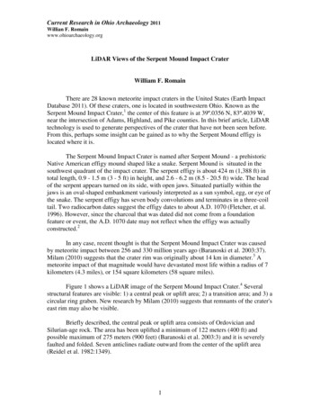
Current Research in Ohio Archaeology 2011Willian F. Romainwww.ohioarchaeology.orgLiDAR Views of the Serpent Mound Impact CraterWilliam F. RomainThere are 28 known meteorite impact craters in the United States (Earth ImpactDatabase 2011). Of these craters, one is located in southwestern Ohio. Known as theSerpent Mound Impact Crater,1 the center of this feature is at 39º.0356 N, 83º.4039 W,near the intersection of Adams, Highland, and Pike counties. In this brief article, LiDARtechnology is used to generate perspectives of the crater that have not been seen before.From this, perhaps some insight can be gained as to why the Serpent Mound effigy islocated where it is.The Serpent Mound Impact Crater is named after Serpent Mound - a prehistoricNative American effigy mound shaped like a snake. Serpent Mound is situated in thesouthwest quadrant of the impact crater. The serpent effigy is about 424 m (1,388 ft) intotal length, 0.9 - 1.5 m (3 - 5 ft) in height, and 2.6 - 6.2 m (8.5 - 20.5 ft) wide. The headof the serpent appears turned on its side, with open jaws. Situated partially within thejaws is an oval-shaped embankment variously interpreted as a sun symbol, egg, or eye ofthe snake. The serpent effigy has seven body convolutions and terminates in a three-coiltail. Two radiocarbon dates suggest the effigy dates to about A.D. 1070 (Fletcher, et al.1996). However, since the charcoal that was dated did not come from a foundationfeature or event, the A.D. 1070 date may not reflect when the effigy was actuallyconstructed.2In any case, recent thought is that the Serpent Mound Impact Crater was causedby meteorite impact between 256 and 330 million years ago (Baranoski et al. 2003:37).Milam (2010) suggests that the crater rim was originally about 14 km in diameter.3 Ameteorite impact of that magnitude would have devastated most life within a radius of 7kilometers (4.3 miles), or 154 square kilometers (58 square miles).Figure 1 shows a LiDAR image of the Serpent Mound Impact Crater.4 Severalstructural features are visible: 1) a central peak or uplift area; 2) a transition area; and 3) acircular ring graben. New research by Milam (2010) suggests that remnants of the crater'seast rim may also be visible.Briefly described, the central peak or uplift area consists of Ordovician andSilurian-age rock. The area has been uplifted a minimum of 122 meters (400 ft) andpossible maximum of 275 meters (900 feet) (Baranoski et al. 2003:3) and it is severelyfaulted and folded. Seven anticlines radiate outward from the center of the uplift area(Reidel et al. 1982:1349).1
Current Research in Ohio Archaeology 2011Willian F. Romainwww.ohioarchaeology.orgThe transition zone is the area between the radial features of the central uplift areaand the concentric faults of the outer ring graben. Topographically the region is lowerrelative to the two zones that surround it. The area is mostly Silurian rock.Figure 1. LiDAR view of the Serpent Mound Impact Crater. LiDAR image andmodel by William F. Romain. Data download from Ohio Statewide ImageryProgram by William F. Romain and Jeffrey Wilson, accessed 12-2011. Verticalexaggeration 2.0. Crater dimensions based on Milam (2010), Hansen (1994), Reidel,et al. (1982).The circular ring graben consists of Silurian to Mississippian-age rock (Reidel, etal. 1982). It is characterized by concentric faults. The center of the ring graben appearstopographically elevated due to the erosional resistance of the Mississippian-age rock ascompared to the less-resistant surrounding rock (see Hansen 1994:4 for an illustration ofthe phenomenon).It is well-known that craters of this size exhibit not only a central uplift area anddepressed floor, or ring graben, but also an outer rim. Prior to Milam's (2010) work,however, the rim of the Serpent Mound Impact Crater had not been definitivelyidentified. Milam (2010:34) suggests that earlier identification of the crater's rim washampered by the severely eroded nature of the rim on its west and southwest sides andglacial activity and deposition on the rim's northwest side.2
Current Research in Ohio Archaeology 2011Willian F. Romainwww.ohioarchaeology.orgIn search of the crater rim, Milam utilized three approaches. First he mademorphometric estimates for the size of the crater rim based on known ratios of centralpeak-to-rim distances. Next, he analyzed subsurface data from hundreds of logs for gas,water, and oil wells across the crater area. Using these data, he constructed a subsurfacecontour map showing the lateral extent of the structural deformation of the Devonian-agerocks across the area. Lastly, he examined dozens of topographic DEM profiles for tracesof the crater. What he found was that a series of hills to the east match the modeledlocation for the crater rim. These hills conform to an arc that appears to represent thecrater's rim. Considered together, these three lines of evidence led to one conclusion:The consistency of modeled crater diameter ranges usingmultiple techniques, the circularity of the eastern ridge and itsconformity to the interior portions of the crater and the lateralextent and circularity of structural deformation all suggest thatthe maximum diameter of the Serpent Mound impact crateris approximately 14 km and that the circular ridge east of thedisturbed area.represents the eroded remnant of the craterrim (Milam 2010:42-43).Figure 2 shows a LiDAR profile through the impact crater. Visible in this figureare the central peak, ring graben, and posited crater rim.Figure 2. LiDAR profile across the Serpent Mound Impact Crater. Image andanalysis by the author.3
Current Research in Ohio Archaeology 2011Willian F. Romainwww.ohioarchaeology.orgDiscussionMilam's work is a significant contribution to our understanding of the morphologyof the Serpent Mound Impact Crater. Specifically, it demarcates the extent of a rarelandscape feature. Although it is not known if early Native Americans - including theSerpent Mound builders, surmised that a meteorite impacted the area, it seems likely that,at minimum, the nature of the landscape within the impact zone would have beenrecognized as unusual. The uplifted, vertically-tilted, and down-dropped rock formationsrepresenting deviations exceeding 100 meters within the crater are impressive. Indeed thepeculiar nature of the area led John Locke in 1838 to observe:.it became evident that a region of no small extent had sunkendown several hundred feet, producing faults, dislocations andupturning of the layers of the rocks.On traveling from LocustGrove to Sinking Spring, I found that a tract large enough for atownship, reaching within a mile of Sinking Spring and extendingseveral miles up Straight Creek, was in the same manner dislocatedand sunken about four hundred feet.it is evident that this mountainat some remote period of time, has sunk down from its original place,and I venture to call it the 'Sunken Mountain' (Locke 1838:266-267).If the jumbled landscape of the Serpent Mound Impact Crater was evident to John Lockein the 1800s, then, I would propose, it may also have been noticed by the builders ofSerpent Mound - whomever they were. Given that, we can speculate that perhaps theunusual nature of the area contributed to selection of the present location for SerpentMound. As such, the serpent effigy is appropriately situated in an area of highly disturbedrock formations on a grand scale - suitable evidence to mark the occasion, perhaps, whenthe Great Horned Serpent of Native American legend, rose from the depths of theLowerworld and for a time, moved across the landscape - in this world.AcknowledgementsThanks are extended to Dr. Richard Shiels, Director of the Newark EarthworksCenter, The Ohio State University for continued support of my LiDAR work.Gratefulappreciation is also extended to Jeffrey Wilson, who introduced me to LiDAR andgenerously provided core LAS data used to create the Serpent Mound Impact Cratermodel.References CitedBaranoski, M. T., G. A. Schumacher, D. R. Watts, R. W. Carlton, and B. M. El-Saiti2003 Subsurface Geology of the Serpent Mound Disturbance, Adams, Highland, andPike Counties, Ohio. Ohio Department of Natural Resources, Division ofGeological Survey, Report of Investigations No. 146.4
Current Research in Ohio Archaeology 2011Willian F. Romainwww.ohioarchaeology.orgBucher, Walter H.1936 Cryptovolcanic Structures in the United States. International GeologicalCongress, 16th Report. 2:1060-1064.Carlton, R. W., C. Koeberl, M. T. Baranoski, and G. A. Schumacher1998 Discovery of Microscopic Evidence for Shock Metamorphism at the SerpentMound Disturbance, South-Central Ohio: Confirmation of an Origin by Impact.Earth and Planetary Science Letters 162:177-185.Cohen, A. J., T. E. Bunch, and A. M. Reid1961 Central Uplifts of Terrestrial and Lunar Craters. Part 1. Kentland and SerpentMound Disturbances. Journal of Geophysical Research 67:1632-1633.Dietz, Robert S.1960 Meteorite Impact Suggested by Shatter Cones in Rock. Science 131 (3416):17811784.Earth Impact Database.2011 Earth Impact Database. University of New /serpentmound.html.Accessed December 27, 2011.Fletcher, Robert V., Terry L. Cameron, Bradley T. Lepper, Dee Anne Wymer, andWilliam Pickard1996 Serpent Mound: A Fort Ancient Icon? Midcontinental Journal of Archaeology21(1):105-43.Hansen, Michael C.1994 Return to Sunken Mountain: The Serpent Mound Cryptoexplosion Structure. OhioGeology, Winter 1994:1, 3-7.Locke, John1838 Geological Report on Southwest District. Ohio Division of Geological Survey,Second Annual Report 2:201-286.Milam, Keith A.2010 A Revised Diameter for the Serpent Mound Impact Crater in Southern Ohio. OhioJournal of Science 111(3):34-43.Reidel, Stephen P.1975 Bedrock Geology of the Serpent Mound Cryptoexplosion Structure, Adams,Highland, and Pike Counties. Ohio Department of Natural Resources, Division ofGeological Survey, Report of Investigations No. 95.5
Current Research in Ohio Archaeology 2011Willian F. Romainwww.ohioarchaeology.orgReidel, Stephen P., Frank L. Koucky, and J. Roger Stryker1982 The Serpent Mound Disturbance, Southwestern Ohio. American Journal ofScience 282:1343-1377.Romain, William F.2011 The Serpent Mound Project: 2011 Preliminary Results. Paper presented at theOhio Archaeological Council Fall Membership Meeting, October 22, 2011.Romain, William F. and Jarrod Burks2008a LiDAR Imaging of the Great Hopewell Road. Current Research in OhioArchaeology 2008, tion com content&task view&id 231&Itemid 32, accessed December 27,2011.2008b LiDAR Assessment of the Newark Earthworks. Current Research in OhioArchaeology 2008, tion com content&task view&id 232&Itemid 32, accessed December 27,2011.2008c LiDAR Analyses of Prehistoric Earthworks in Ross County, Ohio. CurrentResearch in Ohio Archaeology hp?option com content&task view&id 232&Item 32, accessedDecember 27, 2011.1Several theories have been proposed for the origin of the Serpent Mound disturbance feature. This hasresulted in different names for the feature to include: Serpent Mound Cryptovolcanic Structure (Bucher1936), Serpent Mound Disturbance (Reidel et al. 1982), Serpent Mound Cryptoexplosion Structure (Reidel1975, Hansen 1994), and Serpent Mound Impact Crater (Milam 2010). Today, the preponderance ofevidence (e.g., bedrock geology, planar deformed quartz, shatter cones, presence of iridium) suggests thatthe feature is the result of meteorite impact (Dietz 1960, Cohen et al. 1961, Carlton et al. 1998, Baranoskiet al. 2003).2The question of when the Serpent Mound was built is one of the questions currently being investigated byThe Serpent Mound Project. Comprised of experts from a variety of fields, The Serpent Mound Project hasbeen conducting Geoprobe coring, hand coring, magnetic gradiometer, electric resistivity, and other nonand minimally invasive techniques at Serpent Mound to learn more about the effigy (Romain 2011).3Diameters for the central uplift, ring graben, and outer rim vary - depending on what methods are used toassess those variables (see e.g., Milam 2010:Table 1). For example, if the presence of shatter cones is usedto estimate the extent of the central uplift, then the diameter of that feature is about 2.6 km. If, however,slope profiles are used, then the diameter ranges from 4.6 to 5 km (Milam 2010:35). Complicating thematter is that the impact crater does not describe a perfect circle; rather, it is slightly elongated along itsnorth-south axis.In Figure 1, the drawn radius for the crater rim is a best fit approximation to prominent features visible inthe LiDAR imagery and that are proposed by Milam (2010) as surviving traces of the crater's rim. As a6
Current Research in Ohio Archaeology 2011Willian F. Romainwww.ohioarchaeology.orgresult, the dimension for the crater rim provided in Figure 1 differs from the maximum value of 14 kmprovided by Milam (2010:43). Again, however, the dimension provided in Figure 1 is not intended as amaximum dimension. Moreover, the Figure 1 dimension falls within Milam's maximum and minimumdiameter estimates for the rim.4LiDAR is an acronym for Light Detection and Ranging. LiDAR directs a beam of near-infrared laser lightto a target. The reflected light is then used to determine the distance to the target. In the case of aerialLiDAR, this distance information is combined with GPS (Global Positioning System) data. The result is aprecise set of three-dimensional coordinates for a targeted point on the ground. Typically, thousands, oreven millions of coordinate data points are next integrated by computer, with the result being a threedimensional model of the ground terrain. For further discussion of what LiDAR is and how it works, seeRomain and Burks 2008a, 2008b, 2008c.Several small glitches appear in the Figure 1 LiDAR image. In these areas, the terrain appears flattened.This unfortunate result sometimes occurs when very large models are created. It appears that in these areas,the computer program is not able to link successfully the underlying LAS files.7
LiDAR Views of the Serpent Mound Impact Crater William F. Romain There are 28 known meteorite impact craters in the United States (Earth Impact Database 2011). Of these craters, one is located in southwestern Ohio. Known as the Serpent Mound Impact Crater,1 the center of this feature is at 39º.0356 N, 83º.4039 W,