Transcription
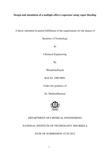
Renuka was excited. Shrikant Uncle was home after agap of nearly four months. He was a wildlife photographerand travelled widely. Renuka’s interest in wildlife andforests began at an early age, when her uncle introducedher to books on nature. Pictures of distant lands andpeople, who lived there, always fascinated her.Fig. 8.1: People from various parts of the world“In these pictures Renuka, you can see people fromdifferent parts of the world – some from dry deserts, somefrom frozen lands and some from hot wet rainforests.”“They look so different from me”, observed Renuka. “Theymay look different, but they share the same basic needsof life – food, clothing and shelter”, explained Shrikant Uncle.“Their children do the same things as you probably do,play games, quarrel sometimes and then make-up, sing,dance and help the families with various things that needto be done. They live closer to nature and very early intheir lives have learnt to care for nature. They learn howto catch fish and how to collect material from the forests.”2021-22
In Chapters 8, 9 and 10, you will learn about the lifeof people in the different natural regions of the world.Do you know?When Spanishexplorers discoveredthe Amazon river,they were attacked bya group of local tribeswearing headgearsand grass skirts.These peoplereminded them of thefierce tribes of womenwarriors known inancient RomanEmpire as theAmazons. Hence thename Amazon.LIFEIN THEAMAZON BASINBefore learning about the Amazon basin, let us look at themap (Fig. 8.2). Notice that the tropical region lies veryclose to the equator; between 10 N and 10 S. So, it is referredto as the equatorial region. The river Amazon flows throughthis region. Notice how it flows from the mountains to thewest and reaches the Atlantic Ocean to the east.The place where a river flows into another body ofwater is called the river’s mouth. Numerous tributariesjoin the Amazon River to form the Amazon basin. Theriver basin drains portions of Brazil, parts of Peru, Bolivia,Ecuador, Columbia and a small part of Venezuela.Name the countries of the basin through which theequator passes.GlossaryTributaries: Theseare small rivers thatjoin the main river.The main river alongwith all its tributariesthat drain an areaforms a river basin orthe catchment area.The Amazon Basin isthe largest river basinin the world.Fig. 8.2: The Amazon Basin in South America56OUR ENVIRONMENT2021-22
CLIMATEAs you now know, the Amazon Basin stretches directlyon the equator and is characterized by hot and wet climatethroughout the year. Both day and nights are almostequally hot and humid. The skin feels sticky. It rainsalmost everyday, that too without much warning. Theday temperatures are high with very high humidity. Atnight the temperature goes down but the humidityremains high.RAINFORESTSAs it rains heavily in this region, thick forestsgrow (Fig. 8.3). The forests are in fact so thickthat the dense “roof” created by leaves andbranches does not allow the sunlight to reachthe ground. The ground remains dark and damp.Only shade tolerant vegetation may grow here.Orchids, bromeliads grow as plant parasites.Fig. 8.3 : The Amazon ForestThe rainforest is rich infauna. Birds such as toucans (Fig. 8.4),humming birds, macaw with theirbrilliantly coloured plumage, oversizedDo you know?bills for eating make them differentfrom birds we commonly see in India.Bromeliads areThese birds also make loud sounds inspecial plants thatstore water in theirthe forests. Animals like monkeys,Fig. 8.4 : Toucans sloth and ant-eating tapirs are foundleaves. Animals likefrogs use thesehere (Fig. 8.5). Various species of reptiles and snakespockets of water foralso thrive in these jungles. Crocodiles, snakes, pythonslaying their eggs.abound. Anaconda and boa constrictor are some of thespecies. Besides, the basin is home to thousands ofspecies of insects. Severalspecies of fishes including theflesh-eating Piranha fish isLet’s doalso found in the river. Thisbasin is thus extraordinarilySome TV channelsrich in the variety of life foundbroadcastthere.Fig. 8.5 : Tapirdocumentaries on thePEOPLE OFTHERAINFORESTSPeople grow most of their food in small areas after clearingsome trees in the forest. While men hunt and fish alongthe rivers, women take care of the crops. They mainly growHUMAN ENVIRONMENT INTERACTIONS: THE TROPICAL2021-22wildlife of the world.Try to watch some ofthe films and shareyour experience withthe class.AND THESUBTROPICAL REGION57
Do you know?Slash and Burn is away of cultivating landwhere farmers clear apiece of land byslashing or cuttingdown trees and bushes.These are then burnt,which releases thenutrients into the soil.Now crops are grown inthis cleared field for afew years.After repeatedlyusing the patch ofland, the soil loosesits nutrients. So it isabandoned. Then theyclear another plot ofland to plant. In themean time youngtrees grow in the oldfield. In this way soilfertility is restored.People can thenreturn to it and startcultivating it again.tapioca, pineapple and sweet potato. As hunting and fishingare uncertain it is the women who keep their families aliveby feeding them the vegetables they grow. They practice“slash and burn agriculture”. The staple food is manioc,also known as cassava that grows under the ground likethe potato. They also eat queen ants and egg sacs. Cashcrops like coffee, maize and cocoa are also grown.The rainforests provide a lot of wood for the houses.Some families live in thatched houses shaped likebeehives. There are other large apartment-like housescalled “Maloca” with a steeply slanting roof.Life of the people of the Amazon basin is slowlychanging. In the older days the heart of the forest, couldbe reached only by navigating the river. In 1970 the TransAmazon highway made all parts of the rainforestaccessible. Aircrafts and helicopters are also used forreaching various places. The indigenous population waspushed out from the area and forced to settle in newareas where they continued to practice their distinctiveway of farming.The developmental activities are leading to the gradualdestruction of the biologically diverse rainforests. It isestimated that a large area of therainforest has been disappearingannually in the Amazon basin.You can see that thisdestruction of forests hasa much wider implication(Fig. 8.6). The topsoil iswashed away as therains fall and thelush forestturns intoa barrenlandscape.Fig. 8.6: Gradual Destruction of Forests58OUR ENVIRONMENT2021-22
LIFEIN THEGANGA-BRAHMAPUTRA BASINThe tributaries of rivers Ganga andBrahmaputra together form theGanga-Brahmaputra basin in theIndian subcontinent (Fig. 8.8). Thebasin lies in the sub-tropical regionthat is situated between 10 N to 30 Nlatitudes. The tributaries of the RiverGanga like the Ghaghra, the Son, theChambal, the Gandak, the Kosi andthe tributaries of Brahmaputra drainit. Look at the atlas and find namesof some tributaries of the RiverBrahmaputra.Fig. 8.7 Brahmaputra riverThe plains of the Ganga and theBrahmaputra, the mountains and the foothills of theFig. 8.8: Ganga-Brahmputra BasinHUMAN ENVIRONMENT INTERACTIONS: THE TROPICAL2021-22AND THESUBTROPICAL REGION59
Let’s doRiver Brahmaputra isknown by differentnames in differenceplaces. Find the othernames of the river.GlossaryPopulation density:It means the numberof persons that live inone sq. km. of areae.g. the populationdensity of Uttarakhandis 189 while thedensity of WestBengal is 1029 andthat of Bihar is 1102.ActivityCollect somehandicrafts madefrom jute, bamboo andsilk. Display them inthe class. Find out inwhich area they weremade?Himalayas and the Sundarbans delta are the mainfeatures of this basin. Ox-bow lakes dot the plain area.The area is dominated by monsoon climate. Themonsoon brings rains from mid-June to mid-September.The summers are hot and the winters cool.Look at the map of India (Fig. 8.8). Find out the statesin which the Ganga-Brahmputra basin lies.The basin area has varied topography. Theenvironment plays a dominant role in the distributionof the population. The mountain areas with steep slopeshave inhospitable terrain. Therefore less number ofpeople live in the mountain area of the GangaBrahmaputra basin. The plain area provides the mostsuitable land for human habitation. The soil is fertile.Agriculture is the main occupation of the people whereflat land is available to grow crops. The density ofpopulation of the plains is very high. The main crop ispaddy (Fig. 8.9). Since cultivation of paddy requiressufficient water, it is grown in the areas where the amountof rainfall is high.Wheat, maize, sorghum, gram and millets are theother crops that are grown. Cash crops like sugarcaneand jute are also grown. Banana plantations are seen insome areas of the plain. In West Bengal and Assam tea isgrown in plantations (Fig. 8.10). Silk is produced throughthe cultivation of silk worms in parts of Bihar and Assam.In the mountains and hills, where the slopes are gentle,crops are grown on terraces.The vegetation cover of the area varies according tothe type of landforms. In the Ganga and Brahmaputraplain tropical deciduous trees grow, along with teak, saland peepal. Thick bamboo groves are common in theBrahmaputra plain. The delta area is covered with theFig. 8.9 : Paddy Cultivation60Fig. 8.10 : Tea Garden in AssamOUR ENVIRONMENT2021-22
mangrove forests. In parts of Uttarakhand, Sikkim andArunachal Pradesh, coniferous trees like pine, deodarand fir can be seen because the climate is cool and theslopes are steep.There is a variety of wildlife in the basin. Elephants,tigers, deer and monkeys are common. The one-hornedrhinoceros is found in the Brahmaputra plain. In thedelta area, Bengal tiger and crocodiles are found. Aquaticlife abounds in the fresh river waters, the lakes and theBay of Bengal Sea. The most popular varieties of the fishare the rohu, catla and hilsa. Fish and rice is the staplediet of the people living in the area.Do you know?Terraces are built onsteep slopes to createflat surfaces on whichcrops are grown. Theslope is removed sothat water does notrun off rapidly.Terrace FarmingFig. 8.11 : One horned rhinocerosFig. 8.12 : CrocodilesLake: A source of livelihood(A case study)Binod is a fishermanliving in the MatwaliMaun village of Bihar.He is a happy mantoday. With the effortsofthefellowfishermen – Ravindar,Kishore, Rajiv andothers, he cleaned themaun or the ox-bowA clean lakelake to cultivatedifferent varieties of fish. The local weed (vallineria,hydrilla) that grows in the lake is the food of the fish.The land around the lake is fertile. He sows cropssuch as paddy, maize and pulses in these fields.The buffalo is used to plough the land. Thecommunity is satisfied. There is enough fish catchfrom the river – enough fish to eat and enough fishHUMAN ENVIRONMENT INTERACTIONS: THE TROPICAL2021-22Do you know?In the fresh waters ofRiver Ganga and RiverBrahmaputra, avariety of dolphinlocally called Susu(also called blinddolphin) is found. Thepresence of Susu is anindication of thehealth of the river. Theuntreated industrialand urban wastes withhigh amount ofchemicals are killingthis species.Blind DolphinAND THESUBTROPICAL REGION61
Do you know?To acceletrate theefforts to achieveuniversal sanitationcoverage and to putfours on sanitation,the Prime Minister ofIndia launched the“Swachh BharatMission” on 02ndOctober 2014.to sell in the market. They have even begun supplyto the neighbouringtown. The communityis living in harmonywith nature. As longas the pollutants fromnearby towns do notfind their way into thelake waters, the fishcultivation will notA Polluted Lakeface any threat.The Ganga-Brahmaputraplain has several big townsand cities. The cities ofAllahabad, Kanpur, Varanasi,Lucknow, Patna and Kolkataall with the population ofmore than ten lakhs arelocated along the RiverGanga (Fig. 8.13). TheFig. 8.13: Varanasi along the River Gangawastewater from these townsand industries is discharged into the rivers. This leadsto the pollution of the rivers.Do you know?All the four ways of transport are well developed inthe Ganga-Brahmaputra basin. In the plain areas theTo conserve the riverroadways and railways transport the people from oneganga, ‘Namami’ganga Programme hasplace to another. The waterways, is an effective means ofbeen initiated.transport particularly along the rivers. Kolkata is animportant port on the River Hooghly. The plain area alsohas a large number of airports.Tourism is another important activityof the basin. Taj Mahal on the banks ofRiver Yamuna in Agra, Allahabad on theconfluence of the Rivers Ganga andYamuna, Buddhists stupas in UttarPradesh and Bihar, Lucknow with itsImambara, Assam with Kaziranga andManas with wild life sanctuaries andArunachal Pradesh with a distincttribal culture are some of the placesworth a visit (Fig. 8.14).Fig. 8.14: Tiger in Manas Wildlife sanctuary62OUR ENVIRONMENT2021-22
Exercises1. Answer the following questions.(i) Name the continent in which the Amazon Basin is located.(ii) What are the crops grown by the people of the Amazon Basin.(iii) Name the birds that you are likely to find in the rainforests of the Amazon.(iv) What are the major cities located on the River Ganga.(v) Where is the one-horned rhinoceros found?2. Tick the correct answer.(i) Toucans are a type of(a) birds(b) animals(ii) Manioc is the staple food of(a) Ganga Basin(b) Africa(c) crops(c) Amazon(iii) Kolkata is located on the river(a) Orange(b) Hooghly(c) Bhagirathi(iv) Deodars and firs are a type of(a) Coniferous trees (b) Deciduous trees (c) shrubs(v) Bengal tiger is found in(a) mountains(b) delta area(c) Amazon3. Match the following.(i) Cotton textile(ii) Maloca(a) Assam(b) Terrace farming(iii) Piranha(iv) Silk worm(c) Sericulture(d) Slanting roof(v) Kaziranga(e) Ganga plain(f) Varanasi(g) Fish4. Give reasons.(i) The rainforests are depleting.(ii) Paddy is grown in the Ganga-Brahmaputra plains.5. Map skills.(i) On an outline map of the Indian Sub-continent, draw the rivers Ganga andBrahmaputra from the source to the mouth. Also show the importanttributaries of both the rivers.(ii) On the political map of South America, draw the equator. Mark the countriesthrough which the equator passes.6. For fun.Make a collage to show places of attractions in India. You can divide the classin different groups to show attractions based on mountain landscapes, coastalbeaches, wildlife sanctuaries and places of historical importance.HUMAN ENVIRONMENT INTERACTIONS: THE TROPICAL2021-22AND THESUBTROPICAL REGION63
7. Activity.Collect under mentioned material and observe how destruction of trees effectthe soil cover.Material(i) Three small flowerpots or food cans (e.g., cold drinks tin cans),(ii) one big can with holes punched in the bottom (this will act as asprinkling can),(iii) twelve coins or bottle caps(iv) soil.StepsTake three small cans or pots. Fill them with soil till the top. Press the soil tomake it level with the top of the can. Now put four coins or bottle caps on thesoil of each can. Take the big can that has been punched with holes and fill itwith water. You can also take the sprinkling can from your garden. Now, sprinklewater on the three cans. On the first can sprinkle water very slowly so that nosoil splashes out. Let moderate amount of water be sprinkled on the secondcan. On the third can, sprinkle the water heavily. You will observe thatunprotected soil splashes out. Where the ‘rain’ is heavy the amount of soil thatsplashes out is the maximum and least in case of the first can. The coins orcaps represent the tree covers. It is clear that if the land is cleared completelyof the vegetation, the soil cover will quickly disappear.64OUR ENVIRONMENT2021-22
Before learning about the Amazon basin, let us look at the map (Fig. 8.2). Notice that the tropical region lies very close to the equator; between 10 N and 10 S. So, it is referred to as the equatorial region. The river Amazon flows through this region. Notice how it flows from the mountain