Transcription
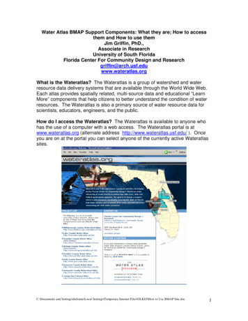
Water Atlas BMAP Support Components: What they are; How to accessthem and How to use themJim Griffin, PhD.,Associate in ResearchUniversity of South FloridaFlorida Center For Community Design and Researchgriffin@arch.usf.eduwww.wateratlas.orgWhat is the Wateratlas? The Wateratlas is a group of watershed and waterresource data delivery systems that are available through the World Wide Web.Each atlas provides spatially related, multi-source data and educational “LearnMore” components that help citizens to better understand the condition of waterresources. The Wateratlas is also a primary source of water resource data forscientists, educators, engineers, and the public.How do I access the Wateratlas? The Wateratlas is available to anyone whohas the use of a computer with a web access. The Wateratlas portal is atwww.wateratlas.org (alternate address http://www.wateratlas.usf.edu/ ). Onceyou are on at the portal you can select anyone of the currently active Wateratlassites.C:\Documents and Settings\dufraine\Local Settings\Temporary Internet Files\OLK65\How to Use BMAP Site.doc1
How is the Wateratlas supporting the current NE Tampa Bay WatershedBMAP Process? The Wateratlas provides a single web address for all approvedNE Tampa Bay BMAP working group documents for use by anyone interested inthe BMAP process and activities and a customized mapping component for theworking group and stakeholders’ use.How do I access the documents area? All BMAP documents are providedthrough the Tampa Bay Wateratlas on the “News and Views” page in theCommittees and Projects section under NE Tampa Bay Watershed BMAPWorking Group.You access the Wateratlas, go to the Tampa Bay Estuary Atlas, then selectNews & Events, Northeast Tampa Bay Wateratlas BMAP Working Group andthen view or download desired documents as pdf files.C:\Documents and Settings\dufraine\Local Settings\Temporary Internet Files\OLK65\How to Use BMAP Site.doc2
What is the BMAP Mapping Component? The BMAP mapping component is aArcIMS Geographic Information Mapping and Information System that iscustomized for Wateratlas use and has been further customized for the BMAPworking group. The component offers a full range of mapping capabilities overthe World Wide Web to your desk top. The Florida Center is working with FDEPto provide the latest BMAP related spatial data. FDEP prepares GIS files andsends them to the working group and the Florida Center. FCCDR then reviews,and reformats the files for display in ArcIMS and serves them via theHillsborough County Watershed Atlas site.How do I access the BMAP Mapping Component? Go to the Wateratlas site(www.wateratlas.usf.edu ) and make the following change in the address: (1)replace www with “maps” and (2) add BMAP at the end of the string. The newaddress is: http://maps.wateratlas.usf.edu/BMAP/ . You can also just type thisaddress into your address line and select it.The mapping component has all of the FDEP provided spatial data layers loadedand available for use (right hand panel) and some general (BMAP, Water,Environmental, Planning and Infrastructure and scale dependent AerialPhotographs) layers to make the use of the spatial data layers more efficient andeffective. The component also has the standard Wateratlas tool set fornavigation and data mining and management (left hand panel).C:\Documents and Settings\dufraine\Local Settings\Temporary Internet Files\OLK65\How to Use BMAP Site.doc3
How do I open and use layers? To open a layer simple select the layercategory arrow to down and then select the layer(s) that you want to display andselect refresh. To get help at for use of component select “? Map Help”. Note:To see map help or any of our pre-formatted pop-up views you must de-activateyour pop-up blocker.C:\Documents and Settings\dufraine\Local Settings\Temporary Internet Files\OLK65\How to Use BMAP Site.doc4
You can select and activate any layer and as many layers that you need. Whenyou zoom to a map scale less than 1:24,000, the Aerials are available forbackground.Above is a map view with 2004 aerial layer. The gray numbers with whitebackground are the Water Body ID or WBID and the blue numbers are theHydrologic Unit Code or HUC. Notice the scale on the bottom is 1:24,000. Thisis the map scale at which the Aerials are available. You must select the aerialand refresh the map to make the aerials active layers.How do I access the data that is contained in one or more active maplayers? You will use the info icon (i) on the map to generate a pop-up with all“attribute” data for the dataset that generates the map layer. A GIS layer issimply a data table with a spatial characteristic. Attributes to a spatialcharacteristic are its data. Select the “I” icon and a table will appear as a pop-up.(Remember that your pop-up blocker must be off). You probably need to resizethe table to read all data selected. Please see graphic on next page.C:\Documents and Settings\dufraine\Local Settings\Temporary Internet Files\OLK65\How to Use BMAP Site.doc5
The above display shows the nitrogen exceedance and trend data for threestations in Tampa Bay within WBID 1558E and HUC 03100206.How do I download the actual files that I see on the Mapping Component?If FDEP and/or the BMAP working group request, the actual datafiles are madeavailable through the “Download Data” function (left side panel). You simplyC:\Documents and Settings\dufraine\Local Settings\Temporary Internet Files\OLK65\How to Use BMAP Site.doc6
select download and then right click the file you want to download and select“Save as” and save to your computer memory in a file of your choice.C:\Documents and Settings\dufraine\Local Settings\Temporary Internet Files\OLK65\How to Use BMAP Site.doc7
More" components that help citizens to better understand the condition of water resources. The Wateratlas is also a primary source of water resource data for scientists, educators, engineers, and the public. How do I access the Wateratlas? The Wateratlas is available to anyone who has the use of a computer with a web access.