Transcription
AWARE Toolkit User Guide
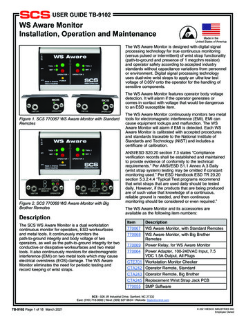
CHAPTER 1AWARE Toolkit User GuideIntroductionThis toolkit is intended to help airports of all sizes do the following:1. Understand the significant weather events1 that could affect their locations2. Assess their readiness for different types of significant weather events (especially infrequent events with which airport staff may be less familiar)3. Identify best practices and action items to increase readiness for such events4. Track the costs and effects of weather events over timeThe AWARE Toolkit was developed for ACRP Project 02-49. The final toolkit,in accordance with airport feedback, is structured around three primary steps,each associated with its own tool, or “module” in the toolkit (see Figure 1-1).Note: If you are using anelectronic version of this UserGuide, you may choose tonavigate the document throughthe hyperlinked text.The Exposure Information Module provides information on how frequently differentweather events occur in an airport’s location and which of those are “rare but plausible” (theACRP Project 02-49 Contractor’s Final Report, available on the project webpage, provides moredetailed information). The Readiness Modules, for a given subject, enable users to review bestpractices for preparing for different weather events, assess readiness for those events, and generate customized checklists. The AWARE Toolkit contains seven readiness modules. Six of thereadiness modules are designed for use by larger airports: Administration & Finance (including human resources functions, airport leadership, insur-ance coordination, budgeting, public relations, and tenant and maintenance contracting); Planning & Environment (including capital programs, strategic planning, infrastructuredesign, and coordination with outside organizations and partners); Airfield Operations (including gate, runway management, and tarmac operations, air trafficcontrol coordination); Terminal Operations (including check-in and ticketing, gate areas and terminal space beyondTSA checkpoints, information technology infrastructure, terminal maintenance, and otheroperational areas aside from those that support aircraft). Ground Transportation & Parking (including parking lots, transit stations, taxi stands, curbside facilities, access roads, and road and parking maintenance); Safety & Security (including TSA checkpoints, badging and identification systems, airportwide emergency operations center, fire-fighting operations, and on-airport communicationsystems)1AWARE focuses on extreme weather events that could happen today. It does not project how those events may change infrequency or severity due to climate change. The Exposure Information Module does include information from the ACROStool on whether certain weather events are expected to increase or decrease in frequency due to climate change (see ACRPReport 147: Climate Change Adaptation Planning for more information on ACROS). The ACROS information is included asadditional information for the user, but climate change ultimately does not factor into which events are recommended by theExposure Information Module for further evaluation by AWARE.TK-3
TK-4Addressing Significant Weather Impacts on Airports: Quick Start Guide and ToolkitFigure 1-1. AWARE toolkit diagram.The seventh readiness module, Small Airports, is a consolidated, streamlined version of thefull toolkit intended to be completed by one person. This may be more appropriate for airports with fewer staff, such as General Aviation (GA) airports or FAA small-hub airports. Eachreadiness module enables users to complete a readiness self-assessment, review the results, andgenerate customized checklists with best practices for preparing for extreme weather events (seeSection 3.7 for details).For larger airports, the AWARE Toolkit is designed so that a single “AWARE coordinator”(e.g., a staff member within the planning or emergency preparedness offices) can distribute andcoordinate use of the tool across the various functional areas. The tool will then compile theoutputs from each of the modules into a single product for the airport. This will allow for coordination across the functional areas, but also provide for function-specific best practices. The roleof AWARE coordinator is similar to the “IROPS Champion” described in ACRP Report 65 andis recommended to ensure communication and coordination across airport functional areas.Finally, the Impacts Tracking Module is a tool to help airports track the costs and otherimpacts of weather events (e.g., flight delays) over time, as events occur. The module will helpairports build a database that can be used to inform future weather preparedness investmentdecisions.
CHAPTER 2Toolkit Scope2.1 Weather Event TypesAWARE provides information on potential exposure, readiness self-assessment questions,and best practices for the following 15 extreme weather event types: FloodHeavy rainTropical cyclones (e.g., hurricanes, tropical storms)TornadoesLightningHailHeavy windsExtreme heatExtreme coldSnowBlizzardsIceDense fogDense smokeDust storms2.2 Airport Functional AreasThe toolkit covers six main “functional areas” of airports: Administration & Finance, Planning & Environment, Airfield Operations, Terminal Operations, Ground Transportation &Parking, and Safety & Security. These categories cover the many, more detailed, functions ofairports, as outlined in Table 2-1.TK-5
TK-6Addressing Significant Weather Impacts on Airports: Quick Start Guide and ToolkitTable 2-1. Toolkit modules and the topics covered.ModuleAdministration &FinanceTopics CoveredHuman Resources (HR) functionsAirport leadershipInsurance coordinationTenant contractingBudgeting for capital and operating expensesSocial mediaPublic relations/press relationsReviewing financial impacts of increased weather-related maintenanceContracted services including provisions for existing on-call trades inplace before events and post-event processes for major repair projectsPlanning & Environment Airport Master PlanAirport sustainability and energy managementStrategic planningPlanning documents (e.g., Irregular Operations (IROPS) plan, Continuityof Operations [COOP] Plan)Engineering design standardsEngineering planned improvements (e.g., change in materials, runwaylength/position)Environmental compliance (including noise, groundwater, and hazardousmaterials)NEPA documentationAirfield OperationsRunways (operations and maintenance)Taxiways (operations and maintenance)ApronsJetways/boarding bridgesFlight logisticsAir Traffic ControlFuel tanksDocumenting impacts to airside pavement, runway lighting, and relatedareasDeicingRunway maintenanceOn-airport communication systems (e.g., internal PA system and radios)Terminal OperationsCheck-In/TicketingRetailGate areas, terminal space beyond TSA checkpointsHVAC system upkeep and maintenanceTerminal facility maintenanceJanitorial/custodial servicesWaste removalGatesBaggageLighting and signageUtilities (including electricity, phone lines, and water/wastewater)Information Technology (IT) infrastructureOperational areas aside from those that support aircraft. Pre-security areas.Documenting impacts to terminal buildings (interior and exterior)On-airport communication systems (e.g., internal PA system and radios)Ground Transportation & Parking lotsTransit stationsParkingAccess roadsRecirculation roadCurbside facilitiesOn-airport rental car facilitiesTaxi/limo standsRoad and parking maintenanceDocumenting impacts to airport roads, transit connections, and parkingSafety & SecurityTSA checkpointsTerminal space beyond TSA checkpointsBadging and identification systemsAirport-wide Emergency Operations CenterFire-fighting operationsOn-airport communication systems (e.g., internal PA system and radios)
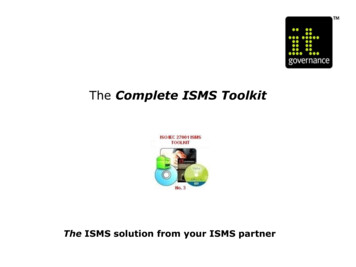
CHAPTER 3Using the Toolkit3.1 System RequirementsAWARE was developed using Microsoft Excel 2010. The tool will only operate properlyusing Excel 2007 versions or later. Before using the tool, make sure your computer meets thesystem requirements. To install and run the tool, you must have the following: An IBM-PC-compatible computer with the Windows XP operating system or laterMicrosoft Excel 2007 or later, with calculation set to automatic and macros enabledA hard drive with at least 20MB freeA monitor display setting of 800 600 pixels or greater.3.2 Setup3.2.1 Preparing the Tool for UseFor the toolkit to function properly, users must extract all files from the .zip file before beginning. To do so, save the toolkit .zip file to your hard drive. Decompress the .zip file by doing oneof the following: Right-click on the .zip folder, select Extract All, and choose a folder to house the zip file’scontents Double-click on the .zip folder to open it, then drag the contents from the compressed folderinto a new locationThen open the file AWARE Toolkit.xlsm.3.2.2 Microsoft Excel SettingsFor the tool to function properly, Excel must be set to automatic calculation. Go to the Formulas ribbon and select Calculation Options. Make sure that the box next to the “Automatic”option is checked from the pop-up menu. NOTE: your default settings may already be set tothese options.3.2.3 Enabling MacrosMacros must be enabled to use each of the toolkit components. If Excel’s security settingsare set at the default level, a security warning appears above the formula box in Excel when thetool is initially opened (Figure 3-1). Click the Enable Content button to begin using the file.TK-7
TK-8Addressing Significant Weather Impacts on Airports: Quick Start Guide and ToolkitFigure 3-1. How to enable macros.If the Security Warning does not appear when the tool is first opened, it may be necessary tochange the security settings for macros. To change the setting Exit out of the tool and re-launch Microsoft Excel before opening the file. Click on the Microsoft Excel icon or File menu in the top left of the screen. Scroll to the bottom of the menu and select the Excel Options button to the right of themain menu. When the Excel Options box appears, select Trust Center in the left-hand menu of the box. Click the gray Trust Center Settings button. When the Trust Center options box appears,click Macro Settings in the left hand menu and select Disable all macros with notification. Once the security level has been adjusted, open the tool and enable macros in the mannerdescribed in the preceding paragraph.(Note: the above description corresponds to Excel 2010. Exact buttons and labeling may bedifferent in other versions of the program, but the same process will apply.)3.3 Toolkit InstructionsAWARE toolkit user tips Pale yellow cells ( Click or hover over the) indicate user entry.icons throughout the toolkit for helpful tips. Clickthe button again to hide the pop-up box. Select the PDF/Print button at the top of certain pages to export contents to aPDF. Remember to save and close the PDF before exporting another PDF.
Using the ToolkitTable 3-1. AWARE toolkit file structure.Folder/FileAWARE ToolkitAWARE Toolkit.xlsmAWARE Toolkit User Guide.pdfAWARE Toolkit Quick Start Guide.pptModulesCompletedAdministration and Finance.xlsmAirfield Operations.xlsmExposure Information Module.xlsmGround Transportation and Parking.xlsmImpacts Tracking Module.xlsmPlanning and Environment.xlsmSafety and Security.xlsmSmall Airports.xlsmTerminal Operations.xlsmItalics folderDescriptionMain toolkit folderStarting point for the toolkit; will help the usernavigate to the other components as needed.User GuideFor users to quickly get familiar with the toolkit.Folder containing toolkit filesFolder for users to save completed modulesReadiness ModuleReadiness ModuleExposure Information ModuleReadiness ModuleImpacts Tracking ModuleReadiness ModuleReadiness ModuleReadiness ModuleReadiness ModuleStep 1. Open the “AWARE Toolkit.xlsm” fileThis file serves as the “hub” of the toolkit and will direct you to the other components as needed. Other components of the toolkit should open automaticallywhen you press the orange buttons in the AWARE Toolkit file. However, if youhave changed the name or organization of the toolkit folder (defaults shown inTable 3-1), the tool will prompt you with a pop-up window asking you whichfile to open. Users may also refer to the Quick Start Guide in the same folder.Step 2. Enter Airport NameEnter your three-letter IATA airport code in the cell provided. If your airport code is not in the drop-down menu, leave the cell blank. Users can alsoenter their airport name in the cell below. This field is optional, and used topopulate title fields in tool-generated reports (e.g., AWARE Toolkit Reportfor My Airport).Step 3. Select Toolkit Version—Small vs. Large AirportOpening other files from theAWARE toolkitOther components of the toolkitshould open automatically whenyou press the orange buttons in theAWARE Toolkit file. However, if youhave changed the name or organization of the toolkit folder (defaultsshown in Table 3-1), the tool willprompt you with a popup windowasking you which file to open.Open ExposureInforma on ModuleUse the radio button to select whether you want to use the “small airports”version of the toolkit. The AWARE Toolkit comes in two versions: (1) a full version that contains six distinct readiness modules (Administration & Finance,Planning & Environment, Airfield Operations, Terminal Operations, Ground Transportation &Parking, and Safety & Security) intended to be completed by different staff with expertise in thatarea, and (2) a consolidated “Small Airports” version intended to be completed by one person.The streamlined Small Airports version may be more appropriate with airports with fewer staff.Based on your selection, jump to the instructions for the full toolkit (Section 3.4) or the smallairports toolkit (Section 3.5).3.4 Full Toolkit UsersStep 4. Select User TypeGiven the broad scope of the toolkit and the importance of coordination in weather preparedness, the toolkit is best used with the help of an “AWARE Coordinator.” The AWARE Coordinator is someone who will coordinate use of the toolkit across the airport functional areas. ThisTK-9
TK-10Addressing Significant Weather Impacts on Airports: Quick Start Guide and ToolkitAWARE coordinator roleLarger airports may wish to identifysomeone to serve as the AWARECoordinator to help oversee andcoordinate use of the toolkit acrossdifferent airport functional areas.person should be familiar with a broad range of airport departments andfunctions. Individuals from airport management, planning, or emergencymanagement could be good candidates.If you are the AWARE Coordinator, jump to the AWARE Coordinatorinstructions (Section 3.4.1). If you are not the AWARE Coordinator, jump tothe “Functional Area Manager” instructions (Section 3.4.2).3.4.1 AWARE CoordinatorWhat is the role? Identify appropriate staff tocomplete the toolkit for eachfunctional area Coordinate and assign deadlinesfor functional area modules Compile results across functionalarea modules Encourage communication,coordination, and collaborationacross airport functional areasWho should do it?The AWARE Coordinator shouldbe familiar with a broad range ofairport departments and functions.Consider candidates from airportmanagement, planning, oremergency management.Step 5. Press the Open Exposure Information Module button to identifyweather event types that could affect your airportThis button will open the tool’s Exposure Information Module, whichprovides information on how likely different weather event types are in yourairport’s county. Jump to Section 3.6 for instructions on completing theExposure Information Module.Step 6. Assign and distribute modules to appropriate peopleDetermine who the appropriate staff people are at your airport to complete each module. They should have knowledge of ongoing airport practicesrelated to weather preparedness within their domain. Multiple people mayneed to complete each module if your airport departments do not align perfectly with the six modules. Review the module definitions (click the information icon) to see what topics fall into which modules.Keep track of the module assignments in the table provided. Press the Sendbutton to send each module to the assigned person. Note: If you do not haveMicrosoft Outlook, the “send” functionality will not work. If that is the case,simply send an email to each staff person using your e-mail software andattach the appropriate module file. The files can be found within the Modulesfolder of the toolkit (see Table 3-1).Step 7. Collect and save completed modules (including the exposure module), and storethe file path (see Figure 3-2)As you receive completed modules from your team, save them into the Completed folderwithin the Modules folder. After you save each file, you must press the Store File Path buttonnext to its corresponding row. This is in order to tell the toolkit where to look for the completed module and what it is called (e.g., someone may have changed the file name to appendFigure 3-2. AWARE Coordinator: how to collect store completed modules.
Using the Toolkitthe date or their initials). The file path will appear to the right as confirmation that the stepis complete.You must also press the Store File Path button for the Exposure Information Module if youwould like to include it in your summary report.Select Yes in the Completed Module Returned? column to keep track of modules as youreceive them.Step 8. Generate summary reportOnce you have received modules, press the Compile Results button to generate a summaryreport in PDF. The summary report will cover all modules that you have marked as completeand will include A summary of exposure results (weather event frequency for the county and adjacentcounties) A summary of readiness ratings for all functional areas and weather event types Compiled checklists across all functional areas and weather event typesYou can generate the summary report as many times as desired. You do not have to wait untilall modules are received.In addition to the summary report, the Compile Results button will also create a filterable database of all the checklist items generated in the completed modules. For each item, the databasecontains the applicable Functional Area, Event Type, Stage (e.g., planning, mitigation, response,and recovery), Type (e.g., communications, procedures, and infrastructure), and other notes.At this point, the toolkit is complete, and you should have a set of actions to helpincrease your readiness for extreme weather events. You may want to set a timein the future (e.g., 6 months or 1 year) to re-complete the toolkit and measureyour progress.In addition, you can use the Impacts Tracking Module (see Step 9) to track the costsand impacts of weather events as they occur over time.Step 9. Track impacts over timeThe AWARE Toolkit also includes a standalone Impacts Tracking Module that airports canuse to track the costs and impacts of weather events as they occur over time. Many airports donot have systems in place to monitor how much staff time, equipment, materials, and otherresources they spend preparing for or responding to weather events, except in the case of themost severe events with disaster declarations or major insurance claims. This tool is intendedto enable airports to track costs from events large and small over time so that airports can makemore informed investment decisions. Jump to Section 3.8 for instructions on using the ImpactsTracking Module.3.4.2 Functional Area ManagerStep 5. Press the Open Exposure Information Module button to identify weather eventtypes that could affect your airportTK-11
TK-12Addressing Significant Weather Impacts on Airports: Quick Start Guide and ToolkitThis button will open the tool’s Exposure Information Module, which provides informationon how likely different weather event types are in your airport’s county. Jump to Section 3.6 forinstructions on completing the Exposure Information Module.Step 6. Assess readiness and review best practicesReview the list of modules and their definitions (available by clicking the information icon).For each module you would like to complete, press the orange Open button next to the modulename. Each module includes a readiness self-assessment and case studies and will help you createcustomized checklists of best practices for your airport. Jump to Section 3.7 for instructions oncompleting the Readiness Modules.At this point, the toolkit is complete, and you should have a set of actions to helpincrease your readiness for extreme weather events. You may want to set a timein the future (e.g., 6 months or 1 year) to re-complete the toolkit and measureyour progress.In addition, you can use the Impacts Tracking Module (see Step 7) to track the costsand impacts of weather events as they occur over time.Step 7. Track impacts over timeThe AWARE Toolkit also includes a standalone Impacts Tracking Module that airports canuse to track the costs and impacts of weather events as they occur over time. Many airports donot have systems in place to monitor how much staff time, equipment, materials, and otherresources they spend preparing for or responding to weather events, except in the case of themost severe events with disaster declarations or major insurance claims. This tool is intendedto enable airports to track costs from events large and small over time so that airports can makemore informed investment decisions. Jump to Section 3.8 for instructions on using the ImpactsTracking Module.3.5 Small Airport Toolkit UsersStep 4. Press the Open Exposure Information Module button to identify weather event typesthat could affect your airportThis button will open the tool’s Exposure Information Module, which provides informationon how likely different weather event types are in your airport’s county. Jump to Section 3.6 forinstructions on completing the Exposure Information Module.Step 5. Press the Open Small Airports Readiness Module button to assess readiness andreview weather readiness best practicesThis button will open the tool’s Small Airports Readiness Module, which provides detailedbest practices for increasing readiness across a wide range of weather events. The moduleincludes a readiness self-assessment and case studies and will help you create customized checklists of best practices for your airport. Jump to Section 3.7 for instructions on completing theReadiness Modules.
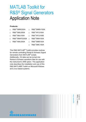
Using the ToolkitAt this point, the toolkit is complete, and you should have a set of actions to helpincrease your readiness for extreme weather events. You may want to set a timein the future (e.g., 6 months or 1 year) to re-complete the toolkit and measureyour progress.In addition, you can use the Impacts Tracking Module (see Step 6) to track thecosts and impacts of weather events as they occur over time.Step 6. Track impacts over timeThe AWARE Toolkit also includes a standalone Impacts Tracking Module that airports canuse to track the costs and impacts of weather events as they occur over time. Many airports donot have systems in place to monitor how much staff time, equipment, materials, and otherresources they spend preparing for or responding to weather events, except in the case of themost severe events with disaster declarations or major insurance claims. This tool is intendedto provide airports with a means to track costs from events large and small over time so thatairports can make more informed investment decisions. Jump to Section 3.8 for instructions onusing the Impacts Tracking Module.3.6 Exposure Information ModuleThe Exposure Information Module provides information on historical extreme weather frequency by county. The module provides information about the frequency of weather event typesin the airport’s county, adjacent counties, and region and, based on this information, identifiesspecific weather events that are “rare but plausible” because, as determined in the earlier researchstages of the project, these are the events for which airports are least likely to be prepared. These“rare but plausible” event types are recommended for evaluation in the remainder of the toolkit,although users are free to add or subtract from the recommended event type list. The process forusing this module is in the following subsections.3.6.1 Select Location Review module background information on the first tab. Click Next. On the Location Selection tab, look up your location either by airport IATA code or zip code. Once you have selected your IATA code or zip code from the drop-down menu, press Next.3.6.2 Review Results3.6.2.1 Extreme Events OverviewThe Extreme Events Overview tab (see Figure 3-3) shows an overview of how frequently thedifferent types of weather events occur in your county, compared to a national average (based onthe NOAA Storm Report database from 1996–2013). The graph on the right shows events thathave not occurred in your county, but have occurred in adjacent counties.Events that are recommended for further study are those that are “rare but plausible” for thelocation. “Rare but plausible” is defined as occurring fewer than once every 5 years in the airport’s county or occurring in adjacent counties without occurring in the airport’s county duringthe available time period.TK-13
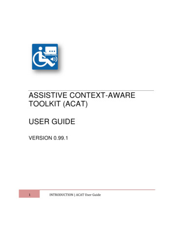
TK-14Addressing Significant Weather Impacts on Airports: Quick Start Guide and ToolkitFigure 3-3. Example outputs from exposure information module (extreme events overview).Click the Next button.3.6.2.2 Detailed ResultsThe Detailed Results page provides additional information (see Figure 3-4). For each event,the page provides Number of events from 1996 to 2013 for the selected county, adjacent counties, and the coun-ty’s FAA region. National map of event frequency. Click the map icon to view a map showing how often eachevent type has occurred in the United States, at the county level. This information may behelpful in identifying airports that frequently experience weather events that you have lessexperience with. Whether there have been any major disaster declarations in your county or adjacent counties(between 1996 and 2013). Whether the event is recommended for further study (red dot) or not (gray dot or pink dot),based on whether the event is “rare but plausible” as defined above.Additional information is also provided for flooding.Click the Next button.3.6.2.3 Additional InformationThe Additional Information page shows results from the ACROS climate tool, developedunder ACRP Project 02-40 and discussed in ACRP Report 147 (Figure 3-5). Because the AWAREToolkit does not project how climate change may affect the frequency of historical weather events,it provides projected changes in frequency for several climate variables using the ACROS climatetool. Some AWARE event types do not match the types in the ACROS tool and are thereforegreyed-out in the tool. Projected changes in frequency are indicated using up and down arrows.3.6.3 Select and Export Event Types Based on the previously presented information, decide which weather events you want toreview readiness for in the remainder of the toolkit. The recommended events will be preselected by default, but you can choose to add or subtract events from this list using the
Using the ToolkitFigure 3-4. Example outputs from exposure information module (detailed results).Figure 3-5. Exposure module, additional information.TK-15
TK-16Addressing Significant Weather Impacts on Airports: Quick Start Guide and ToolkitFigure 3-6. Exposure module, export button.checkboxes provided. Depending on regional geography and topography, weather events thatoccur in adjacent counties may not always be plausible in the airport’s location. Use your ownjudgment to determine whether it is appropriate to review readiness for event types that occurin adjacent counties. Press the Click to Export button (Figure 3-6) to export the recommended event types to theremaining toolkit files.Click the Save and Return to AWARE Toolkit button.Click here to go back to Full Toolkit User, AWARE Coordinator instructionsClick here to go back to Full Toolkit User, Functional Area Manager instructionsClick here to go back to Small Airport Toolkit User instructions3.7 Readiness ModulesThe readiness modules, available for six airport functional areas and small airports, areintended to provide practical, implementable information for operations managers and staff.In each module, users can Select weather event types (these may be pre-selected based on the Exposure InformationModule, and users have another opportunity to add or remove weather event types). Assess their readiness to respond to each weather event type. For each weather eventtype selected, as well as general weather events, the tool provides a list of best practices and
Using the Toolkitaccompanying implementation steps for preparing for, responding to, and recovering fromthe weather event. Users check off the activities they are already completing. Review their readiness ratings. The tool then provides qualitative ratings (on a scale of verylow to very high) of the airport’s readiness for each event type and by stage (e.g., planning,mitigation, response, and recovery). These ratings are based on the number of best practicesbeing taken at the airport. Users can also override the default rating if they believe that extenuating factors indicate a different readiness level than the tool output generates. Generate customized checklists. After the user has completed the readiness self-assessment(or even if they choose to skip that step), the module then provides checklists of best practicesand supporting implementation steps for preparing for, responding to, and recovering fromeach type of significant weather event selected by the user. These checklists contain activitiesthat have not been checked off by the user during the readiness self-assessment. Next to eachactivity, the user c
TK-4 Addressing Significant Weather Impacts on Airports: Quick Start Guide and Toolkit The seventh readiness module, Small Airports, is a consolidated, streamlined version of the full toolkit intended to be completed by one person. This may be more appropriate for air-ports with fewer staff, such as General Aviation (GA) airports or FAA small-hub airports.