Transcription
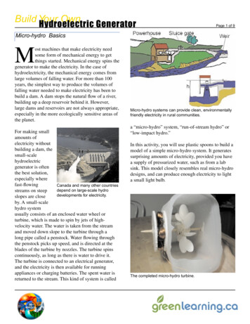
Z-53-2022Ö Ö Ö Ö ÖS Wilmington StMclendon S tight Cr eMccauley StLittle BlueBright Hope StvilleStFayetteG reenGas LDrKeeter CenterCX-3-CUPantopPDSummit AveIX-3s StIHeFayGreen StS Saunders StStProspect Avett eStlevilMaywood AveR-6NX-3-PLCMveit ACMCX-40-UL-CUmmSuGilbert AveCX-3-PLCity Farm Rd 801,040FeetPlum StCX-40-UL-CUIX-3-PLSHOD-2lmingtonevi l lIX-3teFayetPenmarc DrIX-3-CUS WiNX-3-PLks StWater WorStCX-3-PL0IHÖ Ö Ö Ö ÖS Blount StS Dawson StCt70Ö Ö NCODÖ ÖÖ Ö SouthÖ Park Ö ÖÖ Ö Ö ÖÖ Ö Ö Ö PDÖÖ Ö Ö ÖÖ Ö Ö Ö ÖÖ Ö Ö ÖÖ Ö Ö ÖHokeÖy Ln ÖÖthoritÖÖStSt ekRX-3R-10anS Blou n tIX-3OldMlysAly CtPDAuExisting ZoningR-6St Bluff S tWalker StLocation(1) 1500 S Wilmington St, (2) 15 Summit Ave, (3) 0 Water Works St43.89 acres§ § 540§ 540540§ 540§ § § § § § § § §§ 40R-6RX-5-UL (1) & RX-4-UL (2&3)Map by Raleigh Department of Planning and Development (shaughnessys): 6/13/20225404404404044040874087
WiRezoning Application and Checklist\Planning and Development Customer Service Center * One Exchange Plaza, Suite 400 Raleigh, NC 27601 919-996-2500RaleighPlease complete all sections of the form and upload via the Permit and Development Portal (permitportal.raleighnc.gov).Please see page 18 for information about who may submit a rezoning application. A rezoning application will not beconsidered complete until all required submittal components listed on the Rezoning Checklist have been received andapproved. For questions email rezoning@raleighnc.gov.Rezoning RequestRezoningX REGeneral UseConditional UseMaster Plan Text change to zoning conditionsExisting zoning base district: R-6Height:Proposed zoning base district: RXHeight: 4,5 (See Exhibit 1)Office Use OnlyRezoning case #Frontage:Overlay(s):Frontage: ULOverlay(s):Helpful Tip: View the Zoning Map to search for the address to be rezoned, then turn on the 'Zoning' and 'Overlay'layers.If the property has been previously rezoned, provide the rezoning case number:General InformationDate: Date amended (1):Date amended (2):Property address: 1500 S Wilmington St, 15 Summit Ave, 0 Water Works StProperty PIN: 1703614590,1703516283,1703503926Deed reference (book/page): 3218/360, 8363/2187, 13269/559Nearest intersection: Fayetteville sywater Works St, Summit Ave/Waterworks St!For planned developmentapplications onlyProperty size (acres): 43.89Total units:Total square footage:Total parcels:Total buildings:Property owner name and address: Tansy Hayward, Deputy City Manager, City of RaleighProperty owner email: Tansy. Hayward@raleighnc.govProperty owner phone: 919-996-3000Applicant name and address: Matthew Klem, One Exchange Plaza Suite 300Applicant email: Matthew.Klem@raleighnc.govApplicant phone: 919-996-4637Applicant signature(s):Additional email(s): Kenneth.Bowers@raleighnc.gov, bynum.walter@raleighnc.govBy Sarah Shaughnessy at 10:41 am, Jun 09, 2022Page lof 11REVISION 07.20.21raleighnc.gov
Conditional Use District Zoning ConditionsZoning case #:Date submitted:Existing zoning:Proposed zoning:Office Use OnlyRezoning case #Narrative of Zoning Conditions OfferedThe property owner(s) hereby offers, consents to, and agrees to abide, if the rezoning request isapproved, the conditions written above. All property,owners must sign each condition page. This pagemay be photocopied if additional spasneeded.Property Owner(s) Signature:Printed Name(s):Page 2 of 11Ladi,TansyLi On wooedREVISION 07.20.21raleighnc.gov
Rezoning Application Addendum #1Comprehensive Plan AnalysisThe applicant is asked to analyze the impact of the rezoning request and itsconsistency with the Comprehensive Plan. The applicant is also asked toOffice Use OnlyRezoning case #explain how the rezoning request is reasonable and in the public interest.Statement of ConsistencyProvide brief statements regarding whether the rezoning request is consistent with the future land use designation,the urban form map, and any applicable policies contained within the 2030 Comprehensive Plan.The request, while not consistent with current Future Land Use designation, is consistent with theFuture Land Use designations proposed through the Dix Edge Area Study and the community input thatmade affordable housing construction the priority in this area.The request includes and Urban Limited frontage which is consistent with the Transit Station Area andCore Transit Area Urban Form Map designations.The request is consistent with multiple policies in the 2030 Comprehensive Plan:Policy LU 4.6 Transit-Oriented Development, Policy LU 4.7 Capitalizing on Transit Access, Policy LU4.8 Station Area Land Uses, Policy LU 4.13 Land Acquisition for Affordable Housing, Policy LU 8.1Housing Variety, Policy LU 8.11 Development of Vacant Sites, Policy UD 1.10 Frontage, Policy UD 7.3Design Guidelines, Policy UD 8.1 Transit-Oriented Development. Additionally, the request is consistentwith the draft recommendations and policies of the Dix Edge Area Study.Public BenefitsProvide brief statements explaining how the rezoning request is reasonable and in the public interest.The proposed zoning changes are consistent with the above comprehensive plan policies andreasonable and in the public interested because the request will allow more people to live and work inthe core of the city within convenient walking distance to future high-quality transit. Allowing forincreased housing and providing subsidy to allow for a range of incomes in this area will increase thepotential housing opportunities in an area that is in high demand and will help advance the city's goal ofaddressing climate change by encouraging people to walk, bike, or take transit to accomplish everydayactivities.Page 3 of 11REVISION 07.20.21raleighnc.gov
Rezoning Application Addendum #2Impact on Historic ResourcesThe applicant is asked to analyze the impact of the rezoning request onhistoric resources. For the purposes of this section, a historic resource isdefined as any site, structure, sign, or other feature of the property to berezoned that is listed in the National Register of Historic Places or designatedOffice Use OnlyRezoning case #by the City of Raleigh as a landmark or contributing to a Historic OverlayDistrict.Inventory of Historic ResourcesList in the space below all historic resources located on the property to be rezoned. For each resource, indicate howthe proposed zoning would impact the resource.The sites do not contain any historic resources and will not impact any historic resources.Public MitigationProvide brief statements describing actions that will be taken to mitigate all negative impacts listed above.Page 4 of 11REVISION 07.20.21raleighnc.gov
Design GuidelinesThe Applicant must respond to the Urban Design Guidelines contained in the 2030 Comprehensive Plan if:a)b)The property to be rezoned is within a "City Growth Center", “Mixed-Use Center’, or “Transit StationAreas”, OR;The property to be rezoned is located along a "Main Street" or "Transit Emphasis Corridor" as shown onthe Urban Form Map in the 2030 Comprehensive Plan.Policy UD 7.3:The Design Guidelines in Table UD-1 shall be used to review rezoning petitions and development applications formixed-use developments; or rezoning petitions and development applications along Main Street and TransitEmphasis Corridors or in City Growth, TOD and Mixed-Use Centers, including preliminary site plans anddevelopment plans, petitions for the application of Downtown Overlay Districts, Planned Development Districts, andConditional Use zoning petitions.The Applicant must respond to the Downtown Urban Design Guidelines contained in the 2030 ComprehensivePlan if:a)The property to be rezoned is within "Downtown" as shown on the Urban Form Map in the 2030Comprehensive Plan.Policy DT 7.18:The design guidelines in Table DT-1 shall be used to review rezoning, alternative means of compliance, special usepermits, and planned development master plan applications in downtown.Please click here to download the Design Guidelines Addendum if required.Urban Form Designation: Click here to view the Urban Form map.Please continue to the next page for the Rezoning Checklist Submittal Requirement.Page 5 of 11REVISION 07.20.21raleighnc.gov
Rezoning Checklist (Submittal Requirements)To be completedby staffTo be completed by ApplicantGeneral Requirements — General Use or Conditional Use Rezoning:Yes N/A O} 0/0}iifisrd thorough fst eview bythe Cyof aleghao eeeees raioteistaningthisaside,itYes No NAwiC][ 3. Neighborhood meeting notice and reportEJE]4. Rezoning application review fee (see Development Fee Guide for rates).EJEJ2. Pre-application conferenceEL]5. Completed application submitted through Permit and Development PortalimEILELC]LC]LIL]LI6. Completed Comprehensive Plan consistency analysisE]E]LI7. Completed response to the urban design or downtown design guidelinesE]LE][ bEeeib tdouetaont9. Trip generation study10. Traffic impact analysisFor properties requesting a Conditional Use District:11. Completed zoning conditions, signed by property owner(s)If applicable, see page 18:42. Proof of Power of Attorney or Owner AffidavitFor properties requesting a Planned Development or Campus District:13. Master plan (see Master Plan submittal requirements)For properties requesting a text change to zoning conditions:44. Redline copy of zoning conditions with proposed changes15. Proposed conditions signed by property owner(s)EJLJE]O/O O}OCOo COL]LlLIE]Yes N/A Yes No N/A LE]Yes N/A Yes No N/ALIL] L]L]Yes No N/AYes N/A Yes N/A E]Yes No NALIL][ L]L]LIL]ElPlease continue to the next page for the Master Plan Submittal Requirements checklist.Page 6 of 11REVISION 07.20.21raleighnc.gov
SasvtyUrban Design Guidelines Addendum\RaleighPlanning and Development Customer Service Center * One Exchange Plaza, Suite 400 Raleigh, NC 27601 919-996-2500Urban Design GuidelinesThe Applicant must respond to the Urban Design Guidelines contained in the 2030 Comprehensive Plan if:a)The property to be rezoned is within a "City Growth Center", “Mixed-Use Center’, or “Transit StationAreas”, OR;The property to be rezoned is located along a "Main Street" or "Transit Emphasis Corridor" as shown onthe Urban Form Map in the 2030 Comprehensive Plan.b)Policy UD 7.3:The Design Guidelines in Table UD-1shall be used to review rezoning petitions and development applications formixed-use developments; or rezoning petitions and development applications along Main Street and TransitEmphasis Corridors or in City Growth, TOD and Mixed-Use Centers, including preliminary site plans anddevelopment plans, petitions for the application of Downtown Overlay Districts, Planned Development Districts, andConditional Use zoning petitions.Urban Form Designation:Click here to view the Urban Form map.All mixed-use developments should generally provide retail (such as eating establishments, food stores,and banks), and other uses such as office and residential within walking distance of each other. Mixed usesshould be arranged in a compact and pedestrian-friendly form.Response: The Urban Limited Frontage will produce a compact and pedestrian orienteddevelopment pattern.Within all mixed-use areas, buildings that are adjacent to lower density neighborhoods should transition(height, design, distance, and/or landscaping) to the lower heights or be comparable in height and massing.Response: Transitions to lower scale neighborhoods will be provided according to the UDOneighborhood transition requirements.A mixed-use area’s road network should connect directly into the neighborhood road network of the3surrounding community, providing multiple paths for movement to and through the mixed-use area. In thisway, trips made from the surrounding residential neighborhood(s) to the mixed-use area should be possiblewithout requiring travel along a major street. Preferred and discouraged street networks.Response: The subject properties are within an established road network, and may add to theroad network through the development of 1500 S Wilmington Street.Streets should interconnect within a development and with adjoining development. Cul-de-sacs or dead-endstreets are generally discouraged except where topographic conditions and/or exterior lot line configurationsoffer no practical alternatives for connection or through traffic. Street stubs should be provided with4development adjacent to open land to provide for future connections. Streets should be planned with dueregard to the designated corridors shown on the Street Plan. Streets should connect adjacentdevelopments.Response: The subject properties are within an established road network, and may add to theroad network through the development of 1500 S Wilmington Street.Page 1 of 11REVISION 05.05.21raleighnc.gov
New development should be composed of blocks of public and/or private streets (including sidewalks).Block faces should have a length generally not exceeding 660 feet. Where commercial driveways are usedto create block structure, they should include the same pedestrian amenities as public or private streets.Response: The development of 1500 S Wilmington Street will likely break up the existing large blockface along Fayetteville Street, while the other two sites are located within established blocks.A primary task of all urban architecture and landscape design is the physical definition of streets and publicspaces as places of shared use. Streets should be lined by buildings rather than parking lots and shouldprovide interest especially for pedestrians. Garage entrances and/or loading areas should be located at theside or rear of a property.Response: The requested Urban Limited frontage will ensure that buildings line the street ratherthan parking lots.Buildings should be located close to the pedestrian-oriented street (within 25 feet of the curb), with off-streetparking behind and/or beside the buildings. When a development plan is located along a high-volumecorridor without on-street parking, one bay of parking separating the building frontage along the corridor is apreferred option.Response: The requested Urban Limited frontage will ensure buildings will be placed close tothe street.If the site is located at a street intersection, the main building of a complex or main part of a single buildingshould be placed at the corner. Parking, loading, or service should not be located at an intersection.Response: The requested Urban Limited frontage will ensure buildings will be placed close tothe street.To ensure that urban open space is well-used, it is essential to locate and design it carefully. The spaceshould be located where it is visible and easily accessible from public areas (building entrances, sidewalks).Take views and sun exposure into account as well.Response: High quality design with Eliza Pool Park in mind can be a component of the futureRFP.New urban spaces should contain direct access from the adjacent streets. They should be open along theadjacent sidewalks and allow for multiple points of entry. They should also be visually permeable from thesidewalk, allowing passersby to see directly into the space.10Response: The requested Urban Limited frontage will ensure buildings will provide multiplepoints of pedestrian access along adjacent streets.The perimeter of urban open spaces should consist of active uses that provide pedestrian traffic for thespace including retail, cafés, and restaurants and higher-density residential.11Response: The requested zoning would allow for small retail or restaurant uses at the corner oftwo public streets.A properly defined urban open space is visually enclosed by the fronting of buildings to create an outdoor“room” that is comfortable to users.12Response: The requested Urban Limited frontage will ensure buildings will be placed close tothe street achieving the desired "outdoor room" effect.Page 2 of 11REVISION 05.0.21raleighnc.gov
New public spaces should provide seating opportunities.13Response: n/aParking lots should not dominate the frontage of pedestrian-oriented streets, interrupt pedestrian routes, ornegatively impact surrounding developments.14Response: The requested Urban Limited frontage will ensure that buildings line the street ratherthan parking lots.Parking lots should be located behind or in the interior of a block whenever possible. Parking lots should notoccupy more than 1/3 of the frontage of the adjacent building or not more than 64 feet, whichever is less.15Response: The requested Urban Limited frontage will ensure that buildings line the street ratherthan parking lots.Parking structures are clearly an important and necessary element of the overall urban infrastructure, but,given their utilitarian elements, can have serious negative visual effects. New structures should merit the16same level of materials and finishes as that a principal building would. Care in the use of basic designelements can make a significant improvement.Response: The requested Urban Limited frontage will achieve this goal.Higher building densities and more intensive land uses should be within walking distance of transit stops,permitting public transit to become a viable alternative to the automobile.A?Response: There js a proposed Bus Rapid Transit stop within 1/4 mile of these sites.Convenient, comfortable pedestrian access between the transit stop and the building entrance should beplanned as part of the overall pedestrian network.18Response: any development would include pedestrian improvements to better facilitate walkingto the transit stop.All development should respect natural resources as an essential component of the human environment.19The most sensitive landscape areas, both environmentally and visually, are steep slopes greater than 15percent, watercourses, and floodplains. Any development in these areas should minimize intervention andmaintain the natural condition except under extreme circumstances. Where practical, these features shouldbe conserved as open space amenities and incorporated in the overall site design.Response: a jarge portion of the subject properties are within floodplains. Floodplains will notbe developed.20All development should incorporate high-quality, productive landscapes that serve multiple functions. Suchfunctions include noise mitigation and absorption; capturing and cleaning of particulate matter; collectionand filtering of stormwater; and reduction of the urban heat island effect. Strategies include green walls,trellises, carefully planted trees, green infrastructure, and green roofs.Response: These elements can be included in the RFP after the properties are rezoned.Page 3 of 11REVISION 05.0.21raleighnc.gov
It is the intent of these guidelines to build streets that are integral components of community design. Publicand private streets, as well as commercial driveways that serve as primary pedestrian pathways to building21entrances, should be designed as the main public spaces of the city and should be scaled for pedestrians.Response: The requested Urban Limited frontage will ensure buildings will provide multiplepoints of pedestrian access along adjacent streets.Sidewalks should be 5-8 feet wide in residential areas and located on both sides of the street. Sidewalks incommercial areas and other areas where walkability is a focus should be a minimum of 14-18 feet wide to22accommodate sidewalk uses such as vendors, merchandising, and outdoor seating.Response: The requested Urban Limited Frontage requires a minimum 8-foot sidewalk.Streets should be designed with street trees planted in a manner appropriate to their function. Commercialstreets should have trees that complement the face of the buildings and that shade the sidewalk.Residential streets should provide for an appropriate tree canopy, which shadows both the street and23sidewalk and serves as a visual buffer between the street and the home. The typical width of the streetlandscape strip is 6-8 feet. This width ensures healthy street trees, precludes tree roots from breaking thesidewalk, and provides adequate pedestrian buffering. Street trees should be at least 6 %” caliper andshould be consistent with the city’s landscaping, lighting, and street sight distance requirements.Response: The requested Urban Limted Frontage requires a minimum 6-foot planting strip.Buildings should define the streets spatially. Proper spatial definition should be achieved with buildings orother architectural elements (including certain tree plantings) that make up the street edges aligned in a24disciplined manner with an appropriate ratio of height to width.Response: The requested Urban Limited frontage will produce a compact and pedestrianoriented development pattern.The primary entrance should be both architecturally and functionally on the front facade of any buildingfacing the primary public street. Such entrances should be designed to convey their prominence on the25fronting facade.Response: The requested Urban Limited frontage will ensure buildings will provide multiplepoints of pedestrian access along adjacent streets.The ground level of the building should offer pedestrian interest along sidewalks. This includes windows,entrances, and architectural details. Signage, awnings, and ornamentation are encouraged.26Response: The requested Urban Limited frontage will produce a compact and pedestrianoriented development pattern.The sidewalks should be the principal place of pedestrian movement and casual social interaction. Designsand uses should be complementary to that function.27Response: The requested Urban Limited frontage will produce a compact and pedestrianoriented development pattern.Page 4 of 11REVISION 05.0.21raleighnc.gov
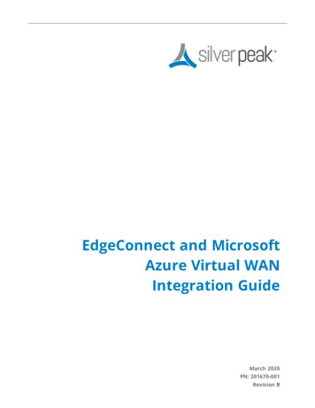
Rezoning Exhibit 1POC TeCSExisting ZoningProposed ZoningSite #1500 S Wilmington StResidential-6 (R-6)Residential Mixed Use-5 stories-Urban Limited 1(RX-5-UL)15 Summit AveResidential-6 (R-6)Residential Mixed Use-4 stories-Urban Limited 2(RX-4-UL)0 Waterworks StResidential-6 (R-6)Residential Mixed Use-4 stories-Urban Limited 3(RX-4-UL)1j5aq75 HlounhTTS defoodleigh—Ti5 Wilmington se5 Wiimangion siaaea SLpscad(eastSupe sendTinch equals 400 feetthe most cumeet and accurate information possi,Howeres, the maps are produced for information purposes.re provkted for the data theewin, hs wse,or ks interpretation,
Dix Edge City-Initiated Pre-Submittal Meeting Rezoning NotesDate: March 8, 2022, 5:30 pm via ZoomCity Staff: Matthew Klem, JP Mansolf, Mark Perlman, Lamont Taylor, Larry JarvisAttendees: Deb McCutcheon, Hal Sanborn, Cindy Sanborn, Monty Taylor, Kathy Johnson, Chris Powers,David Bracken, 919-607-4242Notes:Staff presented on the rezoning request and process:Origin from Dix Edge StudyWhat is zoning?Rezoning processDescribed the properties being rezonedDescribed the rezoning districts being requestedDescribed future Bus Rapid Transit serviceQuestions:Will the housing be rental?oOyes that is the plan nowWhat is the mixed-use componentoRX zoning allows for mixed use development, but it is not required, and its not theintention at this time to have a non-residential use for thesesites.Subsidized housing would income restricted.How would the City address potential negative impacts of affordable housing?o.There is no evidence that there would be increased crime with new affordable housing.oThe city is always looking for a high quality partner to develop affordable housing sitesthat have a track record of high quality development.Traffic Calming projects — need more information and will bring to future meetingsWhy 5 stories on Fayetteville Street, and how many units on Fayetteville stoLooking at potentially 340 units. The final development may not end up being thatmuch. Looking at a minimum of 240 units on the Fayetteville/Wilmington parcel.AMI Target?oLooking at targeting an average 60% AMI. A range of incomes would be served thatwould end up averaging at 60% AMI.How many parking spots?oParking will be determined according to minimum requirements for subsidized housing.We're feeling blind sided by this. We were more worried about the transition of DowntownSouth to the neighborhood.oThe number one comment we heard through the study was affordability.oWill provide more information on trip generation through the rezoning processComment: Mixed transportation is all well and good, but as the development is right acrossfrom my house, am trying to assess the impact on Fayetteville St and ability to get out of my
driveway, not to mention the loss of the beautiful natural wooded setting.getting used to the shock.As David indicated,Any information that is planned for the old water works building. No specific plans as far as we know.Section 8 housing?oNot looking to do that here explicitly. Its unlikely that we would see a proposal for acomplete Section 8 project.Thanks for explaining the intent of the city, it was very helpful.
February 23, 2022Dear Resident:You are invited to attend a neighborhood meeting on Tuesday March 8, 2022 from 5:30 p.m. to 6:30 p.m. Themeeting will be held virtually on zoom. To join the meeting, you can use the following link:httos://usO6web.zoom.us/j/82536101148, scan the QR code, or follow the Zoom instructions on the next page.The purpose of this meeting is to discuss a city-initiated rezoning of the following city-owned properties:PCGatirelate)4500 S Wilmington StResidential-6 (R-6)15 Summit AveResidential-6 (R-6)0 Waterworks StResidential-6 (R-6)Proposed ZoningResidential Mixed Use-5 stories-Urban Limited(RX-5-UL)1Residential Mixed Use-4 stories-Urban Limited 2(RX-4-UL)Residential Mixed Use-4 stories-Urban Limited(RX-4-UL) 3The intent of the rezoning is to position the city-owned property for development as subsidized affordable housing as animmediate action coming from the Dix Edge Area Study. For more information on the study, visit the Study Web Page.Following the rezoning process, the city will initiate a Request for Proposal (RFP) process to solicit interest in publicprivate-partnerships to develop affordable housing.Prior to filing a rezoning petition, the City of Raleigh requires that a neighborhood meeting be held for all residentswithin 500 feet of the area requested for rezoning. After the meeting a petition will be filed with the Planning andDevelopment Department.Information about the rezoning process is available online; visit www.raleighnc.gov and search for "Rezoning Process.”If you have further questions about the rezoning process, or would like to submit written comments after the meetingplease contact:Matthew KlemRaleigh Planning & Development(919) 996-4637matthew. klem@raleighnc.govCity of Raleigh (mailing address) Post Office Box 590 Raleigh, North Carolina 27602-0590
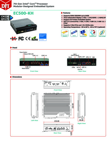
override ovende 1Ham WmMond-Ra *GitoertsAveCJ provertyProperty Being Rezoned:@‘ees nay efor pore stnoRaleigh Planning is inviting you to a scheduled Zoom meeting.Topic: Neighborhood Meeting for City Initiated Rezoning of 1500 S Wilmington St, 15 Summit Ave, and 0 Water WorksStTime: Mar 8, 2022 05:30 PMEastern Time (US and Canada)Join Zoom Meetinghttps://usO6web.zoom.us/j/82536101148?pwd a0xSWXBgSE9kaEtOVONTVWEzcnJsdz09Meeting ID: 825 3610 1148Passcode: 181743One tap mobile 13017158592, 82536101148# US (Washington DC) 13126266799, 82536101 148# US (Chicago)Dial by your location 1 301 715 8592 US (Washington DC) 1 312 626 6799 US (Chicago) 1 929 205 6099 US (New York) 1 253 215 8782 US (Tacoma) 1 346 248 7799 US (Houston) 1 669 900 6833 US (San Jose)Meeting ID: 825 3610 1148Find your local number: https://usO6web.zoom.us/u/kdF5fkQkC5City of Raleigh (mailing address) Post Office Box 590 Raleigh, North Carolina 27602-0590
ACOSTA, BRADLEY31 SUMMIT AVERALEIGH NC 27603-2449ADAMS, DWIGHTT117 PROSPECT AVERALEIGH NC 27603-2445AQUA EMPIRE LLC133 FAYETTEVILLE ST STE 600RALEIGH NC 27601-2911ARCHIVE DEVELOPMENT LLC105 CASHWELL DRGOLDSBORO NC 27534-7521CARGILL INCORPORATEDPO BOX 5626MINNEAPOLIS MN 55440-5626COOPER, BRYANT1121 FAYETTEVILLE STRALEIGH NC 27601-2526COOPER, CATHERINE E1121 FAYETTEVILLE STRALEIGH NC 27601-2526CREST, WINDSOR303 BATHGATE LNCARY NC 27513-5565DUKE ENERGY PROGRESS INCTAX DEPT - DEC41B550 S TRYON STCHARLOTTE NC 28202-4200FIFTEEN THOMAS LLCPO BOX 25367RALEIGH NC 27611-5367FIND AN ACORN LLC10014 CHAPEL HILL RDMORRISVILLE NC 27560-9399FOX, LISA COURTNEY BRACKEN, DAVIDBLANEY27 SUMMIT AVERALEIGH NC 27603-2449GAUTHIER, SANDRA111 GILBERT AVERALEIGH NC 27603-2419GUADALUPE, FELIPE SILVERIO105 PROSPECT AVERALEIGH NC 27603-2445GUPTA, BHOLA N GUPTA, RADHA L3316 BOULDER CTRALEIGH NC 27607-3111GUPTA, SANJAI K3316 BOULDER CTRALEIGH NC 27607-3111HACHMEISTER, MARIAH C147 GILBERT AVERALEIGH NC 27603-2419HARPER, MATTHEW1535 CARALEIGH MILLS CT APT 205RALEIGH NC 27603-6456HARPER, MATTHEW HARPER, JENNY312 E CABARRUS STRALEIGH NC 27601-1836HOBBS, DAVID G HOBBS, HELEN R414 PIERCE RDGARNER NC 27529-7912HORTON, ANTHONY1345 TURNER FARMS RDGARNER NC 27529-9331HOUSING AUTH CITY OF RALEIGHGOVERNMENT HOUSINGDEVELOPMENT900 HAYNES STRALEIGH NC 27604-1462HOUSING AUTHORITY CITY OF RALEIGH900 HAYNES STRALEIGH NC 27604-1462JONES, MAMIE THORPE YEARGINMCCULLERS, WILLIE CATHERINEYEARGINPO BOX 21013GREENSBORO NC 27420-1013KELLAGHER, MARY P12 GILBERT AVERALEIGH NC 27603-2418LAWRENCE, FAYE66 SUMMIT AVERALEIGH NC 27603-2450LEGGETT, BRENDA D35 SUMMIT AVERALEIGH NC 27603-2449JEB RENTALS, LLCPO BOX 27761RALEIGH NC 27611-7761KOPSA, THOMAS A KOPSA, CHANCE N121 GILBERT AVERALEIGH NC 27603-2419ANDREWS,DAVID RAY JR ANDREWS,BRENDA B5405 CHASSCOT CTRALEIGH NC 27606-5702
LET CORPORATION1117 FULLER STRALEIGH NC 27603-2217MAKGILL, DIANE C1535 CARALEIGH MILLS CT APT 141RALEIGH NC 27603-6455MCCUTCHEON, DEB100 SUMMIT AVERALEIGH NC 27603-2461MCKNITT AND ASSOCIATES LLC1526 S BLOUNT STRALEIGH NC 27603-2508MCMILLAN, JANA527 POWELL DRRALEIGH NC 27606-1621MENDOZA, JAVIER BENITEZ BENITEZ,ESPERANZA VASAVES112 GILBERT AVERALEIGH NC 27603-2420MK SOUTH III LLC1020 DICKINSON CIRRALEIGH NC
Please complete all sections of the form and upload via the Permit and Development Portal (permitportal.raleighnc.gov). Please see page 18 for information about who may submit a rezoning application. . 4.8 Station Area Land Uses, Policy LU 4.13 Land Acquisition for Affordable Housing, Policy LU 8.1 Housing Variety, Policy LU 8.11 Development .