Transcription
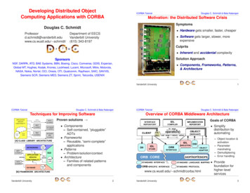
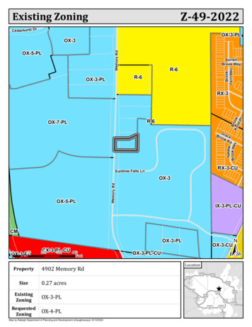
Z-49-2022Existing ZoningCedar hurst DrOX-3-PLOX-3Memory RdSorrellBrook WayR-6BrookFern WayOX-5-PLR-6OX-3-PLBrKn ookollPlRX-3R-6OX-7-PLNatalieBrook WayGBro raceokRdRX-3-CUSunbow Falls LnOX-5-PLMemory RdOX-3IX-3-PL-CUCM tedZoningCX-3-PL-CU220330440Feet4902 Memory Rd0.27 acresOX-3-CUOX-3-PL-CUR-10Location§ § 540§ 540540§ 540§ § § § § § § § §§ 40OX-3-PLOX-4-PLMap by Raleigh Department of Planning and Development (shaughnessys): 6/13/20225404404404044040874087
Rezoning Application and ChecklistPlanning and Development Customer Service Center One Exchange Plaza, Suite 400 Raleigh, NC 27601 919-996-2500Please complete all sections of the form and upload via the Permit and Development Portal (permitportal.raleighnc.gov).Please see page 11 for information about who may submit a rezoning application. A rezoning application will not beconsidered complete until all required submittal components listed on the Rezoning Checklist have been received andapproved. For questions email rezoning@raleighnc.gov.Rezoning RequestRezoningType General useConditional useMaster planText change to zoning conditionsExisting zoning base district: OXProposed zoning base district: OXHeight: 3Height: 4OFFICE USE ONLYRezoning case #Frontage: PLOverlay(s):Frontage: PLOverlay(s):Helpful Tip: View the Zoning Map to search for the address to be rezoned, then turn on the 'Zoning' and 'Overlay'layers.If the property has been previously rezoned, provide the rezoning case number:General InformationDate: April 19, 2022Date amended (1):Date amended (2):Property address: 4902 Memory Rd., Raleigh, NC 27609Property PIN: 1716530394Deed reference (book/page): 018740 / 01867Nearest intersection: Sunbow Falls LnFor planned developmentapplications only:Total units:Property size (acres): .27Total square footage:Total parcels:Total buildings:Property owner name and address: 51 Seven Group LLC, PO Box 1274, Buda, TX 78610Property owner email: contact@51sevengroup.emailProperty owner phone: 858 348 2024Applicant name and address: 51 Seven Group LLC, PO Box 1274, Buda, TX 78610Applicant email: contact@51sevengroup.emailApplicant phone: 858 348 2024Applicant signature(s):Additional email(s):Page 1 of 15REVISION 10.27.20raleighnc.gov
Conditional Use District Zoning ConditionsZoning case #:Date submitted:Existing zoning:Proposed zoning:OFFICE USE ONLYRezoning case #Narrative of Zoning Conditions OfferedThe property owner(s) hereby offers, consents to, and agrees to abide, if the rezoning request is approved, theconditions written above. All property owners must sign each condition page. This page may be photocopied ifadditional space is needed.Property Owner(s) Signature:Printed Name:Page 2 of 15REVISION 10.27.20raleighnc.gov
Rezoning Application Addendum #1Comprehensive Plan AnalysisThe applicant is asked to analyze the impact of the rezoning request andits consistency with the Comprehensive Plan. The applicant is also askedto explain how the rezoning request is reasonable and in the publicinterest.OFFICE USE ONLYRezoning case #Statement of ConsistencyProvide brief statements regarding whether the rezoning request is consistent with the future land usedesignation, the urban form map, and any applicable policies contained within the 2030 Comprehensive Plan.This rezoning request is consistent with the future land use designation of "Office & Residential Mixed Use."comprehensive plan:From the 2030Mixed Use Categories Office & Residential Mixed UseThis category is applied primarily to frontage lots along major streets where low-density residential uses are no longer appropriate, aswell as office parks and developments suitable for a more mixed-use development pattern. This category encourages a mix ofresidential and office use. Retail not ancillary to employment and/or residential uses is discouraged so that retail can be moreappropriately clustered and concentrated in retail and mixed-use centers at major intersections and planned transit stations. OX is theclosest corresponding zoning district. Heights would generally be limited to four stories when near neighborhoods, with additionalheight allowed for larger sites and locations along major corridors where adjacent uses would not be adversely impacted. Higherimpact uses such as hotels and hospitals are not contemplated or recommended in this land use category except as limited uses inappropriate locations.Public BenefitsProvide brief statements explaining how the rezoning request is reasonable and in the public interest.The rezoning request is consistent with the city of Raleigh policy LU 1.2 because it complies with Raleigh's future land use map.The rezoning request is consistent with the city of Raleigh policy LU 2.2 because the request to increase the allowed height of futuredevelopment would increase the potential for compact development.The rezoning request is consistent with the city of Raleigh policy LU 4.4 because the request would encourage development nearservices found in a commercial mixed use district.The rezoning request is consistent with the city of Raleigh policy LU 4.7 because the request would encourage development within1/3 mile of both the Falls of Neuse Road and East Millbrook Road bus stops.The rezoning request is consistent with the city of Raleigh policy LU 8.6 because it would encourage development on vacant land.The rezoning request is consistent with the city of Raleigh policy H 1.8 because the new zoning would encourage development of agreater variety of housing types.Page 3 of 15REVISION 10.27.20raleighnc.gov
Rezoning Application Addendum #2Impact on Historic ResourcesThe applicant is asked to analyze the impact of the rezoning request onhistoric resources. For the purposes of this section, a historic resource isdefined as any site, structure, sign, or other feature of the property to berezoned that is listed in the National Register of Historic Places ordesignated by the City of Raleigh as a landmark or contributing to aHistoric Overlay District.OFFICE USE ONLYRezoning case #Inventory of Historic ResourcesList in the space below all historic resources located on the property to be rezoned. For each resource, indicatehow the proposed zoning would impact the resource.There are no historic resources on the property to be rezoned.Proposed MitigationProvide brief statements describing actions that will be taken to mitigate all negative impacts listed above.Page 4 of 15REVISION 10.27.20raleighnc.gov
Urban Design GuidelinesThe applicant must respond to the Urban Design Guidelines contained in the 2030 Comprehensive Plan if:a) The property to be rezoned is within a "City Growth Center" or “Mixed-Use Center”, OR;b) The property to be rezoned is located along a "Main Street" or "Transit Emphasis Corridor" as shown on theUrban Form Map in the 2030 Comprehensive Plan.Urban form designation: Mixed Use Center1Click here to view the Urban Form Map.All Mixed-Use developments should generally provide retail (such as eating establishments, food stores,and banks), and other such uses as office and residential within walking distance of each other. Mixed usesshould be arranged in a compact and pedestrian friendly form.Response:Additional story will allow compact development. New sidewalk in front of the lot will enhance pedestrian access.2Within all Mixed-Use Areas buildings that are adjacent to lower density neighborhoods shouldtransition (height, design, distance and/or landscaping) to the lower heights or be comparable inheight and massing.Response:This lot is surrounded on all sides by Office Mixed Use zoning.3A mixed-use area’s road network should connect directly into the neighborhood road network of thesurrounding community, providing multiple paths for movement to and through the mixed-use area. In thisway, trips made from the surrounding residential neighborhood(s) to the mixed-use area should bepossible without requiring travel along a major thoroughfare or arterial.Response:Size of lot (0.27 acres) prevents addition of new roads.4Streets should interconnect within a development and with adjoining development. Cul-de-sacs or deadend streets are generally discouraged except where topographic conditions and/or exterior lot lineconfigurations offer no practical alternatives for connection or through traffic. Street stubs should beprovided with development adjacent to open land to provide for future connections. Streets should beplanned with due regard to the designated corridors shown on the Thoroughfare Plan.Response:No new roads are proposed at this time.5New development should be comprised of blocks of public and/or private streets (including sidewalks). Blockfaces should have a length generally not exceeding 660 feet. Where commercial driveways are used to createblock structure, they should include the same pedestrian amenities as public or private streets.Response:Size of lot (0.27 acres) and surrounding existing development prevents reduction of block face.6A primary task of all urban architecture and landscape design is the physical definition of streets and publicspaces as places of shared use. Streets should be lined by buildings rather than parking lots and shouldprovide interest especially for pedestrians. Garage entrances and/or loading areas should be located at theside or rear of a property.Response:There is currently no street curb or sidewalk in front of the property. Development will improve street by adding curb andsidewalk along Memory Road.Page 5 of 15REVISION 10.27.20raleighnc.gov
7Buildings should be located close to the pedestrian-oriented street (within 25 feet of the curb), with offstreet parking behind and/or beside the buildings. When a development plan is located along a highvolume corridor without on-street parking, one bay of parking separating the building frontage along thecorridor is a preferred option.Response:To be determined at site plan review. This lot is zoned PL and the size of lot (0.27 acres) limits design options.If the site is located at a street intersection, the main building or main part of the building should beplaced at the corner. Parking, loading or service should not be located at an intersection.Response:89This lot is not near an intersection.To ensure that urban open space is well-used, it is essential to locate and design it carefully. The spaceshould be located where it is visible and easily accessible from public areas (building entrances,sidewalks). Take views and sun exposure into account as well.Response:To be determined at site plan review. The small size of the lot (0.27 acres) ensures access will be visible from street.10New urban spaces should contain direct access from the adjacent streets. They should be open along theadjacent sidewalks and allow for multiple points of entry. They should also be visually permeable from thesidewalk, allowing passersby to see directly into the space.Response:To be determined at site plan review. The small size of the lot (0.27 acres) ensures visibility from street.The perimeter of urban open spaces should consist of active uses that provide pedestrian traffic for thespace including retail, cafés, and restaurants and higher-density residential.Response:1112Development will improve street by adding curb and sidewalk.A properly defined urban open space is visually enclosed by the fronting of buildings to create anoutdoor "room" that is comfortable to users.Response:To be determined at site plan review. The small size of the lot (0.27 acres) limits design options.New public spaces should provide seating opportunities.13Response:To be determined at site plan review. The small size of the lot (0.27 acres) limits design options for public seating.Page 6 of 15REVISION 10.27.20raleighnc.gov
Parking lots should not dominate the frontage of pedestrian-oriented streets, interrupt pedestrian routes,or negatively impact surrounding developments.14 Response:The small size of the lot (0.27 acres) ensures limited parking.Parking lots should be located behind or in the interior of a block whenever possible. Parking lots should notoccupy more than 1/3 of the frontage of the adjacent building or not more than 64 feet, whichever is less.15 Response:This lot is zoned PL and the size of lot (0.27 acres) limits design options.16Parking structures are clearly an important and necessary element of the overall urban infrastructure but,given their utilitarian elements, can give serious negative visual effects. New structures should merit thesame level of materials and finishes as that a principal building would, care in the use of basic designelements cane make a significant improvement.Response:Increasing allowed height of future development provides the option of incorporating parking within the building.Higher building densities and more intensive land uses should be within walking distance of transitstops, permitting public transit to become a viable alternative to the automobile.17 Response:The site is 0.3 miles from both the Falls of Neuse Road and East Millbrook Road bus stops.Convenient, comfortable pedestrian access between the transit stop and the building entrance should beplanned as part of the overall pedestrian network.18 Response:The small size of the lot (0.27 acres) ensures pedestrian access to city sidewalks.19All development should respect natural resources as an essential component of the human environment.The most sensitive landscape areas, both environmentally and visually, are steep slopes greater than 15percent, watercourses, and floodplains. Any development in these areas should minimize intervention andmaintain the natural condition except under extreme circumstances. Where practical, these featuresshould be conserved as open space amenities and incorporated in the overall site design.Response:There are no slopes greater than 15 percent, watercourses, or floodplains at this site.20It is the intent of these guidelines to build streets that are integral components of community design. Publicand private streets, as well as commercial driveways that serve as primary pedestrian pathways to buildingentrances, should be designed as the main public spaces of the City and should be scaled for pedestrians.Response:Size of lot (0.27 acres) prevents addition of new roads.Page 7 of 15REVISION 10.27.20raleighnc.gov
21Sidewalks should be 5-8 feet wide in residential areas and located on both sides of the street. Sidewalksin commercial areas and Pedestrian Business Overlays should be a minimum of 14-18 feet wide toaccommodate sidewalk uses such as vendors, merchandising and outdoor seating.Response:Development will improve street by adding curb and sidewalk.22Streets should be designed with street trees planted in a manner appropriate to their function. Commercialstreets should have trees which complement the face of the buildings and which shade the sidewalk.Residential streets should provide for an appropriate canopy, which shadows both the street and sidewalk,and serves as a visual buffer between the street and the home. The typical width of the street landscapestrip is 6-8 feet. This width ensures healthy street trees, precludes tree roots from breaking the sidewalk,and provides adequate pedestrian buffering. Street trees should be at least 6 1/4" caliper and should beconsistent with the City's landscaping, lighting and street sight distance requirements.Response:Development will improve city street by adding curb and sidewalk.2324Buildings should define the streets spatially. Proper spatial definition should be achieved with buildingsor other architectural elements (including certain tree plantings) that make up the street edges alignedin a disciplined manner with an appropriate ratio of height to width.Response:To be determined at site plan review. The small size of the lot (0.27 acres) limits design options.The primary entrance should be both architecturally and functionally on the front facade of any buildingfacing the primary public street. Such entrances shall be designed to convey their prominence on thefronting facade.Response:The structure on this site will comply with all UDO requirements for entrances and façades.The ground level of the building should offer pedestrian interest along sidewalks. This includeswindows entrances, and architectural details. Signage, awnings, and ornamentation are encouraged.Response:25Development on this site will comply with all UDO requirements for signage, awnings, and ornamentation.The sidewalks should be the principal place of pedestrian movement and casual social interaction. Designsand uses should be complementary to that function.Response:26Development will improve Memory Road by adding curb and sidewalk.Page 8 of 15REVISION 10.27.20raleighnc.gov
Rezoning Checklist (Submittal Requirements)To be completed bystaffTo be completed by ApplicantGeneral Requirements – General Use or Conditional Use RezoningYes1. I have referenced this Rezoning Checklist and by using this as aguide, it will ensure that I receive a complete and thorough first reviewby the City of Raleigh 2. Pre-application conference. 3. Neighborhood meeting notice and report 4. Rezoning application review fee (see Fee Guide for rates). 5. Completed application submitted through Permit and DevelopmentPortal 6. Completed Comprehensive Plan consistency analysis 7. Completed response to the urban design guidelines 8. Two sets of stamped envelopes addressed to all property owners ofarea to be rezoned and properties with 500 feet of area to be rezoned. N/A9. Trip generation study 10. Traffic impact analysis YesNoN/AFor properties requesting a Conditional Use District:11. Completed zoning conditions, signed by property owner(s). If applicable, see page 11:12. Proof of Power of Attorney or Owner Affidavit. For properties requesting a Planned Development or Campus District:13. Master plan (see Master Plan submittal requirements). For properties requesting a text change to zoning conditions:14. Redline copy of zoning conditions with proposed changes. 15. Proposed conditions signed by property owner(s). Page 9 of 15REVISION 10.27.20raleighnc.gov
Master Plan (Submittal Requirements)To be completed bystaffTo be completed by ApplicantGeneral Requirements – Master PlanYesN/AYesNoN/A1. I have referenced this Master Plan Checklist and by using this as aguide, it will ensure that I receive a complete and thorough first reviewby the City of Raleigh.2. Total number of units and square feet3. 12 sets of plans4. Completed application; submitted through Permit & Development Portal5. Vicinity Map6. Existing Conditions Map7. Street and Block Layout Plan8. General Layout Map/Height and Frontage Map9. Description of Modification to Standards, 12 sets10. Development Plan (location of building types)11. Pedestrian Circulation Plan12. Parking Plan13. Open Space Plan14. Tree Conservation Plan (if site is 2 acres or more)15. Major Utilities Plan/Utilities Service Plan16. Generalized Stormwater Plan17. Phasing Plan18. Three-Dimensional Model/renderings19. Common Signage PlanPage 10 of 15REVISION 10.27.20raleighnc.gov
NOTIFICATION LETTER TEMPLATEDate:Re: (SITE LOCATION)Neighboring Property Owners:You are invited to attend a neighborhood meeting on (MEETING DATE and TIME). The meetingwill be held virtually. You can participate online or by telephone. To participate, visit:(MEETING WEB ADDRESS)Or call:(MEETING PHONE NUMBER)The purpose of this meeting is to discuss a potential rezoning of the property located at (SITEADDRESS AND NEARBY LANDMARKS). This site is currently zoned (CURRENT ZONINGDISTRICT) and is proposed to be rezoned to (PROPOSED ZONING DISTRICT). (ANY OTHERRELEVANT DETAILS OF THE REQUEST.)Prior to the submittal of any rezoning application, the City of Raleigh requires that aneighborhood meeting be held for all property owners within 500 feet of the area requested forrezoning.Information about the rezoning process is available online; visit www.raleighnc.gov and searchfor “Rezoning Process.” If you have further questions about the rezoning process, pleasecontact:JP MansolfRaleigh Planning & Development(919)996-2180JP.Mansolf@raleighnc.govIf you have any concerns or questions about this potential rezoning I (we) can be reached at:(NAME)(CONTACT INFO)Sincerely,
ATTESTATION TEMPLATEAttestation StatementI, the undersigned, do hereby attest that the electronic verification documentsubmitted herewith accurately reflects notification letters, enclosures, envelopesand mailing list for mailing the neighborhood meeting notification letters asrequired by Chapter 10 of the City of Raleigh UDO, and I do hereby further attestthat that I did in fact deposit all of the required neighborhood meeting notificationletters with the US. Postal Service on the , day of , 2020. I dohereby attest that this information is true, accurate and complete to the best ofmy knowledge and I understand that any falsification, omission, or concealmentof material fact may be a violation of the UDO subjecting me to administrative,civil, and/or, criminal liability, including, but not limited to, invalidation of theapplication to which such required neighborhood meeting relates.Signature of Applicant/Applicant RepresentativeDateLetters were delivered to Sarah Shaughnessy for mailing
Date: May 17, 2022Re: 4902 Memory Rd., Raleigh, NC 27609Neighboring Property Owners:You are invited to attend a neighborhood meeting on May 31, 2022, at 5:30PM. The meeting willbe held in person at:Millbrook Exchange Community CenterMillbrook Exchange CC Room 11905 Spring Forest Rd.Raleigh, NC 27615The purpose of this meeting is to discuss a proposed rezoning of the property located at 4902Memory Rd., Property Identification Number 1716530394, just north of the Windsor FallsApartments. This site is currently zoned Office Mixed Use, three story, parking limited (OX-3-PL)and is proposed to be rezoned to Office Mixed Use, four story, parking limited (OX-4-PL).The City of Raleigh requires that a neighborhood meeting be held for all property owners within500 feet of the area requested for rezoning. After the meeting, a report will be submitted to theRaleigh Planning and Development Department. Any other person attending the meeting cansubmit written comments about the meeting.If you have further questions about the rezoning process, or would like to submit writtencomments after the meeting please contact:Sarah ShaughnessyRaleigh Planning & Development(919) 996-2234Sarah.shaughnessy@raleighnc.govIf you have any concerns or questions about this potential rezoning we can be reached by emailat contact@51sevengroup.email or by phone at 858 348 2024.Sincerely,51 Seven Group LLCPO Box 1274Buda, TX 78610
SUMMARY OF ISSUESA neighborhood meeting was held on May 31, 2022located at(date) to discuss a potential rezoning(property address). The4902 Memory Rd.neighborhood meeting was held at Millbrook Exchange Community Center, 1905 Spring Forest Rd.There were approximately 1(location).(number) neighbors in attendance. The general issues discussedwere:Summary of Issues:No issues were raised by the attendee.Page 13 of 15REVISION 10.27.20raleighnc.gov
ATTENDANCE ROSTERNAMEADDRESSIsabel Mattox (representing 51 Seven Group LLC)127 West Hargett St. Suite 500Hannah Reckhow (representing City Planning)Planning & Development, One Exchange Plaza, Suite 300Gregg Harper5004 Memory RoadPage 14 of 15REVISION 10.27.20raleighnc.gov
8. of . 15. REVISION 10.27.20. raleighnc.gov 21 . Sidewalks should be 5-8 feet wide in residential areas and located on both sides of the street. Sidewalks in commercial areas and Pedestrian Business Overlays should be a minimum of 14-18 feet wide to accommodate sidewalk uses such as vendors, merchandising and outdoor seating. Response: 22