Transcription
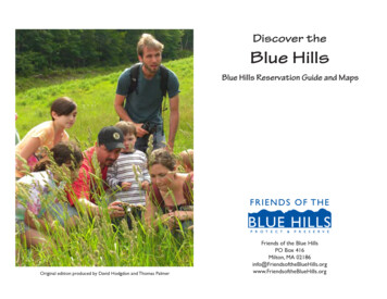
Discover theBlue HillsBlue Hills Reservation Guide and MapsFriends of the Blue HillsPO Box 416Milton, MA eBlueHills.orgOriginal edition produced by David Hodgdon and Thomas PalmerFriends of the Blue Hills1www.FriendsoftheBlueHills.org
IntroductionWhether you are a frequent sojourner in the Blue Hills, or a newvisitor, there is always something new to be explored in this inspiringlandscape. Among the 7,000 plus acres there are opportunities to hike,bike, ski, swim, climb and contemplate the simple beauty of nature. Onecan take a serpentine drive through the reservation, stopping to admireviews along the way, or accept the challenge of hiking the Skyline Trailfrom beginning to end.glimpse of the unusual mating dance of the American woodcock.You can spend your summers swimming at Houghton’s Pond, akettle pond formation, gift of the glacial age, or pack your rod for somefishing at Ponkapoag Pond. In the warmer months, try launching yourcanoe on the Neponset River at Fowl Meadow. When the precipitationturns to snow, revisit Fowl Meadow for flat, easy cross-country skiingor, alternatively, speed down the slopes at the Blue Hill Ski Area.For adventurous souls, there’s the challenge of biking Great BlueHill or rock climbing on the vertical walls at Quincy Quarries in thenorthernmost part of the park. Those seeking a workout can hike theSkyline Trail from Quincy to Canton, a hike offering much elevationchange and wonderful views. Even if you don’t consider yourself aserious hiker, you’ll still find easy rambles on trails that take you aroundHoughton’s Pond. Any time of year is a good time to take the childrento the Blue Hills Trailside Museum to see the creatures that live in thepark and learn about the Reservation’s rich history.The Blue Hills Reservation exists to provide recreation andenjoyment for all people and to preserve and protect this precioushabitat for all living things that call it home. The Friends of the BlueHills is a 1,000-member non-profit organization devoted to preservingand protecting the Blue Hills Reservation’s natural beauty, diversenatural habitats and many recreational opportunities. We invite youto join us in this mission by practicing good stewardship while in thereservation and by becoming a member. Enjoy this special place.With this guide, you can explore each of the sections of the park.As you explore the Reservation throughout the year you will find newdelights as each season transforms the landscape. In the spring, bringyour binoculars and head to Fowl Meadow in the 000s, where you arelikely to spot a pileated woodpecker and other colorful birds or catch aFriends of the Blue Hills2www.FriendsoftheBlueHills.org
About the Blue Hills ReservationThe Blue Hills Reservation encompasses approximately 7,000acres of woods, ponds, wetlands and elevated rock set aside by theCommonwealth of Massachusetts in 1893 for its citizens to use andenjoy. It is centered on the Blue Hills themselves, a long sweep ofsteep, stony ridges rising seven miles from Quincy’s historic granitequarries in the east to the massive dome of Blue Hill in Canton andMilton in the west. Although none of the peaks is so much as athousand feet high, they stand well above the surrounding lowlands,and dominate the landscape in all directions.to charm each of them. Though it would take a lifetime to explorethoroughly, much of it is right next to Boston, and it lies open on allsides. Legally speaking, it belongs to everyone, and it offers a standinginvitation to stretchyour legs and walkover the earth as if youowned it.The Reservationis managed for theCommonwealth bythe Department ofConservation andRecreation and is openfrom dawn to duskdaily throughout theyear. Now more than100 years old, it is thelargest component ofBoston’s peripheralpark system, and ithas become even moreprecious as the region’s population has grow significantly and moderndevelopment has reached out to Rt. 495 and beyond. Thanks to the BlueHills, there is no need to drive to the Berkshires or New Hampshire toget a sizable helping of the New England outdoors in its natural state.The Reservation was conceived by landscape architect CharlesEliot, as a contrast and counterpoint to metropolitan Boston’s thenexisting parks, such as Boston Common and Jamaica Pond, in thatNature, and not Art, would be its dominant theme. Instead of widelawns and manicured groves, it would feature deep forests, shaggycliffs, and free-running water. He was convinced that no city shouldbe without spacious tracts of dramatic natural scenery open to all, andsince this kind of scenery was rapidly vanishing around Boston’s turnof-the-century metropolis, he chose one of the richest remaining lodes,the Blue Hills, as the site for his largest park. Other properties acquiredunder his direction include Nantasket Beach and the Charles RiverEsplanade.Today his vision is largely intact, and the oasis he created in theBlue Hills continues to draw thousands into its delightfully hillywoods for an hour or a day. Containing portions of Boston, Dedham,Westwood, Canton, Milton, Randolph, Quincy and Braintree, theReservation is vast enough to absorb multitudes and intimate enoughFriends of the Blue Hills3www.FriendsoftheBlueHills.org
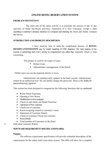
BLUE HILLS 2234124ATHLETICFIELD40864085423440824102DollLan are404941664096HemenwayPond41343171HemlDr ock405340131214405231313104 Squamaug Notch 105131552181101068771050winter66701186Closed in1002207210453090665068806891 DAccord Path560056111077LEGEND10571079ATHLETICFIELDSR U L E S A N D R E G U L AT I O N SDESTINATION TRAILS are marked with rectangles and are designedfor much longer and more strenuous day hikes. These are not loop trailsso plan transportation back to your starting point.5320Blue rectangles mark the popular Skyline which traverses the entireBlue Hills Range with many fantastic views. Note the north and southbranches in the western part of the reservation.Length: 9 miles Hiking Time: 4 to 7 hours5322Park open dawn to dusk.For the protection and enjoyment of the Blue Hills,the following are prohibited:LitteringOpen firesMetal detectorsAlcoholic beveragesPets, except on a leashHunting or trappingPosting or distributing leafletsCamping except at AMC Camp with permitMotorized vehicles, except on public roadsDisruptive conduct, including public nudityGroup use of 25 or more, except with a DCR permitDestruction or removal of vegetation, animals,structures, artifacts or other State property Off trail use without a permit In addition, the following activities are allowedin designated areas only: ParkingSporting activitiesMountain bicyclingCharcoal grills or fuel stovesNon-motorized boating at Ponkapoag PondSwimming at Houghton’s Pondwith lifeguard supervisionAll visitors must follow directions of Park personnelor Police. Any violations of these regulations may resultin arrest and/or fine per order of 302 Commonwealth ofMassachusetts Regulations 12.00Intersection Marker: The four digitnumbers seen on the map designatetrail intersections. Look for thecorresponding white wooden signswith black numbers on trees orposts along the trails.5218Reservation HeadquartersParkingLOOP TRAILS are marked with dots. Loop trails begin and end at the5370Canoe Launchsame point at designated parking areas as marked on the map.5380Restrooms (seasonal only)Green dots mark several woodland loops which allow you to enjoythe natural beauty of the reservation.Length: 2.4 to 4 miles Hiking Time: 2 to 2.25 hours5383Observation TowersStructureRed dots mark rugged, rocky loops over hilly terrain providing amore challenging hike.Length: 1 to 3 miles Hiking Time: 1 to 2.25 hours5413Narrow TrailWide TrailYellow dots mark short loops which enable you to enjoy parts of thereservation in a small amount of time.Length: 0.5 to 1 mile Hiking Time: 1 hour5360521653555420Paved RoadRailroadTown BoundaryDIRECTIONAL LOOP TRAILS are marked with triangles and both loopsbegin and end at the Houghton’s Pond main parking lot. These are designedas rolling routes for a fun mountain bike ride or long woodland hike. The trailsare marked in one direction only and are to be followed counter-clockwise.WetlandsPondBrook, RiverWhite triangles mark the Forest Path loop in the Houghton’s Pondsection. This rambling 6-mile loop creates a long woodland hikeor novice to intermediate mountain bike ride.Length: 6 milesATHLETICFIELDYellow triangles mark the Breakneck Ledge loop in the Great BlueHill section. This 4.5 mile loop provides a rocky, rugged and hillyexperience for the advanced mountain biker or avid hiker.Length: 4.5 milesSTAY ON DCR DESIGNATED TRAILS FOR SAFETY AND RESOURCE PROTECTIONContour Lines6 meter (19.7 ft) interval01 81 41 2SCALE IN MILESMAP PRINTED WITH SOY INK AND ON RECYCLED PAPER.COLORS MAY CHANGE IN BRIGHT LIGHT.DCR official map printed April 2016
Blue HillThe Blue Hill section is centered on Blue Hill itself, a 460-millionyear-old dome of granite porphyry which, at a mile wide and fiftystories high, is the largest chunk of rock anywhere around Boston.Massachusetts, an Algonquin name, translates as “At the Great Hill.”Four hundred years ago the local Native Americans used the term torefer to themselves. In adopting the name for their settlement, the BayColonists ensured that the entire state would be named after Blue Hill.crosses a small gully, honors the Reservation’s creator, Charles Eliot.It leads to the three-story fieldstone tower built in 1929 from whoseupper chamber much of eastern Massachusetts is visible on a clearday, highlighted by downtown Boston, and Massachusetts Bay. NewHampshire’s lonely giant, Mount Monadnock, may be in view sixtyseven miles to the northwest. Picnic tables are scattered under the roofof the stone-floored pavilion below.Wherever you enter the Blue Hill section, you’ll be going uphill,and the way can get rugged. Persist and you will eventually emerge onthe summit, which at 635 feet is by far the tallest of the Reservation’sdozen peaks. Although there is no car access to the top, you can ride upin style on the ski area’s chairlift on October weekends. in addition, theDCR, provides wheelchair access on request.The Reservation’s most popular year-round destination is theTrailside Museum on Rt. 138, just north of the ski area. Operated forthe DCR by MassAudubon, it maintains a substantial collection ofnative wildlife for educational purposes, and its exhibits display theReservation’s varied natural landscapes in detail. A full schedule ofweekend and evening programs is available.The broad, grassy trails of Blue Hill Ski, which opened in the late30’s, stripe Blue Hill’s western slope. Mechanical snowmaking wasinvented here, although most winters provide plenty of the naturalproduct. Amenities include a lodge, snack bar, and equipment rentals.Many of Boston’s skiers cut their teeth on Blue Hill.Follow Blue Hill River Rd to Hillside St around the southern edgeof Blue Hill from Rt. 138. In about two miles you’ll reach the DCR’sReservation Headquarters, a white frame house on the left, just up thehill from the State Police station. Here you can get maps, check theschedule of events, and have your questions answered by rangers.The summit is flat and is slowly reclothing itself in oak and pine.The turreted castle at its southern end houses the Blue Hill WeatherObservatory, a semi-automated station in continuous operation since 1885.Tours are available for groups and on a walk-in basis on most weekendsfrom February to November and by appointment year-round.The Blue Hill section also includes Wolcott, Houghton, Hemenwayand Hancock Hills, which combine to give it the highest averageelevation of any portion of the reservation. Runoff is swift, and thereare few ponds or permanent streams. But the section is rich with thehigh bluffs, bare ledges, and broad vistas for which the Reservation iscelebrated – they are strung along its upper trails in bunches. Onceyou’ve hiked past a few, you probably won’t want to come down.A short walk away at the summit’s northern end are the EliotMemorial Bridge Tower and Pavilion. The granite footbridge, whichFriends of the Blue Hills5www.FriendsoftheBlueHills.org
Friends of the Blue Hills6www.FriendsoftheBlueHills.org
Houghton’s PondThanks to its splendid beach on a spacious sand-bottomedpond, the Houghton’s Pond section is the summertime heart of theReservation.permitted, fishermen catch trout, perch, sunfish and hornpout from theshore.Just south of the Pond an abandoned portion of the original Rt128 runs east of the softball fields for a mile or so along the base of theHills before butting up against the embankment of the new Rt. 128 thatreplaced it. The old two-lane road provides a level surface for skiers,walkers and cyclists along Blue Hill River and its bordering mapleswamps.Twenty-five-acre Houghton’s Pond owes its existence to a hugeblock of ice that got stuck on the south side of the Hills as the lastglacier ebbed back across them about 15,000 years ago. Meltwaterslaid down deep beds of sand all around the block, and when it finallyvanished, it left a shelving basin like a window into the underlyingaquifer. The Pond remains cool and clear even in the hottest weather, asif recalling its origins.The northeast corner of Houghton’s Pond marks the gateway tothe rest of its section, which is heavily wooded and full of the ruggedheights typical of the Reservation as a whole. 449-foot Tucker Hill,topped with a fine group of windblown pines, is a moderate quartermile hike away. A half-mile further stands its taller companion, 496foot Buck Hill. Buck is well worth a visit, since it is unique among thehigh hills in being open on all sides near the top, with no ambitioustrees interrupting the view in any direction. If you live anywhere nearBoston, you may be able to see your house from Buck Hill.The Pond occupies a deep notch in the south-facing bulwark of theHills, and its level surroundings were farmed for generations beforetheir conversion to the Reservation. Today its broad north shore islargely reserved for swimmers, who come from Boston and elsewherein droves. Lifeguards are on duty in the summer months.The rest of the Pond is surrounded by wide lawns, open woods,ball fields, tennis courts, bathhouses, shady picnic grounds dottedwith barbecue stoves, and a stone-floored refreshment pavilion. Thepavilion, which was put on the State and National Historic Register in1980, was built in 1920 by Stickney and Austin. All of these featuresare within easy walking distance of each other. Although no boating isFriends of the Blue HillsMany of the people who have been coming to the Blue Hills foryears have never gone further than the Houghton’s Pond section.Perhaps this demonstrates the power of cool clear water.7www.FriendsoftheBlueHills.org
Friends of the Blue Hills8www.FriendsoftheBlueHills.org
ChickatawbutThe eastern section of Chickatawbut Road runs two miles alongthis section’s northern boundary from Rt. 28 in Milton to Willard St. inQuincy, paralleling the ridgeline along its gentle backside. Anywherealong here you can hike through to the crest, which is studded withrocky openings overlooking a carpet of treetops extending south to Rt.128. If you climb down into these trees, you are entering the greenestand wildest part of the Hills. The road is gated at both ends, and isclosed after dark.cluster of low cinderblock buildings where the Blue Hills TrailsideMuseum bases its day camps. The Air Force built the Center in thelate 1950’s as a radar installation for its 3rd Missile Battalion, and theairmen who lived here controlled the Nike anti-aircraft missiles housedin the silos two miles below in Randolph. Today both soldiers andmissiles are long gone, but the site itself is still not open to the publicdue to safety and contamination concerns. .Further east toward Quincy, opposite the Broken Hills,Chickatawbut Road descends into what use to be the Blue HillReservoir, built over the former Twinbrook Swamp to expand Quincy’sdrinking supply. The MWRA filled in half of the Reservoir to build twoCovered Watertanks. Now, a parking area for a couple cars gives easyaccess to a short path along a small pond.Halfway across Chickatawbut Hill the road widens briefly for theChickatawbut Overlook, where a bush clearing downslope framesa terrific view of Boston’s skyline, and a low stone parapet attractssummer sunbathers. The two or three picnic tables under the pinesacross the street go fast on summer weekends.The broad steps under the pines lead a short distance uphill toan historic stone observation tower and pavilion built in the 1930’sby the Civilian Conservation Corps. Similar to the one on Blue Hill,it has good views to the north. The tower lies about a hundred feetlower than Chickatwbut Hill’s actual summit. To reach the top ofChickatawbut, follow the trail that skirts the small bog in a hollow ofthe rock just to the south. At 517 feet, Chickatawbut Hill rivals BlueHill in size. Much of the Hill’s broad summit is taken up by the fencedcompound surrounding the Chickatwbut Hill Education Center, aFriends of the Blue HillsThe Great Cedar Swamp lies a half mile over the ridge on theother side of the Reservoir. An elongate basin hemmed in by uplandon three sides, it supports a mature and nearly impenetrable stand ofAtlantic White Cedar, a valuable timber tree almost completely loggedout centuries ago. Thanks to its comparative remoteness, the Swampis probably the least-visited part of the Reservation, despite the showydisplay of mountain laurel – rare in these parts – that lights up the slopeto the west in June.9www.FriendsoftheBlueHills.org
Friends of the Blue Hills10www.FriendsoftheBlueHills.org
Quincy QuarriesMore than a century ago the Quarries section rang to the hammersof Quincy’s leading industry. Today the stonecutters are gone, but theyleft a dramatic landscape behind.The sheer walls and tough, crystalline stone of the quarries haveattracted rock climbers for generations, and in good weather you’relikely to see a few climbers snapped into belay ropes high over yourhead.A good place to begin exploring this landscape is at the end ofMullin Avenue in Quincy, where a pair of stone obelisks at the bottomof the parking lot frame the Granite Railway Incline. Here, beginning in1828, fresh-quarried granite blocks were winched down the steep slopeon special cars riding the stone footers and pig iron rails still in place.The cars continued two miles north on custom-built tracks to Gulliver’sCreek in Milton, where the blocks were loaded aboard sloops andbarges on the Neponset River for shipment as far away as New Orleansand San Francisco. This was the first commercial railway ever built inthe US, and it carried the granite for many New England landmarks,including Boston’s Customhouse, Fort Warren on George’s Island, andthe Bunker Hill Monument. The blue gray stone, Quincy Granite, wasprized for its hardness and durability.When reinforced concrete replaced stone as a primary buildingmaterial in the late 19th century, the bulk of the quarries’ output beganto flow toward markets for ornaments and facings. Walk Riccuti Driveto its end, follow the curve to the right, and you’ll come upon themassive ruined walls of a building where much of this fine work wasdone, the 1893 Historic Lyons Turning Mill. Though it was humminguntil 1907, the Mill was left to crumble for a century. Recently, the Cityof Quincy has begun to reconstruct this historic structure.In contrast to the bold profiles and heaped-up rock of the oldquarries, the St. Moritz Ponds occupy one of the most tranquil spots inthe Reservation, popular with young families and strolling sweethearts.These shallow, spacious ponds at the Reservation’s northeast edge,created from dammed wetlands in the 1920’s, are rimmed with tallpines and quiet trails, and brim with water lilies and painted turtles.They make an attractive transition to the deeper woods to the west,where diligent searchers can locate the foundation of a 20-meter skijump built in 1925 by homesick stonecutters from Scandinavia.The Quarry Foot Path leads up the Incline and into the QuincyQuarries Historic Site, a 22-acre portion of the Reservation purchasedin 1985 in order to preserve and showcase several representativequarries. Many others have been filled and redeveloped sincequarrying ended after WWI. The steep, graveled path, marked by whiterectangular blazes, enters the site between two of the larger quarries,Granite Railway on the left and Little Granite Railway on the right.Both of these quarries have long since filled with water, and appear asdeep pools backed by towering cliffs. Though the water looks inviting,the cliffs drop off suddenly.Friends of the Blue HillsThough it contains its share of unbroken forest, the Quarriessection is most notable as an example of an industrial landscapeabandoned to time. Come and see what wonders were worked here, andwhat was left behind.11www.FriendsoftheBlueHills.org
Friends of the Blue Hills12www.FriendsoftheBlueHills.org
Ponkapoag PondThe gentle terrain of the Ponkapoag section occupies a broadswath of woods, water and marshes lying across Rt. 93 from the Hills’southern ramparts. It includes some of the Reservation’s most specialplaces. Chief among them is 200-acre Ponkapoag Pond, the park’slargest water body and premier fishing spot, which lies within Cantonand Randolph. A loop trail completely encircles it.The YMCA Day Camp has operated here summers since the 1920’s.The Appalachian Mountain Club camp offers the only site wherevisitors can stay overnight in the Blue Hills. Hidden in a wooded bluffon the Pond’s edge, visitors can stay in the AMC rustic cabins for anaffordable get-away, right next to home.The Pond’s best boat launching spot is at Fisherman’s Beach on itssouth shore.The Pond’s west side is dominated by the popular 36-holePonkapoag Golf Course, the country’s first public course, whoseclubhouse fronts Rt. 138 in Canton. Designed in the 1920’s, its smoothslopes and broad fairways offer the park’s best Nordic-ski touring.Several trails in the oak woods east of the Pond lead to a pedestrianbridge across Rt. 24. On its far side (5,400 Section) lie about 200 acresof Reservation land called Ponkapoag Mid Section. At its center is arelic of the Cold War, a Nike site, a group of fortified underground siloswhich housed massive liquid-fueled anti-aircraft missiles in the early1960’s. Quail, uncommon elsewhere in the park, like the open terrainhere (5,600 Section).Ponkapoag Pond, as well as Fowl Meadow, (see below) aredesignated by the state as an Area of Critical Environmental Concern,which means that these areas contain unique and valuable naturalresources and deserve a high level of protection.A quarter of the Pond’s surface is underground, in effect, since itsentire northwest corner is covered by an uncommon wetland plantcommunity known as a bog mat – a buoyant layer of vegetation thatspreads out from the shoreline. Eventually it becomes thick enoughto support an extensive cedar forest. You can tour the PonkapoagBoardwalk, a National Environmental Study Area. The Boardwalk is astring of anchored planks extending a fifth of a mile from dry land toopen water.Friends of the Blue HillsPonkapoag East Section, which it the reservation’s most obsure,is located off West Street in Braintree and Pond Street in Randolph.This area, a small upland cut off front he high ground by Route 93, issurrounded by marshes where ducks often gather. A parking lot, justwest of Braintree’s Ridge Arena provides access to this area while apiece of the old Route 128, now closed to cars, leads you into adventure.Every Blue Hills connoisseur loves this spot.13www.FriendsoftheBlueHills.org
Friends of the Blue Hills14www.FriendsoftheBlueHills.org
Fowl MeadowThe broad expanse of Fowl Meadow is low-lying, devoid of rock,and flat as a pancake. It formed during the last glacier, when Canadianice blocked the Neponset River at Hyde Park, and the lake that resultedreached all the way back to Walpole. The meadow is a deep deposit ofsand and gravel now overlaid by the largest freshwater marsh remaininginside Route 128. It is bisected north to south by the beeline rails of theAmtrak Boston-to-New York route and by the meandering channel of theNeponset River.often remains dry when much of the Meadow is flooded, and allowsaccess to, and a good view of, the Meadow’s open water, broad marshes,old oxbows, and extensive stands of red maple and aspen, all of whichattract considerable numbers of migrating waterfowl and songbirds inseason. Near its midpoint side trails branch off toward the borderingriver and uplands.Walkers are more likely to see deer along the Burma Road thananywhere else in the Reservation, as they find their way under Rt. 128 viathe Neponset River.The 30-mile long Neponset River drains most of the watershed ofNorfolk County and forms a floodplain in the Fowl Meadow beforecurving east and emptying into Boston Harbor at Quincy and Dorchester.Though usually only yards wide, after heavy rains the river can leave itsbanks and widen to a half-mile or more. These occasional floods preventtrees from becoming established in much of the Meadow. In colonialtimes the Meadow’s fine grasses produced hay that supported livestock,making it one of the area’s most valuable resources.At its southern end, the Road runs into the Interstate 95 Stub, acrumbing relic of a citywide battle between citizens and highway buildersin the late 1960s. Plans to extend Interstate 95’s six lanes through theMeadow and into Boston along the current route of MBTA Orange Linewere scrubbed at the last minute by popular outrage and the leadershipof Governor Frank Sargent. Today the areas around the defunct ramps,which were never opened to traffic, are maintained as open fields by theDepartment of Conservation and Recreation. This habitat is importantto wildlife and is otherwise scarce in the reservation as a whole. Publicaccess is available off the final curve of the ramp leading from Rt. 95 toRt. 128 westbound.A fascinating path, the Fisherman’s Trail follows the winding levee ofthe Neponset’s east bank through the length of Fowl Meadow. The riveris flat water in the Meadow and is passable by canoe most of the year.Though once famously dirty, the river has become considerably clearer inrecent years as the towns upstream have cleaned their discharges, and fishand aquatic plants are beginning to return.Beginning at the I95 Stub, a wooded corridor incorporating theSkyline Foot Path connects the Meadow to the main body of theReservation across Rt. 138 to the east. Smack in the middle of thiscorridor lies Little Blue Hill (6,500 Section), a matchbox version of itsneighbor. Though it can be climbed in minutes, it ledgy summit is openin places and offers fine views of Blue Hill itself. Trails start from thelarge public lot just north of the Dunkin Donuts on Rt. 138. With its easygrades, its abundant water and its rich and varied animal and plant life,the Meadow has always been popular with local residents as a tranquiloasis amidst its busy surroundings. Come and explore.The Meadow’s downstream end is marked by the three granite archesof Paul’s Bridge, where traffic has crossed between Milton and Bostonsince the 18th century, and two former structures have given way to thepresent one, built in 1932.The most popular trail in the Meadow, the Burma road, begins nearthe parking lot just south of the bridge. It runs straight through theMeadow about 2.5 miles to Rt. 128. Built atop an embankment the RoadFriends of the Blue Hills15www.FriendsoftheBlueHills.org
Friends of the Blue Hills16www.FriendsoftheBlueHills.org
Friends of the Blue Hills 5 www.FriendsoftheBlueHills.org Blue Hill The Blue Hill section is centered on Blue Hill itself, a 460-million-year-old dome of granite porphyry which, at a mile wide and fifty stories high, is the largest chunk of rock anywhere around Boston. Massachusetts, an Algonquin name, translates as "At the Great Hill."