Transcription
ENVISIONMAYOA Report on Community Goalsfor the Mayo PeninsulaAnne Arundel County, MDJune 2018Sponsored by theNeighbors of the Mayo Peninsula
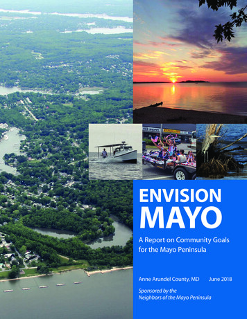
Purpose & StructureThe Envision Mayo project was launched by avolunteer group, the Neighbors of the MayoPeninsula, to engage the residents of Mayo,Maryland, in a community conversation about avision for Mayo’s future and how to achieve it.Eighty-five Mayo residents participated in seven meetingsthat took place between September 2017 and April 2018.Major topics of discussion included:1. Health and safety2. Infrastructure/ transportationThe Need for Envision MayoThe Mayo Peninsula in Edgewater, MD, extends fromthe intersection of State Route 214 and Muddy CreekRoad east for approximately 4.2 miles. Route 214, runningnearly the full length of the peninsula, provides soleaccess to its side roads and neighborhoods. The peninsulais bordered by the South River to the north and by theWest and Rhode Rivers to the south; both rivers flowinto the Chesapeake Bay, which wraps the shore of thepeninsula at its eastern edge. The peninsula has a breadthof roughly 1.5 miles at its widest points and 2,000 feet atits most narrow pass. Mayo is home to more than 8,000residents, one elementary school, and several churches,marinas, and parks.3. Parks/natural areas4. Environment5. Growth and development6. Community character/quality of lifeThe meetings were facilitated by Mayo resident Jim Lyonsand supported with donated time by landscape architectBob Snieckus. Guests in attendance at various meetingsincluded members of other nonprofit organizations andcommunities in Anne Arundel County, officials from thecounty office of Planning & Zoning and the PlanningAdvisory Board, county council and state legislaturecandidates, a county executive candidate, and local media.We thank the community for their invaluable participationand our guests for their interest in our community.Like other peninsulas in Anne Arundel County, the MayoPeninsula is defined by its sensitive shoreline environment,confined by limited road access, and confronted withsignificant pressure for development. The communitybecame increasingly engaged with these issues over thepast two years as the county launched plans to significantlyincrease the development of five parks on the peninsulaand to lift an eight-year building moratorium. Thebuilding moratorium, imposed until wastewater treatmentupgrades were complete, ended in November 2017.The community’s greatest concern was the lack of a proactive land use plan to effectively manage the combinedimpact of park and residential developments on traffic,emergency services, groundwater supplies (Mayo is servedentirely by well water), and the environment. The last landuse plan to address the peninsula was the 2002 Edgewater/Mayo Small Area Plan, which was created through a lengthybut detailed and popular public process; however, countyofficials failed to pursue most of its recommendations.1
Mayo Community ConcernsBy the spring of 2017, the Mayo community outlineda range of concerns, discussed by residents andpresented to county officials as follows:Population:Previously, the county had predictedthat Mayo’s population wouldreach 8,727 people by 2035. But thepopulation reached 8,799 in 2015 —twenty years faster than projected.Development:The county predicts at least 630 new“units” will be built on the Mayopeninsula under the current zoning.Mayo’s Small Area Plan hasn’t beenupdated since 2002.Traffic:Parks:The only road onto the peninsula isState Route 214. Backups are frequent.The state has graded the road at E/Ffor “heavy congestion.” At just 2 carsper household, the predicted 630 newhomes could add more than 1,200vehicles to daily traffic. The county hassince conducted a study that will becombined with a pending study on theimpact of residential development, butlifted the building moratorium beforethis study was completed.The county is expanding 5 parks inMayo — with a potential combinationof sports fields, trails, and swimmingbeaches — with a total of approximately1,100 parking spaces (covering 8 acres)and related potential for impact ontraffic, wildlife habitat, and stormwaterrunoff from increased impervioussurface.EMS:Fire and EMS response times are longerthan the nationally recommendedresponse times WITHOUT traffic. Mostroads lack shoulders. When an accidentshuts down State Route 214, emergencyvehicles cannot pass through. Cyclistsand pedestrians are not safe. A pedestrianfatality occurred in 2016. (The countyhas since opened a part-time substationin Mayo on a trial basis, served by oneambulance.)Aquifers:The capacity of the aquifers serving Mayois unclear. Some wells have failed. Mayoresidents requested a study of aquifercapacity to meet growth projectionsin 2002, but none was done. Residentsagain requested a study in 2016 inanticipation of the county’s decision tolift the building moratorium. The countyagreed to conduct a study, with resultsexpected in summer 2018, but buildinghas resumed and is accelerating.Water pollution: Six of the seven major creeks and smallbays on the peninsula are pollutedaccording to federal standards in theClean Water Act. The primary sourceof pollution is stormwater runoff fromroads, parking lots, and deforestationassociated with new construction.The South River is under TMDLs (TotalMaximum Daily Loads) for nutrients,sediment, fecal coliform, and PCBs.Impervious surfaces associated withdevelopment (roof tops, roads, andparking lots) are main sources of waterpollution. A 2016 study by the Universityof Maryland found that Anne ArundelCounty approves 89% of the variancerequests for construction projects onprotected shoreline land known as theCritical Area, but the extent to whichthese variances harm water quality isnot clear.2
Envision Mayo and the 2002 Small Area PlanTThe 2002 Vision for 2030With park and residential development currently underway,the Neighbors of the Mayo Peninsula wanted to gathercommunity input into land-use planning with an organizedprocess for collecting and sharing the community’s concernsand views. Envision Mayo was the result. The county and community manage collaborativeprograms designed to protect and preserve thedelicate balance of life and health of the rivers andcreeks. The only access road to the peninsula — State Route214 — is a tree-lined, pedestrian and bicycle-friendlyroad. (Safe, convenient pedestrian and bicycle access isprovided all along the peninsula.) Improvements to safety on Route 214 includeshoulders, widening of intersections and turn lanes. Communities are well served by emergency and publicsafety services. Development has not been allowed to unduly stressaquifers and cause salt water intrusion. The loss of trees and forested areas has been limited,as well as the fragmentation of large forest tracts. Development practices protect and enhance openspace and forest and minimize impact to sensitiveareas. The Critical Area Law and other wetlands regulationsare adhered to strictly. Stormwater management is improved so thatcumulative impacts of land use changes are fullyaddressed prior to their implementation. A minimum 100-foot forested buffer is preserved orrestored where possible along the edge of rivers andbeside perennial and intermittent streams. Use of parks in the Resource Conservation Areas islimited to passive activities to keep land disturbance toa minimum.he county began work to revise its General DevelopmentPlan in 2017, but will not update the Small Area Plans until atleast 2020, after the General Development Plan is complete.The Envision Mayo report does not replace the SmallArea Plan or eliminate the need for its update. This reportis a summary of community vision and goals, and itprovides a foundation for engaging with county officialsand staff, elected officials, political candidates, and otherorganizations to enact solutions that guide future growthand development on the Mayo Peninsula. It is critical thatwe find innovative and proactive strategies for balancingland use and resource management on this geographicallyconstrained and environmentally sensitive peninsula.The community conversation about Mayo’s future is stillunderway. This report is intended to be the catalyst for moreconversation and participation in the General DevelopmentPlan process and the future Small Area Plan. The feedbackand suggestions presented here send a clear message aboutwhy we value our community, the quality of life we enjoyand would like to protect, and the things we’d like to change.We thank the 85 Mayo residents who gave their time andenthusiasm to this project and hope to hear from many more.Envision Mayo Process Reviewed existing 2002 Small Area Plan. Discussed values we associate with life on the Mayopeninsula. Identified issues/concerns affecting peninsula residentsand quality of life. Discussed impediments to overcoming them andidentified potential solutions. Created “2030” vision of Mayo community and qualityof-life objectives. Described growth and development to overcomeimpediments and achieve 2030 vision/values.Envision Mayo participants reviewed the 2002 Small AreaPlan and found that the community’s vision statement –produced 15 years ago – still apply. Here’s a re-cap:3
Envision Mayo participants helped to expand thisvision for their community in 2030:Mayo is a safe, vibrant, quiet, and connected community. Growth has been managed to respectand emphasize the community’s connection to the water and wildlife, nature, our history andculture, and each other. A system of walking trails and bicycle paths was created to connectresidents and communities to appropriately scaled stores, restaurants, and parks and to provideopportunities for exercise and places to interact. Wildlife habitat and travel corridors connectingwildlife on the peninsula and in surrounding areas have been restored to bring back fish andwildlife in areas where their demise was imminent.A Mayo Community Center provides a place for residents and visitors to meet, attend specialevents, shop at a weekly farmers’ and watermens’ market, and explore displays that highlight thearea’s historical, cultural, and natural resources, including the history of people who have livedand worked on the peninsula and drawn sustenance from its land and waters.The loss of Mayo’s remaining forest was checked and investments were made in restoringdegraded shorelines and disturbed habitats. Headwater areas for the streams flowing into theSouth, West, and Rhode Rivers were preserved. And, through land conservation and restorationefforts and a “no net loss” requirement to mitigate land disturbance activities on the peninsula,water quality in the surrounding waterways is improving.The public enjoys Mayo parks, managed through a cooperative plan that defines the appropriatescale and usage of each park to minimize negative impacts to natural resources and trafficcongestion. Through an innovative partnership with local marinas, private boat ramps weremade available for launching boats on the peninsula at a discounted rate, providing morebusiness for local marinas and limiting additional disturbance to shorelines where aquatic grassesare being planted to improve water quality.Schools serving Mayo consistently accommodate students with no threat of overcrowding.Additional traffic that comes with morning and afternoon rush hours is alleviated byimprovements in the area of its intersection with Loch Haven Drive. Emergency response timeshave improved thanks to a two-bay emergency substation now located on the peninsula, with anambulance and fire truck. A bike lane extends the length of the peninsula (with gas and electriclines buried beneath it) and provides emergency vehicles with passage when needed.5
Concerns & StrategiesAchieving such a vision, or one similar to it, dependson addressing a number of current challenges andcreating a comprehensive, pro-active plan for sustainablegrowth and development. Support and leadership fromcounty officials is critical. Mayo residents have identifiedtheir greatest concerns — and ideas for addressing them— as follows.1. Health and safetya) Emergency response times are longer than therecommended national average.Add a substation on the peninsula for fire and EMS services.Note: a part-time substation for EMS only has been addedon a trial basis off of Loch Haven Road.2. Infrastructure/transportationa) Inadequate road system leading to frequent trafficdelays, congestion, accidents.Supporting infrastructure should be planned in advance ofanticipated development. Seek solutions with communityinput to improve safety and alleviate traffic congestionon the peninsula, especially near the Loch Haven intersection. Make only conservative additions to parkingareas at Mayo parks.b) Frequent power outages due to inadequate maintenanceof overhead lines.Bury future utilities to limit future power losses, preferablyunder a bike lane.b) Concern for adequacy and quality of groundwatersupplies. Wells are failing and contaminants such asarsenic have been identified in select areas.Assure aquifers are adequate to support added development. Ensure that water quality information is updatedand communicated to residents.c) Roadways lack shoulder/safe areas for pedestriansand cyclists.Create a bike lane and/or a connected network of walkingand biking trails. Address cyclist and pedestrian safetyissues along the curve and roadway approaching BeverlyTriton park.d) Frequent road flooding and no plans to deal with sealevel rise.Identify steps to minimize climate impacts on floodedroads, septic systems, shorelines and wells.e) Some homes on the peninsula experience backflows ofsewage into their basement during heavy rains.Upgrade pumps and improve the system to prevent leaksand backflows during heavy rains and floods.6
3. Parks/natural areas4. Environmenta) Expansion of parks will increase traffic and impacts tothe natural resources, in addition to impacts fromexisting sites such as the Carr’s Wharf fishing pier andboat ramp and Glebe Heights dog park.a) Increased impervious surfaces will worsen pollutedstormwater runoff.Plan for a system of parks that complement each other.Carefully plan for park capacity with regard to its fullrange of impacts. Retain natural and targeted environmental areas and each park’s character (e.g., BeverlyTriton as a nature area and Mayo Beach for swimming).Limit development of natural areas at South River FarmPark and Beverly-Triton Park as passive recreation areas.Create a comprehensive environmental restoration andmanagement plan for South River Farm Park and BeverlyTriton park.Enforce the enacted codes and set a goal to create noincrease in runoff from new development (often referredto as “no-net-loss” of stormwater from a site). Improveregulations to require more pervious surfaces wherepossible, including in parks.Develop a comprehensive plan for addressing stormwaterrunoff from all anticipated development, deforestation,and anticipated increases in impervious surfaces on thepeninsula to support the legally mandated role thatAnne Arundel County must play in the regional Bayclean-up effort.b) Development will accelerate loss of forests/wetlandsand may provide inadequate mitigation.Require effective mitigation, to be located on thepeninsula, to offset any forest or wetland loss. Enforcelaws to conserve lands in the Critical Area. Encourageplans that retain forests and wetlands. Investigate optionsfor conservation easements or Transferable DevelopmentRights programs. Avoid development in headwater areasand establish a minimum 100-foot buffer for all streamsthat feed into the South, West and Rhode Rivers andassociated wetlands.c) Maintain existing wetlands, wildlife habitat, andconnectivity with surrounding natural areas. Ensurethat the county submits required reports on resident,threatened, and endangered wildlife in the statedefined Critical Area of the Mayo Peninsula.Encourage plans that retain forests and wetlands, workingwith the Maryland Department of Natural Resources andSmithsonian Environmental Research Center to identifyimportant habitat area and support habitat for speciesthat migrate between Mayo and adjacent Smithsonianland. Investigate options for conservation easements orTransferable Development Rights programs. Protect andrestore highly erodible lands, shorelines, and wetlands onthe peninsula.7
5. Growth and Development6. Community Charactera) Accelerated pace of development is taking placewithout adequate infrastructure in place.a) Create an active community center, preferably using anexisting or historic building.Produce a comprehensive study of the infrastructureneeded to support current and anticipated growth; thestudy should be conducted in full transparency with activeand meaningful public participation.b) Improve communications between neighborhoodassociations.c) Improve Mayo representation on committees and inprocesses at the community, county, and state levels.Use the study results to review and revise impact feesto cover the real impacts to peninsula residents and theenvironment. Set fees to encourage building in preferredlocations and to discourage in sensitive areas.b) Communities lack notification/information tounderstand impacts of new development.Improve the county’s internal information systems andrequire pro-active and timely outreach to communitieswith opportunities for public participation in plans asnew development is proposed. Treat our community asa partner in planning for growth, with the community’svision in mind and not solely the developers’ desires.c) Frequent variances are granted from existing zoningrequirements.The county should develop a transparent processto inform the public of requested variances in theCritical Area in reasonable advance of hearings thatwill determine whether the variances will be granted.Variances in the Critical Area should be avoided and,when granted, should be rare, rather than the rule.d) The existing Adequate Public Facilities Ordinances failto achieve their intended goals, and current buildingcodes fail to account for the environmental fragilityand limited emergency ingress/egress on peninsulas.Enforce the existing APFOs. Revise the APFOs to coverthe full costs of development and revise the APFOs and/or create an overlay in the building code that addressesissues specific to peninsulas.8
Moving ForwardA Visible, Active CommunityThe key to achieving these goals, or others that maybe identified in the future, is meaningful publicparticipation. We must continue asking for plans andpolicies that are shaped in true partnership with peoplethey affect and hold our elected leaders accountable forencouraging this partnership. County departments shouldproactively inform and engage the public in all aspects ofland use development and project planning. We invite thecounty to consider developing a partnership and processfor working with the Mayo community to serve as a pilotproject illustrating how to improve the planning anddevelopment process for all Anne Arundel communities.We should also do our part: research the problems, listento different perspectives, learn from those who’ve workedon these issues in the past, monitor development projectsand their impacts, and share what we learn with others.And, of course, we should continue to speak up — bywriting letters, making phone calls, attending meetingsand doing a better job of communicating with countyleadership, elected officials, and each other. Mayo is agreat community, with lots of talent, energy and ideas.We encourage you to make your views known and totake an active role in helping to shape the future of ourcommunity.About Neighbors of theMayo PeninsulaThe Neighbors of the Mayo Peninsula is a volunteergroup that formed in 2016 to raise awareness and takeaction on issues that impact quality of life on the peninsula.There are lots of ways to be involved.Sign up for the newsletter atwww.NeighborsoftheMayoPeninsula.orgEmail us at NeighborsofMayo@gmail.com.9
The Mayo Peninsula in Edgewater, MD, extends from the intersection of State Route 214 and Muddy Creek Road east for approximately 4.2 miles. Route 214, running nearly the full length of the peninsula, provides sole access to its side roads and neighborhoods. The peninsula is bordered by the South River to the north and by the