Transcription
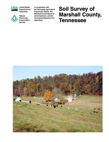
United StatesDepartmentof AgricultureNaturalResourcesConservationServiceIn cooperationwithNew MexicoAgriculturalExperimentStationAndCity of SantaFe, Santa FeCounty,National ParkService, andDepartment ofDefenseSoil Survey ofSanta Fe CountyArea, New Mexico
How To Use This Soil SurveyDetailed Soil MapsThe detailed soil maps can be u seful i n pla nning th e u se and m anagement ofsmall areas.To find information ab out your area of intere st, locate that are a on the Index toMap Sheets. Note the number of the map sheet and turn to that sheet.Locate your area of inte rest on the ma p sheet. Note the map u nit symbols t hatare i n that a rea. Tu rn to t he Contents, which li sts the map units by symbol andname and shows the page where each map unit is described.The Contents sh ows which tabl e ha s data on a specific l and use fo r ea chdetailed soil map u nit. Also see the Conten ts fo r sections of this p ublication thatmay address your specific needs.i
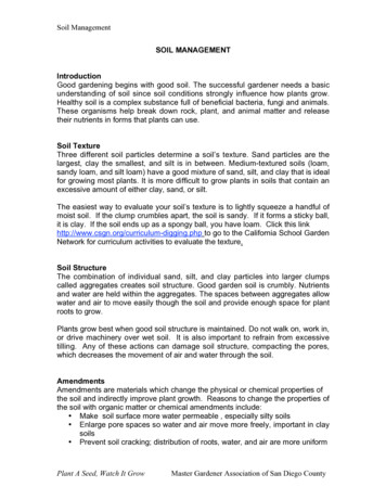
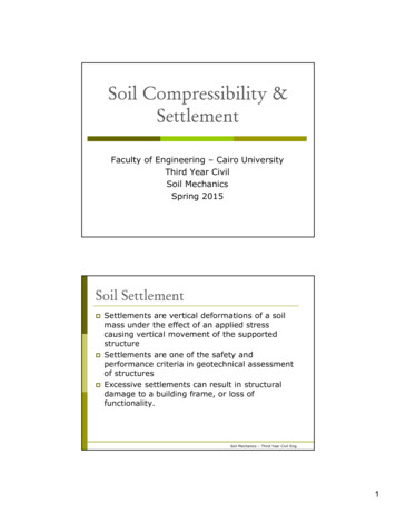
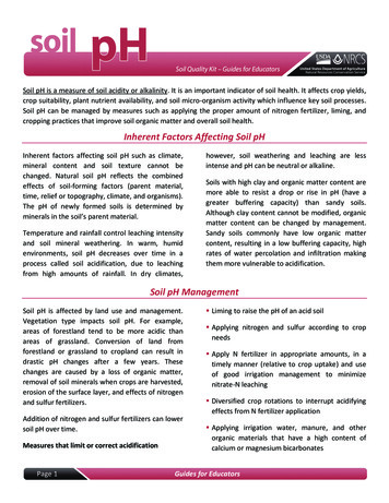
This soil survey is a publication of the National Cooperative Soil Survey, a jointeffort of the United States Department of Agriculture and other Federal agencies,State agencies including the Agricultural Experiment Stations, and local agencies.The Natural Resources Conservation Service has leadership for the Federal part ofthe National Cooperative Soil Survey.Major fieldwork for this soil survey was completed in September, 2005. Unlessotherwise indicated, statements in this publication refer to conditions in the surveyarea in 2004. This survey was made cooperatively by the Natural ResourcesConservation Service, the National Park Service, and the New Mexico AgriculturalExperiment Station.Only climate tables are included in this survey. Since publication of the soilsurvey, more data on soil properties may have been collected, new interpretationsdeveloped, or existing interpretive criteria modified. Current data tables can beaccess through the Web Soil Survey at http://websoilsurvey.nrcs.usda.gov.Soil maps in this survey may be copied without permission. Enlargement ofthese maps, however, could cause misunderstanding of the detail of mapping. Ifenlarged, maps do not show the small areas of contrasting soils that could have beenshown at a larger scale.The U.S. Department of Agriculture (USDA) prohibits discrimination in all itsprograms and activities on the basis of race, color, national origin, age, disability, andwhere applicable, sex, marital status, familial status, parental status, religion, sexualorientation, genetic information, political beliefs, reprisal, or because all or a part ofan individual’s income is derived from any public assistance program. (Not allprohibited bases apply to all programs.) Persons with disabilities who requirealternative means for communication of program information (Braille, large print,audiotape, etc.) should contact USDA’s TARGET Center at (202) 720-2600 (voiceand TDD). To file a complaint of discrimination write to USDA, Director, Office of CivilRights, 1400 Independence Avenue, S.W., Washington, D.C. 20250-9410, or call(800) 795-3272 (voice) or (202) 720-6382 (TDD). USDA is an equal opportunityprovider and employer.Cover: Typical area of map unit 208—Alire-Urban land complex, 2 to 8 percent slopes. The homesin this area are all Santa Fe or Southwest style architecture, typified by flat roofs, earth tonestucco walls, and viega ceilings. The Sangre de Cristo Mountains are in the background,toward the left is Santa Fe Baldy, which at 12,622 feet elevation, is the highest peak in Santa FeCounty.Additional information about the Nation’s natural resources is available on theNatural Resources Conservation Service homepage on the World Wide Web. Theaddress is http://www.nrcs.usda.govii
ContentsHow To Use This Soil Survey .iForeword . xiGeneral Nature of the Survey Area .2History and Development.3Physiography, Geology, and Geomorphology .4Climate .5Climate Data .6Table 1.—Temperature and Precipitation.7Table 2.—Freeze Date in Spring and Fall .8Table 3.—Growing Season .8Table 4.—Temperature and Precipitation.10Table 5.—Freeze Date in Spring and Fall .11Table 6.—Growing Season .11Table 7.—Temperature and Precipitation.13Table 8.—Freeze Date in Spring and Fall .14Table 9.—Growing Season .14How this Survey Was Made.15Detailed Soil Map Units.19100—Panky loam, 1 to 4 percent slopes.20101—Zozobra-Jaconita complex, 5 to 25 percent slopes .22102—Khapo sandy loam, 3 to 8 percent slopes.24103—Zepol silt loam, 0 to 2 percent slopes, flooded.26104—Chupe-Riverwash complex, 1 to 3 percent slopes, flooded.28105—Dumps, sanitary landfill .30106—Pits .31107—Riverwash, flooded.32108—Zia fine sandy loam, 0 to 2 percent slopes .33109—Tetilla loam, 1 to 5 percent slopes .35110—Calabasas loam, 1 to 3 percent slopes.37111—Khapo fine sandy loam, 1 to 3 percent slopes .39112—Riovista gravelly loamy sand, 0 to 1 percent slopes.40113—Delvalle-Urban land complex, 0 to 2 percent slopes .42114—Devargas-Urban land complex, 1 to 3 percent slopes.44115—Panky-Urban land complex, 1 to 4 percent slopes .46116—Arents-Urban land-Orthents complex, 1 to 60 percent slopes.48117—Agua Fria-Paraje complex, 1 to 8 percent slopes .50118—Golondrina-Paraje complex, 8 to 45 percent slopes .53119—Vitrina-Haozous complex, 5 to 15 percent slopes, flooded.56120—Quarteles-Rock outcrop complex, 25 to 90 percent slopes .58121—El Rancho silt loam, 1 to 3 percent slopes.60122—Cuyamungue-Riverwash complex, 0 to 2 percent slopes, flooded.62123—Koshare very fine sandy loam, 2 to 8 percent slopes .65124—Camelrock silty clay loam, 0 to 2 percent slopes .67125—Mirada-Bosquecito complex, 0 to 2 percent slopes, flooded .69126—Walkibout-Innacutt complex, 2 to 80 percent slopes, flooded .72127—Ojito-Koshare-Quarteles complex, 5 to 50 percent slopes .75iii
Detailed Soil Map Units. Cont.128—Koshare-Urban land complex, 2 to 8 percent slopes.78129—El Rancho-Urban land complex, 1 to 3 percent slopes.80130—Jaralosa very fine sandy loam, 0 to 2 percent slopes, flooded .82131—Jaconita-Xenmack complex, 25 to 60 percent slopes .84132—Depolvo-Sueleros complex, 2 to 15 percent slopes .86133—Chupe fine sandy loam, 1 to 3 percent slopes.89134—Bosquecito fine sandy loam, 0 to 2 percent slopes, flooded.91135—Tsinat gravelly loam, 1 to 6 percent slopes.93136—Churipa very cobbly sandy loam, 5 to 15 percent slopes .95137—Medrano extremely gravelly loam, 5 to 65 percent slopes .97138—Andanada very gravelly loam, 5 to 15 percent slopes .99139—Ildefonso-Rock outcrop-Rubble land complex, 30 to 70percent slopes.101140—Truehill very cobbly loam, 25 to 45 percent slopes.103141—Truehill-Penistaja family-Rock outcrop complex, 4 to 50percent slopes.105142—Parida gravelly loam, 3 to 10 percent slopes .107143—Scogg very fine sandy loam, 0 to 2 percent slopes, flooded .108144—Los Alamos fine sandy loam, 1 to 5 percent slopes .109145—Romberg very gravelly sandy loam, 25 to 55 percent slopes .111200—Predawn loam, 1 to 4 percent slopes.112201—Tanoan-Encantado complex, 5 to 25 percent slopes .114202—Alire loam, 2 to 6 percent slopes.117203—Buckhorse-Altazano complex, 2 to 8 percent slopes, flooded .119204—Altazano loamy sand, 0 to 2 percent slopes, flooded .121205—Nazario gravelly loam, 2 to 8 percent slopes .123206—Encantado very cobbly sandy loam, 25 to 45 percent slopes.125207—Urban land.127208—Alire-Urban land complex, 2 to 8 percent slopes .128209—Dondiego-Urban land complex, 1 to 3 percent slopes.130210—Urban land-Buckhorse-Altazano complex, 2 to 8 percent slopes .132211—Tanoan-Encantado-Urban land complex, 5 to 25 percent slopes.134212—Junebee gravelly sandy loam, 5 to 15 percent slopes.137213—Levante-Riverwash complex, 1 to 3 percent slopes, flooded .139214—Nazario-Urban land complex, 2 to 8 percent slopes .141215—Predawn-Urban land complex, 1 to 4 percent slopes .143216—Dondiego loam, 1 to 3 percent slopes .145217—Ohke sandy loam, 1 to 3 percent slopes.146218—Pedregal very gravelly loam, 2 to 15 percent slopes .147219—Ohke sandy loam, 2 to 8 percent slopes.149220—Horcado-Nazario complex, 2 to 35 percent slopes .150221—Latierra-Lamesilla-Levante complex, 2 to 15 percentslopes, flooded .152222—Sipapu-Yuzarra-Kachina complex, 5 to 65 percent slopes.155223—Kachina fine sandy loam, 5 to 15 percent slopes .158224—Portillo extremely gravelly sandy loam, 25 to 50 percent slopes .160225—Encantado-Resolana complex, 35 to 70 percent slopes .162226—Crucitas gravelly fine sandy loam, 2 to 10 percent slopes.164300—Arnor gravelly sandy loam, 2 to 8 percent slopes .166301—Enmedio-Atalaya-Rock outcrop complex, 5 to 60 percent slopes .168302—Setonville-Antonchico complex, 3 to 15 percent slopes .170303—Morenda, Fiesta, and Espanola soils, 1 to 85 percentslopes, flooded .172iv
Detailed Soil Map Units. Cont.304—Legate-Yohalem-Zarmand complex, 5 to 50 percent slopes .176305—Chimayo-Rock outcrop-Quapaw complex, 50 to 90percent slopes.179306—Adellern gravelly sandy loam, 50 to 90 percent slopes .181307—Urban land-Ustorthents-Ustarents complex, 1 to 65percent slopes.183308—Enmedio-Zafarano-Rock outcrop complex, 35 to 60percent slopes.185309—Lazaro complex, 5 to 45 percent slopes .187310—Santa Fe-Rock outcrop complex, 25 to 45 percent slopes .189400—Chiminet-Canuela-Rock outcrop complex, 2 to 20 percent slopes.191401—Rock outcrop-Abrojo-Chiminet complex, 25 to 65 percent slopes.195402—Navajita complex, 2 to 15 percent slopes .198403—Piojillo paragravelly ashy loamy coarse sand, 3 to 15percent slopes.200404—Totavi ashy loamy coarse sand, 1 to 3 percent slopes.201405—Espiritu-Pedregal complex, 3 to 50 percent slopes.203406—Rock outcrop-Zacaton-Chiminet complex, 25 to 60percent slopes.206407—Rock outcrop-Chiminet complex, 20 to 50 percent slopes .209408—Adornado very paragravelly ashy coarse sandy loam, 8 to 15percent slopes.211409—Hackroy-Nyjack complex, 2 to 12 percent slopes .213410—Chiminet-Canuela-Rock outcrop complex, low precipitation,3 to 20 percent slopes.216412—Canuela-Hackroy complex, 1 to 8 percent slopes .220413—Armenta very paragravelly ashy coarse sand, 3 to 20percent slopes.222414—Metate loam, 0 to 3 percent slopes.224500—Sedillo very gravelly loam, 2 to 6 percent slopes.226501—Truehill extremely gravelly loam, 25 to 55 percent slopes.229502—Khapo fine sandy loam, 1 to 3 percent slopes .231503—Espinos very gravelly coarse sandy loam, 5 to 40 percent slopes .232504—Sandoval-Badland complex, 15 to 45 percent slopes.233505—Puertecito-Paraje complex, 15 to 50 percent slopes .236506—Ildefonso-Sandoval complex, 5 to 35 percent slopes .239507—Ildefonso extremely gravelly sandy loam, 5 to 15 percent slopes .241508—Charalito-Riverwash complex, 1 to 3 percent slopes, flooded.242509—Puertecito-Wandurn-Rock outcrop complex, 30 to 60percent slopes.244510—Cerrillos-Sedillo complex, 1 to 5 percent slopes .247511—Wandurn-Alchonzo-Rubble land complex, 35 to 90percent slopes.250512—Cochiti extremely cobbly loam, 15 to 35 percent slopes.252513—Pedregal very cobbly loam, 8 to 15 percent slopes .254514—Pegasus extremely cobbly loam, 20 to 50 percent slopes.256515—Pastorius very cobbly loam, 3 to 5 percent slopes.257516—Cerrillos fine sandy loam, 1 to 4 percent slopes .258517—Puertecito extremely gravelly fine sandy loam, 15 to 25percent slopes.260518—Rock outcrop-Skyvillage complex, 5 to 35 percent slopes .261519—Cumacho fine sandy loam, 2 to 8 percent slopes .263520—Cielito-Netoma-Tanbark complex, 1 to 25 percent slopes.266v
Detailed Soil Map Units. Cont.521—Devargas-Riovista-Riverwash complex, 0 to 5 percentslopes, flooded .270522—Penistaja family fine sandy loam, 1 to 3 percent slopes .273523—Kech-Cerropelon-Rock outcrop complex, 5 to 50percent slopes.274524—Zia-Gullied land complex, 2 to 10 percent slopes .276525—Hagerman-Cabreros complex, 2 to 6 percent slopes .278526—Penistaja family-Truehill complex, 3 to 15 percent slopes.280527—Musofare-Asparas complex, 20 to 50 percent slopes.283528—Penistaja family loam, 3 to 8 percent slopes.285530—Jaralosa-Chupe-Riverwash complex, 0 to 1 percentslopes, flooded .286531—Sena very fine sandy loam, 0 to 2 percent slopes .289532—Galiseto silty clay loam, 0 to 2 percent slopes .291534—Oelop-Charalito complex, 1 to 3 percent slopes .292550—Pits, mine.294600—Hyer-Witt complex, 1 to 3 percent slopes .295601—Harvey loam, 3 to 12 percent slopes .297602—Palma fine sandy loam, 3 to 8 percent slopes .298603—Lazarus silt loam, 0 to 2 percent slopes, flooded.299604—Desario-Espadon complex, 5 to 50 percent slopes .300605—Lazarus-Manzano complex, 0 to 8 percent slopes, flooded .303606—Pastura-Nala complex, 3 to 15 percent slopes .305607—Davishat-Palma complex, 1 to 8 percent slopes.308608—Davishat loamy very fine sand, 3 to 8 percent slopes .310610—Arojomil-Tapia complex, 1 to 5 percent slopes .311611—Spyglass silt loam, 0 to 2 percent slopes.313612—Trofes loam, 0 to 2 percent slopes.315613—Kinsell silt loam, 0 to 2 percent slopes, flooded .317614—Tamarindo loam, 1 to 3 percent slopes.319615—Kwahe-Stanley complex, 0 to 1 percent slopes, ponded.320616—Triane silty clay loam, 1 to 3 percent slopes .322617—Ranchos fine sandy loam, 3 to 8 percent slopes .323618—Davishat-Chupadera complex, 3 to 8 percent slopes .324619—Villario-Puertecito complex, 25 to 45 percent slopes .326621—Kech-Horchata complex, 1 to 8 percent slopes .328622—Arojomil silt loam, 1 to 3 percent slopes .330623—Clovis loam, 3 to 8 percent slopes .332624—Clovis very fine sandy loam, 1 to 3 percent slopes.333625—Raydawn very cobbly sandy loam, 15 to 35 percent slopes.334626—Horchata loam, 3 to 8 percent slopes .335627—Palabria-Frajillo complex, 1 to 8 percent slopes .336628—Nala gravelly sandy loam, 3 to 8 percent slopes .338629—Frajillo-Chilerojo complex, 5 to 15 percent slopes .340630—Tamarindo loam, 3 to 8 percent slopes.342632—Travessilla-Raydawn-Sandoval-Rock outcrop complex, 5 to 45percent slopes.343700—Aliante-Altega complex, 1 to 10 percent slopes.346701—Sabroso-Verano complex, 35 to 65 percent slopes .349702—Estrada-Chacuaco complex, 2 to 8 percent slopes .351703—Estrada loam, 2 to 15 percent slopes .354704—Aliante loam, 0 to 3 percent slopes.356705—Margosa-Condesa complex, 2 to 8 percent slopes.357vi
Detailed Soil Map Units. Cont.706—Verano-Altezita complex, 45 to 90 percent slopes.359707—Altezita-Esquila-Rock outcrop complex, 2 to 10 percent slopes.363708—Uva-Herrada complex, 3 to 15 percent slopes.365709—Moriartche clay loam, 0 to 3 percent slopes .367710—Predawn fine sandy loam, 1 to 4 percent slopes .368711—Fangio-Ortiz complex, 15 to 50 percent slopes .370712—Altega very fine sandy loam, 3 to 8 percent slopes .375713—Lomapedro-Skyute complex, 2 to 10 percent slopes.377715—Lomapedro gravelly sandy clay loam, 25 to 50 percent slopes .380717—Glorieta-Ribera complex, 1 to 15 percent slopes.382718—Bernal-Cueva complex, 10 to 50 percent slopes .385W—Water .388Use and Management of the Soils .389Rangeland.389Forest Management.390Classification of the Soils.391Soil Series.392Abrojo Series.392Adellern Series.392Adomado Series.392Agua Fria Series .392Alchonzo Series .392Aliante Series .392Alire Series.392Altazano Series .392Altega Series.392Altezita Series .392Andanada Series.392Antonchico Series .392Armenta Series .392Arnor Series .392Arojomil Series .392Asparas Taxadjunct .392Atalaya Series .392Bernal Series.392Bosquecito Series .392Buckhorse Series .392Cabreros Series .392Camelrock Series.392Canuela Series.392Cerrillos Series.392Cerropelon Series .392Chacuaco Series.392Charalito Series.392Chilerojo Series.392Chimayo Series.392Chiminet Series.392Chupadera Series .392Chupe Series .392Churipa Series .392Cielito Series .392Clovis Series .392Cochiti Series .392vii
Soil Series. Cont.Condesa Series.392Crucitas Series.392Cueva Series.392Cumacho Series.392Cuyamungue Series.392Davishat Series .392Delvalle Series .392Depolvo Series.392Desario Series.392Devargas Series.392Dondiego Series.392El Rancho Series .392Encantado Series.392Enmedio Series.392Espanola Series .392Espinos Series .392Esquila Series .392Estrada Series.392Fangio Series .392Fiesta Series .392Frajillo Series .392Glorieta Series .392Golondrina Series .392Hagerman Series .392Haozous Series.393Harvey Series.393Herrada Series .
in this area are all Santa Fe or Southwest style architecture, typified by flat roofs, earth tone stucco walls, and viega ceilings. The Sangre de Cristo Mountains are in the background, toward the left is Santa Fe Baldy, which at 12,622 feet elevation, is the highest peak in Santa Fe County.