Transcription
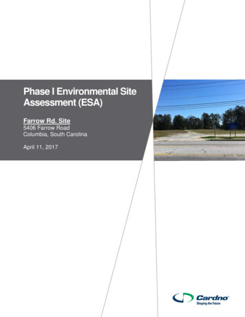
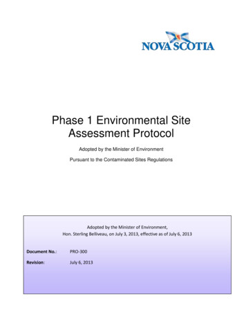
August 10, 2015Ms. Lynn DittmerMetropolitan Area Planning Agency2222 Cuming StreetOmaha, NE 68102Re:South Omaha Brownfields Coalition Assessment GrantPhase I ESA Update ReportMichael Henery Parcel2625 Deer Park Blvd., Omaha, NEAttention Ms. Dittmer:The purpose of this letter is to provide a Phase I Environmental Site Assessment (ESA) Update of theMichael Henery Parcel located at 2625 Deer Park Boulevard in Omaha, Douglas County, Nebraska (the“Property”) with respect to any changes since the original Phase I ESA report was prepared for theProperty in November 2012 that would require amendments to the conclusions of the 2012 report. Figure1 (Site Location Map) and Figure 2 (Site Diagram) show the location of the Property.This Phase I ESA Update is being prepared for Mr. Michael Henery and the Omaha Brownfields Coalitionand was conducted as part of the South Omaha Brownfields Coalition Assessment Grant beingadministered by Metro Area Planning Agency (MAPA). A Phase I ESA was previously prepared for this sitein November 2012 by Alfred Benesch & Company (Benesch) in general conformance with the scope andlimitations of ASTM Standard Practice E 1527-05 (ASTM E1527-05), which revealed evidence of recognizedenvironmental conditions (RECs) in connection with the Property in regards to the Omaha Lead Site andthe construction date of the Property (potential lead based paint).Scope of WorkThe scope of work for this Phase I ESA Update included a review of the original Phase I ESA, a site visit,owner interview, and a regulatory records review. This scope does not include sampling of air, soil, groundor surface water, or building materials.The ASTM standard was revised in 2013 (ASTM E1527-13). Significant changes to the standard were madeand are discussed in this report. The changes to the standard were considered during preparation of thisPhase I ESA Update and are addressed in this report.Review of Previous Phase I ESA ReportBenesch reviewed the following report prepared by Benesch in November 2012:
Phase I Environmental Site Assessment, Michael Henery Parcel, 2625 Deer Park Boulevard,Omaha, Douglas County, Nebraska prepared by Benesch for Mr. Michael Henery and the OmahaBrownfields Coalition, dated November 2012 (2012 ESA Report).The 2012 ESA Report consisted of a review of regulatory and historical records (Environmental DataResources {EDR} report), interviews with the Property owner and occupant and/or local agencies, and asite visit to assess the interior and exterior of the building and surrounding properties. Benesch concludedin the 2012 ESA Report that there was evidence of RECs in connection with the Property and made thefollowing recommendations: Based on the construction date of the Property building (1958), Benesch recommends samplingfor lead based paint (LBP) prior to redevelopment or demolition of the existing structure. Although the Omaha Lead Site (OLS) source areas have been abated, the impact of the OLS on theProperty itself is unknown at this time, and may still be significant with regard to either potentialcontamination or environmental liability. As such the OLS represents a recognized environmentalcondition for the Property. Therefore, Benesch recommends sampling of site soils for leadcontamination to determine what level of control (if any) may be appropriate for the Property.The 2012 ESA Report did not identify any other RECs in connection with the Property, and no additionalrecommendations were made.Based on the review of the 2012 ESA Report, it is Benesch’s opinion that these RECs are still valid and donot need to be updated for this Phase I ESA Update.Site Visit and InterviewsMr. Brian Fettin of Benesch conducted a site visit on July 27, 2015. Mr. Fettin was accompanied by theProperty owner, Mr. Michael Henery. There were no conditions limiting observation of the Property (e.g.access issues, physical barriers, or weather). However, the fenced cellular tower, which is leased out byMr. Henery and located adjacent north of the Property building, was not accessed. Based on observationsmade during the site visit, the land use for the Property and the surrounding properties appeared to besimilar to those described in the 2012 Phase I ESA Report. However, the Property building was observedto be empty. According to Mr. Henery, his tenant (Americana Companies) had recently moved out. Mr.Henery stated that nothing else has changed regarding the Property since the 2012 ESA Report wasprepared. Site photographs are included as an attachment to this report.Based on observations made during the site visit, the following observations should be updated for thisPhase I ESA Update: The building was observed to be vacant. The 2012 Phase I ESA Report indicated that the buildingwas occupied by Americana Companies, a company that specializes in servicing shopping carts.The 2012 Phase I ESA Report indicated that an air compressor and numerous 55-gallon drumswere observed during the site visit. Nine of the drums were empty, while two contained watersoluble paint. Neither of these items were considered a REC for the Property; however, it should2
be noted that the air compressor or drums were not observed during the site visit for this PhaseI ESA Update.Regulatory Records ReviewThe regulatory agency database report, provided by Environmental Data Resources, Inc. (EDR) of Milford,Connecticut, was reviewed for changes regarding reported releases of hazardous substances andpetroleum products on or near the Property since the 2012 Phase I ESA Report. Review of the 2015 EDRRadius Map Report indicated no new information regarding releases or spills on or near the Property;however, the following information was obtained from the EDR report regarding the Property and shouldbe updated for this Phase I ESA Update: The Property (AT&T Mobility cellular tower) is now listed in the NE AIRS (Nebraska Departmentof Environmental Quality {NDEQ}) and FINDS databases. The AT&T Mobility facility is listed in theNDEQ NE AIRS database due to the presence of the emergency generator on-site and the airemissions from the generator. The FINDS database is a record keeping database. It is Benesch’sopinion that the AT&T Mobility facility still does not represent a REC for the Property.The 2015 EDR Radius Map Report is included as an attachment to this report.The EPA Enviromapper website http://www.epa.gov/emefdata/em4ef.home was accessed forinformation regarding the location of potential hazardous materials and petroleum products sites andsurface spills on or near the Property. No facilities were identified on or near the Property.ASTM E1527-13 RequirementsThe new ASTM E1527-13 has been released since the 2012 ESA Report was prepared. The changes to thestandard include the following items/requirements: That the potential for vapor migration be considered and identified as a REC if applicable. Basedon review of the 2012 ESA Report, the 2015 EDR Radius Map Report, information from NDEQ andthe Enviromapper website, the potential for vapor migration from adjacent or nearby sites is notconsidered a concern in connection with the Property. In addition, given the site conditions (e.g.no basement, slab on grade construction), any potential vapor migration would be unlikely tosignificantly impact the Property.Review of regulatory files for the target property or adjacent parcels if identified during the reviewof regulatory databases. The Property was not listed in the 2012 EDR Radius Map Report.However; the Property was listed in the 2015 EDR Radius Map Report under the FINDS and NEAIRS databases. As discussed previously, these listings were in relation to the AT&T Mobilitycellular tower located on the Property. Based on review of NDEQ documents this listing is due tothe presence of an emergency generator on-site and the potential air emissions from thegenerator and associated construction permit. This listing is not due to a release to theenvironment. The listing of the AT&T Mobility facility in the NE AIRS database does not representa REC for the Property. The NDEQ file documents are included as an attachment to this report.The categorization of RECs to include historical RECs (HRECs) and controlled RECs (CRECs). TheRECs listed in the 2012 ESA Report are not considered HRECs or CRECs, which both apply to sites3
with past releases that have been addressed. There have been no release on the Property whichhave been addressed; therefore, an update to the RECs for the Property are not required for thisPhase I ESA Update.User RelianceThis report was prepared by Benesch at the request of and for the sole benefit and use of the “User”;Michael Henery and the Omaha Brownfields Coalition (lead coalition partner Metropolitan Area PlanningAgency [MAPA]), subject to the limitations described in the report and in the contracting agreementbetween Benesch and the Omaha Brownfields Coalition.Benesch acknowledges that this report will become a matter of public record and copies of this report willbe available for review and reproduction through the MAPA website and/or the Freedom of InformationAct (FOIA). Nevertheless, this report is intended for the exclusive use and reliance of the User in assessingenvironmental issues associated with the Property, and any use or reliance of this report by other partiesis prohibited without the express written consent of the User and Benesch.This report is complete only as an entire document and no section is intended to be used separately. Anyunauthorized use a third party makes of this report, or any reliance on or decision made on the basis ofit, is the responsibility of such third party. The User and Benesch are indemnified against any liabilityresulting from such third party use, reliance or decisions.ConclusionsBased on review of the 2012 ESA Report, interviews, review of regulatory data, and a site visit, in additionto the requirements of ASTM E1527-13, Benesch has determined that updates to the report are necessary,which have been described in the appropriate sections of this Phase I ESA Update. However, the RECsidentified in the 2012 ESA Report are still valid and do not need to be updated. In addition, no additionalRECs were identified. As such, no further assessment of this site is recommended.If you have any questions regarding the conclusions of this assessment, please do not hesitate to contacteither of the undersigned at (402) 333-5792.Respectfully Submitted,Brian FettinProject ScientistChin Lim, P.E.Project Manager4
Attachments:FiguresSite PhotographsRegulatory Database Search (EDR Report)NDEQ RecordsSources (not provided as an attachment; previously submitted or referenced in report):ASTM International, ASTM Standard E1527-13, Standard Practice for Environmental Site Assessments:Phase I Environmental Site Assessment Process.Benesch, Phase I ESA, Michael Henery Parcel, 2625 Deer Park Boulevard, Omaha, NE, November 0138.00\ESA Reports\2625 Deer Park Blvd\Update 20155
FIGURES6
PROPERTYUSGS Topographic ImageryS I T E L O C AT I O N M A P - F I G U R E - 1µ01,0002,0004,000FeetY:\omaha\120100S\MAPA Coalition Grant\00120138.00\ESAs\2625 Deer Park Blvd\GIS\Figure-01.mxdMich a e l H e n e r y P a rc e l E SA26 2 5 D e e r Pa r k Bo u le va r dO ma h a , D o u g la s Co u n ty, N ET. 1 5N , R . 1 3 E , S . 3 3
PROPERTYAND ERS ON/SCO ULA RHAW KIN S CON STR UCT IONVinton StreetOMAHA POLICESOUTHEAST PR EC INCTILROACELL TOWERS 25th Stree tD CORRIDORDeer Par k BoulevardRABEMIS WAREHOUSEHWY75LegendApproximate Property BoundaryProperty structureUSGS Topographic Imagery0100µ200SITE DIAGRAM - FIGURE 2400FeetY:\omaha\120100S\MAPA Coalition Grant\00120138.00\ESAs\2625 Deer Park Blvd\GIS\Figure-02.mxdMich a e l H e n e r y P a rc e l E SA26 2 5 D e e r Pa r k Bo u le va r dO ma h a , D o u g la s Co u n ty, N ET. 1 5N , R . 1 3 E , S . 2 8
SITE PHOTOGRAPHS7
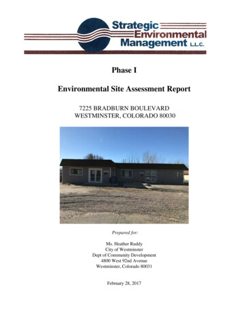
Phase I ESA UpdateMichael Henery Parcel2625 Deer Park BoulevardOmaha, Douglas County, NebraskaBenesch Project No. 00120137.00Site Reconnaissance July 27, 2015PHOTO LOGView southwest from Vinton Street toward the Property located at 2625 Deer Park Boulevard.Closer view toward Property building currently occupied by Americana Companies.1
Phase I ESA UpdateMichael Henery Parcel2625 Deer Park BoulevardOmaha, Douglas County, NebraskaBenesch Project No. 00120137.00Site Reconnaissance July 27, 2015PHOTO LOGView north along east Property line.View west along south Property line.2
Phase I ESA UpdateMichael Henery Parcel2625 Deer Park BoulevardOmaha, Douglas County, NebraskaBenesch Project No. 00120137.00Site Reconnaissance July 27, 2015PHOTO LOGView south of building and lot east of the AT&T facility.View southeast across Property.3
Phase I ESA UpdateMichael Henery Parcel2625 Deer Park BoulevardOmaha, Douglas County, NebraskaBenesch Project No. 00120137.00Site Reconnaissance July 27, 2015PHOTO LOGView northeast from building across parking lot towards main entrance.View along west side of building and propane tank.4
Phase I ESA UpdateMichael Henery Parcel2625 Deer Park BoulevardOmaha, Douglas County, NebraskaBenesch Project No. 00120137.00Site Reconnaissance July 27, 2015PHOTO LOGView east toward Bemis warehouse facility located south of and adjoining the Property.Bemis steel building and drainage way located southwest of the Property.5
Phase I ESA UpdateMichael Henery Parcel2625 Deer Park BoulevardOmaha, Douglas County, NebraskaBenesch Project No. 00120137.00Site Reconnaissance July 27, 2015PHOTO LOGView west along cell tower access road next to fence and city right-of-way landlocated between the chain link fence (northern Property boundary) and Vinton Street.View north toward back lot of River City Barricade facility located east of and adjoining the Property.6
Phase I ESA UpdateMichael Henery Parcel2625 Deer Park BoulevardOmaha, Douglas County, NebraskaBenesch Project No. 00120137.00Site Reconnaissance July 27, 2015PHOTO LOGView west across Property towards AT&T facility.AT&T emergency generator with propane AST located near northwest corner of Property building.7
Phase I ESA UpdateMichael Henery Parcel2625 Deer Park BoulevardOmaha, Douglas County, NebraskaBenesch Project No. 00120137.00Site Reconnaissance July 27, 2015PHOTO LOGView into warehouse from east overhead entrance.View into warehouse from north overhead entrance.8
Phase I ESA UpdateMichael Henery Parcel2625 Deer Park BoulevardOmaha, Douglas County, NebraskaBenesch Project No. 00120137.00Site Reconnaissance July 27, 2015PHOTO LOGView of vacant warehouse area.Floor drain located near east entrance to warehouse.9
Phase I ESA UpdateMichael Henery Parcel2625 Deer Park BoulevardOmaha, Douglas County, NebraskaBenesch Project No. 00120137.00Site Reconnaissance July 27, 2015PHOTO LOGFloor drain located in center of warehouse floor.Floor drain located in the bathroom.10
Phase I ESA UpdateMichael Henery Parcel2625 Deer Park BoulevardOmaha, Douglas County, NebraskaBenesch Project No. 00120137.00Site Reconnaissance July 27, 2015PHOTO LOGGeneral view of office space in southeast corner of building.General view of office space in southeast corner of building.11
REGULATORY DATABASE SEARCH (EDR REPORT)8
Michael Henery Parcel ESA2625 Deer Park Blvd.Omaha, NE 68105Inquiry Number: 04366805.2rJuly 28, 2015The EDR Radius Map Report6 Armstrong Road, 4th floorShelton, CT 06484Toll Free: 800.352.0050www.edrnet.comFORM-LBF-CHZ
TABLE OF CONTENTSSECTIONPAGEExecutive SummaryES1Overview Map2Detail Map3Map Findings Summary4Map Findings8Orphan Summary113Government Records Searched/Data Currency TrackingGR-1GEOCHECK ADDENDUMGeoCheck - Not RequestedThank you for your business.Please contact EDR at 1-800-352-0050with any questions or comments.Disclaimer - Copyright and Trademark NoticeThis Report contains certain information obtained from a variety of public and other sources reasonably available to Environmental DataResources, Inc. It cannot be concluded from this Report that coverage information for the target and surrounding properties does not exist fromother sources. NO WARRANTY EXPRESSED OR IMPLIED, IS MADE WHATSOEVER IN CONNECTION WITH THIS REPORT. ENVIRONMENTALDATA RESOURCES, INC. SPECIFICALLY DISCLAIMS THE MAKING OF ANY SUCH WARRANTIES, INCLUDING WITHOUT LIMITATION,MERCHANTABILITY OR FITNESS FOR A PARTICULAR USE OR PURPOSE. ALL RISK IS ASSUMED BY THE USER. IN NO EVENT SHALLENVIRONMENTAL DATA RESOURCES, INC. BE LIABLE TO ANYONE, WHETHER ARISING OUT OF ERRORS OR OMISSIONS, NEGLIGENCE,ACCIDENT OR ANY OTHER CAUSE, FOR ANY LOSS OF DAMAGE, INCLUDING, WITHOUT LIMITATION, SPECIAL, INCIDENTAL,CONSEQUENTIAL, OR EXEMPLARY DAMAGES. ANY LIABILITY ON THE PART OF ENVIRONMENTAL DATA RESOURCES, INC. IS STRICTLYLIMITED TO A REFUND OF THE AMOUNT PAID FOR THIS REPORT. Purchaser accepts this Report "AS IS". Any analyses, estimates, ratings,environmental risk levels or risk codes provided in this Report are provided for illustrative purposes only, and are not intended to provide, norshould they be interpreted as providing any facts regarding, or prediction or forecast of, any environmental risk for any property. Only a Phase IEnvironmental Site Assessment performed by an environmental professional can provide information regarding the environmental risk for anyproperty. Additionally, the information provided in this Report is not to be construed as legal advice.Copyright 2015 by Environmental Data Resources, Inc. All rights reserved. Reproduction in any media or format, in wholeor in part, of any report or map of Environmental Data Resources, Inc., or its affiliates, is prohibited without prior written permission.EDR and its logos (including Sanborn and Sanborn Map) are trademarks of Environmental Data Resources, Inc. or its affiliates. All othertrademarks used herein are the property of their respective owners.TC04366805.2r Page 1
EXECUTIVE SUMMARYA search of available environmental records was conducted by Environmental Data Resources, Inc (EDR).The report was designed to assist parties seeking to meet the search requirements of EPA’s Standardsand Practices for All Appropriate Inquiries (40 CFR Part 312), the ASTM Standard Practice forEnvironmental Site Assessments (E 1527-13) or custom requirements developed for the evaluation ofenvironmental risk associated with a parcel of real estate.TARGET PROPERTY INFORMATIONADDRESS2625 DEER PARK BLVD.OMAHA, NE 68105COORDINATESLatitude (North):Longitude (West):Universal Tranverse Mercator:UTM X (Meters):UTM Y (Meters):Elevation:41.2290000 - 41 13’ 44.40’’95.9513000 - 95 57’ 4.68’’Zone 15252631.04568167.51188 ft. above sea levelUSGS TOPOGRAPHIC MAP ASSOCIATED WITH TARGET PROPERTYTarget Property Map:Version Date:6713756 OMAHA SOUTH, NE2014AERIAL PHOTOGRAPHY IN THIS REPORTPortions of Photo from:Source:20120626, 20110825USDATC04366805.2r EXECUTIVE SUMMARY 1
MAPPED SITES SUMMARYTarget Property Address:2625 DEER PARK BLVD.OMAHA, NE 68105Click on Map ID to see full detail.MAPIDSITE NAMEADDRESSDATABASE ACRONYMSA1AT&T MOBILITY2625 DEER PARK BLVDNE AIRSTPA2AT&T MOBILITY2625 DEER PARK BLVDFINDSTPRegOMAHA LEADINTERSECTION I480 &NPL, CERCLIS, US ENG CONTROLS, US INST CONTROL,. Same1 ft.B3RPM SALVAGE INC2760 DEER PARK BLVDNE USTLower547, 0.104, WNW4HAWKINS CONSTRUCTION2512 DEER PARK BLVDNE LUST, NE UST, NE HIST USTHigher581, 0.110, ENEB5RPM SALVAGE INC2820 VINTONNE LUSTLower620, 0.117, WNWC6HOOD PACKAGING CORPO3514 S 25TH STRCRA-CESQG, FINDS, US AIRSHigher876, 0.166, SEC7BEMIS CO INC3514 S 25TH STNE USTHigher876, 0.166, SED8ARA SERVICES2416 DEER PARK BLVDNE LUST, NE USTHigher957, 0.181, ESE2526 OAK STEDR US Hist Auto StatHigher1051, 0.199, NNE9RELATIVEELEVATIONDIST (ft. & mi.)DIRECTIONE10A-1 FORKLIFT SALES &3213 S 24TH STNE LUSTHigher1059, 0.201, EastE11A1 FORKLIFT SALES &3213 S 24TH STNE USTHigher1059, 0.201, EastD12ALL MAKES GARAGE3222 24TH ST SEDR US Hist Auto StatHigher1078, 0.204, EastD13ELLA ANDERSON CLNR3224 24TH STEDR US Hist CleanersHigher1078, 0.204, EastD14H & H GARAGE3222 24TH SEDR US Hist Auto StatHigher1078, 0.204, EastD15LOUS SKELLY SERVICE3229 S 24TH STEDR US Hist Auto StatHigher1081, 0.205, EastD16GETTMAN HAROLD H FIL3229 24TH SEDR US Hist Auto StatHigher1081, 0.205, EastD17BARIGHT HOLLIS I FIL3230 24TH SEDR US Hist Auto StatHigher1081, 0.205, EastD18J & M GETTY GAS STA3229 24TH ST SEDR US Hist Auto StatHigher1081, 0.205, EastD19BOLUS & SOJKA SKELLY3229 S 24TH STEDR US Hist Auto StatHigher1081, 0.205, EastD20O’REILLY AUTO PARTS3310 SOUTH 24TH STRERCRA-CESQG, FINDSHigher1092, 0.207, ESED21SINCLAIR REFINING CO3301 24TH ST SEDR US Hist Auto StatHigher1097, 0.208, ESED22HACKNEY WM F FILL ST3301 S 24TH STEDR US Hist Auto StatHigher1099, 0.208, ESED23MIKE GORGES PONTIAC3333 S 24TH STRCRA NonGen / NLRHigher1109, 0.210, ESED24MIKE GORGES3333 S 24TH STNE LUSTHigher1109, 0.210, ESED25SOUTH 24TH ST PROP3333 S 24TH STNE USTHigher1109, 0.210, ESEF26LEES GARAGE AUTO REP2415 VALLEY STEDR US Hist Auto StatHigher1138, 0.216, ESEG27BELITZ JOHN T JR GAS2901 VINTON STEDR US Hist Auto StatHigher1166, 0.221, WestG28BELITZ SERVICE STATI2901 VINTONEDR US Hist Auto StatHigher1180, 0.223, WestF29UP TO DATE CLEANERS3556 24TH ST SEDR US Hist CleanersHigher1288, 0.244, SEF30MODEL CLEANERS3558 S 24TH STEDR US Hist CleanersHigher1289, 0.244, SEF31MODEL CLEANERS3558 24TH ST SEDR US Hist CleanersHigher1291, 0.245, SEH32PURINA MILLS INC2424 OAK STNE USTHigher1311, 0.248, NEH33RALSTON PURINA CO2424 OAK STRCRA NonGen / NLRHigher1311, 0.248, NEH3424TH STREET ANIMAL C2424 OAK STNE LUST, NE LAST, NE SPILLS, NE AIRSHigher1311, 0.248, NE35SCOULAR ELEVATOR2727 S 28 AVENE BROWNFIELDSLower1685, 0.319, NNW36OMAHA SHOT & LEAD2810 ’A’ STCERC-NFRAPHigher1872, 0.355, SW37CON AGRA29TH & C STREETNE LUSTLower1900, 0.360, SSWI382021 VINTON2021 VINTONNE LUSTHigher2335, 0.442, ENE04366805.2r Page 2
MAPPED SITES SUMMARYTarget Property Address:2625 DEER PARK BLVD.OMAHA, NE 68105Click on Map ID to see full detail.MAPIDSITE NAMEADDRESSDATABASE ACRONYMSRELATIVEELEVATIONDIST (ft. & mi.)DIRECTIONI39FIRE STATION #33111 S 20TH STNE LUSTHigher2384, 0.452, EastJ40UNIVAR USA INC3002 F STREETCORRACTS, RCRA-LQG, FTTS, RAATS, WI MANIFEST, 2020.Lower3492, 0.661, SSW41GREDE OMAHA LLC - FO2614 MARTHA STREETCORRACTS, RCRA NonGen / NLR, ICIS, US AIRSLower3579, 0.678, NorthJ42VOPAK USA INC4120 BUCKINGHAM PLCECORRACTS, RCRA-SQG, US ENG CONTROLS, US INST.Lower3637, 0.689, SSW43UTILITIES SERVICES G2623 CENTER STNE BROWNFIELDS, NE SHWSLower4391, 0.832, NorthK44OMAHA GAS COS 20TH STREETEDR MGPLower4986, 0.944, NNEK45OMAHA FMGP SITE20TH AND CENTER STREEDR MGPLower4986, 0.944, NNEK46ANDERSON EXCAVATING1824 S 20TH STNE UST, NE BROWNFIELDS, NE SHWSLower5089, 0.964, NNE04366805.2r Page 3
EXECUTIVE SUMMARYTARGET PROPERTY SEARCH RESULTSThe target property was identified in the following records. For more information on thisproperty see page 8 of the attached EDR Radius Map report:SiteDatabase(s)AT&T MOBILITY2625 DEER PARK BLVDOMAHA, NE 68105NE AIRSAT&T MOBILITY2625 DEER PARK BLVDOMAHA, NE 68105FINDSEPA IDN/AFacility Id: 104523N/ARegistry ID:: 110060376445DATABASES WITH NO MAPPED SITESNo mapped sites were found in EDR’s search of available ("reasonably ascertainable ") governmentrecords either on the target property or within the search radius around the target property for thefollowing databases:STANDARD ENVIRONMENTAL RECORDSFederal NPL site listProposed NPLNPL LIENSProposed National Priority List SitesFederal Superfund LiensFederal Delisted NPL site listDelisted NPLNational Priority List DeletionsFederal CERCLIS listFEDERAL FACILITYFederal Facility Site Information listingFederal RCRA non-CORRACTS TSD facilities listRCRA-TSDFRCRA - Treatment, Storage and DisposalFederal institutional controls / engineering controls registriesLUCISLand Use Control Information SystemFederal ERNS listERNSEmergency Response Notification SystemTC04366805.2r EXECUTIVE SUMMARY 4
EXECUTIVE SUMMARYState and tribal landfill and/or solid waste disposal site listsNE SWF/LFLicensed Landfill ListState and tribal leaking storage tank listsINDIAN LUSTLeaking Underground Storage Tanks on Indian LandState and tribal registered storage tank listsNE ASTINDIAN USTFEMA USTHazardous Chemical AST ListUnderground Storage Tanks on Indian LandUnderground Storage Tank ListingState and tribal institutional control / engineering control registriesNE INST CONTROLNebraska’s Institutional Control RegistryState and tribal voluntary cleanup sitesNE VCPINDIAN VCPRAPMA SitesVoluntary Cleanup Priority ListingADDITIONAL ENVIRONMENTAL RECORDSLocal Brownfield listsUS BROWNFIELDSA Listing of Brownfields SitesLocal Lists of Landfill / Solid Waste Disposal SitesODIDEBRIS REGION 9NE SWRCYINDIAN ODIOpen Dump InventoryTorres Martinez Reservation Illegal Dump Site LocationsRecycling Resource DirectoryReport on the Status of Open Dumps on Indian LandsLocal Lists of Hazardous waste / Contaminated SitesUS CDLUS HIST CDLClandestine Drug LabsNational Clandestine Laboratory RegisterLocal Lists of Registered Storage TanksNE HIST ASTAboveground Storage Tank Database ListingLocal Land RecordsLIENS 2CERCLA Lien InformationRecords of Emergency Release ReportsHMIRSNE SPILLS 80Hazardous Materials Information Reporting SystemSPILLS 80 data from FirstSearchTC04366805.2r EXECUTIVE SUMMARY 5
EXECUTIVE SUMMARYNE SPILLS 90SPILLS 90 data from FirstSearchOther Ascertainable RecordsDOT OPSDODFUDSCONSENTUMTRAUS MINESTRISTSCAHIST FTTSSSTSPADSMLTSRADINFORMPNE UICNE DRYCLEANERSNE NPDESNE TIER 2INDIAN RESERVSCRD DRYCLEANERSNE Financial AssuranceCOAL ASH EPAEPA WATCH LISTPCB TRANSFORMERUS FIN ASSURCOAL ASH DOEIncident and Accident DataDepartment of Defense SitesFormerly Used Defense SitesSuperfund (CERCLA) Consent DecreesUranium Mill Tailings SitesMines Master Index FileToxic Chemical Release Inventory SystemToxic Substances Control ActFIFRA/TSCA Tracking System Administrative Case ListingSection 7 Tracking SystemsPCB Activity Database SystemMaterial Licensing Tracking SystemRadiation Information DatabaseRisk Management PlansUndergound Injection Control DatabaseDrycleaner Facility ListingWastewater Database ListingTier 2 Facility ListingIndian ReservationsState Coalition for Remediation of Drycleaners ListingFinancial Assurance Information ListingCoal Combustion Residues Surface Impoundments ListEPA WATCH LISTPCB Transformer Registration DatabaseFinancial Assurance InformationSteam-Electric Plant Operation DataEDR RECOVERED GOVERNMENT ARCHIVESExclusive Recovered Govt. ArchivesNE RGA HWSNE RGA LUSTRecovered Government Archive State Hazardous Waste Facilities ListRecovered Government Archive Leaking Underground Storage TankSURROUNDING SITES: SEARCH RESULTSSurrounding sites were identified in the following databases.Elevations have been determined from the USGS Digital Elevation Model and should be evaluated ona relative (not an absolute) basis. Relative elevation information between sites of close proximityshould be field verified. Sites with an elevation equal to or higher than the target property have beendifferentiated below from sites with an elevation lower than the target property.Page numbers and map identification numbers refer to the EDR Radius Map report where detaileddata on individual sites can be reviewed.Sites listed in bold italics are in multiple databases.Unmappable (orphan) sites are not considered in the foregoing analysis.TC04366805.2r EXECUTIVE SUMMARY 6
EXECUTIVE SUMMARYSTANDARD ENVIRONMENTAL RECORDSFederal NPL site listNPL: Also known as Superfund, the National Priority List database is a subset of CERCLIS andidentifies over 1,200 sites for priority cleanup under the Superfund program. The source of this database isthe U.S. EPA.A review of the NPL list, as provided by EDR, and dated 03/26/2015 has revealed that there is 1 NPLsite within approximately 1 mile of the target property.Equal/Higher ElevationOMAHA LEADAddressINTERSECTION I480 &Direction/ DistanceMapIDPage0 - 1/8 (0.000 mi.)08Federal CERCLIS listCERCLIS: The Comprehensive Environmental Response, Compensation and Liability Information Systemcontains data on potentially hazardous waste sites that have been reported to the USEPA by states,municipalities, private companies and private persons, pursuant to Section 103 of the ComprehensiveEnvironmental Response, Compensation and Liability Act (CERCLA). CERCLIS contains sites which are eitherproposed to or on the National Priorities List (NPL) and sites which are in the screening and assessment phasefor possible inclusion on the NPL.A review of the CERCLIS list, as provided by EDR, and dated 10/25/2013 has revealed that there is 1CERCLIS site within approximately 0.5 miles of the target property.Equal/Higher ElevationOMAHA LEADAddressINTERSECTION I480 &Direction/ DistanceMapIDPage0 - 1/8 (0.000 mi.)08Federal CERCLIS NFRAP site ListCERC-NFRAP: Archived sites are sites that have been removed and archived from the inventory of CERCLISsites. Archived status indicates that, to the best of EPA’s knowledge, assessment at a site has been completedand that EPA has determined no further steps will be taken to list this site on the National Priorities List(NPL), unless information indicates this decision was not appropriate or other considerations require arecommendation for listing at a later time. This decision does not necessarily mean that there is no hazardassociated with a given site; it only means that, based upon available information, the location is not judgedto be a potential NPL site.A review of the CERC-NFRAP list, as provided by EDR, and dated 10/25/2013 has revealed that there is1 CERC-NFRAP site within approximately 0.5 miles of the target property.Equal/Higher ElevationOMAHA SHOT & LEADAddress2810 ’A’ STDirection/ DistanceMapIDPageSW 1/4 - 1/2 (0.355 mi.)3658TC04366805.2r EXECUTIVE SUMMARY 7
EXECUTIVE SUMMARYFederal RCRA CORRACTS facilities listCORRACTS: CORRACTS is a list of handlers with
The purpose of this letter is to provide a Phase I Environmental Site Assessment (ESA) Update of the Michael Henery Parcel located at 2625 Deer Park Boulevard in Omaha, Douglas County, Nebraska (the . The 2012 ESA Report consisted of a review of regulatory and historical records (Environmental Data Resources {EDR} report), interviews with the .