Transcription
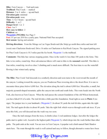
Hike: Fern Canyon — Trail and routeTrailhead: Pine Creek — markedDistance: 2 or 4 miles — up and backElevation gain: minimalElevation peak: noneTime: 1.5 to 3 hours – up and backDifficulty: 1 or 2Danger level: 1 or 2Class: 1or 3How easy to follow: 2Children: noWaypoints (WGS84): See Page 5Fees: 7 per car; 30 for a yearly pass. National Park Pass accepted.Best season: Spring and autumnDriving directions: From the Mirage on Las Vegas Boulevard (the Strip) go north three miles and turn left(west) onto Charleston Boulevard. Drive 16 miles on Charleston to Red Rock Canyon. The signed parking areafor Pine Creek Canyon is 10.3 miles past the fee booth. Waypoint 1 is the trailhead.Comments: This hike has various stopping points. Once in the wash it’s less than 100 yards to the ferns. Thishike is two miles, round trip. More adventurous hikers will want to hike to the seasonal waterfall. This hike isfour miles, round trip, involves class 3 climbing and is much more difficult. The best time to see the waterfallflowing is late winter/early spring.The Hike: Pine Creek Trail descends in a southerly direction and soon turns to the west toward the mouth ofthe canyon. Looking toward the canyon, you see Ponderosa Pines towering above the desert floor. It is rare toencounter these pines below 6,000 feet. The elevation along the trail is about 4,000 feet. Mescalito, a small, butmajestic pyramid-shaped mountain, splits the canyon into north and south forks. This route heads into the NorthFork, also known as Fern Canyon. When the trail passes the cement foundation of the old Wilson homestead,you have hiked 0.8 of a mile. The trail divides a little past this foundation. Head right as seen in Photo 1 (nosign). The juniper tree is your landmark. (Waypoint 2 ) In about 30 yards the trail divides; again take the rightfork. The trail again divides in about 40 yards. Take the right fork which weaves through scrub oak trees. If youmiss this fork, you will descend into the wash way too soon.Once the trail emerges from the trees, it climbs (class 1) red sandstone ledges. Just after the ledges thepaths start to spider web. Ascend to the highest path (Waypoint 3), which drops into the wash further than otherpaths. The path ends at the wash. You are now in Fern Canyon. A popular rock climb named Dark Shadowstarts here. The route through the wash is well cairned and easy to follow, though alternative routes have beenHiking Las Vegas.com1
created to avoid the excessive waterfrom snow melt.Route through Fern Canyon:Start by heading up the wash. In afew yards the route crosses the waterand then heads to the south (left) wall.You’ll come to a very pretty spot withferns. See Photo 2. This is one of thebest spots to end the hike and enjoy thebeauty of the canyon.Onto the seasonal waterfall:The route stays along the south wall formost of the way through the wash. Ina few hundred yards you come to theboulder and log. Photo 3 shows how toget past this obstacle. In a nutshell goto the right of the large boulder, thenbehind it and finally scramble up as thePhoto 1photo shows. The route then heads backalong the south wall. Soon you’ll come to the tunnel in Photo 4.Continue up the wash heading for the brushy looking chute in Photo 5. The seasonal waterfall(Waypoint 4) lies just below this chute. Photo 6 is the waterfall.Hiking Las Vegas.com2
Photo 2Photo 3Hiking Las Vegas.com3
Photo 4Photo 5Photo 6Hiking Las Vegas.com4
Waypoints:123436.12869 N36.12424 N36.12421 N36.12601 N115.47380 W115.48895 W115.49151 W115.50327 W3868 ft.4098 ft.4176 ft.4575 ft.Hiking Las Vegas.comTrailheadTrail divides at juniper treeHighest pathSeasonal waterfall5
Hiking Las Vegas.com 1 Hike: Fern Canyon — Trail and route Trailhead: Pine Creek — marked Distance: 2 or 4 miles — up and back Elevation gain: minimal Elevation peak: none Time: 1.5 to 3 hours - up and back Difficulty: 1 or 2 Danger level: 1 or 2 Class: 1or 3 How easy to follow: 2 Children: no Waypoints (WGS84): See Page 5 Fees: 7 per car; 30 for a yearly pass.