Transcription
Overview for Geologic Field-Trip Guides to Mount Mazama,Crater Lake Caldera, and Newberry Volcano, OregonScientific Investigations Report 2017–5022–JU.S. Department of the InteriorU.S. Geological Survey
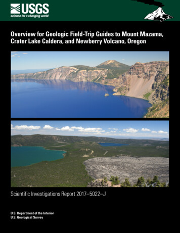
Cover (top photo): View east-northeast from Garfield Peak on the south rim of Crater Lake caldera. Peak on skyline is 8,929 feet (2,722 meters)Mount Scott, an 420 thousand years before present (ka) dacite stratovolcano considered to be part of Mount Mazama, the volcano thatcollapsed during the caldera-forming eruption 7,700 years ago. The caldera walls in this view expose Mazama lava flows and fragmentaldeposits from as old as 400 ka at Phantom Cone, adjacent to tiny Phantom Ship island, to as young as 27 ka at Redcloud Cliff, the V-shaped faceat the top of the wall left of center. The beheaded glacial valley of Kerr Notch, the low point on the caldera rim, is seen between Phantom Ship andMount Scott. Photograph by Carly McLanahan.Cover (bottom photo): Newberry Volcano, Oregon, is the largest volcano in the Cascades volcanic arc. This north-facing view taken from thevolcano’s peak, Paulina Peak (elevation 7,984 feet), encompasses much of the volcano’s 4-by-5-milewide central caldera, a volcanic depression formedin a powerful explosive eruption about 75,000 years ago. The caldera’s two lakes, Paulina Lake (left) and the slightly higher East Lake (right), are fedin part by active hot springs heated by molten rock (magma) deep beneath the caldera. The Central Pumice Cone sits between the lakes. The mostlytreeless, 1,300-year-old Big Obsidian Flow, youngest lava flow on the volcano, is surrounded by forest south of the lakes. Photograph by Robert Jensen.
Overview for Geologic Field-Trip Guides toMount Mazama, Crater Lake Caldera, andNewberry Volcano, OregonBy Charles R. Bacon, Julie M. Donnelly-Nolan, Robert A. Jensen, andHeather M. WrightScientific Investigations Report 2017–5022–JU.S. Department of the InteriorU.S. Geological Survey
U.S. Department of the InteriorRYAN K. ZINKE, SecretaryU.S. Geological SurveyWilliam H. Werkheiser, Acting DirectorU.S. Geological Survey, Reston, Virginia: 2017For more information on the USGS—the Federal source for science about the Earth, its natural and livingresources, natural hazards, and the environment—visit https://www.usgs.gov or call 1–888–ASK–USGS.For an overview of USGS information products, including maps, imagery, and publications,visit https://store.usgs.gov.Any use of trade, firm, or product names is for descriptive purposes only and does not imply endorsement by theU.S. Government.Although this information product largely is in the public domain, it may also contain copyrighted materials as notedin the text. Permission to reproduce copyrighted items must be secured from the copyright owner.Suggested citations:Bacon, C.R., Donnelly-Nolan, J.M., Jensen, R.A., and Wright, H.M., 2017, Overview for Geologic Field-Trip Guides toMount Mazama, Crater Lake Caldera, and Newberry Volcano, Oregon: U.S. Geological Survey Scientific InvestigationsReport 2017–5022–J, 3 p., https://doi.org/10.3133/sir20175022J.ISSN 2328-0328 (online)
iiiPrefaceThe North American Cordillera is home to a greater diversity of volcanic provinces than anycomparably sized region in the world. The interplay between changing plate-margin interactions,tectonic complexity, intra-crustal magma differentiation, and mantle melting have resultedin a wealth of volcanic landscapes. Field trips in this series visit many of these landscapes,including (1) active subduction-related arc volcanoes in the Cascade Range; (2) flood basaltsof the Columbia Plateau; (3) bimodal volcanism of the Snake River Plain-Yellowstone volcanicsystem; (4) some of the world’s largest known ignimbrites from southern Utah, central Colorado,and northern Nevada; (5) extension-related volcanism in the Rio Grande Rift and Basin andRange Province; and (6) the spectacular eastern Sierra Nevada featuring Long Valley Calderaand the iconic Bishop Tuff. Some of the field trips focus on volcanic eruptive and emplacementprocesses, calling attention to the fact that the western United States provides opportunities toexamine a wide range of volcanological phenomena at many scales.The 2017 Scientific Assembly of the International Association of Volcanology and Chemistry ofthe Earth’s Interior (IAVCEI) in Portland, Oregon, marks the first time that the U.S. volcanologicalcommunity has hosted this quadrennial meeting since 1989, when it was held in Santa Fe, NewMexico. The 1989 field-trip guides are still widely used by students and professionals alike. Thisnew set of field guides is similarly a legacy collection that summarizes decades of advances inour understanding of magmatic and tectonic processes of volcanic western North America.The field of volcanology has flourished since the 1989 IAVCEI meeting, and it has profited fromdetailed field investigations coupled with emerging new analytical methods. Mapping hasbeen enhanced by plentiful major- and trace-element whole-rock and mineral data, technicaladvances in radiometric dating and collection of isotopic data, GPS (Global Positioning System)advances, and the availability of lidar (light detection and ranging) imagery. Spectacularlyeffective microbeam instruments, geodetic and geophysical data collection and processing,paleomagnetic determinations, and modeling capabilities have combined with mapping toprovide new information and insights over the past 30 years. The collective works of theinternational community have made it possible to prepare wholly new guides to areas across thewestern United States. These comprehensive field guides are available, in large part, becauseof enormous contributions from many experienced geologists who have devoted entire careersto their field areas. Early career scientists are carrying forward and refining their foundationalwork with impressive results.Our hope is that future generations of scientists as well as the general public will use thesefield guides as introductions to these fascinating areas and will be enticed toward furtherexploration and field-based research.Michael Dungan, University of OregonJudy Fierstein, U.S. Geological SurveyCynthia Gardner, U.S. Geological SurveyDennis Geist, National Science FoundationAnita Grunder, Oregon State UniversityJohn Wolff, Washington State UniversityField-trip committee, IAVCEI 2017
iv125 120 Mount St. Helens (C, D, E, F)NGTOMountAdamsC olumbia RiverPortlandSouth Sister (I)50 NPullmanMONTANBozemanONHigh Lava Plains(M, O)akSnKlamathFallseBasinMedicineandLakeRange(I, K1)Province (M, N)40 AOREGBendCrater Lake (J1, M)Yellowstone (P, Q)IDAHOR iver45 Idaho FallsWYOMINGLassenPeak (K2)San Jo aquAUTAHLong ValleyCaldera (L)riveDenvererMammothMountain (L)40 COLORADOiv eoRrICPACIFR ivSalt LakeCityNEVADMonoLakeinGreatSalt LakeRenoLakeTahoeGreenRSacra m e nto RiverSan FranciscoCANADAColumbiaPlateau (M, N, O)MountJeffersonNewberry Volcano(H, I, J2, M)105 aWASHI45 ANOCECALIFORNorad35 GlacierPeak ColumbiSeattleMount Hood (F, G)Mount Shasta (K3)110 MountBakerMount Rainier (A, B)Sand MountainVolcanic Field (H)115 R i ver130 IASouthern Rocky MountainVolcanic Field (R)CreedeCo lVallesCaldera (R)Los AngelesSanta FeSaltonSea30 NEW MEXICOranRioGVolcano visited by field trip(see list on next page)Volcanic field visited by field trip(see list on next page)Other notable volcanoLetters A–R refer to chapters of the geologic field-tripguide collection published as U.S. Geological SurveyScientific Investigations Report 2017–5022120 35 deEXPLANATIONARIZONA115 Map of the western United States showing volcanoes and volcanic fields visited bygeologic field trips scheduled in conjunction with the 2017 meeting of the InternationalAssociation of Volcanology and Chemistry of the Earth’s Interior (IAVCEI) in Portland,Oregon, and available as chapters in U.S. Geological Survey Scientific InvestigationsReport 2017–5022. Shaded-relief base from U.S. Geological Survey National ElevationDataset 30-meter digital elevation model data.MEXICO110 105 00100100200200300300400500400 MILES600 KILOMETERS
vChapterletterTitleAField-Trip Guide to Volcanism and Its Interaction with Snow and Ice at Mount Rainier,WashingtonBField-Trip Guide to Subaqueous Volcaniclastic Facies in the Ancestral Cascades Arc inSouthern Washington State—The Ohanapecosh Formation and Wildcat Creek BedsCField-Trip Guide for Exploring Pyroclastic Density Current Deposits from the May 18, 1980,Eruption of Mount St. Helens, WashingtonDField-Trip Guide to Mount St. Helens, Washington—An Overview of the Eruptive Historyand Petrology, Tephra Deposits, 1980 Pyroclastic Density Current Deposits, and theCraterEField-Trip Guide to Mount St. Helens, Washington—Recent and Ancient VolcaniclasticProcesses and DepositsFGeologic Field-Trip Guide of Volcaniclastic Sediments from Snow- and Ice-CappedVolcanoes—Mount St. Helens, Washington, and Mount Hood, OregonGField-Trip Guide to Mount Hood, Oregon, Highlighting Eruptive History and HazardsHField-Trip Guide to Mafic Volcanism of the Cascade Range in Central Oregon—AVolcanic, Tectonic, Hydrologic, and Geomorphic JourneyIField-Trip Guide to Holocene Silicic Lava Flows and Domes at Newberry Volcano,Oregon, South Sister Volcano, Oregon, and Medicine Lake Volcano, CaliforniaJOverview for Geologic Field-Trip Guides to Mount Mazama, Crater Lake Caldera, andNewberry Volcano, OregonJ1Geologic Field-Trip Guide to Mount Mazama and Crater Lake Caldera, OregonJ2Field-Trip Guide to the Geologic Highlights of Newberry Volcano, OregonKOverview for Geologic Field-Trip Guides to Volcanoes of the Cascades Arc in NorthernCaliforniaK1Geologic Field-Trip Guide to Medicine Lake Volcano, Northern California, Including LavaBeds National MonumentK2Geologic Field-Trip Guide to the Lassen Segment of the Cascades Arc, NorthernCaliforniaK3Geologic Field-Trip Guide to Mount Shasta Volcano, Northern CaliforniaLGeologic Field-Trip Guide to Long Valley Caldera, CaliforniaMField-Trip Guide to a Volcanic Transect of the Pacific NorthwestNField-Trip Guide to the Vents, Dikes, Stratigraphy, and Structure of the Columbia RiverBasalt Group, Eastern Oregon and Southeastern WashingtonOField-Trip Guide to Flood Basalts, Associated Rhyolites, and Diverse Post-PlumeVolcanism in Eastern OregonPField-Trip Guide to the Volcanic and Hydrothermal Landscape of Yellowstone Plateau,Montana and WyomingQField-Trip Guide to the Petrology of Quaternary Volcanism on the Yellowstone Plateau,Idaho and WyomingRField-Trip Guide to Continental Arc to Rift Volcanism of the Southern RockyMountains—Southern Rocky Mountain, Taos Plateau, and Jemez Volcanic Fields ofSouthern Colorado and Northern New Mexico
viContributing AuthorsBoise State UniversityBrittany D. BrandNicholas PollockColgate UniversityKaren HarppAlison KoleszarDurham UniversityRichard J. BrownEastern Oregon UniversityMark L. FernsPortland State UniversityJonathan H. Fink (also withUniversity of British Columbia)Martin J. StreckAshley R. StreigSan Diego State UniversityVictor E. CampSmithsonian InstitutionLee SiebertETH ZurichOlivier BachmannUniversidad NacionalAutónoma de San Luis PotosiDamiano SarocchiGeorgia Institute ofTechnologyJosef DufekUniversity of California, DavisKari M. CooperGNS Science, NewZealandNatalia I. DeligneHamilton CollegeRichard M. ConreyMassachusetts Institute ofTechnologyTimothy GroveNational ScienceFoundationDennis Geist (also withColgate University andUniversity of Idaho)New Mexico Bureau ofGeology and MineralResourcesPaul W. BauerWilliam C. McIntoshMatthew J. ZimmererNew Mexico StateUniversityEmily R. JohnsonNortheastern UniversityMartin E. RossOregon Department of Geologyand Mineral IndustriesWilliam J. BurnsLina MaIan P. MadinJason D. McClaughryOregon State UniversityAdam J.R. KentUniversity of LiverpoolPeter B. KokelaarUniversity of NorthernColoradoSteven W. AndersonUniversity of OregonIlya N. BindermanMichael A. DunganDaniele Mckay (also withOregon State University andOregon State University,Cascades)University of PortlandKristin SweeneyUniversity of TasmaniaMartin JutzelerJocelyn McPhieUniversity of UtahJamie FarrellU.S. Army Corps ofEngineersKeith I. KelsonU.S. Forest ServiceGordon E. Grant (also withOregon State University)U.S. Geological SurveyCharles R. BaconAndrew T. CalvertChristine F. ChanRobert L. ChristiansenMichael A. ClynneMichael A. CoscaJulie M. Donnelly-NolanBenjamin J. DrenthWilliam C. EvansJudy FiersteinCynthia A. GardnerV.J.S. GrauchChristopher J. HarpelWes HildrethRichard P. HoblittRobert A. JensenPeter W. LipmanJacob B. LowensternJon J. MajorSeth C. MoranLisa A. MorganLeah E. MorganL.J. Patrick MufflerJim O’ConnorJohn S. PallisterThomas C. PiersonJoel E. RobinsonJuliet Ryan-DavisKevin M. ScottWilliam E. ScottWayne (Pat) ShanksDavid R. SherrodThomas W. SissonMark Evan SteltenWeston ThelenRen A. ThompsonKenzie J. TurnerJames W. VallanceAlexa R. Van EatonJorge A. VazquezRichard B. WaittHeather M. WrightU.S. Nuclear RegulatoryCommissionStephen Self (also with University ofCalifornia, Berkeley)Washington State UniversityJoseph R. BoroOwen K. NeillStephen P. ReidelJohn A. WolffAcknowledgmentsJuliet Ryan-Davis and Kate Sullivancreated the overview map, andVivian Nguyen created the coverdesign for this collection of field-tripguide books. The field trip committeeis grateful for their contributions.
viiContentsPreface. iiiContributing Authors. viOverview for Geologic Field-Trip Guides to Mount Mazama, Crater Lake Caldera, and NewberryVolcano, Oregon. 1References Cited. 3Figure1. Shaded-relief map of central Oregon showing Crater Lake and Newberry Volcano as wellas place names and principle roads relevant to IAVCEI 2017 field trip. 2
Overview for Geologic Field-Trip Guides to Mount Mazama,Crater Lake Caldera, and Newberry Volcano, OregonBy Charles R. Bacon, Julie M. Donnelly-Nolan, Robert A. Jensen, and Heather M. WrightThese field-trip guides were written for the occasion ofthe International Association of Volcanology and Chemistry ofthe Earth’s Interior (IAVCEI) quadrennial scientific assemblyin Portland, Oregon, in August 2017. The guide to MountMazama and Crater Lake caldera is an updated and expandedversion of the guide (Bacon, 1989) for part of an earlier IAVCEItrip to the southern Cascade Range. The guide to NewberryVolcano describes the stops included in the 2017 field trip.Locations of the two volcanoes are shown on figure 1. CraterLake and Newberry are the two best-preserved and most recentcalderas in the Cascades Volcanic Arc. Although located indifferent settings in the arc, with Crater Lake on the arc axisand Newberry in the rear-arc, both volcanoes are located at theintersection of the arc and the northwest corner region of theextensional Basin and Range Province.The overarching theme that connects the two volcaniccenters is possession of similar-sized 6- to 10-kilometer(km)-diameter collapse calderas, common in volcanic arcs butrelatively small in the spectrum of caldera size and eruptedvolume (Smith, 1979; Lipman, 1997). Few Quaternary calderasare known or implied to exist in the Cascades Arc (Hildreth,2007; Nathenson and others, 2012). Youngest is Crater Lakecaldera that collapsed 7,700 years ago during the 50 cubickilometer (km3) climactic eruption of Mount Mazama, thevolcanic edifice at Crater Lake (Bacon and Lanphere, 2006).Newberry caldera, formed 75 thousand years ago (ka)(Donnelly-Nolan and others, 2011) during a 50 km3 explosiveeruption, is the youngest of three calderas at Newberry. Twoadditional calderas nearby are inferred on the basis of ash-flowtuffs erupted 300 and 170 ka, northwest of Newberry Volcanofrom the arc axis where the Three Sisters volcanoes sit atop thearc crest. Another caldera dates from 180 ka at the MedicineLake rear-arc volcano (Donnelly-Nolan, 2010) 100 miles(160 km) south of Crater Lake, also where Basin and Rangeextension impinges on the arc.Both Mount Mazama and Newberry volcanoes have existedsince at least 400 ka and have erupted a diversity of magmatypes. Mazama eruptive products range from basaltic andesiteto rhyodacite (Bacon and Lanphere, 2006), whereas Newberrylava compositions range from basalt to rhyolite (Jensen andothers, 2009). Abundance of andesite and dacite resulted in aMazama edifice composed of overlapping stratocones whereas adominance of basaltic andesite led to more shield-like Newberry.The presence of mafic eruptive products with diverse geochemicalsignatures in the vicinity of both volcanoes is evidence for nearlydry and more hydrous mantle melt-generation processes (forexample, high-alumina olivine tholeiite [HAOT] and typicalarc basalt/basaltic andesite). Subduction-related flux meltingdominates at Crater Lake (Bacon, 1990) but is also an importantprocess at Newberry (Till and others, 2013; Mandler and others,2014). McCrory and others (2012) project the depth to theJuan de Fuca slab to be 75 km beneath Mazama and 100 kmunder Newberry, although few recorded earthquake hypocentersconstrain slab depth in this part of the arc. Nevertheless, bothvolcanoes illustrate aspects of arc volcanism and are worthysubjects for IAVCEI and other geological field excursions.
2 Overview for Geologic Field-Trip Guides to Mount Mazama, Crater Lake Caldera, and Newberry Volcano, Oregon122 121 26Detroit97MountJeffersonMadrasPeter SkeneOgden State Park20ThreeSistersBendrveD eschutesRiMountBachelor44 La PineDes chu tes RirveNewberryVolcanoL ittpqua Riv e rUmle97138ChemultDiamondLakeEXPLANATIONElevation (in feet)13823043 8,500Crater Lake7,500Rog u e River6,5005,500624,5003,5002,5001,50062001020 MILES2550 KILOMETERSHillshade base derived from U.S. Geological Survey National elevation dataset 30-meter digital elevation modelFigure 1. Shaded-relief map of central Oregon showing Crater Lake and Newberry Volcano as well as place names andprinciple roads relevant to IAVCEI 2017 field trip.
References Cited 3References CitedBacon, C.R., 1989, Mount Mazama and Crater Lake caldera,Oregon, in Chapin, C.E., and Zidek, J., eds., Field excursionsto volcanic terranes in the western United States, Volume II—Cascades and Intermountain West: New Mexico Bureau of Minesand Mineral Resources Memoir 47, p. 203–211.Bacon, C.R., 1990, Calc-alkaline, shoshonitic, and primitivetholeiitic lavas from monogenetic volcanoes near Crater Lake,Oregon: Journal of Petrology, v. 31, p. 135–166.Bacon, C.R., and Lanphere, M.A., 2006, Eruptive history andgeochronology of Mount Mazama and the Crater Lake region,Oregon: Geological Society of America Bulletin, v. 118,nos. 11–12, p. 1331–1359.Donnelly-Nolan, J.M., 2010, Geologic map of MedicineLake volcano, northern California: U.S. Geological SurveyScientific Investigations Map 2927, scale 1:50,000, https://pubs.usgs.gov/sim/2927/.Lipman, P.W., 1997, Subsidence of ash-flow calderas—Relation to caldera size and magma-chamber geometry:Bulletin of Volcanology, v. 59, p. 198–218.Mandler, B.E., Donnelly-Nolan, J.M., and Grove, T.L.,2014, Straddling the tholeiitic/calc-alkaline transition—The effects of modest amounts of water on magmaticdifferentiation at Newberry Volcano, Oregon: Contributionsto Mineralogy and Petrology, v. 168:1066, 25 p.,doi:10.1107/s00410-014-1066-7.McCroy, P.A., Blair, J.L., Waldhauser, F., and Oppenheimer,D.H., 2012, Juan de Fuca slab geometry and itsrelation to Wadati-Benioff zone seismicity: Journalof Geophysical Research, v. 117, B09306, 23 p.,doi:10.1029/2012JB009407.Donnelly-Nolan, J.M., Stovall, W.K., Ramsey, D.W., Ewert,J.W., and Jensen, R.A., 2011, Newberry Volcano—CentralOregon’s Sleeping Giant: U.S. Geological Survey Fact Sheet2011–3145, 6 p., https://pubs.usgs.gov/fs/2011/3145/.Nathenson, M., Clynne, M.A, and Muffler, L.J.P., 2012,Eruption probabilities for the Lassen Volcanic Center andregional volcanism, northern California, and probabilitiesfor large explosive eruptions in the Cascade Range: U.S.Geological Survey Scientific Investigations Report 2012–5176–B, 23 p., http://pubs.usgs.gov/sir/2012/5176/b/.Hildreth, W., 2007, Quaternary magmatism in the Cascades—Geologic perspectives: U.S. Geological Survey ProfessionalPaper 1744, 125 p., https://pubs.usgs.gov/pp/pp1744/.Smith, R.L., 1979, Ash-flow magmatism, in Chapin, C.E., andElston, W.E., eds., Ash-flow tuffs: Geological Society ofAmerica Special Paper 180, p. 5–27.Jensen, R.A., Donnelly-Nolan, J.M., and Mckay, D., 2009, A fieldguide to Newberry Volcano, Oregon, in O’Connor, J.E., Dorsey,R.J., and Madin, I.P., eds., Volcanoes to Vineyards—GeologicField Trips through the Dynamic Landscape of the PacificNorthwest: Geological Society of America Field Guide 15,p. 53–79, doi:10.1130/2009.fl d015(03).Till, C.B., Grove, T.L., Carlson, R.W., Donnelly-Nolan,J.M., Fouch, M.J., Wagner, L.S., and Hart, W.K., 2013,Depths and temperatures of asthenopheric melting andthe lithosphere-asthenosphere boundary in the southernCascades arc and back-arc: Geochemistry, Geophysics,Geosystems, v. 14, no. 4, p. 864–879.Menlo Park Publishing Service Center, CaliforniaManuscript approved June 19, 2017Edited by Sarah NagorsenLayout by Cory Hurd
Bacon and others—Overview for Geologic Field-Trip Guide to Mount Mazama, Crater Lake Caldera, and Newberry Volcano, Oregon—Scientific Investigations Report 2017–5022–JISSN 2328-0328 (online)https://doi.org/10.3133/sir20175022J
ISSN 2328-0328 (online) iii Preface . community has hosted this quadrennial meeting since 1989, when it was held in Santa Fe, New Mexico. The 1989 field-trip guides are still widely used by students and professionals alike. . Klamath Falls Pullman Salt Lake City Co lu m b ia Ri ve r C ol u m b i a R i v e r Mount Rainier A, B Yellowstone P .