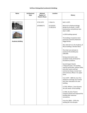
Transcription
HO-73Ellicott Mill Original Historic SiteArchitectural Survey FileThis is the architectural survey file for this MIHP record. The survey file is organized reversechronological (that is, with the latest material on top). It contains all MIHP inventory forms, NationalRegister nomination forms, determinations of eligibility (DOE) forms, and accompanying documentationsuch as photographs and maps.Users should be aware that additional undigitized material about this property may be found in on-sitearchitectural reports, copies of HABS/HAER or other documentation, drawings, and the “vertical files” atthe MHT Library in Crownsville. The vertical files may include newspaper clippings, field notes, draftversions of forms and architectural reports, photographs, maps, and drawings. Researchers who need athorough understanding of this property should plan to visit the MHT Library as part of their researchproject; look at the MHT web site (mht.maryland.gov) for details about how to make an appointment.All material is property of the Maryland Historical Trust.Last Updated: 05-03-2004
/-HO 73, Ellicotts Lower Mills Sites,1772, 1809, ca. 1870, 1917-1918.Ellicott City vicinity, llchester area, private access.Capsule Summary, page 1.This document updates the existing Inventory form.Description:Much important evidence has come to light concerning theoriginal appearance and later changes made to Ellicotts Lower Mills.In particular the records of the 1798 Federal Direct Tax, whichdetail not only the original stone merchant mill, but also the fullcomplex of ten industrial and craft structures, four ancillarybuildings, a meeting house, sixteen dwellings and ten residentialoutbuildings.Deeds, illustrations, and newspaper stories are amongthe pieces of evidence that relate the evolution of the complex afterthe 1809 fire which destroyed the original mill building.Thesuccessor mill--alone of others nearby--survived the destructiveJuiy1868 flood, and it is an addition made to this second mill in theearly 1870s which survives in part today.The addition comprisestwo, two-story stone units, one with a gable and the other with aflat roof;they were sited at the extreme southern end of thebuilding, and contained a boiler and steam engine.The tall squarechimney, with a stone base and brick shaft, now truncated and
-HO 73, Ellicotts Lower Mills Sites,1772, 1809, ca. 1870, 1917-1918.Ellicott City vicinity, llchester area, private access.Capsule Summary, page 2.contained within a later brick wall was attached to the gable end ofthe southernmost unit, given the letter designation "A" in a series ofSanborn Fire Insurance maps.The other unit was noted "B."Thesetwo alone survived a fire, and were re-faced and attached to thelarge replacement mills of Italianate character built on the site ofthe previous structure in 1917 and 1918.The cornerstone of the1809 mill survives, but not in situ.-Significance:The significance of Ellicott's Mills in the history of thePatapsco River Valley can hardly be overestimated.Theseoperations, which Joseph ( 1732-1780), Nathaniel ( 1736-1797).Andrew ( 1734-1809), and John (1739-1795) Ellicott began to installin 1771,mark a maturing of the colonial economic system.Thenjust opening to crop diversification, colonial Maryland's tobaccoproducers were experimenting with grain--particularly wheat--asan alternative.-The brothers not only responded to this trend butactively sought to shape and direct its development into a new anddominant economic reality.Undertaking to establish not simply a
-HO 73, Ellicotts Lower Mills Sites,1772, 1809, ca. 1870, 1917-1918.Ellicott City vicinity, llchester area, private access.Capsule Summary, page 3.flour mill--even a large scale mill--they more importantlypromoted an entire integrated system of cultivation, production,shipping, and labor, a far more complex economic entity than hadbeen attempted before in the valley by industrial investors.Inessence, they built the first factory town in Maryland conceived on arecognizably modern model, a model which would becomecharacteristic of America's later industrial development.The extraordinary scale of their operations, the diversity ofindustrial and social functions they served, and the consequenteffects on the development of the Patapsco Valley, on the growth ofthe city and port of Baltimore, and on the progress ofindustrialization in the new Republic are among the most importantcharacteristics and effects of the milling community they founded.-
Inventory Number HO 73Ellicotts Lower Mills Sites, Baltimore and Howard CountiesMaryland Comprehensive State Historic Preservation PlanStatewide Historic ContextsGeographic Organization:PiedmontChronological Development/Periods:9) Rural Agrarian Intensification10) Agricultural-Industrial Transition11) Industrial/Urban storic Period Themes:-1)2)3)8)AgricultureCommunity PlanningEconomicTransportationResource Type:Category:SiteHistoric Environment:VillageHistoric Functions and Uses: Flour Mills; Saw Mill; Plaster Mill; Smithing,Coopering, and Wheelwright Operations, Residences, ancillary structures.Known Design Sources:-None
-Inventory Number HO 73Ellicotts Lower Mills Sites, Baltimore and Howard CountiesEllicott CitySite Description, Updated.7.1-Notwithstanding the lack of construction records for the buildings at EllicottsLower Mills, several other important sources identify many of the earlystructures erected there and provide a general chronology of development overthe eighteenth and nineteenth centuries. Land records are an obvious startingpoint, and confirm that on 24 April 1771, Joseph ( 1732-1780), Nathaniel (17361797), Andrew (1734-1809), and John (1739-1795) Ellicott purchased twotracts, including the one on which they would erect the merchant mill that boretheir name (Baltimore AL C/680). In December of 1774, the brothers purchasedadditional acreage along the western ·bank of the Patapsco, opposite the mill, tothe north and south of Tiber Branch (Anne Arundel IB 5/134). These three tractscontained the all the sites of the initial building campaigns at the Lower Mills.Martha Ellicott Tyson described the first buildings in her 1865 memoir.She states that the original 100-foot mill house in Baltimore County was openedin 177 4, accompanied by a temporary log dwelling for the mechanics(construction workers) and laborers. Following these, over the next decade and ahalf, the brothers completed a variety of supporting structures on both sides ofthe river: a saw mill, stone and frame dwellings for "the workmen engaged in thewheelwright shop," the Ellicott family dwellings, a large stable, a school, andfinally a large stone warehouse and store, run by Samuel Godfrey (Tyson, pp. 5-8,15-16). The Ellicotts evidently concentrated on getting the flour milloperational first, then expanded their collection of ancillary structures, aprogression consistent with the records of land purchases, noted above. Amongthese ancillary buildings, however, was a complex not recalled in Tyson'smemoir. A half mile southeast of the lower mills, the Ellicotts established adistillery on the Baltimore-County bank of the Patapsco. This installationincluded "a large and very convenient still house, with three" 150 gallon stills, amalt house, dwelling house, and other improvements. It passed out of the familyrelatively quickly; "Godfrey and Ellicott" offered it for sale in January 1779(Maryland Journal, 19 January 1779).In the mid-1780s, George Ellicott (1760-1832), a grandson of Andrew,illustrated the state of building at the family's mills. His sketch of structureson the Baltimore-County side of the river includes John and Jonathan Ellicott'sresidences, a warehouse, and two unidentified structures--probably a laborer'sdwelling and a barn--all across the road from the mills, then a stable, shop,unidentified building, saw mill, flour mill, and store between the road and the
-Inventory Number HO 73Ellicotts Lower Mills Sites, Baltimore and Howard CountiesEllicott CitySite Description, Updated.7.2-river's edge. The saw mill was parallel to the river, and sited adjacent, but notconnected to the flour mill, which was built perpendicular to the river. Waterturning the wheel on the river end of the flour mill drove the grinding apparatus,and a gable roof with dormer windows sheltered the two-story structure (seeArchive Images .1, in this update). At least one bridge linked these buildings inBaltimore County to that portion of the complex in what was then Anne ArundelCounty. Buildings there along the west bank of the river included awheelwright's shop, dwellings, and a school house. The Ellicotts also surveyed aroad through this milling community, reorienting the Baltimore and FrederickTown Turnpike; it spanned the river at a new bridge in 1791 (Baltimore CountyCourt, Plats, 1 November 1791 ).Thus by 1798, when Federal assessors made the most thorough survivinginventory of eighteenth-century structures at the mills, the Ellicotts hadestablished a community of some ten industrial and craft structures, with fourancillary buildings, a meeting house, sixteen dwellings, and ten residentialoutbuildings (Federal Direct Tax Records, Baltimore and Anne Arundel Counties).In addition, the complex included a dam and millrace-, a quarry, and a publiclyfunded highway and bridge (for the quarry, see: Baltimore County PatentedCertificate 245). The assessors noted that the flour mill was thirty-six by onehundred feet, constructed of stone, and the saw mill fourteen feet by sixty,evidently of frame.The early nineteenth century saw additions of four industrial structures,recorded in a geography of Maryland published in 1807 and in Anne ArundelCounty land records. Joseph Scott, author of the Geographical Description, notedthe flour and saw mills, and described three new installations: a mill forpulverizing plaster of Paris and an iron rolling and slitting mill--both inBaltimore County--and an oil mill, sited on Tiber Branch in Anne Arundel County(Scott, pp. 91, 92. For the Iron mill, see Inventory Number BA 2810). Theoriginal flour mill burned on the night of 11 January 1809, and was replacedimmediately ([Baltimore] American and Commercial Daily Advertiser, 12 January1809). By 1812, the Ellicotts had added a country mill, or small-scale gristmill, to the complex in Baltimore County (Anne Arundel WSG 2/119); thisstructure, later known as the Chesapeake Mill, was swept away with the groundon which it stood in the flood of 1868 (Baltimore American, 27 July 1868, pp. 1,4).
-Inventory Number HO 73Ellicotts Lower Mills Sites, Baltimore and Howard CountiesEllicott CitySite Description, Updated.7.3--A deed of 1823 gives the relative positions of the 1809 (or Patapsco) mill,the site of the 1772 mill, and the country (or Chesapeake) mill. All three stoodon the east bank of the Patapsco, between the Baltimore Turnpike and the river.Moving up stream, to the north, the Chesapeake Mill came first, next thefoundation of the "old burnt mill," and then the Patapsco Mill (Baltimore WG169/469 and Anne Arundel WSG 10/85). In 1838, the Chesapeake Mill was asixty by thirty-foot structure, and according to the Baltimore American report ofthe flood, cited above, stood about one hundred yards southeast of the PatapscoMill. The same 1838 reference, an advertisement for sale, dimensioned thePatapsco Mill at forty-five by fifty feet, a measurement consistent with the1887 Sanborn Fire Insurance Map of the complex (Baltimore American, 30 July1838, col. 15; and Sanborn Maps, Ellicott City, 1887, Map Three--see ArchiveImages .6 in this update).The last major construction before the Ellicott family lost the mills in 1841resulted from the approach of the Baltimore and Ohio Railroad. In 1828,Nathaniel H. Ellicott (1791-?), a grandson of Andrew, reminded Philip Thomas,the president of the B & 0, to be mindful of his promise "to make some provisionas to a suitable turn out place for the accommodation of our Mill (James, p.295)." Civil engineers for the railroad raised a trestle across the river to thePatapsco Mill in 1830 or 1831 (Second Annual Engineers Report, p. 22), and thistoo was destroyed in the 1868 flood (Harper's Weekly, 15 August 1868, p. 521 ).Both the Patapsco and Chesapeake Mills and the railroad trestle were illustratedin John Schofield's lithograph of the Patapsco Valley, ca. 1860 (see ArchiveImages .4, in this update).The later evolution of the Patapsco Mi II itself may be largely traced bycomparing a photograph made after the flood with the series of maps executedfor the Sanborn Fire Insurance Company between 1887 and 1959 (Archive Images.5 and forward, in this update). The 1809 mill had been expanded in a series offive clearly-demarcated additions, each one given a letter designation in theSanborn maps. Each one of these additions is visible also in the post-floodphotograph; proceeding away from the viewer in the photograph, these sectionsrun from the chimney of the building: A, under the gable roof; B, with a flatroof; C, with three bays of windows and two of dormers; D, two bays ofwindows, two of dormers; E, three bays of windows, two of dormers; and F, onebay of windows and dormers. The varied configuration of stone and frame walls
-Inventory Number HO 73Ellicotts Lower Mills Sites, Baltimore and Howard CountiesEllicott CitySite Description, Updated.7.4--visible in the photograph conforms exactly to the descriptions of each sectiongiven in the Sanborn Maps dating from 1884 to 1910.Sections D and E of the Patapsco Mill predate the flood, as shown in theHarper's Weekly illustrations (Archive Images .3 and .4). The 1838 saleadvertisement, cited above, gives dimensions of forty-five by fifty feet in itsdescription of the 1809 mill building. This corresponds to section E on theSanborn map, and is shown in the photograph and in the Harper's Weeklyillustration to have been a stone structure with a small cupola--likelycontaining a bell--at the peak of the gable above the entrance. Some time priorto the flood, but after 1838, section D was added, on a lower story of stone andframe, with frame above. It is so depicted in the Harper's Weekly illustrationand in the Baltimore American description of 27 July 1868, pp. 1 and 4, and inthe post-flood photograph.In the substantial rebuilding undertaken after the flood, the damagednorthwest corner of Section E was rebuilt, and Sections A, B, C, and F wereadded. The photograph, then, was taken to commemorate this completed form ofthe building, and its angle of view privileges the dominant smoke stack, boiler,and engine rooms of the modernized facility (Sections A and B). Charles A.Gambrill and Company had invested in the latest factory technology--a steamengine--and chose to emphasize that fact in this depiction of the mill building.Note that the original facade of the mill, still marked by the cupola, has beencompletely obscured; the new front might just as easily be the stone sectionwith the imposing chimney, a reversal of the former mill's orientation.Gambrill and Company operated the mills under lease from Charles Carroll,who had acquired the property as a foreclosure in 1844 (Baltimore TK 348164).The Gambrill company purchased the mills in its own right four months after theflood of 1868 (Baltimore 591465), and continued to operate them with two otherfacilities: the Orange Grove Mill (see Inventory Number BA 2808), and, later, anestablishment in Baltimore City. Alterations to the Orange Grove facility andthe plant on Smith's Wharf, off Pratt Street in Baltimore, suggest parallelchanges at Ellicott City. Gambrill added a steam engine to the Orange Grove Millin 1873, probably just after the renovations had been completed andphotographed at Ellicott City. In 1881-1882 Gambrill opened the Baltimoreplant, "Mill B," with the first metal roller system to be used the state. The nextyear, 1883, Gambrill installed this new vertical roller system in the mill at
-Inventory Number HO 73Ellicotts Lower Mills Sites, Baltimore and Howard CountiesEllicott CitySite Description, Updated.7.5--Orange Grove, which necessitated the replacement of the original gable roof withanother full story and shallow attic (McGrain, "Good Bye," pp. 157, 159; Phillips,p. 41 ). By 1887, at Ellicott City, the Sanborn maps describe a four-and-a-halfstory mill building which--as the post-flood photograph shows--originallycomprised three stories with two tiers of dormers in the attic. Gambrill didraise the roof of the Patapsco Mill at Ellicott City, and since none of the Sanbornmaps indicate such a change after 1887, the renovation had to have beenaccomplished earlier. Very likely, after metal rollers were installed at theBaltimore City mill in 1881-82, and at Orange Grove in 1883, Gambrill moved tomake the same improvements at his third facility, "Mill A," at Ellicott City.The Sanborn maps do reveal three significant changes to the Patapsco Millafter 1887. On 6 April 1890 the Baltimore and Ohio Railroad acquired land fromGambrill for the construction of a new trestle to the Patapsco Mill, and thesubsequent Sanborn map, issued in 1894, shows the trestle in place (HowardCounty 55/609; see also Archive Image .7, in this update). In 1905, Gambrill'sOrange Grove Mill burned and the site was abandoned; the company consolidatedfacilities at Ellicott City, and renovated a warehouse adjacent the Patapsco Mill.This new flour mill is shown on the Sanborn map for 1910, which reveals that anaddition had been made to Sections A and B of the Patapsco Mill to accommodatethe shafting now extended to "Mill D" (see Archive Image .8). The 1919 SanbornMap, altered with pasted revisions in 1937, 1947, and 1959, shows thestructure resulting from two building campaigns in 1917 and 1918, after a firedestroyed the previous mill building. The earlier Patapsco mill's Sections A andB were with the truncated chimney base incorporated into the twentieth-centurystructures. Though these sections had been attached to the 1809 mill, no part ofthat early building survives in situ. The functions of the Orange Grovereplacement mill, "Mill D" on the 1910 Sanborn map, were then shifted to the newstructures, and the present configuration of the principal mill buildings isessentially the same as represented here on the last Sanborn map.
.-Inventory Number HO 73Ellicotts Lower Mills Sites, Baltimore and Howard CountiesEllicott CityStatement of Significance, Updated.8.1The significance of Ellicott's Mills in the history of the Patapsco River Val.laycan hardly be overestimated. These operations, which Joseph (1732-1780),Nathaniel ( 1736-1797), Andrew (1734-1809), and John ( 1739-1795) Ellicottbegan to install in 1771, mark a maturing of the colonial economic system. Thebrothers not only responded to an agricultural trend but actively sought to shapeand direct its development into a new and dominant economic reality. Theextraordinary scale of their operations, the diversity of industrial and socialfunctions they served, and the consequent effects on the development of thePatapsco Valley, on the growth of the city and port of Baltimore, and on theprogress of industrialization in the new Republic are among the most importantcharacteristics and effects of the milling community they founded.--The iron works and grist mills in place by the 1760s along the Patapsco Rivercorridor running west from Elk Ridge Landing were important but distinctlysmall-scale operations. The Elk Ridge furnace, Dorsey and Hockley forges,Cornthwaite's "Dismal" grist mill, and Hood's grist mill were the first industrialenterprises in this region; all had come into existence since 1755 (Tyson, pp. 24,32, 33, 55; McGrain, Molinography; McGrain, "Development," pp. 346, 351, 352).Production of iron and flour in a region which still counted tobacco as its firstand most important revenue source marked a growing attempt to diversify thecolonial economy. British mercantile policy had sought to prevent colonialproduction of finished goods in order to make the colonies entirely a source ofraw materials and a market for British-made products. For iron manufacture,the policy kept colonists dependent on England for tools and other items whichcould have been produced locally. Open defiance of these strictures in the thirdquarter of the eighteenth century was one in the series of steps towardindependence (Robbins, pp. 201-211 ).The predominant system of tobacco production also served to keep colonistsdependent. Planters relied on British merchant houses or factors who offeredcredit for hogsheads and resold the tobacco for their own profit. The shift in theChesapeake to wheat cultivation provided an opportunity to keep both productionand wholesale profits within colonial boundaries. Local millers and bakersproduced flour and bread for export, and colonial shippers were better positionedto serve the growing markets of the Americas. Wheat also offered relief from
-Inventory Number HO 73Ellicotts Lower Mills Sites, Baltimore and Howard CountiesEllicott CityStatement of Significance, Updated.8.2--the notorious soil depletion long associated with tobacco, and in the mideighteenth century grain crops held to more stable pricing. Pennsylvania Germansettlers in Maryland's western counties also brought to the region a populationwith a long history of expertise in grain culture (Gilbert, pp. 17-20).Against this background of increasing economic diversification the smallscale industrial operations for iron and flour had been established in the valleyof the Patapsco. Certainly the Ellicott brothers recognized and followed thisestablished trend, but they initiated a dramatic change in how industrialventures of this type were conceived and organized. Undertaking to establish notsimply a flour mill--even a large scale mill--they more importantly promoted anentire integrated system of cultivation, production, shipping, and labor, a farmore complex economic entity than had been attempted before in the valley byindustrial investors.Initially, the Ellicotts appear to have sought the assistance of the powerfulCarroll family, a politically savvy move to ensure local acceptance and supportfor this large-scale enterprise so dramatically different from the norm (Scharf,p. 24). It is probable Charles Carroll of Carrollton owned the right to construct awater mill on the land where the Ellicotts sited their own principal facility. TheMaryland Mill Act of 1669 (amended to 1766) permitted grist-mill builders tocondemn appropriate sites in twenty-acre tracts, and to obtain eighty-yearleases for the mill seats (Hart, p. 15) .The first land patent issued to theEllicott brothers noted a vacancy of 19.5 acres in the tract of thirty-four acreswhich they had purchased in 1771 of William Williams (Anne Arundel PatentedCertificate 1027; Baltimore AL C/683). This meant that Williams had actuallyconveyed fifty-five acres to the brothers, the total here including the landWilliams owned in fee simple, the twenty-acre mill seat condemned by anotherunnamed party, and the balance calculated for the surface of the waters in thePatapsco and in Tiber Branch. Additional research may reveal the character ofthe relationship between Carroll and the Ellicotts which Scharf asserted, above;a likely arrangement may have balanced Carroll's endorsement of the enterpriseand his own harvests of wheat with the Ellicotts' expertise in facilityconstruction and operation.Surviving evidence from property transfers suggests that the four brothershad first intended to operate three different facilities spaced along the river:the former Hood's mill, purchased in 1774 (Anne Arundel IB 5/139, IB 5/141, and
Inventory Number HO 73Ellicotts Lower Mills Sites, Baltimore and Howard CountiesEllicott CityStatement of Significance, Updated.8.3-'IB 5/137), the new flour mill they built on the William Williams' tract, and athird installation--a distillery--sited one half mile below their new flour millon land purchased in 1771 from Emmanuel Teal (Baltimore AL C/680). Ratherquickly, though, the brothers revised their partnership, and recast their plans. In1777, Nathaniel withdrew from the partnership and sold his share to Joseph. In1778, Joseph exchanged his share in all the downriver property for John andAndrew's portion of the Hood's mill tract, which Joseph then managed alone(Anne Arundel, NH 2/590). In 1779, John and Andrew divested themselves of thedistillery, and concentrated their attentions on the flour mill and relatedinstallations already underway on each side of the river, at the place which cameto be known as Ellicotts Lower Mills (Maryland Journal, 19 January 1779).Under John and Andrew's direction, then, the most ambitious character of theproject was realized; they invested not in mills alone, as Hood and Cornthwaitehad done a decade earlier, but in a network of related facilities. To the complexcentered on the substantial stone merchant mill--thirty-six by one hundred feetlong--they included an equally substantial stone stable, and across the river inAnne Arundel county, they sited a wheelwright's shop (Tyson, pp. 5-8, 15, 16;Federal Direct Tax Records, Baltimore and Anne Arundel Counties). Thesestructures sheltering draft horses and wagon construction and maintenancereveal the enterprise included transport of wheat and flour to market as anessential feature of the operation. To this end the Ellicotts also promoted roadbuilding. They surveyed new routes to Baltimore in 1790 and 1791, successfullypetitioning for a re-routing of the Baltimore and Frederick Town turnpikethrough the mills (Baltimore County Court, Plats, 1790-1791 ). Once inBaltimore, products of the mills found a place in Ellicott family warehousesconstructed on their own wharf at Baltimore harbor (Baltimore Fire InsuranceCompany Records). The brothers also built warehouses and shops at the mills,which provided space not only for the storage of grain and flour, but also for thesheltering of other commodities used in trade, and for smithing and coopering(barrel-making) operations (Federal Direct Tax Records, Baltimore and AnneArundel Counties). In one of the only eighteenth-century account orders at themills to survive, a farmer named Simpson, Sr. exchanged his grain crop on 15September 1791 to "Friend Ellicott . . . [for]. --1716 [worth of] 10 d nails, 2bushels fine salt . . . [with the] balance of the wheat in hobb nails (GeorgeEllicott and John Ellicott, store accounts, 177 4-1800)."
-Inventory Number HO 73Ellicotts Lower Mills Sites, Baltimore and Howard CountiesEllicott CityStatement of Significance, Updated.8.4-The Ellicotts erected a saw mill to supply themselves with the lumbernecessary for equipment, fencing, dams, bridges, and buildings; this largefacility--fourteen by sixty feet long--also served the larger community, as thequarry they opened provided ashlar blocks for themselves and the wider public(Baltimore County Patented Certificate 245). The residence John Ellicott builtfor himself and the two dwellings of his nephews, Jonathan and George, sons ofhis brother Andrew, were constructed of this stone--stating an architecturalaffinity among all the principal buildings of the enterprise. In addition to theirown residences, the brothers built a variety of dwellings for managers andlaborers in a descending hierarchy of size and materials; this industrialcommunity was to gather for religious and educational instruction at theEllicotts' stone meeting house (Federal Direct Tax Records, Baltimore and AnneArundel Counties). In sum, by the end of the eighteenth-century, the Ellicottbrothers had established a well ordered, hierarchical industrial town, comprisinga variety complementary processes integrated into a single economic entity. Allthe components--and more--of the classic nineteenth-century company towncould be found here.Innovators in many ways, the Ellicotts promoted the development of newmethods for the industry. In 1790, they installed and perhaps modifiedmechanical systems for flour mills developed by Oliver Evans. Though a patentdispute with Evans was adjudged against them, the records of the case revealtheir on-going attention to technological improvements in industry (Sharrer, pp.329, 330; Niles Register, v. 3 addenda (1813), p. 9). In addition, they promotedagricultural change--not only in the general shift from tobacco to wheat butmore particularly in the land-restoring properties of plaster. This idea came tohave great currency in educated circles at the opening of the nineteenth century,as part of a movement toward "scientific farming," and the Ellicotts encouragedits dissemination by constructing a mill to pulverize plaster of Paris for thispurpose (Scott, p. 91 ). Their brief early attempt to operate a distillery similarlyreflects a scientific attitude, open, in this case, to exploration of alternativeproducts for grain crops. Finally, time management of a large labor forcebecame a growing concern for industrialists. The new merchant mill theEllicotts erected in 1809 was surmounted by a cupola containing a bell, its pealsintended to regulate a labor force not yet accustomed to possessing individualtime-pieces.
-Inventory Number HO 73Ellicotts Lower Mills Sites, Baltimore and Howard CountiesEllicott CityStatement of Significance, Updated.8.5-The success of the Ellicott's scheme on the Patapsco encouraged theiradditional investment in an iron rolling and slitting mill, for the manufacture ofnails, tools, and sheet metal, and in the opening of a small scale grist mill toserve the local market for flour and meal (see Inventory Number BA 2810 for theiron mill). Their interests extended to real estate acquisitions elsewhere in thePatapsco Valley, to control development and water rights, and the familydeveloped additional mill seats at the site of Dorsey's forge and of Cornthwaite's"Dismal" Mill, on the Patapsco, and on Gwynn's Falls closer to Baltimor
Baltimore County--and an oil mill, sited on Tiber Branch in Anne Arundel County (Scott, pp. 91, 92. For the Iron mill, see Inventory Number BA 2810). The original flour mill burned on the night of 11 January 1809, and was replaced immediately ([Baltimore] American and Commercial Daily Advertiser, 12 January 1809).