Transcription
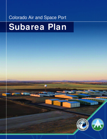
Colorado Air and Space PortSubarea Plan
Colorado Air and Space Port :Subarea PlanACKNOWLEDGMENTSBoard of County CommissionersEva J. Henry, District 1Charles “Chaz” Tedesco, District 2TABLE OF CONTENTSChapter 1 Introduction.1Plan Area.3Plan Purpose.4The Planning Process.4Emma Pinter, District 3Planning Context.5Steve O’Dorisio, District 4How To Use This Plan.5Lynn Baca, District 5Chapter 2 State of the Subarea.7Key Takeaways.8Planning CommissionChapter 3 Community Conversation. 11Steering Committee .13Justin MartinezRosie GarnerGreg ThompsonSharon RichardsonAaron HerreraJohn DupriestSean ForestScott MadduxStakeholder Focus Groups.13Community Workshops.13Plan Website .14Additional Engagement .14Plan Adoption .14Chapter 4 Vision and Goals.17Subarea Vision Elements.20Subarea Goals.20Subarea Concept Plan .21Dave RoseChapter 5 Future Land Use Plan.23Subarea Land Use Scenarios.25Additional AcknowledgmentsChapter 6 Recommendations.39Land Use and Urban Design.41Raymond Gonzalez, County ManagerMobility.45Alisha Reis, Deputy County Manager, Community Infrastructure and Development ServicesParks and Open Space.47Jim Siedlecki, Deputy County Manager, Community Services and Public InvolvementUtilities.49Ryan Nalty, Director of Economic Development, Interim Director of Community and Economic DevelopmentDave Ruppel, Director, Colorado Air and Space PortJen Rutter, Development Services ManagerNick Eagleson, Senior Strategic PlannerConsultant TeamSteven Chester, Project Manager, Kimley-HornBlake Young, Project Planner, Kimley-HornEconomic Development .50Chapter 7 Moving Forward.51Implementation Goals.52Regulatory and Policy Strategies.53Annexation and Growth Management.57Partnerships.57A Living Document.58Investment Strategies.59Appendix. A-1Jon Tuley, Project Planner, Kimley-HornArleen Taniwaki, Arland Land Use EconomicsPhil Smith, Bryce Space and Technologiesiiiii
Colorado Air and Space Port :Subarea PlanTABLE OF FIGURESACRONYMSChapter 1 Introduction.1Figure 1-1 Context Map.2AIZAirport Influence ZoneFigure 1-2 Planning Area Map.3ACREAurora Campus for Renewable EnergyFigure 1-3 Planning Process Graphic .4BIDBusiness Improvement DistrictBMPBest Management PracticesCIPCapital Improvements ProgramCASPColorado Air & SpaceportFigure 3-3 Scenario 1.15CDOTColorado Department of TransportationFigure 3-4 Scenario 2.16DENDenver International AirportEDCMetro Denver Economic Development CorporatonGIDGeneral Improvement DistrictFigure 1-4 Planned Developments.6Chapter 2 State of the Subarea.7Chapter 3 Community Conversation. 11Figure 3-1 Community Engagement Process.12Figure 3-2 Plan Website.14Chapter 4 Vision and Goals.17Figure 4-1 Subarea Vision Elements.20Figure 4-2 Concept Plan.22Chapter 5 Future Land Use Plan.23Figure 5-1 Framework Planning Process.24Figure 5-2 Future Land Use Plan.26Figure 5-3 Industry Hub Site Plan.27Figure 5-4 Industry Hub Site Map.28Figure 5-5 Aerospace and Innovation Site Plan.29Figure 5-6 Aerospace and Innovation Site Map.30Figure 5-7 Mixed-Use Industrial Site Plan.31Figure 5-8 Mixed-Use Industrial Site Map.32Figure 5-9 Green Energy and Sustainable Agriculture Site Plan.33Figure 5-10 Green Energy and Sustainable Agriculture Site Map.34Figure 5-11 Community Hub Site Plan.35Figure 5-12 Community Hub Site Map.36Figure 5-13 Neighborhood Residential Site Plan.37NEATS Northeast Area Transportation StudyPUDPlanned Unit DevelopmentPIFPublic Improvement FeeRTDRegional Transportation DistrictSCRLSecond Creek Regional Lift StationSIDSpecial Improvement DistrictTIFTax Increment FinancingUPRRUnion Pacific RailroadURAUrban Renewal AuthorityFigure 5-14 Neighborhood Residential Site Map.38Chapter 6 Recommendations.39Figure 6-1 Subarea Recommendation Topic Areas.40Figure 6-2 Future Land Use Plan.42Figure 6-3 Restricted Areas within the CASP.44Figure 6-4 Future Mobility.46Figure 6-5 Future Parks and Open Spaces Map.48Chapter 7 Moving Forward.51Figure 7-1 Character Area Zoning.53ivv
Colorado Air and Space PortSubarea PlanChapter 11Introduction1Chapter 1: IntroductionThe Colorado Air and Space Port (CASP) is poised to serve as one of the nation's hubs for commercial spacetransportation, research, and development. Colorado and the Denver-Aurora metropolitan area has a robust aerospaceindustry, including 280 aerospace relatd companies and more than 500 suppliers providing space-related products andservices. The CASP is located six miles from Denver International Airport (DEN) with regional connectivity provided byI-70 and is in proximity to the Union Pacific Railroad (UPRR) mainline. The CASP is surrounded by multiple jurisdictions,including unincorporated Adams County, the City of Aurora, the Town of Bennett, Arapahoe County, and the City andCounty of Denver. Each of these jurisdictions play a key role in development around the CASP and will be integral to thesuccess of the airport-related mixed-use employment area surrounding DEN (also referred to as the aerotropolis region).The CASP subarea, shown in Figure 1-1, is located 22 miles east of Downtown Denver in Adams County within theDenver-Aurora metropolitan area, which is expected to grow by more than one million in population by 2050. Developmentis increasing in the area, which is why it is important to envsion near- and long-term goals for the planning area. I-70,just south of the subarea, connects the subarea to the Midwest region to the east, Denver’s western suburbs, foothillscommunities, and beyond to the West. The UPRR mainline links the subarea to 23 states in the western two-thirds ofthe United States, along with connecting to Canada and Mexico's rail systems. Other municipalities and unincorporatedareas within a 30-minute drive of the subarea include Aurora and Denver to the south; Brighton and Lockbuie to thenorth; Watkins, Bennett, Strasburg, and Byers to the east; and Commerce City, Lakewood, Arvada, Wheat Ridge, andWestminster (among others) to the West.Figure 1-1 Context MapBrightonAd a m s C o u nt y 85Thornton §76Commerce CityThorntonD e nve rI nt e r n a t i o n a lAirport §270C o l o ra d o A i r a n dS p a ce Po r tS u b a re aD e nve r C o u nt y Bennett40Denver § 7040 §Aurora225A ra p a h o e C o u nt y §25Greenwood VillageCentennialFoxfield2
Colorado Air and Space PortSubarea PlanChapter 1: IntroductionThe purpose of this plan is to provide a roadmap for future growth and development that capitalizes on the area’sproximity to the CASP without creating any conflicts between future development and CASP operations, while alsobalancing the goals of existing residents and business owners. It is not too soon to meet this challenge and set a strategicvision for the subarea that will guide future development and change to the benefit of all existing and future residents,business owners, employees, property owners, and visitors.Lost Sand CrBear Gl.Peterson RdBear Gl.Quail Run RdInboden RdE 72nd AveHarback RdFigure 1-2 Planning Area MapSchumaker RdThis plan sets the vision and goals for future land use, transportation, and infrastructure decisions for the subarea andserves as a guide for public and private investment around the CASP. This plan builds upon other planning efforts andoffers plan guidance for future land uses, infrastructure requirements, economic development strategies, and developmentpolicies and standards for the subarea. The plan identifies challenges and opportunities while providing appropriate policyguidance, given the area’s unique location surrounding the aerotropolis around DEN.Manila RdThe study area boundaries include I-70 to the south, Harback Road to the east, 72nd Avenue to the north, and HudsonRoad to the west. The subarea is shown in Figure 1-2. The subarea planning area is approximately 48 square miles andspans multiple jurisdictions including unincorporated Adams County (21,079 acres), the City of Aurora (9,738 Acres), andthe Town of Bennett (375 Acres). Landmarks within the subarea include the CASP, Colfax Avenue, Bear Creek, and BoxElder Creek.Cavanaugh RdPlan PurposeHudson RdPlan AreaE 64th AveE 56th AveColorado Air and Space PortE 48th AveBoxelderCr.E 26th AveE ColfaWatkins RdE 38thth Avex AveThe CASP subarea planning process, shown in Figure 1-3 below, started from the ground up, beginning with an existingconditions report (State of the Subarea) which provides a framework of opportunities and constraints that the subareais currently facing. This report highlights the existing land use, planned development, transportation, mobility, and publicutilities throughout the subarea, along with a better understanding of the CASP’s standing among other spaceportsthroughout the country. The market analysis provides a summary of the regional employment analysis, planneddevelopment, area forecasts, and residential and commercial market potentials. The market analysis and case studyanalysis also covers case studies and compares regional employment characteristics of the Denver-Aurora metropolitanarea to metropolitan areas around peer spaceport locations throughout the United States. The full State of the Subarea.market analysis, and competeitive analysis can be found in the Appendix.The planning team held three workshops, numerous smaller focus group meetings, and two online surveys to seek inputfrom subarea stakeholders and the community at large to identify planning goals, challenges, and opportunities; reviewpotential future scenarios; and review and comment on the preferred concept. At the workshops, participants evaluatedexisting conditions, answered questions, identified challenges and opportunities, and took part in a mapping exercise toprovide feedback on future land use scenarios for the next 20 years. At the end of the planning process, an additionalonline workshop was held to review and comment on the draft plan text and policies.170§ City of Aurora3The CASP Subarea Plan was developed following an extensive planning process. Occurring during the COVID-19pandemic, the planning process used a multitude of online tools to relay the community’s vision into a market-feasibleplan that reflects the community’s goals to help direct the growth within the subarea.Figure 1-3 Planning ProcessCity ofTownAuroraof BennettUnincorporated Adams CountyAdams CountyTown Unincorporatedof BennettStudy AreaStudy AreaThe Planning Process234ExistingConditionsVisionand GoalsScenariosand StrategiesDraft Planand AdoptionWhat are the subarea’sopportunities andconstraints?What is the collectivevision for the subarea andthe actionable goals toachieve it?What are the future landuse and transportationscenarios that achievethe vision?Documenting theplan vision, goals,and future frameworkrecommendationsand strategies.Transportation Land UseNatural EnvironmentInfrastructure4
Colorado Air and Space PortSubarea PlanChapter 1: Introduction Adams County Comprehensive PlanAurora Comprehensive PlanTown of Bennett Comprehensive PlanNortheast Area Transportation Study (NEATS)Adams County Open Space, Parks, and TrailsMaster PlanApproved Development PlansThere are numerous approved development plans withinthe subarea, shown in Figure 1-4. This Subarea Plan doesnot change any of the existing entitlements or approvalsof those development plans, but it can serve as anadditional resource to help guide the build-out of approveddevelopment plans including: Northgate Technical ParkPort ColoradoRocky Mountain Rail ParkAurora Campus for Renewable Energy (ACRE)Prospect RidgeOther Ongoing Planning EffortsSeveral ongoing studies and planning efforts overlapgeographically with the subarea. The planning teamcoordinated with each of these efforts to ensure the mostefficient use of resources and to maintain consistencyamong plan recommendations. The CASP Subarea Planwill coordinate with and inform the following plans: CASP Master Plan Adams County Comprehensive Plan Update Box Elder Basin Utility PlanningMost importantly, it will take a concerted and collaborativealignment of resources for the area to attain its vision.Adams County, neighboring jurisdictions, the CASP,relevant local and state government agencies, non-profitstakeholders, residents, business and property owners,and other key parties must all be strong partners inmoving the subarea forward. The plan provides a soundpolicy basis for a thriving subarea. The recommendationsidentified in the plan provide direction to guide day-to-daydecision making related to land use, public investment,private development, and partnerships. The plan isintended to give the latitude needed to pursue unforeseenopportunities that will arise and to respond to newchallenges over the coming years.The plan is divided into the following sections in addition tothis introduction: the key opportunities and constraints, along with anexploration of the subarea's market conditionsChapter Three: Community Conversationsummarizes the community engagement process,outlining the different engagement strategies usedduring the planning process and the key themes ofthe community conversationChapter Four: Vision and Goals, outlines the futureof an integrated, innovative, and resilient subareaChapter Five: Future Land Use Plan outlines thefuture of land use, transportation, infrastructure, thenatural environment, and economic development forthe subareaChapter Six: Recommendations describesadditional goals and strategies for the subarea,including mobility, open space, utilities, and economicdevelopmentChapter Seven: Moving Forward describes thetypes of implementation and priorities for the shortand long-term to ensure the successHarback RdSchumaker RdPeterson RdManila RdLost Sand CrBear Gl.1Cavanaugh RdE 72nd AveE 64th Ave3E 56th AveColorado Air and Space PortE 48th AveBoxelderCr.42E 26th Ave3E 38thth Ave34 Chapter Two: State of the Subarea summarizes 5Quail Run RdThis plan represents the land use, urban form,transportation, and economic development vision forthe CASP subarea. Adoption of this plan updates anycomprehensive plan recommendations for the area. Thisplan incorporates or refines recommendations of previousplans and studies for the area. Any updates to the followingplans should incorporate and refine recommendations forthe subarea based on this plan:Bear Gl.The CASP Subarea Plan outlines the vision,recommendations, and implementation strategies forevolution and enhancement of the planning area. Itbuilds on the area’s existing opportunities and regionalconnections, setting the course for dynamic future. Thisplan proposes an integrated land use and transportationframework, which is flexible, yet provides predictability andguidance to future development. When implemented, it willalso prove to be transformational for the subarea. The plansets forth a comprehensive and holistic approach, weavingtogether a nuanced set of strategies that will collectivelyelevate the subarea into an integrated, innovative, andresilient area.Inboden RdExisting Plan and StudiesFigure 1-4 Planned DevelopmentsWatkins RdHow To Use This PlanHudson RdPlanning Context5E Coelfax Av70§ Planned DevelopmentsTechnical Park1 NorthgatePlannedDevelopments2ACRE3 Transport TechnicalColoradoPark1 Northgate4 Rocky Mountain Rail Park2 ACRE5 Prospect Ridge3 Transport Colorado4 Rocky Mountain Rail Park5 Prospect Ridge6
Chapter 22State of the SubareaChapter 2: State of the SubareaThis chapter summarizes the existing conditions throughout the subarea, which are defined by regional context, zoning,land use and planned developments, transportation and mobility, water and wastewater utilities, market analysis, and apeer spaceport competitive assessment. Each of these components has an important role in setting the foundation for thevision, goals, and future recommendations for the subarea. The complete State of the Subarea Report, Market Analysis,and Peer Spaceport Competitive Analysis can be found within the Appendix A.Key TakeawaysRegional ContextThe CASP is located within multiple jurisdictions including Adams County, the City of Aurora, and the Townof Bennett. With its proximity to Downtown Denver, DEN, UPRR, and I-70, the subarea has begun to seeincreasing development pressure.The key takeaways for the regional context of the subarea are: The subarea is well-positioned to take advantage of proximity to DEN, UPRR, and I-70 well-positions the subarea for increased commercial and residential growth over the next 20 yearsMultiple jurisdictions within the subarea will need to work together to implement the Plan's vision and recommendationsCompetitive AnalysisThe competitive analysis provides an assessment of seven peer spaceports and how CASP's surroundingland uses and economic impact compares. The analysis characterizes the types of unique incentives thatcan be available to spaceports throughout the United States, including financing opportunities, training,and tax credits. It also characterizes the existing and planned capabilities of the peer spaceports includingaccess to specific orbits, types of testing facilities, and local workforce expertise. This assessment suggests potentialareas of differentiation for the Subarea Plan and will help Adams County effectively position itself within the emergingcommercial spaceport marketplace. The full analysis can be found in Appendix A.The key takeaways from the competitive analysis of the subarea are: CASP’s proximity to existing aerospace companies and its relative geographic accessibility can help the subarea stand apart from its peers and help accelerate economic and local developmentA challenge for CASP’s ability to compete with its peers is congested airspace and the lack of a state-level space authorityMarket AnalysisThe market analysis explored regional employment trends, planned development, area forecasts, anddevelopment projections by market sector. The market analysis also covers case studies and comparesregional employment characteristics of the Denver-Aurora metropolitan area to peer spaceport locations’metropolitan areas throughout the United States. The full market analysis can be found in Appendix A.The key takeaways for the market analysis of the subarea are: Future labor force considerations are important when considering spaceports and their surrounding supporting development. Access to an educated labor force is important for future employers that would potentially consider aspaceport-adjacent location.Overall, about 17,000 acres are designated for office, industrial, and other commercial uses but are yet to be developed inthe market area. Port Colorado is a large planned industrial/rail-oriented business park in the subarea at more than 5,415acres. Rocky Mountain Industrials is also a major land owner within the subarea with similar future land use plans.There is currently a 2,000-unit gap between existing supply and forecasted demand for residential units within the subarea.Given the long-term nature of development at CASP, interim uses such as solar farms, training and testing, oil and gas,and other uses should be considered.Future employment and residential growth would support the need for commercial/retail services within the subarea.8
Colorado Air and Space PortSubarea PlanChapter 2: State of the SubareaZoningThe subarea includes a diverse range of zoning districts within the City of Aurora, Adams County, andTown of Bennett zoning codes. While there are a range of different zone districts, the largest portion of thesubarea is zoned for agricultural, aviation, industrial, and Planned Unit Development (PUD).The Airport Influence Zone (AIZ), referred to by Adams County as "Aviation District," protects futureresidential development from adverse noise and ensures a compatible land use within this district. TheAIZ also protects the safe operations of the airport and ensures it is overseen by the appropriate cityand county planning and development departments. The AIZ has been adopted by Adams County andArapahoe County and includes two restriction areas with a series of guidelines for new developmentoccurring within each area.The key takeaway
Landmarks within the subarea include the CASP, Colfax Avenue, Bear Creek, and Box Elder Creek. Figure 1-2 Planning Area Map. Plan Purpose. This plan sets the vision and goals for future land use, transportation, and infrastructure decisions for the subarea and . serves as a guide for public and private investment around the CASP.