Transcription
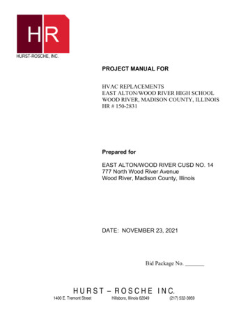
STEP INTO THE FUTURE, STEP INTO THE PAST GRAYS HARBOR HERITAGEWelcome to the Chehalis River Surge PlainTrillium ovatumSitka spruce (Picea sitchensis)Chehalis RiverPreachersSloughlong this trail, catcha glimpse of the past aswell as the future.You’ll travel back 15,000 years to the timewhen ice covered the land, learn how amissed chicken dinner 150 years ago earneda slough its name, and discover theconnection between today’s forestsand tomorrow’s salmon.Area of DetailChehalisRiverBlueSlough0Miles1Parking AreaYou are herePreachersSlough107to MontesanoINTERPRETIVE SIGNS PROJECT LEAD: GINA BLUM. GRAPHIC DESIGN: LUIS PRADOThis project was funded in partby the Aquatic Lands EnhancementAccount (ALEA) program of theDepartment of Natural Resources.Trail construction by the Cedar CreekCorrectional Facility Camp andWashington Conservation Corps crews.Interpretive SignViewpointParking AreaToiletWASHINGTON STATE DEPARTMENT OFNatural ResourcesTrail107to CosmopolisHaveyou seentrilliumsin thespring?
AberdeenAP R O U DHoquiamMontesanoP A R TO FT H EG R A Y SAberdeenH A R B O RCosmopolisExceptionalPlacesH E R I T A G Ehe Departmentof Natural Resourcesaccepts with pridethe charge to safeguardand share with you this specialcomponent of the GraysHarbor Heritage.Outstanding ecosystems includingsalt marshes, mounded prairies,oak woodlandsWe areand ponderosaspared to seepine forests, are the wildernessbud andbeing protectedblossom asstatewide inthe rose.natural areas as—Mrs. Davidthe “last of the(Mary) Byles, GraysHarbor pioneer, thebest.”Montesano Vidette,1898쎰WASHINGTON STATE DEPARTMENT OFNatural ResourcesFor more informationon the ChehalisRiver Surge Plain, contact theDepartment of NaturalResources Central Regionoffice in Chehalis at(360) 748-2383TTY (360) 740-6841or 1-800-527-2387
STEPINTOTHEFUTURE,STEPINTOTHEPAST GRAYSHARBORHERITAGE The channel is wide, the river is narrowBritish ColumbiaCanadaU.S.A.Mt. BakerBellinghamChehalisRiverSan entShorelineSeattleWhen much of the earth’swater was locked up invast ice sheets and glaciers,sea level was loweredseveral hundred feet and thePacific shoreline was some30 to 40 miles west oftoday’s coast.TacomaAberdeenElmaOlympiaSee photorightMt. RainierCentraliaGeologists refer to riverslike the Chehalis as “underfit,”because the river is muchnarrower than its flood plain.They would know that theriver had once been much wider just bylooking at the above photograph.About 15,000 years ago, ice flowedsouth from Canada, between the OlympicMountains and Cascade Range. Riversthat normally flowed into Puget Soundwere blocked. Lakes formed and drainedsouthwest into the Chehalis River.In time, glacial meltwater also flowedinto the Chehalis, temporarily producinga river 20 times larger than yousee it today.You arehereWhatwill the riverlook like inanother15,000years?PUGET LOBE OF THE CORDILLERAN ICE SHEET ILLUSTRATED BY DEE MOLENAARVictoriaRangeCordilleranIce Sheet
S T E PI N TOT H EF U T U R E ,S T E PI N TOT H EPA S T G R AY SH A R B O RH E R I TAG E Union Pacific,Northern Pacific, andMilwaukee Roadengines at their sharedfacility in Hoquiam,he Union Pacific and Milwaukee Road locomotivesfirst thundered along this route on August 15, 1910.Seventy-five years later, the trains were gone.The Milwaukee Road had gone bankrupt and afternumerous slides and washouts, the Union Pacific rerouted its trains tothe more stable tracks on the north side of the river.Today, this trail guides you along theoriginal railroad route, through an area Union Pacific trainof the preserve recoveringcrew and agent inCosmopolis station.its natural splendor.about 19101945.PHOTO COURTESY OF JEFF ASAY South Aberdeen station. 1910 – 1919 Preachers Sloughhad its own stationin the early years beforeWorld War I whenfour passenger trains a dayran between Aberdeenand Centralia. Few peoplehad cars in those daysand trucks were not yetdelivering mail, groceries,or other supplies.By 1921, the automobiledominated personaltransportation.*Note theflag stopat PreachersSlough at11:20 pmCOSMOPOLIS STATION PHOTO AND TIME TABLE COURTESY OF BRIAN FERRISPHOTO COURTESY OF ALBERT FARROW. J. A. PHILLIPS III COLLECTIONWith a shake and a rattleWhatwould it be liketo wait for atrain totake youto town?
STEPINTOTHEFUTURE,STEPINTOTHEPAST GRAYSHARBORHERITAGEThe Chehalis River Surge Plaindo we mean by a surge plain?When tidewater comes up the river, the salt-heavy oceanwater sinks, pushing and lifting the freshwater to the top. The higherfreshwater floods the land and spreads out, running backward intosloughs where it remains until the tide changes course.Saltwater isn’t the slough empty at low tide?Normally, only the upper slough entirely emptiesat low tide. Many sloughs, including this one, receivewater run-off from the surrounding hills andthus are streams as well as sloughs.FreshwaterRiver EstuaryOceanmakes this surge plain special?This is one of the few places left where the mixing of saltwaterand freshwater occurs naturally. The coming together ofsaltwater and freshwater in a natural way creates a flood controlzone for man, a unique plant community and habitatfor fish and other wildlife.Slough atlow tide of –0.3,fall 1999Isthe tidecoming in orgoing outrightnow?
S T E PSalmon FryI N TOT H EF U T U R E ,S T E PI N TOT H EPA S T G R AY SH A R B O RH E R I TAG ELong shadows, cool waters, young salmonetting trees grow tall andthick, drop their leaves,age gracefully, and finally fallinto the slough helpsyoung salmon (fry) survive.The long shadows cool the water,SALMON WEIRThis sketch of Indians fishingand the fallen trees createin the Chehalis River with a weirwas made by a member of thequiet pools where fish canCharles Wilkes expedition in 1842.A weir is a fence usually made ofrest and feed.wood that is placed in a river thatSPECIAL COLLECTIONS DIVISION, UNIVERSITY OF WASHINGTON LIBRARIES. NEGATIVE NO. 3991directs the fish into a gap fittedwith a basket that serves as a penfor easy capture.If youwere a salmonfry, wherewouldyouhide?
S T E PSPRUCE CONE ILLUSTRATION BY JEANNE R. JANISH FROM VASCULAR PLANTS OF THE PACIFIC NORTHWEST. BASKET COURTESY OF LEWIS COUNTY HISTORICAL MUSEUM COLLECTION. SPRUCE PHOTO BY JIM ELLIS / DNRSITKASPRUCERANGEI N TOT H EF U T U R E ,S T E PI N TOT H EPA S T G R AY SH A R B O RH E R I TAG EWhat has a crown but is not a king? What is not married, but has a ring? What has a trunk but never gets around? What makes music but has no sound?Sitka is theworld’s largestspruce. It cangrow up to210 feet andlive tobe 800 yearsold.he answer is the Sitka spruce,Picea sitchensis. You knewthat “tree” was the answer to mostof the questions, but did youknow that parts of violins, guitars,and pianos are made from spruce?It has “perfect pitch.”Spruce is the most abundantspruce,evergreen tree in the surge plain and PiceaSitkasitchensis, haswoody conesis often found sprouting on old logs. 1"–and4"sharp,pricklyneedles.Its wide, flaring baseallows it to thrive in such wetplaces. Trees with broken topsprovide good roost and nest sitesfor eagles, ospreys, heron,Finely split Sitka spruce rootswere used by Lower Chehalis Indiansand other birds.for making woven, water-tightbaskets and rain hats. Designs wereadded by weaving in bleached ordyed grasses.Woulda hat madeof spruce rootskeep youdry?
S T E PT H EF U T U R E ,S T E PI N TOT H EPA S T G R AY SH A R B O RH E R I TAG ERowboat, shoes, saddle, and canoen 1859, the young Methodist-Episcopal minister,J.S. Douglas got around the newly formed Grays Harborcircuit by rowboat, shoes, saddle, and canoe.One fall afternoon, Reverend Douglas set out to row fromthe Byles home (Cosmopolis) to the Scammon family claim (South Montesano).Thoughts of a fine chicken dinner filled his mind until he found himself at the“end of the river.” He had missed the main channel and entered a slough.He was late for his dinner and his bed, but the story so amused thepeople of Grays Harbor that they named the waterwaybefore you “Preachers Slough.” Lower Chehalis Indiansused shovel-nosecanoes for traveling andfishing on the river.The shovel-nose canoehas curved ends that pushswiftly flowing wateraway from the prow.Shovel-nose canoes wererarely taken beyondCosmopolis because theywere considered unsafefor ocean travel.Sea-going canoes needsharp ends to cutthrough rough seas.CANOE FROM SPECIAL COLLECTIONS DIVISION, UNIVERSITY OF WASHINGTON LIBRARIES. NEGATIVE NO. 306North End of SloughI N TOCoulda canoe getthrough todayat lowtide?
fishing on the river. The shovel-nose canoe has curved ends that push swiftly flowing water away from the prow. Shovel-nose canoes were rarely taken beyond Cosmopolis because they were considered unsafe for ocean travel. Sea-going canoes need sharp ends to cut through rough seas. n 1859, the young Methodist-Episcopal minister,