Transcription
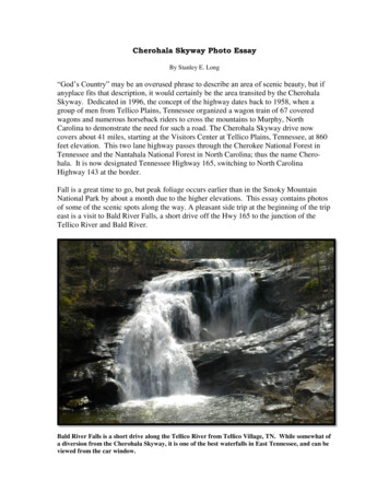
Cherohala Skyway Photo EssayBy Stanley E. Long“God’s Country” may be an overused phrase to describe an area of scenic beauty, but ifanyplace fits that description, it would certainly be the area transited by the CherohalaSkyway. Dedicated in 1996, the concept of the highway dates back to 1958, when agroup of men from Tellico Plains, Tennessee organized a wagon train of 67 coveredwagons and numerous horseback riders to cross the mountains to Murphy, NorthCarolina to demonstrate the need for such a road. The Cherohala Skyway drive nowcovers about 41 miles, starting at the Visitors Center at Tellico Plains, Tennessee, at 860feet elevation. This two lane highway passes through the Cherokee National Forest inTennessee and the Nantahala National Forest in North Carolina; thus the name Cherohala. It is now designated Tennessee Highway 165, switching to North CarolinaHighway 143 at the border.Fall is a great time to go, but peak foliage occurs earlier than in the Smoky MountainNational Park by about a month due to the higher elevations. This essay contains photosof some of the scenic spots along the way. A pleasant side trip at the beginning of the tripeast is a visit to Bald River Falls, a short drive off the Hwy 165 to the junction of theTellico River and Bald River.Bald River Falls is a short drive along the Tellico River from Tellico Village, TN. While somewhat ofa diversion from the Cherohala Skyway, it is one of the best waterfalls in East Tennessee, and can beviewed from the car window.
Back on the Cherohala, there are many overlooks with parking areas, some with picnicareas. For a change of pace, one can visit Indian Boundary Lake, by turning north on theaccess road, just west of the Turkey Creek overlook. It offers camping and picnic areas.Indian Boundary Lake is a short drive off the Skyway to the north, via an access road just west of theTurkey Creek overlook.
The Skyway is a two-lane road following the mountain ridges where possible, with concrete bridgeswhere necessary, such as this one spanning Stratton Meadows.Big Junction overlook, just below the peak elevation reached on the Skyway, appears a bit stark inthe Fall after most leaves have fallen from the trees.
Big Junction Overlook is about two thirds of the way to the east end of the Skyway, andsignals the approach to its peak altitude of 5390 feet at Santeetlah Overlook. Moving oneast from Santeetlah Overlook, an interesting scenic area just below the peak altitude isHooper Bald, at 5290 feet. A hiking trail, about a quarter mile long, is a moderate uphillclimb from the marked trailhead. Views from Hooper Bald make the hike wellworthwhile.The trail to Hooper Bald is a moderately steep climb from the marked trailhead on the Skyway.
Atop Hooper Bald, the terrain flattens out, and is covered with tall grass, bushes, and othervegetation, making it easy walking to the scenic viewpoints.Once there was a Lodge up here, long gone now, called the Hooper Bald Lodge. Therewas an effort to establish a farm for Blue Boar hogs here around 1912. It seems to havefailed and many escaped. Other history of this area and Graham County, North Carolinawhere locals were attacked by bushwhackers during the Civil War years can be found at:http://www.cherohala.com/
Seasonal varieties of foliage and wildflowers may be found on Hooper Bald.
Another typical scenic view from Hooper Bald.Ascending toward the peak altitude of the Cherohala Skyway, the road ahead can be seendisappearing into the trees on the right.
Going east from Hooper Bald, the Skyway descends to Santeetlah Gap, North Carolina at2660 feet elevation. From there, North Carolina Highway 143 leads to Robbinsville,North Carolina. To include some stops to view the scenery, allow about 2.5 hours for aone-way trip on the Skyway. It has been estimated that average traffic on the Skyway is50 cars and 100 motorcycles per day, but most probably occurs in the summer. In winter,it is very desolate and might be closed due to snow and ice.Winter robs the landscape of much of its color, but dramatic features are always present in thesemountains.
east is a visit to Bald River Falls, a short drive off the Hwy 165 to the junction of the Tellico River and Bald River. Bald River Falls is a short drive along the Tellico River from Tellico Village, TN. While somewhat of a diversion from the Cherohala Skyway, it is one of the best waterfalls in Ea