Transcription
GTN seriesGarmin touchscreen avionics are redefining what it means to fly with your fingertips.
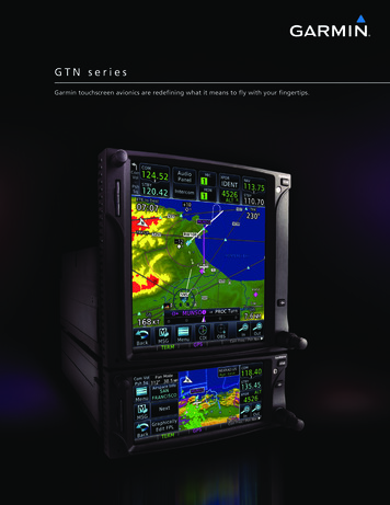
What began back in 1998 with the debut of Garmin’s best-selling GNS 430/530 series of GPS/Nav/Commproducts is now evolved to a whole new level in the GTN series of next-generation avionics.Combining the latest in multi-function display (MFD) features with touchscreen data entry and integrated radiotuning – as well as optional remote transponder and audio panel control – the GTN series offers amazing,yet simple-to-use, technology that once again promises to redirect the course of General Aviation electronics.[ I n t r o d u c i n g t h e n e x t g e n e r a t i o n o f G a r m i nintegrated avionics solutions.]A new graphical user interface with icon-identified onscreen touchkeys makes functions easy to locate and accesson the units’ large, high-resolution TFT displays. Page navigation is more intuitive than ever, with a “shallower” menustructure that greatly simplifies operational sequences. In fact, you’re rarely more than two taps away from all primarypages and functions. You can quickly pan across the map display by simply swiping your finger across the screen.And integration capability for a wide array of avionics and sensors not only simplifies tuning and mode selection –but, in effect, lets pilots utilize the GTN touchscreen as a virtual flight management system.
There’s no place like “Home”.Familiar icon-style graphical interface on the GTN“Home” page makes all operational functions easyto access. A quick tap of the dedicated HOME keyon the bezel takes you back to the desktop from anypage in any data sequence.Land with a plan.Garmin SafeTaxi airport diagrams come pre-installedon all the new GTN models. Plus, on the GTN 750series, you also get preloaded electronic FliteCharts that incorporate over 11,000 approaches for some2,900 U.S. airports.Terrain made plain.With its built-in elevation database, your GarminGTN system provides an extra margin of safety invisualizing terrain/obstacle conflict situations. Foradded protection against hazardous topography,audible terrain alerts and visual pop-ups aresupported with optional TAWS-B functionality.Optional satellite weather.With available XM WX Satellite Weather link, yourGTN unit can access graphical NEXRAD imaging,as well as the latest METARs, TAFs, lightning,and other up-to-the-minute meteorological data.(Requires GDL 69 receiver and XM subscription,sold separately1.)Integrate your approach plate.With optional Garmin ChartView installed on yourGTN 750 series unit2, a graphical view of yourJeppesen-format approach plate can be overlaidon the moving map for geo-referenced guidancethrough the procedure.Easy audio integration.The large-format GTN 750 series can be used asa touchscreen control head to integrate the audioand intercom functions for your aircraft. Garmin’sremote GMA 35 audio system (sold separately) helpsstreamline cockpit communications with record/playback capability for copying clearances.Graphical flight planning.Onscreen flight plan editing makes it easy to addwaypoints or modify your route. And with handy“rubber band” feature, you can even stretch a flightplan leg to detour or amend your routing1XM and the XM logos are trademarks of XM Satellite Radio Inc.2Requires Jeppesen JeppView subscription (sold separately).Get a grip.Raised grips on each side of the bezel, plus a shelfacross the lower edge of the display, serve as anchorpoints to keep your hand securely in position whileentering onscreen data in turbulent air.
Five flavors to choose from.The new GTN multi-capability units are offered in two sizes and a variety ofconfigurations. All GTN 650 series products are contained in a 2.64-inch tallpackage that replicates the in-stack form factor of our popular GNS 430W design.Do more with a shorter stack.In addition to full GPS/Nav/Comm radio managementand graphical MFD-like map navigation, you canoptionally use any GTN touchscreen as a control headfor compatible remote-mount ATC transponders.The larger-format GTN 700 series can also beused to control a remote audio/intercom system.(Note: the glass area on the GTN 650 series is over 50 percent larger than itsGNS 430W series predecessor – while the GTN 750 series screen is nearly 100percent larger than that of the GNS 530W.) The larger GTN 750 series bezelstands 6 inches tall (compared to 4.6 inches for the similar GNS 530); however,to save space in your avionics stack, both the GTN 650 and 750 systems canprovide onscreen code selection and ident for optional remote-mount Garmintransponders (sold separately). In addition, the larger-format GTN 750 screencan optionally be used as your control panel for a new Garmin remote-mountaudio processing unit. The ability to remotely tune both audio/intercom systemand transponder functions from the 750 series means you can position thoseproducts behind your panel – and thus accommodate the larger screen in lesstotal stack height.The optional GMA 35 remote audio control unit (sold separately) works with theGTN 750 series to streamline cockpit communications. Its work-saving featuresinclude a new high-precision automatic squelch function, as well as record/playback capability for help in copying clearances and verifying ATC instructions.Future software upgrades will enable the GMA 35 to incorporate even higherlevels of automation, including digital voice activation and other auto-adjustmentfeatures (requires pre-wired push-to-command button, sold separately).interface; 3) a Direct-To key on the right-side bezel that allows a direct GPScourse to be entered for any selected waypoint; and 4) a set of multi-purposeconcentric tuning knobs, in the lower right corner, that diehard knob-twiddlerscan use in lieu of the units’ touchscreen keypads to enter frequencies, codes ornumerical data. All other GTN system capabilities are accessed directly from thegraphical touchscreen display.Simplicity is paramount in every aspect of the GTN cockpit interface. Thereare only four mechanical controls on the bezel of each panel-mount unit: 1) Avolume/squelch knob located in the upper lefthand corner; 2) a HOME key onThe GTN product line begins with two standalone GPS-only options: The GTN625 and 725. These units both feature a robust 15-channel WAAS-certifiedProduct comparison:GTN 625GTN 635GTN 650GTN 725GTN 750Operational eenTouchscreenUnit size (height)2.64”2.64”2.64”6”6”Display resolution (pixels)600 x 266600 x 266600 x 266600 x 708600 x 70810-watt Comm radioNoYesYesNoYes16-watt Comm radioNoOptionalOptionalNoOptionalVOR/ILS/GS Nav radioNoNoYesNoYesGamma 3 WAAS GPSYesYesYesYesYesHi-res Terrain ionalOptionalPreloaded initial U.S. FliteChartsNot AvailableNot AvailableNot AvailableYesYesJeppesen esYesYesYesYesYesYesYesYesCan control remote audio processorNoNoNoYesYesTraffic System capableYesYesYesYesYesInternal TAWS-B terrain alerting Preloaded U.S. SafeTaxi XM WX Satellite Weather capable1Can control remote transponder231the upper righthand side that returns the display to the icon-style main menu4Requires GDL 69 antenna (sold separately); XM subscription required 2 GTX 32/33 series remote transponders sold separately 3 GMA 35 remote audio panel sold separately 4 Requires GTS 800/820/850 or compatible 3rd party traffic alerting systems
GPS receiver generating five position updates per second. The GPS is TSO C146c certified for primary navigation in allphases of flight – enroute, terminal and approach – with the WAAS technology enabling pilots to fly GPS-guided LPVglidepath instrument approaches down to ILS-comparable minimums (200-ft. decision height, 1/2-mile visibility) wheresuitable airport conditions exist. Using Wide Area Augmentation System (WAAS) vertical approach guidance, IFR pilots areGARMIN GTN SERIESFEATURES AT A GLANCEprovided with more all-weather landing options than ever before.Then, looking beyond standalone GPS capability, Garmin’s new GTN 635 GPS/Comm includes all the navigation featuresof the GTN 625/725, plus a 2280-channel capable VHF communications transceiver (with standard 10-watt or optional16-watt power output). System settings allow users to select between 8.33 and 25 kHz channel spacing. And the familiar“flip-flop” frequency selection scheme allows comm channels to be entered in a standby window, and then activated witha touch of the display. In addition, a handy comm monitor function effectively lets you monitor two separate frequenciesfrom the same radio at once (with the active comm channel always taking priority on incoming calls.)Finally, for the pilot who wants a comprehensive “all-in-one” solution, Garmin offers two choices: The GTN 650 and750 models. These top-of-the-line units include all the GPS/Comm features of the 635, plus a complete package of VHFomni navigation capabilities, including 200-channel VOR/ILS with Localizer and Glideslope receivers. As a useful backupto one’s primary flight instruments, all GTN units feature an electronic CDI display with digital track-error indication. And thedetailed moving map presentation makes for easy viewing of the aircraft’s current position in relation to ground features, Menu-driven graphicalinterface on color LCDtouchscreen display Feature-rich MFD capabilities:moving map, chart display,airways, approaches and more GPS TSO’d to C146c,authorized for Class 1,2,3 (LPV) GPS WAAS-certified toGamma-3 approach capabilitynavaids, flight plan routings, approach procedures and more. WAAS-corrected GPS signalaccuracy to 1 meter RMSFlight planning made simple. Built-in GPS/ILS/VOR/LOC andGlideslope capabilities availableEvery model in the new GTN product family offers graphical flight planning capability: A unique keystroke-saving feature thatallows the pilot to preview a flight plan routing on the map and easily enter new waypoints or modify the sequence with afew taps of the screen. In addition, airway segments can be similarly loaded, selected and displayed for enroute routings.A handy “rubber band” feature lets you grab any flight plan leg on the screen, and then stretch or move it to accommodatea deviation or ATC amendment to your flight plan.By referencing built-in terrain, mapping and obstacles databases, the new GTN units provide a clear MFD-like presentationof the visual landscape beneath your aircraft – including topography features, cities, airports, terminal areas, SUAs, and more.For added safety, there’s a built-in elevation database that provides color-coded terrain page reference and moving mapoverlays to indicate those areas where potential ground proximity hazards may exist. Full Class B TAWS alerting is availableas an option for voice and visual pop-up alerts. And precise course deviation and roll steering outputs can be coupled tomany compatible GA autopilots, enabling virtually all IFR flight procedures to be flown automatically. Then, once you’velanded, geo-referenced SafeTaxi diagrams automatically provide easy directional orientation on nearly 1,000 U.S. airports.Ready, set, grow.Each model in the GTN lineup can support a wide array of optional weather, lightning and traffic system inputs for overlayon the moving map. Optional XM WX Satellite Weather, with graphical NEXRAD, METARs, and more, can be accessedthrough Garmin’s GDL 69 data link receiver (sold separately)1. And you’ll find room on the GTN 750 series’ 6.9-inch diagonaltouchscreens to allow display of your airway charts and approach plates– which come pre-installed on these units in the form of standard GarminFliteCharts . Or, if you prefer the Jeppesen format, you can elect to go withoptional ChartView electronic charts instead2. With ChartView installed,a helpful Garmin geo-referencing feature enables a graphical view of yourapproach plate to be overlaid on the GTN 750 series moving map for realtime visual guidance cues in flying the procedure.Making flight easier by making avionics smarter: That’s what the GTN Graphical flight planning(including airway navigation) VHF comm transceiver: 8.33 or25 kHz channel spacing Comm transmit power: 10 wattstandard, 16 watt optional Extensive optional interfacecapabilities: lightning, weather,traffic, TAWS-B terrain alerting,and more Integrated control/display forremote transponder Integrated control for remoteaudio panel functions(GTN 700 series only) Flight control system interfacefor select autopilots Optional XM WX satelliteweather and XM Radio SafeTaxi airport diagrams Award-winning Garmin productsupport and 2-year warrantytouchscreen series is all about. To find out more, see your Garmin dealer.Or visit our website at www.garmin.com/gtn.Electronic Garmin FliteCharts come pre-loaded on the largerformat GTN 750 series units.12XM subscription required (sold separately). Requires Jeppesen JeppView subscription(sold separately).
GDU 620 Display featuresElectrical 10-40 VDC, reverse polarity protected 55 watts typicalDual 6.5 inch diagonal color LCDRGB backlighting technologyHigh resolution 640x480 VGA (921,600 RGB dots)65,536 simultaneous colorsDirect sunlight readableAuto, manual or lighting bus inputs for dimmingEnvironmental Physical - GDU 620 display 6.7 inches high10.0 inches wide3.25 inches deep6.4 lbs.-20C to 55C operating temp-55C to 85C storage temp2 degrees C per minute temp variation95% at 50C humidityDisplay equipment tested to 55,000 feet max altitudeinternal cooling, external cooling not requiredSystem ArchitectureCertification Criteria Position source: External GPS via RS-232 GPS interface for Garmin 400W series and 500W series Nav radio interfaces: GNS 430W/530W/480 or SL30 8 bi-directional high speed RS-232 ports 2 bi-directional high speed RS-422/485 ports 8 ARINC 429 high/low speed inputs and 4 outputs ADF DC Sin/Cos input Radar interface:- GWX 68 (LRU sold separately)– Optional interface required for G500; standard interfaceincluded for G600- ARINC 708 support is optionally available for select GA radars– Optional interface required for G500 and G600– Check with your Garmin dealer for radar compatibility STC via Approved Model List (AML) for nearly 800 airframes with G600 and nearly600 airframes with G500 G500 is approved for Class 1/Class 2 aircraft (under 6,000 lbs).G600 is approved for Class 1, Class 2 and Class 3 aircraft (including piston andturbine aircraft between 6,000 lbs and 12,500 lbs MTOW). TSO-C2d, TSO-C3d, TSO-C4c, TSO-C6d, TSO-C8d, TSO-C10b, TSO-C34e,TSO-C36e, TSO-C40c, TSO-C41d, TSO-C43c, TSO-C52b, TSO-C63c,TSO-C87, TSO-C113, TSO-C147, TSO-C151b (G600 only)www.garmin.comfeatures and specifications subject to change without notice.Follow the Price,leader.Some listed features will require Version 5.0 software upgrade,available Q4, 2010 Autopilot interfaces– Heading/course error outputs– Analog lateral and vertical deviation outputs– ARINC 429 digital roll steering support– RS-485 digital altitude capture– Analog flight director input– Selected autopilot flight directors GAD 43 adapter (standard on G600; optional on G500) enables AHRS to driveselect autopilot systems. Supports the following gyro emulation:– Approved gyro replacement for: King KI-256 (or equivalent) used on KAP 100, KAP/KFC 150,KAP/KFC 200, KFC 225, and KFC 275 Collins 332D-11T used on select APS-65 installations King KVG 350 used on KFC 250, KFC 300, KFC 325 (non-EFIS)– Evaluating for future approval: Cessna/ARC G519 used on Cessna 300B, 400B and 800B Sperry VG-14A used on SPZ-200, SPZ-500Garmin International, Inc.1200 East 151st Street, Olathe, KS 66062p: 913.397.8200 f: 913.397.8282Garmin (Europe) Ltd., Liberty House, Hounsdown Business Park, Southampton, Hampshire, SO40 9RB, U.K.p: 44.1794.519944 f: 44.1794.519222Garmin Corporation, No. 68, Jangshu 2nd Road, Sijhih, Taipei County, Taiwanp: 886.2.2642.9199 f: 886.2.2642.9099 2011 Garmin Ltd. or its subsidiaries0311M02-60080-00
What began back in 1998 with the debut of Garmin's best-selling GNS 430/530 series of GPS/Nav/Comm products is now evolved to a whole new level in the GTN series of next-generation avionics.