Transcription
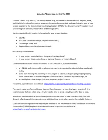
Using the “Grants Map for CFA” for 2022Use the “Grants Map for CFA,” an online, layered map, to answer location questions; pinpoint, draw,and label the location of current or proposed elements of your project; and save/upload a map of yourproject location to the Consolidated Funding Application (CFA) for the Environmental Protection FundGrants Program for Parks, Preservation and Heritage (EPF).Use the map to identify location information for your project location: County,ZIP Code Tabulation Area (ZCTA) and Poverty data,Quadrangle index, andRegional Economic Development Council.Use the map to determine: Is your project located within a designated Heritage Area?Is your project listed on the State or National Register of Historic Places?Use the map to save and upload documents to the CFA such as, but not limited to: a 1:24,000 scale topographic or planimetric map for the project location including quadrangleindex,a site plan showing the proximity of your project to a State park (park polygons) or propertylisted on the State or National Register of Historic Places (National Register listings), oran aerial photo view (imagery) of your proposed project location.The online, layered map is available at: pp.aspx.The map is made up of several layers. Layered files allow users to turn data layers on and off. It isrecommended that you select only a few layers at a time to avoid a lengthy wait for data to load.Most icons on the map allow you to hover your mouse over them to view text describing that tool.Below is a flat image of the map with some additional text to introduce you to the available features.Questions concerning use of the map may be directed to the NYS Office of Parks, Recreation and HistoricPreservation (OPRHP) Regional Grants Administrator for your county as listed athttps://parks.ny.gov/grants/contact.aspx.1
Enter addressSave (PDF) and Print MenuList of layers (turn on or off; includes poverty level)Map LegendDraw tools (add pins/points, lines, shapes, and text to show your project location)Basemap Gallery (use Streets or USA Topo)Zoom inZoom outHome (Default extent)My Location (allow the map to identify your current location; use only if you are physically at the project site)Map scaleLatitude/Longitude coordinates (Activate the sign in the left-hand corner, then click on your project location to lock the coordinates.)Answer Location Questions for your project location in the CFA using the Grants Map for CFAThe instructions below apply to most layers of the map including: County,ZIP Code,ZIP Code Tabulation Area (ZCTA) and Poverty data,Quadrangle index, andRegional Economic Development Council (see the Location tab within the CFA online application).1. Enter the street address, city, and state for your project location into the search box in the upperleft-hand corner of the page. Click the magnifying glass to search or select the appropriate address ifit appears in the search results drop-down box that generates results as you type.If your project location does not have a street address, select the zoom inor zoom outtools (as needed) which will magnify or minimize portions of the map. Then, click and drag the mapto center your project location.2. If your project location has a street address, view the marked location on the map. If correct, clickthe Esc (escape) key or click in the search box to clear the search results box from your screen. If itis incorrect, try zooming in or out to find your project location on the map.3. To identify any of the features listed above (county, ZIP code, etc.), use the layers tool. Click on theList of Layers tool. Select the layer that you wish to view for your project location such asPoverty by ZCTA 2020 ACS (ACS American Community Survey). The boundaries for the ZIP CodeTabulation Areas will then appear on the map. If you do not see anything added, try zooming out to2
see the boundaries. The map legend toolwill show you which layer you are viewing based onthe color of the boundaries or shading. See table below. Close the List of Layers box by clicking the Xin the upper right-hand corner of that box.Map Legend4. Once the boundaries appear, click on the point marking your project location. Note the ZIP CodeTabulation Area (ZCTA) and the Percent Below Poverty Level (%) for your project location andenter that information into the answer for the appropriate question in the CFA. For theEnvironmental Protection Fund (EPF) Grants Program for Parks, Preservation and Heritage,successful applicants are reimbursed for up to 50 percent of their eligible expenditures. Forprojects located in impoverished areas (as defined by 10 percent or more of the population belowpoverty level according to the most recent Census data), the reimbursement can be up to 75percent of the eligible project cost.5. If you selected more than one layer in the List of Layers tool, your results box will have an arrow inthe upper right-hand corner. Click the arrow to view the results of the next feature.6. To view other features, go back to the List of Layers tool. Uncheck the box for the layer(s) youalready viewed. Select another layer that you wish to identify for your project location. Theboundaries of that feature will then be added to the map. Once the boundaries appear, click on the3
point marking your project location to view the data associated with that layer.Is your project located within a designated NYS Heritage Area?The map includes layers for designated urban and regional NYS Heritage Areas with approvedmanagement plans. Projects within the boundaries of the NYS Heritage Areas, along with other criteriaoutlined in the CFA Guidance Document, may be eligible for funding under the Heritage Areas programof the Environmental Protection Fund Grant Program for Parks, Preservation and Heritage (EPF).1. Enter the street address, city, and state for your project location into the search box in the upperleft-hand corner of the page. Click the magnifying glass to search or select the appropriate addressif it appears in the search results drop-down box that generates results as you type.If your project location does not have a street address, select the zoom inor zoom outtools (as needed) which will magnify or minimize portions of the map. Then, click and drag the mapto center your project location.2.If your project location has a street address, view the marked location on the map. If correct, clickthe Esc (escape) key or click in the search box to clear the search results box from your screen. If itis incorrect, try zooming in or out to find your project location on the map.3. To determine if your project location is in a designated Heritage Area, use the layers tool. Click on theList of Layers tool. Select both NYS Urban Heritage Areas and NYS Heritage Areas. Theboundaries will then appear on the map. If you do not see anything added, try zooming in or out tosee the boundaries. Note that some Heritage Areas overlap, so you may wish to view only one type ata time. The Map Legend toolwill show you which type of Heritage Area boundary you areviewing. The NYS Urban Heritage Area boundaries are aqua; the NYS Heritage Area boundaries areblue. Close the List of Layers box by clicking the X in the upper right-hand corner of that box.Once the boundaries appear, click on the point marking your project location. A results box will appearshowing the name of the Heritage Area if your project is located within the boundaries.4
Example of Urban Heritage Area: AlbanyExample of Heritage Area: SusquehannaTo learn more about the Heritage Areas, visit aspx.Written approval/endorsement of the project by the local heritage area management entity, if it isnot the project sponsor, is required with an application for funding under the Heritage Areasprogram of the Environmental Protection Fund Grant Program for Parks, Preservation andHeritage (EPF). The letter should reference the appropriate Heritage Area management plan andrelevant Heritage Area resources and goals. If your project location is within a Heritage Area, toobtain the required endorsement, visit .aspx.Click on the Contact link to obtain a phone number and/or email address for the managemententity for the Heritage Area in which your project is located.Is your project listed on the State or National Register of Historic Places?1. Enter the street address, city, and state for your project location into the search box in the upperleft-hand corner of the page. Click the magnifying glass to search or select the appropriate addressif it appears in the search results drop-down box that generates results as you type.If your project location does not have a street address, select the zoom inor zoom outtools (as needed) which will magnify or minimize portions of the map. Then, click and drag the mapto center your project location.2.If your project location has a street address, view the marked location on the map. If correct, click5
the Esc (escape) key or click in the search box to clear the search results box from your screen. If itis incorrect, try zooming in or out to find your project location on the map.3. To determine if your project location is listed on the State or National Register of Historic Places, usethe layers tool. Click on the List of Layers tool. Select NYS National Register Listings. Theboundaries will then appear on the map. If you do not see anything added, try zooming in or out tosee the boundaries. The NYS National Register Listings are shown on the map in yellow.There are individually listed resources as well as historic districts; some of which overlap. Under theEnvironmental Protection Fund Grants Program for Parks, Preservation and Heritage (EPF), aproperty shall be eligible for grant assistance if, prior to the award of the grant, it is: (a) individuallylisted on the State or National Register of Historic Places; or (b) located within a historic districtwhich is listed on the State or National Register of Historic Places and which is identified in thedistrict nomination form as contributing to the significance of the district.4. If your project is located within the boundaries of a State or National Register listed place, clickwithin the yellow boundary to bring up the results box. The box will show the name of the listedresource (note: it may or may not be the official listed name) along with the National Register ListingNumber. If your project is individually listed, be sure you are viewing the resource name and listingnumber for the individual resource, not the entire historic district. Enter that name and number toanswer the appropriate question in the CFA. Questions about listings on the State or NationalRegister should be directed to the OPRHP National Register Unit at (518) 268-2213.Example of National Register Listing6
5. Once you determine the National Register Listing Number, you can then use that number tofind nomination data, including level of significance, in the Cultural Resource InformationSystem (CRIS) at the following web site: https://cris.parks.ny.gov. At the CRIS Legal Disclaimer,click “I Agree” to proceed. On the next screen, click “Proceed as Guest.” Select the Searchbutton, then enter the criteria to search the database. Use the CRIS On-line Help System forsearch tips at https://cris.parks.ny.gov/CRISHELP/. For questions or technical supportregarding CRIS, please email: CRISHelp@parks.ny.gov.Save/upload a 1:24,000 scale topographic map for the project location including quadrangle index1. From the Basemap Gallery, select USA Topo Maps. It may take a little time for the map totransition to a different base map. Zoom in or out to view the change to topo map as your basemap.2. Enter the street address, city, and state for your project location into the search box in the upperleft-hand corner of the page. Click the magnifying glass to search or select the appropriate addressif it appears in the search results drop-down box that generates results as you type.If your project location does not have a street address, select the zoom inor zoom outtools (as needed) which will magnify or minimize portions of the map. Then, click and drag the mapto center your project location.3.If your project location has a street address, view the marked location on the map. If correct, clickthe Esc (escape) key or click in the search box to clear the search results box from your screen. If it isincorrect, try zooming in or out to find your project location on the map.4. Mark your project location on the map using the Draw tools.For example, click on the point tool. An additional menu of graphics will open showingvarious options to mark your project location.7
Graphics and options available when using Point toolSelect the graphic that you want; you can change the color, size, transparency, and width as shownabove. Then, click on your project location on the map.Your project location is now marked. See the purple circle shown below.Please note that the clear buttonwill delete everything you added to your map,including your project location. Use the Undo buttonwhat you have drawn/marked.if you want to go back and revise5. If your project encompasses more than a particular point, such as the development of a hiking trail,you may show the project location with the various line and shape tools. For example, show acurrent trail with a solid line; show the proposed connection trail with a dotted line. To do so, clickon the Draw tool. Use the line, polyline, or freehand polylinetool.Next select the type of line (dash, dotted, or a combination dash-dot) and color. Click and hold tostart drawing; let go to finish. See the yellow, dotted line connecting to the purple circle below.8
6. You may also add text to your map. Select the draw tool. Click the text tool. Type yourtext into the text box. View the Preview showing the color and size. Adjust the color or size if desired.Then, click on the map where you want to place the text. As you move your mouse across the map, ifthe text tool is activated, your cursor will show the text, “Click to add a point.” If the text tool isinactivated, click on it again. The point you click will become the center point of your text.7. Experiment with the Draw tools as desired to adequately show your project location. Whenfinished, close the Draw tool by clicking the X in the upper right-hand corner of that box.8. Click on the List of Layers tool. Select NYS Quadrangle Index. Click on your project locationto view the name of the quadrangle.9
9. Center your project location on the screen by clicking and dragging the map.10. Click on the Print toolwindow.on the map itself. Do not use the Print menu in your Internet browser11. In the Print options, select Letter ANSI A Portrait from the Layout drop-down box and PDF in theFormat field.12. Enter the following information as shown below in the Map Title field and the Advanced menu:a. Map Title (50 characters): Application #, Question #, Project Nameb. Author (100 characters): Quadrangle Index namec. Copyright (100 characters): Street address, city, state of the project location10
d. Force scale: 24000 (no comma)13. Click the Print button next to the Advanced button.14. A PDF of your map will be generated.If an error message appears instead of your PDF map, clear your browser’s cookies and history. Note:you may lose any graphics or text you added to your map. If you are using Internet Explorer, go to11
Tools Internet Options and in the “General” tab under “Browsing History,” click “delete.” Check the first4 things in the list (“Preserve Favorites ,” Temporary Internet Files, Cookies, and History) and click“delete.” After this is done, click OK, exit out of your browser completely. Open Internet Explorer againand resume saving your map as PDF.15. Once the PDF has been generated, click on it to open it in PDF. View it to ensure that all informationneeded is visible and legible. Click File Save as. Give the map a filename including your CFAapplication #, the question # where the map will be uploaded, and the project name. Save the mapto your electronic files (such as your Desktop, downloads, or wherever you can find it again later).16. Upload the map to the CFA to the application question requesting a 1:24,000 scale map for theEnvironmental Protection Fund Grants Program for Parks, Preservation and Heritage (EPF).Questions concerning use of the map may be directed to the NYS Office of Parks, Recreation and HistoricPreservation (OPRHP) Regional Grants Administrator for your county as listed athttps://parks.ny.gov/grants/contact.aspx.12
Using the "Grants Map for CFA" for 2022. Use the "Grants Map for CFA," an online, layered map, to answer location questions; pinpoint, draw, and label the location of current or proposed elements of your project; and save/upload a map of your project location to the Consolidated Funding Application (CFA) for the Environmental Protection .