Transcription
The Northeast Region
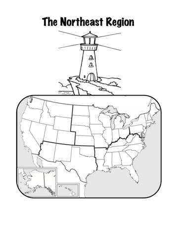
The Northeast RegionLand and Water of the NortheastThe region between the coast of theAtlantic Ocean and the Great Lakes iscalled the Northeast region. The Northeastregion includes eleven states.The Northeast region has broadvalleys, rolling hills, and low mountains.The Appalachian Mountains stretch fromMaine in the Northeast region down toAlabama in the Southeast region. Severaldifferent mountain ranges make up theAppalachian Mountains, including theAllegheny Mountains, the PoconoMountains, the Adirondack Mountains, andthe Catskills.This map shows the eleven states of the Northeastregion.The Appalachian Mountains are oneof the oldest mountain ranges in the world. Although they used to be very tall, they are muchsmaller now. Over time, water, wind, andice have caused the rock of the mountainsto slowly break down. Now the peaks ofthe Appalachian Mountains are smoothand rounded. The longest hiking trail inthe world is the Appalachian Trail. It goesfrom Maine to Georgia, along the spine ofthe mountain range, through more than2,000 miles of valleys, hills, and rivers.The Appalachian Trail is a very popularplace to hike. There are many people whohave hiked the entire trail!The tops of the Appalachian Mountains have beenworn down over many millions of years. created by Jill S. Russ mrsruss.com Page 1
Mount Washington in New Hampshire ispart of the Appalachian Mountain range. At6,288 feet tall, Mount Washington is thehighest peak in the Northeast. MountWashington has some of the world's mostsevere weather. It can snow all year long. Thepeak of Mount Washington is also one of thewindiest places on Earth. The highest windspeed ever recorded there was 231 miles perhour.From the top of Mount Washington, visitorscan see for a hundred miles.The land in the lower part of theNortheast region is good for farming, but theupper part of the region does not have muchfertile land. The soil in that part is very rocky. Long ago, mile-thick sheets of ice calledglaciers covered much of the land. As the glaciers moved across the land, they wore downmountains, carved deep grooves into the coastline, and carried away most of the fertile soil.The melting glaciers formed many lakes. Rocks and sand left behind by glaciers formedislands and capes. Today, jagged cliffs rise up to a hundred feet above the ocean on thenorthern coast.There are many lighthouses along therocky coastline of the Northeast region. Theirlights and foghorns keep ships from crashing intothe rocky shore. The most well known lighthouseis in West Quoddy Head, Maine. West QuoddyHead is the most northeastern point of the UnitedStates.The most important waterway in the regionis the Erie Canal, which connects the Great Lakesto the Atlantic Ocean. A canal is a ditch dugacross land to connect one waterway withanother. The Erie Canal is 363 miles long. Workon the Erie Canal began in 1817 and was created by Jill S. Russ mrsruss.com West Quoddy Head Lighthouse was built in1858.Page 2
finished in 1825. Before the Erie Canal was dug,there was no waterway that crossed theAppalachian Mountains. Moving goods by boat isfaster and cheaper than traveling across land, soit was very difficult and expensive to move goodsfrom the Northeast region to other parts of thecountry without the Erie Canal.There are five Great Lakes: Lake Huron,Lake Ontario, Lake Michigan, Lake Erie,and Lake Superior.Lake Ontario and Lake Erie form part ofthe border of the Northeast region. Lake Ontarioand Lake Erie are two of the five Great Lakes.The Great Lakes are a group of fivefreshwater lakes located in eastern NorthAmerica, on the border between Canada andthe United States. The Great Lakes are solarge they can be seen from the moon! TheGreat Lakes hold one fifth of all the freshwater in the world. As water flows out of LakeErie into Lake Ontario, it flows over NiagaraFalls. Niagara Falls is a 160-foot tall waterfall,the second largest waterfall in the world.The Northeast region has frequent snowstormsin the winter. created by Jill S. Russ mrsruss.com Niagara Falls is on the border betweenCanada and the United States.ClimateThe Northeast region is about halfwaybetween the North Pole and the equator, sothe climate is very different than the climate ofthe Southeast. Winters in the Northeast arelong and cold, with lots of snowstorms. Onekind of snowstorm, called a northeaster, canbring over a foot of snow at one time. Duringthe cold winter months, Lake Erie may freezeover completely. Summers are warm, but shortcompared to those in the Southeast region.Page 3
The climate affects the people, animals, and plants that live there. People have to copewith cold winters. Animals’ food supplies change with the seasons. Squirrels bury nuts to digup in winter. Bears and other animals hibernate. They sleep for up to 100 days. Trees likemaples and oaks drop their leaves each winter to survive the lack of water.Products and Natural ResourcesThe Northeast region has lots of forests, andlogging is an important industry there. Trees are cut downto make houses, paper, furniture, and fuel. Vermont isknown throughout the world for its delicious maple syrupproduced from the sap of the sugar maple tree.Some of the resources of the Northeast come fromunderground, like granite, marble, and coal. Granite andmarble are used to make buildings. Vermont has thelargest granite quarries in the country.The Northeast region has many rivers andMaple syrup is made from the sapwaterfalls. This was very important in the growth of thefrom the sugar maple tree.region because the power produced by the running watermade it possible for people to build mills, or factories. Byusing water driven power, people could run machines and make things much faster thanpeople could at home by hand. Today, factories use other sources of power instead ofwaterpower, but the Northeast region continues to be an important manufacturing center inthe United States. Iron, glass, steel, and many chemicals such as shampoos, paints, andmedicines are manufactured in the Northeast.The soil in parts of the Northeast region is rocky andthe growing season is short, but some fruits and vegetablesare grown in the Northeast. Farmers grow blueberries andpotatoes. Other farms produce chickens, milk from dairycows, and flowers. Cranberries are grown in sandy marshesin the Northeast region. Massachusetts is called theCranberry Capital of America because it produces nearly twomillion barrels of cranberries a year. created by Jill S. Russ mrsruss.com Cranberries grow in damp bogsand swampy areas.Page 4
The Atlantic Ocean is an important resource for fish, lobster,and shellfish. Once these shellfish are caught, they are shipped tofood stores and restaurants all over the country. Fish farming iscalled aquaculture. Fish are raised on farms and are sold for thepurpose of eating. This helps protect the populations of fish that areborn in a natural environment.LandmarksThere is beautiful scenery throughout the Northeast region.Many tourists visit the Northeast region in the fall to see the brightlycolored autumn leaves. These tourists are known as “leaf peepers.”Lobsters are harvestedyear-round in Maine,although most arecaught between lateJune and lateDecember when thelobsters are mostactive.The capital city of the United States is located inthe Northeast region. The capital city is calledWashington, D.C. “D.C.” stands for District of Columbia.The White House, the Capitol, the Supreme Court, andmany other government buildings are located inWashington, D.C.Philadelphia's historical museums welcome peoplefrom around the U.S. each year. You can visitMany tourists visit the NortheastIndependence Hall where the U.S. Constitution wasregion to see the beautiful fallwritten. The Liberty Bell,leaves.Betsy Ross's house andBen Franklin's Post Office are also located in Philadelphia.Visitors to the Northeast can also take a tour of theCrayola Factory. Fascinated visitors can watch swinging vatsof heated wax spin around and dump their colorful contentsinto molds. Just minutes later, 1,200 perfect crayons popout and move along the line toward sorting, boxing, and“Big Blue” is 15 feet long, weighspackaging machines. Tourists can also create art projects 1,500 pounds, and was formed fromwith many of Crayola's products and visit “Big Blue,” the blue crayon scrap "leftolas" mailedin from kids around the country asWorld's Largest Crayon.part of Crayola's 100th birthdaycelebration. created by Jill S. Russ mrsruss.com Page 5
Tourists can also visit Hershey, Pennsylvania, “thesweetest place on Earth.” A hundred years ago, MiltonHershey started a candy business using mass production,a way of making large amounts of the same product. TheHershey bar was America's first mass-produced candybar. Today, Hershey's factory is the largest chocolatefactory in the world. Visitors can design their own candybar, work in the factory packaging Kisses, and ride theroller coasters at Hersheypark. Because of the factory,the whole town smells like chocolate.The Hershey factory is at theintersection of Chocolate Avenueand Cocoa Avenue. Thestreetlights are shaped like Kisses.New York City, New York is the largest city in theUnited States. It is home to over 8 million people. Tomake room for all of these people, New Yorkers beganbuilding skyscrapers. The first skyscrapers were built over a hundred years ago. People liveand work in these very tall buildings. The Empire State Building is New York's most famousskyscraper. This office building has 102 floors. Millions of tourists visit New York every year.They enjoy museums and plays. They visit famous places like the Statue of Liberty.CultureTwo of our most popular sports were invented in the Northeast region. Dr. JamesNaismith in Springfield, Massachusetts, invented basketball in 1891. You can visit theBasketball Hall of Fame there. Four years later, WilliamMorgan invented volleyball in Holyoke, Massachusetts.Amish people still travel by horse andbuggy.A group of people called the Amish live inPennsylvania. Because of their religious beliefs, they donot use electricity or telephones in their homes, or usecars or tractors.Clam chowder, crab cakes, lobster, and otherseafoods are among the Northeast region's most popular foods. Because there are so manydairy farms in this region, people eat a lot of dairy products, too. In fact, Northeasterners eatmore ice cream per person than any other region in the United States. Baked beans, potatochips, and buffalo wings were all invented in the Northeast region. created by Jill S. Russ mrsruss.com Page 6
Thank you!Thank you for downloading this item. If you have questions,concerns, or general comments, please feel free to contactme atjillsruss@gmail.comIf you are pleased with your purchase, please leave feedbackat TpT to let others know how this resource can help them.Thank you again for your purchase! JillView a full listing of my products ssCopyright 2011 by Jill Russ.All rights reserved by the author.Permission to copy for classroom use only.Electronic distribution limited to classroom use only.
large they can be seen from the moon! The Great Lakes hold one fifth of all the fresh water in the world. As water flows out of Lake Erie into Lake Ontario, it flows over Niagara Falls. Niagara Falls is a 160-foot tall waterfall, the second largest waterfall in