Transcription
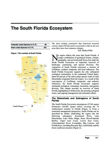
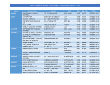
Rough River Lake Wildlife Management Area Index Map37 42'N86 34'W86 32'W86 30'W86 28'W86 26'W86 24'WUV1740261VU629VU86 20'W86 18'W86 16'W86 14'W86 12'W690VU108VU37 40'N105VU86 22'W401UVUV37 38'N2201BRECKINRIDGERough River LakeMap 137 36'N110VURough River DamState Resort ParkAxtelRecreationArea#920UVNorthForkRecreation AreaHARDIN84VULaurelBranchRecreation AreaEverleighRecreationArea259VU737UV37 34'N37 32'N720VUCaveCreekRecreation AreaOHIOPeterCaveRecreation AreaMap 2736UV631VU79VU878VU347VUGRAYSON54VUUV2191736VUA map legend and additional informationare provided on PDF pages thataccompany this map.Publication Date: 3/22/2017UV3155 00.511.522.5Scale 1:145,0003 Mile920VU62 Note to Map UsersMap prepared by Kentucky Department of Fish &Wildlife Resources (KDFWR). Although KDFWRstrives for accuracy, data used to create this mapare from a variety of sources and dates; as such,KDFWR makes no representations regarding theaccuracy or fitness for use of the informationfurnished herein.
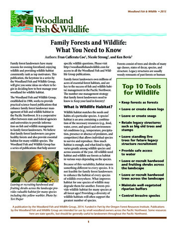
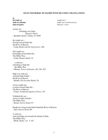
Rough River Lake Wildlife Management Area Map 137 42'N86 30'W86 28'W86 26'W86 24'WVU174086 22'W86 20'W86 18'W86 16'W690UV79VU108UV37 40'N105VUBN ROW NRDTOMUV37 38'N2201ORCave SpringNorthForkRecreation Area401VULaurelBranchRecreation Area110VU259VUEverleighRecreationArea736VUA map legend and additional informationare provided on PDF pages thataccompany this map.Publication Date: 3/22/2017Land Classification from NationalLand Cover Database 2011JM84VUIVER RDHRUGDDR37 36'NRWADRHORKPATU G#Rough River DamState Resort Park-R OC E N TE RV IEWAxtelRecreationArea!RMECACERERSITMPD737VU 00.511.52Scale 1:90,0002.53 MileSee adjoining Map 2Note to Map UsersMap prepared by Kentucky Department of Fish &Wildlife Resources (KDFWR). Although KDFWRstrives for accuracy, data used to create this mapare from a variety of sources and dates; as such,KDFWR makes no representations regarding theaccuracy or fitness for use of the informationfurnished herein.
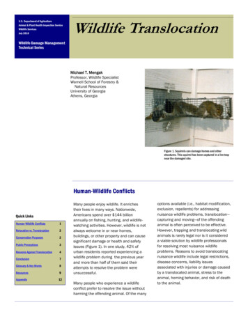
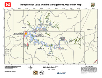
See adjoiningMap 186 28'W86 26'W86 24'WLaurelBranchRecreation Area86 22'W86 20'W86 18'W86 16'W84UVRDEverleighRecreationAreaJM259UVMECERSIT EAM PRDRC110VULEE M IL LER37 36'Nugh River Dam86 30'Wate ResortParkRough River Lake Wildlife Management Area Map 2VALLEYRDVELEIGL720UVIANH RDM E T ER YUCHAMP CERDIND37 34'NCaveCreekRecreation AreaBEASENECA TRESHES R DOR#PINERI DGERD737UVPeterCaveRecreation AreaFO X C L IFF R D!Hanging Rock631VU37 32'N79VUUV219154VUUV37 30'N3155920UVUV280462 A map legend and additional informationare provided on PDF pages thataccompany this map.Publication Date: 3/22/2017Land Classification from NationalLand Cover Database 2011 00.511.52Scale 1:90,0002.53 MileNote to Map UsersMap prepared by Kentucky Department of Fish &Wildlife Resources (KDFWR). Although KDFWRstrives for accuracy, data used to create this mapare from a variety of sources and dates; as such,KDFWR makes no representations regarding theaccuracy or fitness for use of the informationfurnished herein.
Rough River Lake WMA InformationPublic Hunting Area LocationRegional LocatorDirections & Description:WMA consists of shoreline surrounding Rough RiverLake. Access from Caneyville take KY 631; fromOwensboro take US 60 west to Harned and KY 79;from Leitchfield, KY 259; from Big Clifty, KY 720;also access by boat. Rough terrain and high bankslimit access to established areas. Wooded, with a fewcleared fields. Hunters use care: areas surroundingpublic lands are heavily developed.Laurel Branch Campground open year-round; nocamping on the management area. Camping,swimming, overnight accommodations at RoughRiver Dam State Resort Park, (270) 257-2311;fishing and boating in lake.Owned by U.S. Army Corps of Engineers.WMA OverviewLocation & Size: Breckinridge, Grayson & Hardincounties. WMA is 4,180 acres, Rough River Lake is4,856 acres.Contact: (270) 646-5167; COE office (270) 2572061Elevation: minimum 424 feet, maximum 633 feet.Entrance GPS coordinates: Latitude N 37.63605,Longitude W -86.43623Area Habitat: mostly forest: open land 3%, forest85%, wetland 0%, open water 12%Online ResourcesPublic Hunting Area users must abide by theKentucky hunting, trapping, and fishing regulations.It is incumbent on persons using Public HuntingAreas to become familiar with these regulations.Kentucky Department of Fish & Wildlife Resourcesprovides these regulations on our Web site atfw.ky.gov or by calling 1-800-858-1549.
Wildlife Management Area Map Notes & LegendNOTE TO MAP USERS:For most WMA maps the landscape is depicted using a combination of elevation contours, hillshadingand a green tint indicating woodland areas that is derived from satellite imagery. On WMAs that arerelatively small or have a history of surface mining aerial photography is used.WMA Map Legend?!WMA OfficeWMA Boundary]!i!¾Information KioskAerial photographCheck stationOther Public Hunting Areass¾Mobility-impaired Hunting BlindF!È!i!5!