Transcription
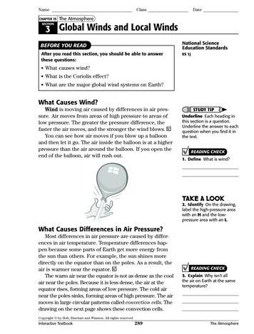
NameCHAPTER 15ClassDateThe AtmosphereSECTION3 Global Winds and Local WindsNational ScienceEducation StandardsBEFORE YOU READAfter you read this section, you should be able to answerthese questions:ES 1j What causes wind? What is the Coriolis effect? What are the major global wind systems on Earth?What Causes Wind?Wind is moving air caused by differences in air pressure. Air moves from areas of high pressure to areas oflow pressure. The greater the pressure difference, thefaster the air moves, and the stronger the wind blows.You can see how air moves if you blow up a balloonand then let it go. The air inside the balloon is at a higherpressure than the air around the balloon. If you open theend of the balloon, air will rush out.STUDY TIPUnderline Each heading inthis section is a question.Underline the answer to eachquestion when you find it inthe text.READING CHECK1. Define What is wind?TAKE A LOOK2. Identify On the drawing,label the high-pressure areawith an H and the lowpressure area with an L.What Causes Differences in Air Pressure?Most differences in air pressure are caused by differences in air temperature. Temperature differences happen because some parts of Earth get more energy fromthe sun than others. For example, the sun shines moredirectly on the equator than on the poles. As a result, theair is warmer near the equator.The warm air near the equator is not as dense as the coolair near the poles. Because it is less dense, the air at theequator rises, forming areas of low pressure. The cold airnear the poles sinks, forming areas of high pressure. The airmoves in large circular patterns called convection cells. Thedrawing on the next page shows these convection cells.READING CHECK3. Explain Why isn’t allthe air on Earth at the sametemperature?Copyright by Holt, Rinehart and Winston. All rights reserved.Interactive Textbook289The Atmosphere
NameSECTION 3ClassDateGlobal Winds and Local Winds continuedConvection CellsLow pressureHigh pressureHigh pressure0 EquatorTAKE A LOOK4. Describe Is air risingor sinking in areas of highpressure?Low pressureHighpressureLow pressure90 S90 NHighpressureWhat Are the Major Global Wind Systems?READING CHECK5. Identify What are thethree main global wind belts?Global winds are large-scale wind systems. There arethree pairs of major global wind systems, or wind belts:trade winds, westerlies, and polar easterlies.Trade winds are wind belts that blow from 30 latitude almost to the equator. They curve to the west asthey blow toward the equator. Westerlies are wind beltsthat are found between 30 and 60 latitude. The westerlies blow toward the poles from west to east. Most ofthe United States is located in the belt of westerly winds.These winds can carry moist air over the United States,producing rain and snow.Polar easterlies are wind belts that extend fromthe poles to 60 latitude. They form as cold, sinking airmoves away from the poles. In the Northern Hemisphere,polar easterlies can carry cold arctic air over the UnitedStates. This can produce snow and freezing weather.Wind beltLocation (latitude)Toward the equatoror toward the poles?Trade winds0 to 30 toward the equatorWesterliesTAKE A LOOK60 to 90 6. Describe Fill in the blanksin the table.The figure on the next page shows the locations ofthese different wind belts. Notice that the winds do notmove in straight lines. The paths of the wind belts arecontrolled by convection cells and by the Earth’s rotation.Copyright by Holt, Rinehart and Winston. All rights reserved.Interactive Textbook290The Atmosphere
NameClassSECTION 3DateGlobal Winds and Local Winds continued90 NSTANDARDS CHECKPolareasterliesES 1j Global patterns ofatmospheric movementinfluence local weather. Oceanshave a major effect on climate,because water in the oceansholds a large amount of heat.ester l ie swind s30 NHorse latitudesW60 NThe trade winds meet andrise near the equator ina region known as thedoldrums. The wind in thedoldrums is very weak.DoldrumsdeTraTradend swiWord Help: majorof great importance orlarge scale30 S Horse latitudesWsteThe region between the tradewinds and the westerlies isknown as the horse latitudes.Here, cool air sinks, creating aregion of high pressure. Thewinds here are very weak.erlies60 SPolareasterliesCool airWarm airWind direction90 S7. Explain Use the map toexplain why surface windsare generally very weaknear the equator.There are three pairs of major global wind belts on Earth: thepolar easterlies, the westerlies, and the trade winds.Why Do Global Winds Curve?Remember that pressure differences can cause air tomove and form winds. If Earth did not rotate, these windswould blow in straight lines. However, because Earth doesrotate, the winds follow curved paths. This deflection, orcurving, of moving objects from a straight path because ofEarth’s rotation is called the Coriolis effect.As Earth rotates, places near the equator travel fasterthan places closer to the poles. This difference in speedcauses the Coriolis effect. Wind moving from the poles tothe equator is deflected to the west. Wind moving fromthe equator to the poles is deflected east.READING CHECK8. Describe How doesEarth’s rotation affect thepaths of global winds?Earth’srotationTAKE A LOOKPath of wind without Coriolis effectApproximate path of wind9. Apply Ideas If air ismoving south fromCalifornia, which way will ittend to curve?The Coriolis effect causes wind and waterto move along curved paths.Copyright by Holt, Rinehart and Winston. All rights reserved.Interactive Textbook291The Atmosphere
NameSECTION 3ClassDateGlobal Winds and Local Winds continuedWhat Are Jet Streams?READING CHECK10. Identify In what twolayers of the atmosphere arethe jet streams found?The polar easterlies, prevailing westerlies, and tradewinds are all winds that we feel on the ground. However,wind systems can also form at high altitude. Jet streamsare narrow belts of very high-speed winds in the uppertroposphere and lower stratosphere. They blow fromwest to east all the way around the Earth.Jet streams can reach speeds of 400 km/h. Pilots flying east over the United States or the Atlantic Ocean tryto catch a jet stream. This wind pushes airplanes along,helping them fly faster and use less fuel. Pilots flyingwest try to avoid the jet streams.The global wind systems are always found in aboutthe same place every day. Unlike these global wind systems, jet streams can be in different places on differentdays. Because jet streams can affect the movements ofstorms, meteorologists try to track the jet streams. Theycan sometimes predict the path of a storm if they knowwhere the jet streams are.0ATH OF*ET 3TREAM-ONDAYTAKE A LOOK11. Infer Why would a pilotflying across North Americatake a different route onTuesday than on Monday?4UESDAY0ATH OF*ET 3TREAMJet streams form between hot and cold air masses. Unlike the otherwind systems, jet streams are found in slightly different places every day.Copyright by Holt, Rinehart and Winston. All rights reserved.Interactive Textbook292The Atmosphere
NameSECTION 3ClassDateGlobal Winds and Local Winds continuedWhat Are Local Winds?Most of the United States is in the belt of prevailingwesterly winds, which move from west to east. However,you’ve probably noticed that the wind in your neighborhood does not always blow from the west to the east.This is because global winds are not the only winds thatblow. Local winds are also important. Local winds arewinds that generally move over short distances and canblow from any direction.Like the other wind systems, local winds are causedby differences in temperature. Many of these temperaturedifferences are caused by geographic features, such asmountains and bodies of water. The figure below showshow water and mountains can affect local winds.12. Compare Describe onedifference between globalwinds and local winds.Say ItDayDuring the day, the ocean heats up moreslowly than the land. A cool sea breezeblows from the ocean to the land.Critical ThinkingThe land heats up quickly. Theair above it warms and rises.This produces an area of lowpressure, so the sea breeze canblow over the land.Share Experiences Haveyou ever been in a verystrong wind? In groups oftwo or three, discuss thestrongest or worst windyou’ve ever been in.NightAt night, the ocean cools off moreslowly than the land. The warmerair over the ocean rises, producingan area of low pressure. The landbreeze can blow over the ocean.The land cools off quickly. The airabove it cools and sinks toward theocean, producing a cool land breeze.TAKE A LOOK13. Identify In the figures,label the high-pressureareas with an H and thelow-pressure areas with an L.MOUNTAIN BREEZES AND VALLEY BREEZESMountain and valley breezes are other examples oflocal winds caused by geography. During the day, the sunwarms the air on mountain slopes. The warm air risesup the mountain slopes, producing a warm valley breeze.At night, the air on the slopes cools. The cool air movesdown the slopes, producing a cool mountain breeze.Copyright by Holt, Rinehart and Winston. All rights reserved.Interactive Textbook293The Atmosphere
NameClassDateSection 3 ReviewNSESES 1jSECTION VOCABULARYCoriolis effect the curving of the path of a moving object from an otherwise straight path dueto the Earth’s rotationjet stream a narrow band of strong winds thatblow in the upper tropospherepolar easterlies prevailing winds that blow fromeast to west between 60 and 90 latitude inboth hemispherestrade winds prevailing winds that blow fromeast to west from 30 latitude to the equator inboth hemisphereswesterlies prevailing winds that blow from westto east between 30 and 60 latitude in bothhemisphereswind the movement of air caused by differencesin air pressure1. Identify The drawing below shows a convection cell. Put arrows on the cell toshow which way the air is moving. Label high pressure areas with an H and lowpressure areas with an L. Label cold air with a C and warm air with a W.2. Identify Which global wind system blows toward the poles between 30 and60 latitude?3. Explain Why does wind tend to blow down from mountains at night?4. Apply Concepts Would there be winds if Earth’s surface were the same tempera-ture everywhere? Explain your answer.Copyright by Holt, Rinehart and Winston. All rights reserved.Interactive Textbook294The Atmosphere
Earth Science Answer Key continued4. Conduction, because heat is transferred4. the pressure produced by the air above a5.6.7.8.9.10.11.12.between two objects that are touching.5. It rises and cools.6. water vapor and carbon dioxide7. L should be on a short-wavelength ray; Hshould be on a long-wavelength ray.surfaceThe air pressure is higher around the treethan around the plane.Air temperature in the atmosphere canincrease or decrease with altitude.about 80 kmPeople and other living things live in thetroposphere. It is where weather happens.It differs from place to place.It absorbs harmful ultraviolet energy.because the temperatures are so high thereLayerHowtemperatureand pressurechange as youmove redecreases.This densestlayer containsmost of theatmosphere.Weather andclouds are eases.Gases arearrangedin layers; itcontains theozone ases.It has the creases.It has aurorasand the . Possible answers: radiation, because theheat moves as waves through the air tothe marshmallow; convection, because hotair carries energy from the fire toward themarshmallow2.Type of energytransferHow energy is transferredRadiationEnergy travels as electromagneticwaves.ConvectionHeat circulates; warm air risesand cool air sinks.ConductionHeat moves from warm objectsto cold objects.3. The heat moves by convection. Warm airrises and cools off. Cool air sinks and thenwarms up. The air is constantly moving.4. Global warming can be caused by thegreenhouse effect. The greenhouse effectcauses Earth’s air temperature to increase.SECTION 3 GLOBAL WINDS AND LOCALWINDS1. moving air caused by differences in air2.Review1. Possible answer: the gases that cover the3.surface of a body in space2. Different layers are made of different gases.Different gases absorb different amounts ofthe sun’s energy.3. The pressure curve should go from theupper left to the lower right of the diagram(decreasing with altitude).4. Gases in the atmosphere absorb energy fromthe sun; when they absorb energy, the airtemperature goes up.4.5.6.SECTION 2 ATMOSPHERIC HEATINGpressureH should be inside the balloon; L should beoutside the balloon.Some parts of Earth get more energy fromthe sun than others.sinkingtrade winds, westerlies, polar easterliesWind beltLocation(latitude)Toward theequator ortoward thepoles?Trade winds0 to 30 toward theequatorWesterlies30 to 60 toward thepolesPolar easterlies60 to 90 toward theequator1. 50%2. Some of it gets absorbed by the atmosphere.7. The trade winds meet and rise here. The airThe rest of it gets scattered and reflected.3. Possible answers: radiation from the sun,conduction from the ground, air convectionis moving up rather than along the surface.8. Earth’s rotation causes surface currents tofollow curved paths.Copyright by Holt, Rinehart and Winston. All rights reserved.Interactive Textbook Answer Key54Earth Science
Earth Science Answer Key continued9. toward the west10. upper troposphere, lower stratosphere11. The jet stream is in different places. The pilot8. Ozone in the stratosphere blocks UV light,which can be harmful to humans.9.would want to catch or avoid the jet stream.12. Global winds blow in one direction, butlocal winds can blow in any direction.13. An L should be on the arrow end of eachwind path; winds blow from H to L.Ozone near thegroundForms naturallyfrom human activityIs not a pollutanta pollutantProtects Earth fromUV raysharmful to living things10. Short-term effects happen quickly and goReview1. Arrows can go clockwise or counterclock-away once the pollution is gone. Long-termeffects develop over a long time and do notgo away easily.11. The electricity to run them must be generated. Many electrical power plants burn fossil fuels to generate electricity. This causespollution in the areas near, and downwindof, the power plants.wise; arrows should point from H to L;sinking air should be labeled “C”; rising airshould be labeled “W.”2. westerlies3. During the day, the mountains warm upand the air above them warms and rises.At night, as the mountains cool off, the aircools down and sinks, producing winds.4. No. Winds are caused by differences in airpressure, which are caused by differences intemperature.Review1. Burning fossil fuels puts primary pollutantsinto the air, causing air pollution. Some ofthese pollutants can combine with water inthe atmosphere to make acid precipitation.Vehicle exhaust combines with sunlight andforms secondary pollutants such as ozone.SECTION 4 AIR POLLUTION1. Ozone forms when other pollutants react2.with one another and with air in the presence of sunlight.2.Ozone in ionsCFCsair conditionersand aerosolspraysholes in theozone layerban onCFCsOzonevehicleexhaustthat reactswith Sulfurdioxideburning offossil fuelsacid rainless fossilfuel usePollutantPrimarypollutant orsecondarypollutant?Natural orcaused bypeople?Car exhaustprimaryhuman-causedDustprimarynatural orhuman-causedOzonesecondaryhuman-causedPaint chemicalsprimaryhuman-causedPollenprimarynatural3. Answers include: soil, water, plants, animals,Sea saltprimarynaturalVolcanic ashprimarynaturalbuildings4. The thinning ozone layer lets harmful UVradiation reach Earth. UV can cause skincancer.3. vehicle exhaust4. motor vehicles5. If there is not enough ventilation, pollutantsChapter 16 UnderstandingWeathercan get trapped inside.6. Answers will vary.7. People burn coal for energy.Pollutants are released.Pollutants combine with water in the air.Acid rain falls in the lake.Fish die.SECTION 1 WATER IN THE AIR1. Weather is a description of what is going onin the atmosphere at a certain time and place.2. condensation3. Warmer air can hold more water vapor.Copyright by Holt, Rinehart and Winston. All rights reserved.Interactive Textbook Answer Key55Earth Science
Name Class Date CHAPTER 15 After you read this section, you should be able to answer these questions: What causes wind? What is the Coriolis effect? What are the major global wind systems on Earth? What Causes Wind? Wind is moving air caused by differences in air pres-sure. Air mo