Transcription
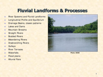
Fluvial Landforms & Processes River Systems and Fluvial LandformsLongitudinal Profile and EquilibriumDrainage Basins, classic patternsLakes and DamsMountain StreamsStraight RiversBraided RiversMeandering RiversAnabranching RiversGulleysRiver TerracesWaterfallsFlood plainsAlluvial FansPhoto: SCGS1
Fluvial Landforms & Processes Rivers are one of the most dominant agents of landscape changeFlowing waters are continually eroding, transporting, and depositingsediments (Fluvial Processes).River based flooding is among one of the most frequent andwidespread natural hazards.2
Longitudinal Profile and Watersheds longitudinal profile: an elevation cross-section of the entirewatershed from the source of flowing water to the mouth of thestream.headwaters: the highest elevation where water collects to form astream network.base level: the lowest elevation that a stream can erode its channel.Local or temporary base levels may be formed by reservoirs orwaterfalls.Headwaters3,000Elevation (feet) UltimateBase level0100River Length (Miles)03
Longitudinal Profile and Watersheds A river’s gradient (slope) is steepest near the headwaters andgentlest near the mouth.As rivers flow from their headwaters to their base level they carvevalleys into the landscape by eroding, transporting, and depositingweathered rocks, soil, and sediment.Headwaters3,000Elevation (feet) moreerosionmoredepositionUltimateBase level0100River Length (Miles)04
Fluvial Equilibrium Stream gradient is related to water velocity and sediment loadA change in any of these affects the other two.base level fluctuations (gradient)precipitation changes (discharge)sediment character
Fluvial EquilibriumRecent uplift in excess of erosionalrates results in a system that is out ofequilibrium.Weathering and erosion dominateheadland areas with removed materialbeing transported to a depositionalbasin.As headlands recede, both erosionaland depositional rates decrease.If the region remains stable foran extended period, equilibrium,where erosional and depositionalrates are equal, might beachieved: Graded Stream.
Fluvial Equilibrium
Longitudinal Profile and Watersheds A watershed or basin is the area of land bound by a drainage divide,where all the water within that area drains downstream from itsheadwaters to a single outflow location.This will include all overland flow, channelized stream flow and anygroundwater contribution8
Longitudinal Profile and Watersheds Drainage divides: high elevation ridges that separate watershedsValleys: section of the basin with a clearly established drainage systemInterfluves: regions separating the valleys, mostly overland flow, noclear drainage pattern established,Nested hierarchy of drainage basins.9
Stream Orders1234312111Headwaters: multiple low-orderstreams near drainage divide455Base level: single outflowand highest order streamStream Order:1st order and 1st order 2nd order2nd order and 2nd order 3rd order3rd order and 3rd order 4th order4th order and 4th order 5th orderAnd so on, 5 and 5 6, 6 and 6 7th order 10
Mississippi River Drainage Basin11
Mississippi River Drainage Basin12
Hudson River BasinHierarchy of drainage basinsUSGS: monitoring of majorrivers and tributaries falls underUSGS jurisdiction.13
14
Structural Relationship Consequent Stream: follow the initial slope of the land. Subsequent streams: exploit zones of structural weaknessAntecedent Streams: predate geologic activity, was able to down cutand keep pace with the uplift Superimposed stream: initial structure controlling the drainagehas been eroded, no resemblance to current surface structure.15
Drainage Patterns16
Fluvial Erosion 3 distinct categories: Rain splash erosion occurs when the impact of a rain droploosens and mobilizes particles. Sheet erosion is a process where particles loosened buy rainsplash erosion are transported by runoff water down the slope ofa surface. Rill erosion occurs when water concentrates during sheeterosion and erodes small rills or gullys into the surface thatchannel flow down slope.www.montcalm.orgCopyright Marli Miller17
Fluvial Erosion Rills & Gullys are the first examples of semi-organized/channelized drainage.When multiple gullys form they produce a disconnected network ofheadwater channels that dissect the hillslope and increase soil erosion.Gullys are most common on disturbed hillslopes (vegetation free).Erosion-extension typically proceeds upslopeErosion-downcutting: steep gradients, increased flow velocities18
Fluvial Erosion Rainfall events, melt-water runoff, orground water percolation.Transported as suspended load,bed load (rolling along thebottom), or bounced by saltation.The accumulation of fluvial erosionand associated processes over alarge area forms pathways forsurface and groundwater flow andcarves v-shaped river valleys thatcontinue to erode, transport, anddeposit weathered sediments acrossthe landscape.Interlocking SpursCopyright Marli Miller19
River Capture or Stream PiracyAbstraction: unequal erosion of a drainage divide, flow transferred to themore energetic side; or Headward Erosion of a tributaryIntercision: intersection ofmeanders or lateral movement oftwo separate streams Anabranching Systems20
Upper CourseInterlocking SpursRapids21
Upper Course: Mountain Streams high-gradient, low-order, sourced from springs, rainfall, or snowmelt. v-shaped valley, bedrock bottom, rapids, waterfalls, narrow flood plain. contain the largest sediment sizes (boulders, cobbles, gravel, etc.) localized pools upstream and or downstream of small elevation drops, thispattern is referred to as a step-pool sequence.22
Upper Course: Waterfalls resistant bedrock, changes in bedrock resistance, fractures or faults.differential weathering creates stair-stepped ledges.less resistant rocks may form pools between waterfalls.faults and fractures provide pathways for the downslope movement ofwater.“knick-point”: slowly migrate upstream.This waterfall was formed by differential weatheringbetween the softer shale and harder more resistantlimestone.Copyright Marli Miller, University of OregonLower White Water Falls inthe Jocassee Gorges areaof South Carolina dropsnearly 200 ft. Here, theToxaway Gneiss forms aresistant bedrock that theLower White Water Riverflows over before draininginto Lake Jocasse.Photo: SCGS23
Upper Course: Waterfalls24
Middle CourseAlluvial FansMeanders25
Middle Course: Alluvial Fans fan-shaped fluvial deposits that accumulate at the base of streamwhere it flows out from a steep gradient and enters into a lowergradient flood plain or valley setting.change in fluid velocity reduces sediment load, forces deposition.common in arid environments with a high sediment load andminimal vegetation.form from a single high-flow event or composite from multipleevents.This alluvial fan is carrying a high sediment load frommaterial weathered from the mountains. The dark linealong the edge of the fan is a road. Because the road isnot buried by recent deposits it suggest that this fan isnot currently as active as it was in the past.Copyright Marli Miller, University of Oregon26
Middle Course: Straight Reach geologically controlled (incised into bedrock, follow geologic structure)not as common as meandering or braided streamsassociated with higher flow velocities and down cutting of the channelprovide insight into bedrock controls or changes in stream gradientStraight reach Straight reach is incised in limestonebedrock Meandering reach is reworkingthrough the flood plainMeandering reachData source: www.dnr.sc.gov/gis.html27
Middle Course: Meandering lower-gradient, sinuous channelsmultiple, individual meander bends that laterally migrating across theflood plain.continuously eroding, transporting, and depositing alluvial sediments.variety of depositional and erosional landform features collectively form the flood plain valley.2006 Aerial imagery: http://www.dnr.sc.gov/GIS/gisdata.html28
Middle Course: Meandering aggrading pointbar deposit on the inside of a meander benderoding cut bank along the outside of the bendas the channel migrates laterally across the flood plain, sediments areeroded from the outer cutbank and deposited on the inner pointbar.when meandering channels cut-off entire meander bends oxbowlakes or in-filled channels are formed.29
Middle Course: Entrenched Meanders Lateral migration is inhibited by geologyDown-cutting becomes the dominant erosion mechanismThe Colorado River flowing through the Grand Canyon in Arizona,provides a classic example of entrenched meanders. Down cutting began as the Colorado Plateau was uplifted 5 myaBelow are the entrenched meanders of the Colorado Riverand to the right is the first geologic interpretation of thenumerous geologic units exposed by the down cutting river.Courtesy USGS Photographic LibraryCopyright Michael Collier30
Lower CourseInterlocking SpursRapids31
Lower Course: Braided sediment load exceeds carrying capacityas carrying capacity decreases, sediment is deposited on channel bedriver forced to carve new path, creating an interwoven network ofchannelsislands between the braided channels are ephemeral and dynamicsediments are continually remobilized, transported and depositedoccur downstream of areas with high sediment loadscomposition varies from silts, sands, and gravelsThis is the braided ResurrectionRiver in Alaska. The sediment loadconsists primarily of silt that hasbeen eroded and weathered fromglacial debris. Braided riverpatterns may also be referred to asanastomosing.Copyright Marli Miller, University of Oregon32
Lower Course: Anabranching multiple channels that weave through semi-permanent alluvialvegetated islands.formed through meander bend cutoffs, channel avulsions(abandonment of an entire channel segment), or mid-channeldeposition and subsequent vegetation.33
Lower Course: Flood Plains region influenced by modern fluvial processesmosaic of landform features: cutbanks,pointbars, natural levees, crevassechannels and crevasse splays, infilledchannels and oxbow lakes, backswamps,and occasionally yazoo tributaries ght 2008 GoogleMississippi River Valley34
Flood PlainsMurray River Catchment, AustraliaCrevasseChannelsMeander-Scrollridges35
Flood Plains: Notes Cutbanks form along the outer convex margin of meander bends. Cutbanks , unlike most floodplainlandforms are actually erosional features formed by the lateral movement of the channel across theflood plain. Flood plain sediments are eroded from the cutbank and deposited on pointbar surfaces.Pointbars are concave, depositional landforms that form opposite of the eroding cutbanks, and theydevelop in concert with the laterally migrating river channel. Pointbars are typically composed ofsands, gravel, silts, and clay deposits, that form arcuate, meander-scroll ridges.Natural levees are depositional landforms formed from the vertical accumulation of sedimentsdeposited during flood events. Natural levees form topographically higher surfaces adjacent to theriver channel, that generally consist of stratified, well-sorted sands, silts, and clays. Natural leveesdeposits are thickest and coarsest close to the channel and they become progressively thinner, andfiner with increasing distance from the channel.Crevasse channels and splays are breaches in the natural levee that result in the fan-shapeddeposition of flood deposits, beyond or over levee deposits. Crevasse channels can produce floodingin backswamp areas, even before the levees are submerged by floodwaters.Oxbow lakes or infilled channels form when a meander bend is cut off from the main river andabandoned in the floodplain. Abandoned meanders can occur in various stages from flooded oxbowlakes to being completely infilled with sediment deposits.Backswamps are typically low-lying areas of the floodplain beyond the natural levee deposits.Backswamps contain the finest-textured flood plain deposits and may even develop organic-rich soilsfrom the forest litter. They often form along the margins or edge of the floodplain, and are usuallyinfluenced by connections to the groundwater.Yazoo tributaries are stream networks that enter the floodplain but the natural levee prevents thestream from flowing into the river. As a result the yazoo tributary flows parallel to the mainstem riverbefore reaching a breach in the levee or occupying the course of an abandoned meander that allowsthe stream to cross the levee deposits and flow into the river.36
Lower Course: River Terraces older remnant flood plain surfaces, higher in elevationthey may occur on one or both sides of the valleyFormation mechanisms vary: Hydraulic or sedimentary changes in the headwaters Valley gradient changed in response to lowered base-level Tectonic and valley upliftStream rejuvenation: a river is said to be rejuvenated when it iseroding the landscape in response to a lowering of its base level.Terrace 1Terrace 2Terrace 3Terrace 4River Channel and Modern Flood Plain37
Lower Course: Delta Coastal Geomorph Controls Discharge Tides Waves SedimentCharacteristics38
Lower Course: Delta39
Longitudinal Profile and Watersheds longitudinal profile: an elevation cross-section of the entire watershed from the source of flowing water to the mouth of the stream. headwaters: the highest elevation where water collects to form a stream network. base level: the lowest elevation that a stream can erode its channel. Loca