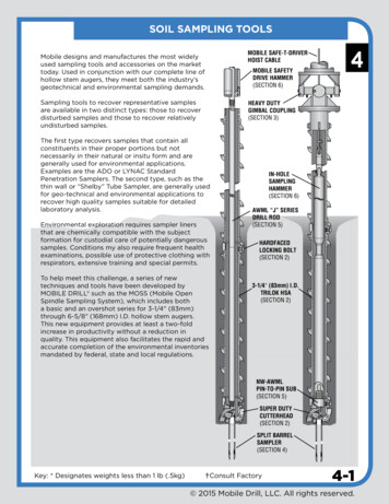
Transcription
Watershed Monitoring ProjectsDRAFTSAMPLING AND ANALYSIS PLANAssessment of Remediation of FluvialTailings Deposits in the UpperArkansas River Basin11-mile Reach Monitoring ProjectLake County, ColoradoPrepared byU.S. Army Corps of EngineersOmaha DistrictOmaha, NebraskaIn Partnership withU.S. Geological SurveyDenver, Colorado
July 20021-2
TABLE OF CONTENTS1.2.INTRODUCTION . 2-51.1PROJECT DESCRIPTION.2-61.2OVERALL PROJECT OBJECTIVES .2-81.3PROJECT SCHEDULE.2-8SAMPLING LOCATIONS AND REQUIREMENTS . 3-12.1SAMPLING LOCATIONS .3-12.1.1Surface Soil/Waste Rock Sampling Locations. 3-12.1.2Soil Boring/Monitoring Well Locations. 3-12.1.3Surface Water/Sediment Sampling Locations. 3-12.2SAMPLING REQUIREMENTS .3-22.2.1Surface and Subsurface Soil Sampling Requirements for Soil Borings. 3-22.2.2Ground Water Sampling Requirements . 3-22.2.3Surface Water and/or Sediment Sampling Requirements . 3-23.FIELD QUALITY CONTROL. 4-13.1FIELD ANALYTICAL PROCEDURES. 11-53.2FIELD QUALITY CONTROL CHECKS . 11-53.3FIELD DATA REDUCTION AND VALIDATION PROCEDURES . 11-53.4FIELD DATA REPORTING. 11-63.5FIELD PERFORMANCE AUDITS. 11-63.6SPECIFIC PROCEDURES . 11-73.6.1Field Measurements . 11-83.6.2Field Corrective Actions. 11-83.74.OFF-SITE ANALYSES . 11-9CHEMICAL DATA QUALITY OBJECTIVES. 11-14.1DATA USES . 11-14.2DATA QUALITY NEEDS. 11-14.3METHOD SPECIFIC DATA QUALITY OBJECTIVES. 11-14.3.1Precision. 11-1i
4.3.24.3.34.3.44.3.54.3.65.Accuracy. 11-1Representativeness. 11-1Completeness. 11-1Comparability . 11-1Sensitivity. 11-1PROJECT ORGANIZATION AND QC RESPONSIBILITY. 11-15.1OVERVIEW. 11-15.2RESPONSIBILITIES . 11-15.3MANAGEMENT RESPONSIBILITIES . 11-15.4QUALITY ASSURANCE RESPONSIBILITIES . 11-15.4.1Project Chemist. 11-15.4.2Project Geologist and/or Project Engineer. 11-15.4.3Project Industrial Hygienist. 11-15.5LABORATORY RESPONSIBILITIES . 11-15.5.1Laboratory Program Manager. 11-15.5.2Laboratory Operations Manager. 11-15.5.3Laboratory Quality Assurance Officer. 11-15.5.4Laboratory Sample Custodian . 11-15.5.5Laboratory Technical Staff. 11-15.6FIELD RESPONSIBILITIES . 11-15.6.1Field Team Leader. 11-15.6.2Drillers . 11-15.6.3Site Safety and Health Officer. 11-16.5.7DATA VALIDATION . 11-15.8REPORTING RESPONSIBILITY. 11-1LABORATORY ANALYTICAL AND PREPERATION PROCEDURES . 11-16.1LABORATORY ANALYTICAL METHODS. 11-16.1.1Volatile Organic Compounds (VOCs). 11-16.1.2Metals . 11-16.1.3Cyanide (CN). 11-16.1.4Water Quality Parameters. 11-16.1.5Soil Analyses (misc). 11-16.1.6Soils Geotechnical Tests . 11-16.2SOLID/SEDIMENT AND LEACHATE SAMPLE PREPERATION PROCEDURES . 11-16.2.1Mine Waste Pile Soils for Leachate Preparation. 11-16.2.2Stream Sediment for Leachate Preparation. 11-16.3ACID BASE ACCOUNTING. 11-16.4GROUND WATER AND SURFACE WATER SAMPLES . 11-1ii
6.5LABORATORY QC SAMPLES. 11-16.5.1Laboratory Blank Samples. 11-16.5.2Surrogate Standards for Organic Analysis . 11-16.5.3Internal Standards . 11-16.5.4Matrix Spike/Matrix Spike Duplicates (MS/MSD) - Organics. 11-16.5.5Matrix Spike/Matrix Spike Duplicates - Inorganics . 11-16.5.6Laboratory Control Samples/Laboratory Control Sample Duplicates . 11-16.6FIELD QC SAMPLES . 11-16.6.1Blank Samples . 11-16.6.2Field Duplicate Samples. 11-16.6.3Matrix Spike/Matrix Spike Duplicate Samples . 11-17.SAMPLE COLLECTION, HANDLING AND DOCUMENTATION PROCEDURES11-17.1SAMPLING IDENTIFICATION SCHEME. 11-17.2SAMPLE CUSTODY. 11-18.PREVENTIVE MAINTENANCE PROCEDURES . 12-18.1FIELD EQUIPMENT. 13-38.2LABORATORY INSTRUMENTS . 13-39.CALIBRATION PROCEDURES AND FREQUENCY. 13-49.1FIELD INSTRUMENTS. 13-49.2LABORATORY INSTRUMENTS . 13-49.2.1Volatile Organic Compounds (VOCs). 13-49.2.2Metals . 13-49.2.3Cyanide . 13-49.2.4Total Dissolved Solids and other Water Quality Parameters/Design Parameters . 13-410.CORRECTIVE ACTION. 14-110.1FIELD PROCEDURES.
Watershed Monitoring Projects DRAFT SAMPLING AND ANALYSIS PLAN Assessment of Remediation of Fluvial Tailings Deposits in the Upper Arkansas River Basin