Transcription
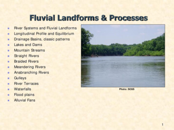
Coastal Landforms and Processes Waves, Tides and Shallow Water ProcessesLittoral ZoneBeaches & Seasonal CyclesBarrier IslandsBeach RidgesHawaiian coastlineSpitsDeltasCoastal CliffsMarine TerracesWave-Cut ScarpsSea Level FluctuationsBarrier Island MigrationCoastal DiversityPhoto source: SCGS1
Factors Influencing Coastal GeomorphologyWinddirect influence:indirect influence:saltation, dunes/blowoutswave generation, ocean circulationsetup - setdownSeiches:lakes, estuaries, small seas, created by changes in barometricpressure, violent storms and tides.Storms:tropical, extratropical (Noreasters), storm surges, winds, wavesBiology:reef builders, filter feeders, grasses/wetlands etc.
Sea Level ChangesSea level changes are easily determined from water level gauges.Few gauges have data extending back 50/100 yearsEustatic: global sea level changes associated with the addition or removal of water(15 cm/century – 23 cm/century)Relative: sea level changes relative to a local datum, incorporates tectonicinfluences
Sea Level Changes
Features and landforms range in size from centimeters to kilometers and areformed or modified over time scales of minutes to millennia.
Wave Formation: Speed, fetch, duration Fully developed sea state Dispersion
Shallow Water Processes: shoaling, refraction, diffraction,reflection, breaking, wave(wind) setup/setdownWave Refraction: changes in the direction of wave propagationdue to along crest variations in wave speedWave Rays: lines drawn perpendicular to the crest of the wavein the direction of wave propagation
Wave RefractionParallel Contours:refraction results in wave raysapproaching normal to shoreline (wave crestsparallel to shoreline (a))(a)Submarine Ridge: focusing of wave energytoward the ridge (b)Submarine Canyon: spreading of wave energythroughout the depression (c)Headland: focusing of wave energy (d)Ebb-Shoal:(b)(d)(c)
Wave Diffraction: bending of wave crests (changes indirection) due to along crest gradients in wave height
Wave BreakingSurf Similarity ParameterDeep WaterWave HeightBeach SlopeDeep WaterWave Length
Nearshore Currents: longshore cross-shore rip currents undertowwave/wind setup
Rip Current bathymetric control hydrodynamic control relation to morphology
Undertow: xshore pressure gradient velocity decreases offshore deposition of material sand bar formation
Tidal forcesTides enhanced during full Moon and new MoonSun-Moon-Earth closely aligned
Influence of Perigee, Apogee, Perihelion andAphelion on the Earth’s TidesStronger for perigee and perihelion
Lunar Cycle
Tides: (diurnal, semi-diurnal, mixed) The periodic change in water level results indifferent parts of the foreshore being exposed towave energy throughout the day. In regions withlarge tidal ranges, the water may rise and fall 10m, and the shoreline may move laterally severalkilometers between high and low water.Different region of the intertidal zone areexposed to erosion and deposition. tidal currents can erode and transport sediment.residual motions can be highly important andspatially asymmetric patterns of ebb and floodstages may cause mass transport of bothwater and sediment. tides cause the draining and filling of tidal bays,an important process related to the cutting andmigration of tidal inlets and the formation offlood- and ebb-tidal shoals in barrier coasts.
Tidal Range ClassificationMicrotidal,Mesotidal,Macrotidal, 2 m.2-4 m. 4 m.
Bay of Fundy, Nova Scotia
Georges Bank, Gulf of Maine
Hayes (1979) classification was based primarily on shores with low to moderatewave power and was intended to be applied to trailing edge, depositionalcoasts. Five shoreline categories were identified based on the relative influenceof tide range versus mean wave height (Nummedal and Fischer 1978; Hayes1979; Davis and Hayes 1984):Tide-dominated (high).Tide-dominated (low).Mixed-energy (tide-dominated).Mixed energy (wave-dominated).Wave-dominated.ShinnecockInlet
Coastal zone: is defined as thetransition zone where the land meetswater, the region that is directlyinfluenced by marine hydrodynamicprocesses. The coastal zone extends offshoreto the continental shelf break andonshore to the first major changein topography above the reach ofmajor storm waves. The CZ is divided into foursubzones:(1) Coast.(2) Shore.(3) Shoreface.(4) Continental shelf.
Coast: a strip of land of indefinite width that extends from the coastline inland asfar as the first major change in topography. Cliffs, frontal dunes, or a line of permanentvegetation usually mark this inland boundary. On barrier coasts, the distinctive back-barrierlagoon/marsh/tidal creek complex isconsidered part of the coast.
The shore: extends from the low-water line to the normal landward limit ofstorm wave effects. divided into two zones: backshore (berm) and foreshore (beach face). Foreshore: low-water line to the limit of wave uprush at high tide. Berm crest: marks the juncture of the foreshore and backshore.
Shoreface: seaward-dipping zone that extends from the low-water lineoffshore to the beginning of the continental shelf (slope transition, depth ofno motion, end of the littoral zone).The shoreface is not found in all coastal zones
The shoreface can be delineated from shore perpendicular profile surveys or frombathymetric charts (if they contain sufficient soundings in shallow water).The shoreface is the zone of most frequent and vigorous sediment transport.
Continental shelf: the shallow seafloor that borders most continents. Extends from the toe of the shoreface to the shelf break where the steeplyinclined continental slope begins. It has been common practice to subdivide the shelf into inner-, mid-, and outerzones, although there are no regularly occurring geomorphic features on mostshelves that suggest a basis for these subdivisions.
Littoral Zone The littoral zone extends inland to the highest water line during stormsand seaward to the furthest area where wave processes stop influencingsediment transport and deposition on the seafloor (shoreface, depth ofno motion).
Littoral Drift all longshore transport within the littoral zone swash transport (beach drift), surfzone transport
Sediment Transport
Beaches Depositional landforms.Most often associated with sand-sized quartz grains, shells or shell hash.Dependent on source of material (volcanic, coral, gravel etc.)Seasonal/storm cycles of evolution, accretion: wider higher during calmsummer months, deflation: narrow, low profile during storm season. Stable, Erosional, Acretional32
Beach Dynamics:Summer: gentler waves move sand shorewardWinter: large storm waves remove sand to offshore bars
Seasonal Cycles: Winter/Storm Profile
Barrier and Spit Formation
Spit Building Fire Island Inlet
Beach Ridges Beach ridges are wave-deposited ridges that form parallel to thecoastline. They are composed of gravel, sands, and shell fragments,and in some cases they may be capped by aeolian sands blownfrom the beach.Source: Google 200839
Deltas Coastal Geomorph Controls Discharge Tides Waves SedimentCharacteristics40
Deltas41
Differential Erosion: Sea Arch, Stacks44
Marine Terraces
Coastal Diversity: Long IslandAmero-Trailing Edge CoastSouth Shore Significant Wave Conditions: H 1.5 m, T 8 secMicro-Meso Tidal EnvironmentsTide DominatedCliff or BluffCoastTide Dominated &RiverineGravel, sandGravel2mWave DominatedSandBarrier IslandMixed Energy
Atlantic North: Glaciated Coast Coasts are deeply indented andbordered by numerous rockyislands. The embayments usually havestraight sides and deep water as aresult of erosion by the glaciers. Uplifted terraces as a result ofisostatic rebound. Moraines, drumlins, and sanddunes, the result of reworkingoutwash deposits, are commonfeatures. Glaciated coasts in North Americaextend from the New York Cityarea north to the Canadian Arctic,on the west coast, from Seattle,Washington, north to the AleutianIslands, and in the Great Lakes.(Shepard 1982).
Atlantic Central & South: Barrier and Drowned Valley Coasts The Atlantic coastal plain, featuresalmost continuous barriersinterrupted by inlets and by largeembayments with dendritic drownedriver valleys, the largest beingDelaware and Chesapeake Bays. Extensive wetlands and marshesmark much of the coast, wheresediment and marsh vegetation havepartly filled the lagoons behind thebarriers. The best exhibit of cuspateforelands in the world extends fromthe mouth of Chesapeake Bay toCape Romain, South Carolina. Extensive development along thesoutheast coast of Florida. From Miami through easternLouisiana, coastal characteristicsalternate between swampy coast andwhite sand barriers.
North American has over 10,000 km of barriers, 1/3 of all barrier coast of the world.
The Atlantic & Gulf of Mexico: Coral and Mangrove Coasts The barrier islands change fromquartz sand south of Miami tocarbonate-dominated sand,eventually transforming into coralkeys and mangrove forest. Live reefs along the east andsouth side of the keys and theshallows of Florida Bay studdedwith mangrove islands extendingnorth and west into the Evergladesand the Ten Thousand Islandsarea that comprises the lowerFlorida Gulf of Mexico coast.
Gulf of Mexico: Wetland Mangrove, and Barrier CoastsSand supply is limited (limestonebedrock), so barriers are presentonly where there is a significantsource, otherwise the coast ischaracterized by swamps.Enclosed bays usually have anabundance of mangrove islandsand the topography is low withmany lakes and marshes.Low wave energy environment.The Mississippi River has built aseries of deltas into the Gulf ofMexico, the most recent BalizeDelta (bird foot) has an averageage of 1500 years.Most of the greater Mississippidelta is marshland and mud flats,with numerous shallow lakes andintertwining channels.
Gulf of Mexico West: Barrier Coast Barrier Island become thedominant coastal feature from theMississippi Delta through Texas. Some of the longest barrierislands in the world are locatedalong the Texas coast. PadreIsland and Mustang Island,combined, extend for 208 km andfeature extensive dune fieldsbehind the broad beaches. Thedunes rarely rise more than 10 min height, and many marshy washover deltas have extended into thelarge lagoons behind the barriers. Extreme wind driven circulation. Alarge part of Laguna Madre is onlyinundated during flood periods orwhen the wind blows water fromCorpus Christi Bay onto the flats.
Pacific: Sea Cliffs and Terraced Coasts Low sea cliffs bordered byterraces and a few coastal plainsand deltas compose the coasts ofsouthern California. Sea cliffs in this area are activelyeroding, particularly in areas wherethey have been cut into alluvium. Despite the presence of a seriesof regional mountain ranges thatcut across the coast, the ruggedcentral and northern Californiacoast is one of the straightest inthe world. This area has high cliffswith raised marine terraces. A fewbroad river valleys interrupt themountainous coast.
Pacific: Sea Cliffs and Terraced Coasts North of Cape Mendocino, thecoast trends almost directly north,through Oregon and Washington,to the Strait of Juan de Fuca.Barriers or spits have formed atriver mouths. Because of the North PacificOcean harsh wave climate, all ofthe major cities in Oregon andWashington were founded insheltered water bodies.
The Bering & Chukchi Seas: Arctic Coastal Plains & Barriers The volcanic Aleutian Mountainsextend some 2200 km (1370miles) forming the border betweenthe Pacific Ocean and the BeringSea. Beyond the Alaska Peninsulaand bordering the Bering Sea,extensive coastal plains are foundwith numerous lakes andmeandering streams. The Yukon River has formed alarge delta with many old lobesthat form a vast plain connectingsmall, elevated tracts. In the north permafrost melting insummer creates thaw lakes. North of Kotzebue Sound, barriersand cuspate forelands border thecoast.
The Beaufort Sea: Deltaic Coast East of Point Barrow, the coast isdominated by river deltas. Rivers draining the Brooks Rangeand the northern CanadianRockies, built these deltas eventhough the rivers flow only a shortperiod each year. Where the deltas are not activelybuilding into the sea, extensivebarrier islands can be found.
About 20 percent of the 1,650 kmof shore on the main islands issandy beach. The Hawaiian Islands are the topsof volcanic mountains rising abovethe ocean floor about five kmbelow the water surface. Thesevolcanoes formed over a localizedhot spot of magma generation. As the older volcanoes formedgreat shields and died, themovement of the ocean floor andcrust moved them to thenorthwest. A higher percentage ofsand shores are found on the olderislands. The sand on the beachesprimarily calcareous and ofbiologic origin, where river outletsare present, smaller pocketbeaches of volcanic sand may befound.
They have a combined surfacearea of 245,300 km2 (94,700miles2), making them the largestfreshwater body in the world. The lakes range in elevation fromabout 183 m for Lake Superior(International Great Lakes Datum1985) to about 75 m for LakeOntario, with the largest drop inelevation, 51 m between LakesErie and Ontario at Niagara Falls(CCEE 1994). Geologically, the Great Lakes arerelatively young, having beenformed by glacial action during thePleistocene period. The shores of the Great Lakesand other freshwater lakes in theUnited States and throughout theworld are as diverse as the oceanshores, featuring high and lowerosive and non-erosive cliffs andbluffs, low plains, sandy beaches,dunes, barriers and wetlands.
Wind direct influence: saltation, dunes/blowouts indirect influence: wave generation, ocean circulation setup - setdown Seiches: lakes, estuaries, small seas, created by changes in barometric pressure, violent storms and tides. Storms: tropica