Transcription
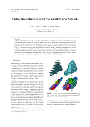
Surface Reconstruction from Unorganized PointsHugues HoppeTony DeRoseTom DuchampyzJohn McDonaldWerner StuetzlezUniversity of WashingtonSeattle, WA 98195AbstractWe describe and demonstrate an algorithm that takes as input anIR3 on or near an ununorganized set of points x1 : : : xnknown manifold M, and produces as output a simplicial surface thatapproximates M. Neither the topology, the presence of boundaries,nor the geometry of M are assumed to be known in advance — allare inferred automatically from the data. This problem naturallyarises in a variety of practical situations such as range scanningan object from multiple view points, recovery of biological shapesfrom two-dimensional slices, and interactive surface sketching.fcomplex objects, including those as simple as a coffee cupwith a handle (a surface of genus 1), or the object depictedin Figure 1a (a surface of genus 3), cannot be accomplishedby either of these methods. To adequately scan these objects,multiple view points must be used. Merging the data generatedfrom multiple view points to reconstruct a polyhedral surfacerepresentation is a non-trivial task [11].g CR Categories and Subject Descriptors: I.3.5 [ComputerGraphics]: Computational Geometry and Object Modeling.Additional Keywords: Geometric Modeling, Surface Fitting,Three-Dimensional Shape Recovery, Range Data Analysis.1 IntroductionBroadly speaking, the class of problems we are interested in canbe stated as follows: Given partial information of an unknownsurface, construct, to the extent possible, a compact representationof the surface. Reconstruction problems of this sort occur in diversescientific and engineering application domains, including: Surfaces from range data: The data produced by laser rangescanning systems is typically a rectangular grid of distancesfrom the sensor to the object being scanned. If the sensorand object are fixed, only objects that are “point viewable”can be fully digitized. More sophisticated systems, such asthose produced by Cyberware Laboratory, Inc., are capableof digitizing cylindrical objects by rotating either the sensoror the object. However, the scanning of topologically moreDepartment of Computer Science and Engineering, FR-35y Department of Mathematics, GN-50z Department of Statistics, GN-22This work was supported in part by Bellcore, the Xerox Corporation,IBM, Hewlett-Packard, the Digital Equipment Corporation, the Department of Energy under grant DE-FG06-85-ER25006, the National Library ofMedicine under grant NIH LM-04174, and the National Science Foundationunder grants CCR-8957323 and DMS-9103002. Surfaces from contours: In many medical studies it is common to slice biological specimens into thin layers with a microtome. The outlines of the structures of interest are thendigitized to create a stack of contours. The problem is toreconstruct the three-dimensional structures from the stacksof two-dimensional contours. Although this problem has received a good deal of attention, there remain severe limitationswith current methods. Perhaps foremost among these is thedifficulty of automatically dealing with branching structures[3, 12].Interactive surface sketching: A number of researchers, including Schneider [21] and Eisenman [6], have investigatedthe creation of curves in IR2 by tracing the path of a stylus ormouse as the user sketches the desired shape. Sachs et al. [19]describe a system, called 3-Draw, that permits the creation offree-form curves in IR3 by recording the motion of a stylus fittedwith a Polhemus sensor. This can be extended to the design offree-form surfaces by ignoring the order in which positions arerecorded, allowing the user to move the stylus arbitrarily backand forth over the surface. The problem is then to constructa surface representation faithful to the unordered collection ofpoints.Reconstruction algorithms addressing these problems have typically been crafted on a case by case basis to exploit partial structurein the data. For instance, algorithms solving the surface from contours problem make heavy use of the fact that data are organized intocontours (i.e., closed polygons), and that the contours lie in parallel planes. Similarly, specialized algorithms to reconstruct surfacesfrom multiple view point range data might exploit the adjacencyrelationship of the data points within each view.In contrast, our approach is to pose a unifying general problemthat does not assume any structure on the data points. This approachhas both theoretical and practical merit. On the theoretical side,abstracting to a general problem often sheds light on the truly criticalaspects of the problem. On the practical side, a single algorithmthat solves the general problem can be used to solve any specificproblem instance.
1.1 TerminologyBy a surface we mean a “compact, connected, orientable twodimensional manifold, possibly with boundary, embedded in IR3 ”(cf. O’Neill [17]). A surface without boundary will be called aclosed surface. If we want to emphasize that a surface possesses anon-empty boundary, we will call it a bordered surface. A piecewiselinear surface with triangular faces will be referred to as a simplicialsurface. We use x to denote the Euclidean length of a vector x,and we use d(X Y) to denote the Hausdorff distance between thesets of points X and Y (the Hausdorff distance is simply the distancebetween the two closest points of X and Y).Let X x1 : : : xn be sampled data points on or near anunknown surface M (see Figure 1b). To capture the error in mostX issampling processes, we assume that each of the points xiof the form xi yi ei , where yi M is a point on the unknownIR3 is an error vector. We call such a sample Xsurface and ei -noisy if ei for all i. A value for can be estimated in mostapplications (e.g., the accuracy of the laser scanner). Features of Mthat are small compared to will obviously not be recoverable.It is also impossible to recover features of M in regions whereinsufficient sampling has occurred. In particular, if M is a borderedsurface, such as a sphere with a disc removed, it is impossible todistinguish holes in the sample from holes in the surface. To capturethe intuitive notion of sampling density we need to make anotherM be a (noiseless) sample of adefinition: Let Y y1 : : : ynsurface M. The sample Y is said to be -dense if any sphere withradius and center in M contains at least one sample point in Y. A -noisy sample x1 : : : xnIR3 of a surface M is said to be Mdense if there exists a noiseless -dense sample y1 : : : yn , i 1 : : : n.such that xi yi ei , eikkfg2k k ff22ggk k fg1.2 Problem StatementThe goal of surface reconstruction is to determine a surface M0 (seeFigure 2f) that approximates an unknown surface M (Figure 1a),using a sample X (Figure 1b) and information about the samplingprocess, for example, bounds on the noise magnitude and thesampling density .We are currently working to develop conditions on the originalsurface M and the sample X that are sufficient to allow M to bereliably reconstructed. As that work is still preliminary, we are unable to give guarantees for the algorithm presented here. However,the algorithm has worked well in practice where the results can becompared to the original surface (see Section 4).2 Related Work2.1 Surface Reconstructionf It requires only an unorganized collection of points on or nearthe surface. No additional information is needed (such asnormal information used by Muraki’s method).Unlike the parametric methods mentioned above, it can reconstruct surfaces of arbitrary topology.Unlike previously suggested implicit methods, it deals withboundaries in a natural way, and it does not generate spurioussurface components not supported by the data.2.2 Surface Reconstruction vs Function ReconstructionTerms like “surface fitting” appear in reference to two distinctclasses of problems: surface reconstruction and function reconstruction. The goal of surface reconstruction was stated earlier. Thegoal of function reconstruction may be stated as follows: Given asurface M, a set xi M , and a set yi IR , determine a functionIR, such that f (xi ) yi .f :MThe domain surface M is most commonly a plane embedded inIR3 , in which case the problem is a standard one considered inapproximation theory. The case where M is a sphere has also beenextensively treated (cf. [7]). Some recent work under the titlesurfaces on surfaces addresses the case when M is a general curvedsurface such as the skin of an airplane [16].Function reconstruction methods can be used for surface reconstruction in simple, special cases, where the surface to be reconstructed is, roughly speaking, the graph of a function over a knownsurface M. It is important to recognize just how limited these special cases are — for example, not every surface homeomorphic to asphere is the graph of a function over the sphere. The point we wantto make is that function reconstruction must not be misconstrued tosolve the general surface reconstruction problem.!f 2 g f 2 g3 A Description of the AlgorithmSurface reconstruction methods can be classified according to theway in which they represent the reconstructed surface.Implicit reconstruction methods attempt to find a smooth funcIR such that x1 : : : xn is close to the zero settion f : IR3Z(f ). They differ with respect to the form of f and the measure ofcloseness. Pratt [18] and Taubin [25] minimize the sum of squaredHausdorff distances from the data points to the zero set of a polynomial in three variables. Muraki [15] takes f to be a linear combination of three-dimensional Gaussian kernels with different meansand spreads. His goodness-of-fit function measures how close thevalues of f at the data points are to zero, and how well the unitnormals to the zero set of f match the normals estimated from thedata. Moore and Warren [13] fit a piecewise polynomial recursivelyand then enforce continuity using a technique they call free formblending.!In contrast to implicit reconstruction techniques, parametric reconstruction techniques represent the reconstructed surface as atopological embedding f ( ) of a 2-dimensional parameter domaininto IR3 . Previous work has concentrated on domain spaces withsimple topology, i.e. the plane and the sphere. Hastie and Stuetzle [9] and Vemuri [26, 27] discuss reconstruction of surfaces by atopological embedding f ( ) of a planar region into IR3 . Schudyand Ballard [22, 23] and Brinkley [4] consider the reconstructionof surfaces that are slightly deformed spheres, and thus chooseto be a sphere. Sclaroff and Pentland [24] describe a hybrid implicit/parametric method for fitting a deformed sphere to a set ofpoints using deformations of a superquadric.Compared to the techniques mentioned above, our method hasseveral advantages:g3.1 OverviewOur surface reconstruction algorithm consists of two stages. In theIR, where D IR3 is a regionfirst stage we define a function f : Dnear the data, such that f estimates the signed geometric distance tothe unknown surface M. The zero set Z(f ) is our estimate for M.In the second stage we use a contouring algorithm to approximateZ(f ) by a simplicial surface.Although the unsigned distance function f would be easier toestimate, zero is not a regular value of f . Zero is, however, a regularvalue of f , and the implicit function theorem thus guarantees thatour approximation Z(f ) is a manifold.The key ingredient to defining the signed distance function is toassociate an oriented plane with each of the data points. These!jjjj
tangent planes serve as local linear approximations to the surface.Although the construction of the tangent planes is relatively simple,the selection of their orientations so as to define a globally consistentorientation for the surface is one of the major obstacles facing thealgorithm. As indicated in Figure 2b, the tangent planes do notdirectly define the surface, since their union may have a complicatednon-manifold structure. Rather, we use the tangent planes to definethe signed distance function to the surface. An example of thesimplicial surface obtained by contouring the zero set of the signeddistance function is shown in Figure 2e. The next several sectionsdevelop in more detail the successive steps of the algorithm.3.2 Tangent Plane EstimationThe first step toward defining a signed distance function is to compute an oriented tangent plane for each data point. The tangent planeTp (xi) associated with the data point xi is represented as a point oi , i . The signedcalled the center, together with a unit normal vector nIR3 to Tp (xi ) is defined to bedistance of an arbitrary point p i . The center and normal for Tp (xi) are deterdisti (p) (p oi ) nmined by gathering together the k points of X nearest to xi ; this setis denoted by Nbhd (xi ) and is called the k-neighborhood of xi . (Wecurrently assume k to be a user-specified parameter, although in Section 5 we propose a method for determining k automatically.) Thecenter and unit normal are computed so that the plane disti (p) 0is the least squares best fitting plane to Nbhd (xi ). That is, the cen iter oi is taken to be the centroid of Nbhd (xi ), and the normal n i,is determined using principal component analysis. To compute nthe covariance matrix of Nbhd (xi ) is formed. This is the symmetric3 3 positive semi-definite matrix2; f CV X(yy2Nbhd (xi ); oi )(yg; oi );3.3 Consistent Tangent Plane Orientation2Suppose two data points xi xj X are geometrically close. Ideally,when the data is dense and the surface is smooth, the corresponding i ) and Tp (xj) (oj n j ) are nearlytangent planes Tp (xi ) (oi n i n j1. If the planes are consistently oriented,parallel, i.e. n i n j 1; otherwise, either n i or n j should be flipped.then nThe difficulty in finding a consistent global orientation is that thiscondition should hold between all pairs of “sufficiently close” datapoints.We can model the problem as graph optimization. The graphcon
The point we want to make is that function reconstruction must not be misconstrued to solve the general surface reconstruction problem. 3 A Description of the Algorithm 3.1 Overview Our surface reconstruction algorithm consists of two stages. In the firststagewedefineafunctionf: D near the data, such that IR,whereD IR 3 isaregion f estimates the signed geometric distance to the unknown .
