Transcription
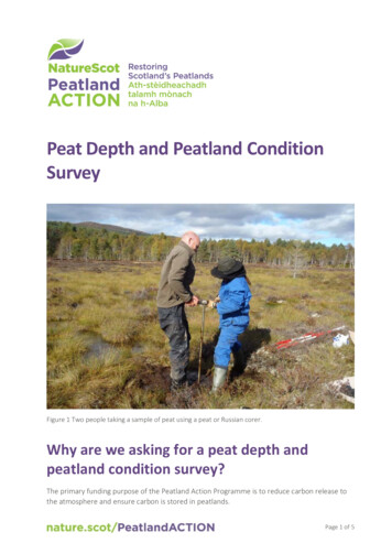
Peat Depth and Peatland ConditionSurveyFigure 1 Two people taking a sample of peat using a peat or Russian corer.Why are we asking for a peat depth andpeatland condition survey?The primary funding purpose of the Peatland Action Programme is to reduce carbon release tothe atmosphere and ensure carbon is stored in peatlands.Page 1 of 5
Current mapping of peat depths in most areas is neither accurate nor detailed. Collecting dataon peat depth will allow better quantification of the stored peat resource where restoration istaking place. This in turn enables a partial estimation of the carbon stored on the site.Collecting information on the peatland condition will facilitate an estimation of the greenhousegas emissions from the peatland.What will we do with the information?The peat depth and peatland condition survey will be made publicly available to further ourunderstanding of the total peat and carbon resource and greenhouse gas fluxes.Forms and guidanceAll the forms and guidance documents referenced below can be found on the Peatland ACTION –Peat depth and survey guidance webpage.Survey methodYou will need;1.A peat probe with sufficient length of rods to measure the full depth of the peat.NatureScot may be able to loan peat probes upon request, but they are also available tobuy on the internet as ‘peat probes’. Bamboo canes are unsuitable as they will snap andcould cause injury;2.A handheld GPS device. This is used to record the sampling locations;3.Tape measure;4.Gloves with latex palm;5.Pre-printed field forms (Excel recording template);6.Peatland Condition Assessment guide;7.Weather writer;8.Digital camera.Before you start1.The survey should cover the area(s) within the overall project area (including anypreviously restored areas) identified as containing ‘carbon and peatland Classes 1-5’ usingthe Carbon and peatland map 2016 and associated guidance;2.Mark 100 m x 100 m grid on a map and aerial photograph;Page 2 of 5
3.Check that there are no overhead cables or underground utilities that run across thepeatland.4.Plan your route to enable the crossing of ditches and other obstacles;5.Measure the length of an individual rod to speed up the measuring process;6.You may wish to mark graduations on the rods with tape;7.Carry out a risk assessment. HSE offers useful guidance on working around overhead lines.Important Note: Do not probe peat near or under electricity powers lines and beware of verywet ground.Peat depth can be measured relatively easily using a narrow rod pushed into the peat at regularintervals across the site. The depth to which the rod sinks reflects the local peat depth.The survey is completed on an approximate 100 m by 100 m grid basis, which providesinformation on peat depth variability and identifies areas where areas of deeper peat arepresent. The peat survey should cover the whole area that is restored. Where precise probelocations are considered unrepresentative of the adjacent surrounding habitat, they should bebetter relocated and geo-referenced to ensure more representative samples.At each intersection of the 100 m x 100 m grid, record the position by noting the grid referenceusing the GPS. Record the peatland condition category (at each grid intersection) using thePeatland Condition Assessment guidance. Take 1 representative photograph of each sample area(please also record metadata for each photograph including 6-figure grid reference, image filename, description and date). Push the first rod into the peat. Initially this may be difficult to doparticularly if the peat is dry and vegetation thick. Add further rods as necessary. When the rodcomes to a halt or you feel additional resistance or note a change in progress of the rods, markor note the surface level on the rod and remove the rods, unscrewing each section as it isremoved. This reduces the risk of bending the rods.Points to note1.The exact position of the probing point is more important than sticking to the 100 m x 100m grid positions. Ground conditions or access may restrict access to the exact grid point.An accurate national grid reference of the actual probing point is our main aim.2.Select a probing location that is representative of the immediate area. Tussocks andhummocks raise the surface level above the actual peat level. The peat surface nearditches is often lower due to erosion and degradation of the peat.3.Peat deposits are a mantle which sits above rock, gravel or clays. When the rod reachesthe mineral substrate below it will either stop suddenly, or get more increasingly moredifficult to push in. When extracting the final rod check the tip – if it has sand or clay at thepoint, this indicates it has reached the substrate below the peat.Page 3 of 5
4.Tree roots, wood and trees buried in the moss may affect the depth at which the probestops. Where the peat depth unexpectedly appears shallower it is advisable to probe ametre or so away from the original probe point.5.Peat probes should never be used near power lines or buried utilities, and you should notwalk around with an extended peat probe.6.Take care when pulling out the probe, particularly if the depth is greater than three metresand always attach the T- piece handle when pulling. Refer to HSE Manual lifting guidanceand follow the manufacturer’s instructions.Information that should be recorded on thesurveyThe following information must be provided on the peat depth and peatland condition surveyExcel template.1.Information about the survey-Data supplier organisation and contactSNH Grant number (50xxxx)Site nameDate(s) of survey (e.g. 10/08/2019 to 11/08/2019)Total number of points surveyedGeneral weather conditions at time of surveyModel of GPS device and accuracy during the surveyFor each peat depth sampling point, provide the following information in the peat depth andpeatland condition survey Excel template. You can also submit the data in GIS shapefile format,provided that all of the attributes that are required in the Excel template are included.2.Information about each probe point-Grid reference (in British National Grid) or 6-8 figure eastings and northings, in BritishNational Grid.Date of sampling (day/month/year) Please also include time of sampling when usingelectronic recording systemPeat depth (in cm, to the nearest centimetre)*Sample point identification reference (e.g. A1, A2 )Peatland condition categoryPhotographs taken at each probe point**Comment or observation (if appropriate)* This level of detail is required due to the various thresholds (30 cm, 50 cm) forcategorising depth.Page 4 of 5
** The photographs are useful for long term monitoring purposes. A photo should betaken at each probe point for sites 30 ha. For sites larger than 30 ha, a representativesample of photos from 10% of the probe points will suffice.To assess the peatland condition category at each probe point, simply chose one of fivecondition categories. The Peatland Condition Assessment Guide includes descriptions andphotographs of four categories. And, as we do a lot of restoration work on previously afforestedsites, we are asking that you record forested, or previously afforested sites, as such. The fivecategories are: Near natural, modified, drained, actively eroding and forested/previouslyafforested.Maps of areas surveyed and peat depth and peatland condition can also be produced. Pleaseinclude appropriate copyright to take into account the basemaps used. Any additionalinformation collected during the survey is also welcome.All the forms and guidance documents can be found on the project webpage.Please submit peat depth survey data electronically to: peatlandactionpeatdepth@nature.scotusing our recording templates.Page 5 of 5
- Date(s) of survey (e.g. 10/08/2019 to 11/08/2019) - Total number of points surveyed - General weather conditions at time of survey - Model of GPS device and accuracy during the survey . For each peat depth sampling point, provide the following information in the peat depth and peatland condition survey Excel template.