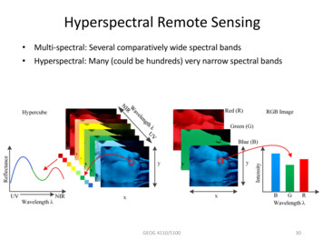
Transcription
Modern Applied ScienceVol. 2, No. 6UPM-APSB AISA Airborne Hyperspectral Technologyfor Managing Mangrove Forest in MalaysiaKamaruzaman JusoffYale University, Centre for Earth Observation (CEO)Environmental Science Centre, 21 Sachem St, New Haven CT 06511, USATel: 203-676-7761E-mail: jusoff.kamaruzaman@yale.eduThe research is financed by Universiti Putra Malaysia and Aeroscan Precision (M) Sdn Bhd (Sponsoring information)AbstractMangrove forests are one of the most productive and bio-diverse wetlands environments on earth. In Malaysia, ForestryDepartment of Peninsular Malaysia (FDPM) has always been fully committed to the implementation of the sustainableforest management practices and in line with current concerns such as climate change, conservation of biodiversity andTsunami, have brought about a heightened expectation on the political, socio-economic, ecological and environmentalwell-being of the country. Thus, managing mangrove forests is very challenging to the department and a precisegeospatial database is urgently required. The objectives of this paper are to assess the capability of UPM-APSB’s AISAairborne hyperspectral imaging sensor for developing a geospatial database through an individual mangrove speciesmapping and to determine the wavelength regions that define the inherent spectral characteristics amongst mangrovespecies. A total of nine groups of mangrove species spectral separability were identified in Port Klang, Selangor namelyLumnitzera littorea, Rhizophora mucronata, R. stylosa, Sonneratia alba, Avicennia officials, R. apiculata, Bruguieraparviflora, B. gymnorhiza, B. cylindrical and S. caseolaris. The species were easily identified and separated in the NIRrange (700 nm to 900 nm) with the following spectral values namely (a) 1,750-6,000:B. cylindrical, (b) 2,000-7,750: B.gymnorhiza, (c) 1,875-8,250: B. parviflora, (d) 1,875-5,500 :A. officials, (e) 1,625-6,250 :S. caseolaris, (f) 1,875-5,250:S. alba, (g) 1,750-7,500: R. apiculata, (h) 2,000-8,000: R. stylosa, (i) 2,200-7,000: R. mucronata. Results of this studyindicated that the mangrove species could only be identified at the near infrared (NIR) wavelength (700 nm to 900 nm)and not in the visible (VIS) spectrum. With such a capability, the sensor should be in a position to provide a geospatialdatabase of the Malaysian mangroves for Tsunami management and other purposes of interests. Future management ofmangrove forests in P.Malaysia should then adopt an integrated approach by further refining the current managementand incorporating latest findings and updated latest geospatial information through more vigorous airbornehyperspectral data acquisition on mangrove forest. With the future geospatial database developed from the sensor, theNational Forestry Policy and other policies related to mangrove forests management can be revised from time to time tomatch latest prevailing conditions and requirement. The future success in developing a mangrove geospatial databaseusing UPM-APSB’s AISA data by FDPM will in fact contribute to the sustainability of the wetlands in Malaysia whichis crucial to the survival and future health of our Mother Earth.Keywords: Mangrove, Airborne sensing, Hyperspectral, Mapping, Management, Tsunami1. IntroductionMangrove forests are one of the most productive and bio-diverse wetlands environments on earth. The importance ofmangrove forests in providing invaluable goods and services both in economics and environmental terms are wellunderstood and documented (Dato’ Hj. Dahlan, 2007). In Peninsular Malaysia, mangrove forests forms one of the majorwetland types which have been identified as one of the key life support systems on earth. Mangroves in P. Malaysia arefound mainly on the sheltered west coast that borders the Straits of Melaka in the states of Kedah, Perak, Selangor andJohor. Major near-shore islands, including the Kelang islands in Selangor and Pulau Kukup in Johore are alsopredominantly colonized by mangroves. Small patches of mangrove forests occur along the rocky shores and theyinclude those found in Pulau Langkawi, Kedah; in Pulau Pangkor, Perak; and in Port Dickson, Negeri Sembilan. In thesouth, mangroves are found in the estuaries of Sungai Pulai and Sg. Johor which drain into the straits of Johor, and theremaining mangroves are found along the straits of Johore. On the east coast, mangrove forests are mostly confined to90
Modern Applied ScienceNovember, 2008sheltered estuaries of the Kelantan Delta and Tok Bali, Kelantan (Kasawani et. al., 2007), Kemaman river inTerengganu, Bebar in Pahang. The total area of mangrove forests in Peninsular Malaysia at the end of 2006 is estimatedto be 107,802 ha of which 82,091 ha has been gazetted as Permanent Reserved Forests (PRFs). Perak has the largestmangrove reserves, followed by Johore and Selangor. Mangrove reserves of Matang (Perak), South Johor (Johor) andKelang (Selangor), together constitute 74 percent of the mangrove forest reserves. The importance of managingmangrove forests using hierarchy analysis goes beyond their status as the habitat of many endangered flora and faunaspecies (Nur Ilayana and Kamaruzaman, 2007). They are a valuable natural resource with distinctive diversity, highintrinsic natural productivity and unique habitat value. Mangrove forests provide invaluable goods and services bothin economics and environmental terms. Apart from the production of poles, charcoal and fuel wood, the mangroveecosystem supports a wide range of functions such as coastline protection, assimilation of waste, source of food, shelterand sanctuary for fauna, spawning and breeding ground for marine life and also recently proven as a barrier tosignificantly reduce the height and force of the waves of the tsunami. The mangrove forests can be an idyllic retreatfor nature and wildlife lovers, photographers, bird-watchers or anyone who wants to relax and appreciate the beauty ofthe mangrove environment and its diverse flora and fauna. The meandering rivers and rivulets add to the peacefulenvironment especially to those escaping the tension of city life. Fireflies found at river estuaries have been a majorecotourism attraction, such as in Kampong Kuantan, Selangor (Wan Faridah et. al., 2007); Kampong Yakyoh,Trengganu; Kelantan Delta, Tumpat; Sungai Lebam, Johor; and Kuala Linggi, Negeri Sembilan/Melaka. Traditionally,the coastal communities living within or at the fringes of the mangrove forests have been dependent on the mangroveforests for their livelihood. Mangrove forests are a major source of fishery resources. The mudflats are habitats forvarious types of shellfish, where many species of fish, prawns and other marine fauna spawn and feed. Localcommunities have been relying on the mangrove forests for consumable plants and medicinal herbs (Amjad andkamaruzaman, 2007). Yet, these unique coastal tropical forests environment are among the most threatened habitats inthe world, for instance the degradation of Indus Delta mangroves in Pakistan (Amjad et. al., 2007).Mangroves act as “bio-shield” as they act as a barrier to the coastal waves, but the impact caused by the tsunamis wasso devastating that it has resulted in the destruction of many mangrove trees along the southeastern coast lines. Anobvious environmental impact of the Tsunami is the physical damage to the mangroves that has resulted from wavesand backwash. The deposit of silt may lead to the clogging of pores of the aerial roots of mangroves and cause totaldestruction of the plant species. The degree and extent of damage of the mangrove is not known. Their loss cancertainly prove to be disastrous in terms of coastline ecosystem functions. An integrated comparative approach tomangrove vegetation mapping using advanced remote sensing and GIS technologies has been well reported by manyresearchers Aschbacher et. al., 1995; Amjad et. al., 2007; and Kasawani et.al., 2007). For Tsunami-effected areas, as allother disaster-effected areas, utilization of hyperspectral sensing data, in particular airborne hyperpsectral imagingtechnology can offer a real-time synoptic view for quick detection, quantification and monitoring in real-time. Moreover,remote sensing and GIS can be used to model the impact of disasters such as Tsunami. The benefits of spectral imaginghave been addressed in university research, especially in Malaysia for more than four years. Several airborneinstruments especially UPM-APSB’s AISA sensor have been available for applications development and studies(Kamaruzaman, 2006); in addition, new airborne instruments with refined capabilities have been recently flown or arenearing completion. The use of airborne instruments is a natural way to develop algorithms and techniques. Typically,the image resolution is determined by instrument design and aircraft altitude and this can be varied to understandresolution impacts on phenomenological processes. In addition, aircraft systems allow opportunistic collections becauseof their scheduling flexibility with respect to weather. Satellite systems, on the other hand, permit broader, recurringviews to address larger scale and regional issues. Until now, there have been no space-based hyperspectral instrumentsto provide this option. Hyperspectral imaging is the simultaneous collection of images covering many narrow,contiguous wavelength bands. From each pixel in the image spectral responses that are indicative of what material isexposed on the Earth’s surface can be extracted. Absorption features in these spectra are determined by chemicalcomposition and physical structure and as such can be used to identify a wide range of materials. Subtle variations incomposition or structure lead to shifts in position and shape of absorption features which allows the differentiation ofmany similar substances and the depth of absorption features that provide the measure of abundance. Thesecapabilities are what make airborne hyperspectral imaging such a powerful tool in remote sensing (Kamaruzaman,2006).The objective of this paper is therefore to demonstrate the capabilities and usefulness of UPM-APSB’s AISAairborne hyperspectral imaging technique for future geospatial database development towards sustainable managementof the mangroves with a specific individual species mapping case study in Port Klang, Selangor, Malaysia.2. Methodology2.1 Description of the study areaFew area of interest (AOIs) was selected in this study covering Sabah and Peninsular Malaysia. However, in this paperonly Port Klang mangrove forests located in Klang River and Northport of Klang in the state of Selangor have beenselected (Fig.1). The geographical position of Port Klang mangrove forest is located at latitudes 2º59'24" N-2º59'12" N91
Vol. 2, No. 6Modern Applied Scienceand longitudes 101º22'36" E-101º23'12" E. The study area comprises of four major families of mangrove species(Avicenniaceae, Rhizophoraceae, Bruguiera and Sonneratiaceae). A total of 19 samples of mangrove trees wererandomly selected for this study. The mangrove species that were randomly selected in the area includes Rhizophoramucronata (Bakau Kurap), Rhizophora stylosa (Bakau), Rhizophora apiculata (Bakau Minyak). Bruguiera parviflora(Lenggadai), Bruguiera gymnorhiza (Tumu), Bruguiera cylindrical (Bakau Putih), Sonneratiacaseolaris(Berembang ), Sonneratia alba (Perepat ), Lumnitzera littorea (Teruntum Merah ) and Avicennia officials (Api-apiLudat). Fig. 1 A map of Peninsular Malaysia showing the location of study site (in red circle) 2.2 Systems overview of UPM-APSB’s AISA hyperspectral airborne sensing technologyUPM-APSB’S AISA airborne hyperspectral system is a commercial hyperspectral sensor product that wasmanufactured by Finnish Company SPECIM, Spectral Imaging Ltd. and is operated by Forest Geospatial Information &Survey Lab (FGISL)/Aeroscan Precision (M) Sdn. Bhd. in Lebuh Silikon, Universiti Putra Malaysia to acquirehyperspectral imaging data from the sky about mangrove canopy (Fig.2). This sensor is a small, lightweight (15 kg)portable instrument and easy to handle. Recent enhancements to the hardware and software of the Caligeo system haveproduced a significant reduction in the integration time, which has improved its overall spectral and spatial capabilities.The swath width of the aircraft is 360 m with a 10% overlap and Field of View (FOV) that will be flying in cross trackwith the direction of 20º and can produce a spatial ground resolution from 1 km altitude approximately 1 m at a flightspeed of 120 knots (60 m/s). UPM-APSB’s AISA airborne hyperspectral sensor is capable of collecting data within aspectral range between 430 to 1,100 nm and have 286 spectral channels. Current operational collection configurationsrange from 10 to 70 spectral bands depending on the aircraft speed, altitude and mission goals. Fig. 2 A complete UPM-APSB’s AISA airborne hyperspectral sensor system The UPM-APSB’s AISA sensor system also incorporates the Fiber Optic Downwelling Irradiance System (FODIS).The FODIS allows for the concurrent measurement of downwelling and upwelling radiance by the UPM-APSB’s AISAsensor head. A diffuse collector installed on the top of the plane is connected to the UPM-APSB’s AISA head via fiberoptic cable and collects downwelling irradiance in the same bandwidth configurations as the areas being imaged. Thecalibration of the FODIS coupled with the UPM-APSB’s AISA sensor allows for the calculation of apparent at-platformreflectance.2.3 Data pre and advance processingIn order to provide accurate location of the remotely sensed data, an Inertial Navigation System (INS) and DifferentialGPS (DGPS) are integrated into the UPM-APSB’s AISA sensor suite. The INS and UPM-APSB’s AISA data streamsare combined in the collection computer to provide frame by frame geo-referencing of the imagery. Pitch, roll, and yaware encoded with the DGPS information to provide accurate locations of areas of interest on the ground. TheUPM-APSB’s AISA pre-processing software (CaliGeo) provides for the automatic geometric correction, rectification,mosaicking, and calculation of radiance or apparent at-platform reflectance (FODIS ratio). The program uses the DGPSand attitude information from the INS to perform the geometric, geo-referencing and mosaicking operations. Automatedbatch processing provides for rapid turnaround times for data delivery. To ensure the accurate measurement andcalculation of radiance and "reflectance", the UPM-APSB’s AISA system is frequently calibrated using’s own NISTtraceable integrating sphere. The generated calibration files were used by the CaliGeo software to output images ineither radiance (mW/cm2/sr/nm/ms – times a scaling factor) or apparent reflectance. Hyperspectral imaging data istypically formatted into cubes in which the base of the cube is a two-dimensional spatial image of the observed scene ata given wavelength and the height of the cube is built up of many 2-D image layers, each from a different spectralchannel. The resultant cubes are typically very large.ENVI 4.0 which combines a complete image-processing package with the most advanced yet easy-to-use spectral toolswas used for the digital image analysis in this study. This powerful amalgam creates a complete data analysis andvisualization environment perfect for today’s advanced earth science courses. The ease of use, ability to handle airbornehyperspectral data, powerful algorithms and flexible parameters make ENVI 4.0 an excellent choice for hyperspectralanalysis. In the data analysis process, factors such as the sensor and attitude alignments, accuracies of the attitudemeasurement system, DGPS, ground control points and the digital elevation model were all required to be taken intoconsideration. This ancillary data, in combination with the hyperspectral data (in the 400 nm to 1,100 nm band range,depending on the application requirements), adds up to more than two gigabytes of data amassed during eachoperational remote sensing flight. In addition, multiple flights are routinely required to scan the entire area under study,further compounding the volume of data until complete images, sometimes as large as 50 gigabytes, are created. ENVI'sspectral analysis tools, for example the spectral angle mapper and unmixing algorithms, to analyse the data includes anextensive spectral library for mangrove forest species, as well as masking and classification routines which complementENVI's many other image processing and data analysis routines were fully utilized in this study. Additional mangrove92
Modern Applied ScienceNovember, 2008forest analysis algorithms were developed using IDL and incorporated with ENVI.3. Results and discussion3.1 Development of spectral signatures for individual mangrove forest species mapping and identificationThe spectral libraries for 19 randomly selected mangrove trees at Port Klang using analysis image from UPM-APSB’sAISA airborne sensor through ENVI software were obtained. From the 19 samples that were randomly selected, a totalof nine mangrove species was identified and mapped using the UPM-APSB’s AISA sensor (Fig.3). Through the visible(VIS) light region (650 - 680 nm), mangrove forest tree is very low in spectral reflectance, with the exception of smallrise in the green. The spectral profiles for nine species from 19 selected trees showed different spectral profile andwavelength absorption because each tree species emitted or radiated varying VIS and Near Infrared (NIR) light atdifferent wavelength. In this study, different spectral patterns were observed from different mangrove species. Theseresults encourage us to further study mangrove areas in the tropics as well as to acquire information on local distributionof different mangrove species for sustainable management and conservation in preparation for the second Tsunami, ifany. Fig. 3 shows that the wavelength range between 450-700 nm absorbed sunlight below 2,000 values and allemittance at this range did not show much different from each other. In the wavelength range of 700 nm to 800 nm,there are increased of spectral value from 1,750 to nearly 8,500. The spectral profiles of 19 selected trees wereinseparable within this wavelength range because the intensity of solar energy reflected by trees is in dependent on thechlorophyll’s ability to absorb the red and blue energy and the spongy layer to reflect the NIR energy. Perhaps, this isthe reason why multi-spectral based satellites do not have such capability to identify individual mangrove tree species(Kamaruzaman, 2006; Kamaruzaman and Kasawani, 2007; and Kasawani et. al., 2007). Fig. 3 The spectral signature profile of nine mangrove species developed using the UPM-APSB’s AISA sensor The trend of spectral profiles for nine species from 19-selected trees depends on the color of the canopy. The arisingcolors from the image showed that those four major colors can be separated in order to determine the dominant familiesof mangroves species (Fig.3). From the range of major colours (red, orange, green and yellow) they could then bedistributed into nine different colours with various bands. The red canopy from AISA image can only be divided intoone type of red (dark red) while the orange canopy could extract three more types of orange (dark orange, intermediateorange and light orange).A total of 10 of tree species were registered in the NIR region approximately at 700-900 nmwavelengths. These include families from Rhizophora, Bruguiera, Avicennia and Sonneratia. As displayed in on theelectromagnetic spectrum that covers approximately 450-700 nm, the spectral profiles look similar. However, in theNIR region of the spectrum, the spectral profiles can be separated from each other.3.2 Limited geospatial information in managing mangrove forests of MalaysiaThere is limited geospatial information or documentation on mangrove degradation and destruction along the Malaysiancoastlines. Similarly, many statements have been made about the impact on biological diversity loss, but there are lacksof scientific data or evidence especially real-time remote sensing geospatial database to support these statements.However, shrinking mangrove areas resulting from developmental decisions of the past, as well as signs of strain on theremaining mangroves provides evidence of threat to this ecosystem (Kasawani et. al., 2007). Being a fragile ecosystem,mangroves tend to fluctuate as a result of slight changes in the natural environment. Rapid development has led toclearing of mangrove areas to make way for urban and infrastructure development, beach resorts and aquaculture ponds.Industries and factories situated near the rivers and streams might discharge their effluent into the water systems,polluting and choking the riverine habitat, and eventually adversely affecting the aquatic biodiversity. The disruption ofmangrove functions as part of our wetland ecosystem has a high cost: economically, socially and ecologically. Thedisturbance of their natural balance can destroy critical gene pools required for medical and agricultural purposes,affecting their ability to protect the coastline naturally and ruined their use for educational and recreational purposes.Constant sedimentation has endangered a variety of fishes and other marine species, particularly the corals.Destruction of mangroves led to a dramatic loss to the commercial and recreational fishing industry, coastal erosion, andendangered many floral and faunal species.The mangrove ecosystem is a sensitive ecosystem that has continued to be affected by the rapid economic growth of thecountry. The familiar development-environment frictions have always been a major concern. Population pressures andthe increasing demand for land continue to pose threat to the coastal and marine resources. Mangrove forests have beenthe most vulnerable, under severe pressure and the first to be cleared when the need for land arises. There have beenperceptions that mangrove areas are considered wasteland, thus, converting mangrove to other uses will fetch a higherfinancial returns. To many, mangroves are considered an eyesore that need to be cleared, while to some, mangroves area waterfront that need to be developed, failing to recognize the essential functions of mangroves in maintaining thecoastal ecosystem. Another issue is jurisdiction between federal and state government. Matters related to land use andnatural resources remains within the exclusive jurisdiction of the state. The vast natural resources sectors such asforests, fishery, wildlife, mining and agriculture are under different agencies/authority with separate sets of regulatory93
Vol. 2, No. 6Modern Applied Sciencelaws, which at times creates overlaps in prescriptive and enforcement jurisdiction. The establishment of the NationalForestry Council has successfully tackled this issue at policy level, and the various committees formed at the federaland state levels has helped to further improve towards conservation, sustainable use, management and development ofthe mangroves. Public awareness regarding mangroves and their conservation is on the rise. But some still do notappreciate the role of mangroves to the environment and quality of life. Despite the many benefits and functions,mangroves is seen not much more than timber, charcoal and woodchips, Indirect benefits offered by mangroves areeasily forgotten and set aside when quick profits can be generated by converting mangroves to other uses. Absence ofproper evaluation on mangrove forests results in the undervaluation of the mangrove forests. This in turn, has sent thewrong signals to the market. Therefore, there is need for a comprehensive valuation of our mangrove forests. Moreapplicable inputs from research are needed.3.3 Implications on the management of mangrove forests and TsunamiManaging mangrove forests has been very challenging especially in combating the next Tsunami. The policy andmanagement have great impact on political, social, economic, ecological and environmental (particularly Tsunami)well-being of the country. Forestry Department Peninsular Malaysia (FDPM) holds the responsibility and obligationin managing and safeguarding the Malaysian’s mangrove resources. FDPM has taken steps to designate mangroveforest reserves to ensure they are efficiently and sustainably managed while preparing for the unpredictable naturaldisaster, Tsunami along the targeted Malaysian coastline as the first priority. In this particular preparation,UPM-APSB’s AISA airborne hyperspectral imaging data which can be automatically inputted into a GIS-ready formatshould be able to locate the most suitable sites for Tsunami-warning tower installation. Factors that were taken intoconsideration in locating the sites include the risk of the area for tsunami, effectiveness of tower working range and thetowers must not block the good view of scenery could be easily planned using this near real-time data. In addition to thesustainable management of mangrove forests along the coastlines of Malaysia, airborne hyperspectral images are alsoextremely useful and beneficial to Tsunami warning management in term of accuracy, quality, up to datedness, timelyavailability and cost effectiveness.Mangrove forest reserves are managed with the overall goal of conserving and managing the sustainability of forestthrough sustainable management, and maintaining its important roles in the national economy and environmentalstability (Dato Hj Dahlan, 2007). This goal was approved by the National Forestry Council through the National LandCouncil in 1992 and is binding for the states in Peninsular Malaysia. Large mangrove areas were excised for residential,agricultural and industrial purposes. These are in direct conflict with the ecologically sound multiple-use managementsystem and prompted an urgent need for the formulation of a national mangrove management plan to ensure rationalmanagement and utilization as well as resolving conflicts in resource utilization by the various sectors. It is expectedthat UPM-APSB’s AISA airborne hyperspectral system technology should be able to provide an updates on the existingmangrove four broad classifications of the Malaysian mangrove forest namely, (a) Protection Forest for ensuringfavorable climatic and physical conditions of the country, safeguarding of water resources, soil fertility, environmentalquality, conservation of biological diversity and the minimization of damage by floods and erosion to rivers andagricultural land (ha), (b) Production Forest for the supply in perpetuity at reasonable rates of all forms of forestproduce which can be economically produced within the country and are required for agricultural, domestic andindustrial purposes as well as for export (ha), (c) Amenity Forest for the conservation of adequate forest areas forrecreation;. eco-tourism and in promoting public awareness in forestry (ha), and (d) Research and Education forest forthe conduct of research, education and conservation of biological diversity (ha) (Dato Hj Dahlan, 2007). Certainly, thisbroad classification can be easily mapped, monitored, quantified and updated in near real-time and precision with theUPM-APSB’s AISA airborne hyperspectral imaging data as per the State Forestry Department’s demand and request.3.4 Future strategy in managing mangrove forestsFDPM have been successful in managing and conserving the mangrove forests in Peninsular Malaysia since the early1900s. However, there is room for further improvement with the use of airborne hyperspectral sensing technology. It istherefore possible to revise the NFP and other related policies from time to time (pending on airborne request andschedule) to match prevailing conditions and requirements, and to ensure the realization of its multi-functions inperpetuity. The co-operation and co-ordination of relevant agencies will be fostered with respect to specific objectivesin safeguarding the mangrove ecosystems for conservation and management of Tsunami. Future management ofmangrove forests in P. Malaysia will continue to adopt an integrated approach by further refining the currentmanagement approach and incorporating latest findings and updated geospatial information through more vigorousairborne hyperspectral imaging data capture and acquisition on mangrove forests. The remaining mangrove forestswill be mapped, quantified, classified and protected to ensure its biological diversity remained intact and not lost in thename of development. Disruption to the mangrove ecosystems and functions must cease, the diversity of remainingmangroves must be retained, and where possible rehabilitation, restoration and re-creation of mangroves habitats mustcontinue to be pursued for Tsumani.94
Modern Applied ScienceNovember, 20084. ConclusionThere is no doubt that FDPM recognizes the significant role of mangroves and is fully committed to ensure that theMalaysian mangrove resources are well-managed, sustained, utilized, conserved and preserved for the benefits ofpresent and future generations. It is expected that with the newly introduced UPM-APSB’s AISA airbornehyperspectral imaging technology, FDPM will move a step forward and take a more positive approach by givingincreasing emphasis on the geospatial database development for conservation aspects of mangroves forest management.The future success in the sustainable management of mangrove forests by FDPM using a geospatial database ofmangroves will in fact contribute to the sustainability of the wetlands in Malaysia which is crucial to the survival andfuture health of our Mother Earth. Further investigation on the use of UPM-APSB’s AISA airborne hyperspectral sensortechnology for different management applications of mangrove forests is recommended to assess the full reliability ofthe system.ReferencesAmjad, A. Shah and Kamaruzaman Jusoff. (2007). Mangrove conservation through community participation inPakistan: The case of Son
UPM-APSB AISA Airborne Hyperspectral Technology for Managing Mangrove Forest in Malaysia Kamaruzaman Jusoff Yale University, Centre for Earth Observation (CEO) Environmental Science Centre, 21 Sachem St, New Haven CT 06511, USA Tel: 203-676-7761 E-mail: jusoff.kamaruzaman@yale.edu The research is financed by Universiti Putra Malaysia and .