Transcription
NOVEMBER 2015 VOL. 25, NO. 11A PUBLICATION OF THE GEOLOGICAL SOCIETY OF AMERICA Dismemberment andnorthward migration ofthe Cordilleran orogen:Baja-BC resolved
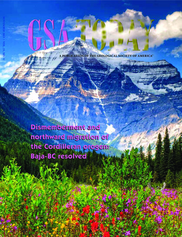
NOVEMBER 2015 VOLUME 25, NUMBER 11GSA TODAY (ISSN 1052-5173 USPS 0456-530) prints newsand information for more than 26,000 GSA member readersand subscribing libraries, with 11 monthly issues (March/April is a combined issue). GSA TODAY is published by TheGeological Society of America Inc. (GSA) with offices at3300 Penrose Place, Boulder, Colorado, USA, and a mailing address of P.O. Box 9140, Boulder, CO 80301-9140, USA.GSA provides this and other forums for the presentationof diverse opinions and positions by scientists worldwide,regardless of race, citizenship, gender, sexual orientation,religion, or political viewpoint. Opinions presented in thispublication do not reflect official positions of the Society. 2015 The Geological Society of America Inc. All rightsreserved. Copyright not claimed on content preparedwholly by U.S. government employees within the scope oftheir employment. Individual scientists are hereby grantedpermission, without fees or request to GSA, to use a singlefigure, table, and/or brief paragraph of text in subsequentwork and to make/print unlimited copies of items in GSATODAY for noncommercial use in classrooms to furthereducation and science. In addition, an author has the rightto use his or her article or a portion of the article in a thesisor dissertation without requesting permission from GSA,provided the bibliographic citation and the GSA copyrightcredit line are given on the appropriate pages. For anyother use, contact editing@geosociety.org.Subscriptions: GSA members: Contact GSA Sales & Service, 1-888-443-4472; 1-303-357-1000 option 3; gsaservice@geosociety.org for information and/or to place a claim fornon-receipt or damaged copies. Nonmembers and institutions:GSA TODAY is US 88/yr; to subscribe, or for claims fornon-receipt and damaged copies, contact gsaservice@geosociety.org. Claims are honored for one year; pleaseallow sufficient delivery time for overseas copies. Periodicals postage paid at Boulder, Colorado, USA, and atadditional mailing offices. Postmaster: Send addresschanges to GSA Sales & Service, P.O. Box 9140, Boulder,CO 80301-9140.GSA TODAY STAFFExecutive Director and Publisher: Vicki S. McConnellScience Editors: Steven Whitmeyer, James MadisonUniversity Dept. of Geology & Environmental Science,800 S. Main Street, MSC 6903, Harrisonburg, VA 22807,USA, whitmesj@jmu.edu; Gerald Dickens, Rice UniversitySchool of Earth Science, MS-126, 6100 Main Street,Houston, Texas 77005, USA, jerry@rice.edu.Featured ArticlesSCIENCE4Dismemberment and northwardmigration of the Cordilleran orogen:Baja-BC resolvedRobert S. HildebrandCover: The 3-km southwest face of Mount Robson (3,954 m)rises above summer wildflowers along Robson Creek inBritish Columbia, Canada. Composed of Cambrian sedimentary rocks, the peak is the most prominent in theCanadian sector of the Cordilleran fold-thrust belt. Photo byRobert S. Hildebrand. See related article, p. 4–11.GROUNDWORK34 We need to talk: Facilitating communicationbetween field-based geoscience and cyberinfrastructure communitiesMatty Mookerjee, Daniel Vieira, Marjorie A. Chan, Yolanda Gil, CharlesGoodwin, Thomas F. Shipley, and Basil TikoffGSA News11 35th International Geological Congress (IGC): Cape Town, South Africa12 2015–2016 Richard H. Jahns Distinguished Lecturer13 2016 Birdsall-Dreiss Distinguished Lecturer14 Upcoming Award, Recognition & Grant Deadlines14 2016 Student Research Grants16 Congratulations to All the 2015 GSA Division Award RecipientsManaging Editor: K.E.A. “Kea” Giles, kgiles@geosociety.org,gsatoday@geosociety.org20 Thank You 2015 GeoCorpsTM America Participants, Partners, and DonorsGraphics Production: Margo McGrew23 Thank You 2015 Mosaics in Science Participants and PartnersAdvertising (classifieds & display): Ann Crawford, 1-800-472-1988 ext. 1053; 1-303-357-1053; Fax: 1-303357-1070; advertising@geosociety.org; acrawford@geosociety.orgGSA Online: www.geosociety.orgGSA TODAY: www.geosociety.org/gsatoday/Printed in the USA using pure soy inks.24 GSA Education & Outreach Programs: 2016 Section Meetings25 Geoscience Jobs & Opportunities36 Travel Awards to NEGSA201636 2016 GSA Section Meetings37 GSA Foundation Update39 Call for Proposals: GSA 2016 Annual Meeting & ExpositionErratum: On page 22 of the October 2015 issue of GSA Today, David M. Raup waslisted as the first president of the Paleontological Society. He in fact was president in1977 (the first president was J.M. Clarke in 1909). GSA Today regrets this error.
Dismemberment and northward migration of the Cordilleranorogen: Baja-BC resolvedRobert S. Hildebrand, Dept. of Earth & Planetary Sciences,University of California, Davis, California 95616-8605, USA;rshildebrand@ucdavis.eduABSTRACTPaleomagnetic results indicate that much of the NorthAmerican Cordillera migrated more than 1000 km northwardduring the 80–58 Ma Laramide event, yet geologists cannot findeither the faults along which such movement might have takenplace or readily identifiable piercing points to document offset.Here, I suggest that the sinistral Texas Lineament, which extendswest-northwest from the Gulf of Mexico to the Cordilleran foldthrust belt southwest of Las Vegas, and the sinistral Lewis & Clarktransverse zone, located about 1300 kilometers to the north, andextending from southern Vancouver Island east-southeast to thethrust belt in the Helena salient, can be restored to one throughgoing zone to provide a piercing point that constrains meridionalmigration. I interpret the zone as the result of plate interactions ona left-stepping transform margin formed along the southernmargin of North America during Jurassic opening of the AtlanticOcean. The structure was dismembered and partly transportednorthward along faults in and/or adjacent to the Cordilleran foldthrust belt. The proposed restoration also reunites two conspicuous bands of Late Cretaceous–Paleocene slab-failure plutons andporphyry copper deposits into a single zone extending continuously along western North America. This reconstruction obviatesthe need for Laramide flat slab subduction.GSA TODAY NOVEMBER 2015INTRODUCTIONOne of the more contentious aspects of North AmericanCordilleran tectonics is the possible meridional migration, basedmostly on paleomagnetic evidence, of large sections of crust (Kerr,1995). This is the so-called Baja-BC controversy, which was bornwhen paleomagnetists discovered anomalously shallow paleomagnetic inclinations in Cretaceous rocks of the Canadian Cordillerarelative to those obtained from rocks of cratonic North America(Beck and Noson, 1972; Irving, 1979, 1985). The data imply that amajor portion of the coastal Cordillera of British Columbiamigrated northward 1000 km between about 90 and 60 Ma(Irving, 1985; Irving et al., 1996; Enkin, 2006).Geologists soon developed models that incorporated thepaleomagnetic data (Umhoefer, 1987; Johnston, 2001, 2008;Butler et al., 2001; Umhoefer and Blakey, 2006; Hildebrand,2013) but failed to present obvious matches between rocks ofBritish Columbia and those much farther south. So, evenGSA Today, v. 25, no. 11, doi: 10.1130/GSATG255A.1.4though (1) paleomagnetic data were compelling (Beck 1991);(2) the method worked well elsewhere in the world (Mac Niocaillet al., 2003); and (3) the long-standing northerly orientation of theCordilleran margin would seem to be ideal for paleomagneticstudies, the geological community hasn’t accepted that thousandsof kilometers of translation had occurred because piercing pointsweren’t readily located and because geologists couldn’t identifythe faults along which such large displacements took place (Kerr,1995; Mahoney et al., 1999; Nelson et al., 2013).In this contribution, I show that meridional migration withinthe Cordillera was not confined to narrow slivers along the coast,but instead involved the entire width of the Cordillera, from theLaramide fold-thrust belt westward, as hypothesized by Enkin etal. (2006a), Johnston (2008), and Hildebrand (2009, 2013). Byutilizing simple cross-cutting relationships and two piercingpoints to constrain and support large-scale meridional migration,I bring the paleomagnetic data into consilience with the geologicaldata to resolve the longstanding Baja-BC controversy.GEOLOGYDecades ago Phil King (King, 1969) divided the Cordillera intothree along-strike sectors—northern, central, and southern—based on geological differences across two transverse boundaries: the Lewis & Clark transverse zone of Montana and Idahoand the Texas Lineament, which was considered to extend fromthe Transverse Ranges of California to the Gulf of Mexico.Regarding the southern boundary, he wrote (p. 72):The zone is a strip of country as much as 160 km (100miles) wide that separates two parts of the Cordillerawith different topographies, geologic histories, and stylesof deformation. South of the zone the Cordilleran foldbelt extends 800 km (500 miles) farther east than on thenorth side, and for long distances its deformed rocksclosely adjoin little deformed rocks in the ColoradoPlateau and the block mountains of New Mexico, whichare reactivated or disrupted parts of the former craton.These contrasts have not been produced by transversefaulting, and the Texas Lineament is not a throughgoing fault zone, as has sometimes been assumed.In my earliest paper on the Cordillera (Hildebrand, 2009), Inoted the many changes along the southern margin of theColorado Plateau and hypothesized that there must be a fault,which I called the Phoenix fault, separating the non-extendedColorado Plateau from the extended zone to the south. At thetime, I was unaware of King’s boundaries and was flummoxedbecause I could not decide whether the fault was transform or
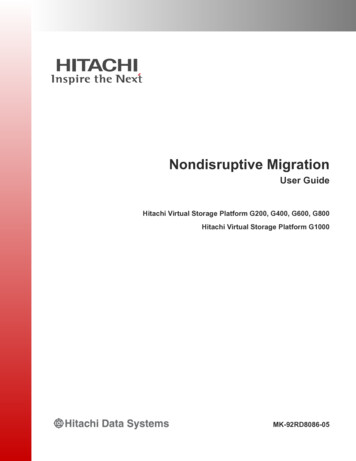
Figure 1. Geological sketch map of west-central North America showing the two transverse structural zones and geologically relevant units. Geology from Reedet al. (2004) with local detail from sources cited in the text; 80 Ma contours of Cretaceous rocks from Roberts and Kirschbaum (1995); Great Basin calderas fromHenry and John (2013); Late Cretaceous-Paleocene Sri isopleths from Armstrong et al. (1977). Inset: The Gulf of Mexico region simplified from Reed et al. (2004)showing the sinistral separation of Gulf salt (reflected in salt domes) and the southward truncation of the high-amplitude magnetic high that is interpreted torepresent basalts of a volcanic rifted margin (Mickus et al., 2009). The Mexican ridges province is characterized by detachments in shale, whereas elsewhere inthe Gulf, detachments are in salt (Rowan et al., 2004).5
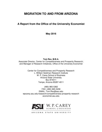
GSA TODAY NOVEMBER 2015Figure 2. Simplified map showing many of the main Cordilleran elementsdiscussed in the text. Rotation of Colorado Plateau from Kent and Witte(1993).6transcurrent. For example, it was obvious that, in addition to thethrust belt, the Neogene Basin and Range structural provinceoccurs much farther west, north of the lineament, than its equivalent in Mexico (Fig. 1), yet I knew that it couldn’t be a youngertranscurrent fault because 18.8 Ma Peach Spring Tuff (Fig. 1)crops out in a narrow band from Arizona to near Barstow,California (Glazner et al., 1986) and extends unbroken over thetrace of the zone.Besides the separation of the Basin and Range and the thrustbelt, many other features display sinistral separation across thelineament (Fig. 1): The post-Sevier dynamic basin (as illustratedby the 80 Ma isopachs), the Laramide belt of porphyry copperdeposits (Gilmer et al., 2003), and possibly the Oligocene ignimbrite flare-up (Henry and John, 2013) all show sinistral separation. The oldest rocks that show obvious sinistral separationacross the zone are the Callovian salt deposits of the Gulf ofMexico (Fig. 1).Features restricted to the region north of the Texas Lineamentinclude the Colorado Plateau, the Rio Grande rift, the High Plainsprovince, and the Ouachita-Marathon orogen. Features largelylimited to the region south of the lineament include the Sonoranbatholith, related porphyry Cu deposits, and the Pinal schist(Fig. 1).The Rio Grande rift disappears southward into the MexicanBasin and Range, whereas the unbroken High Plains just west ofthe 100th meridian trend southerly into the Mexican Basin andRange (Figs. 1 and 2). Paleozoic features, such as the OuachitaMarathon fold-thrust belt and strata of the Permian Basin, aretruncated and do not appear south of the lineament, whereas themuch younger Late Cretaceous–Paleocene Sonoran batholithextends northward into Arizona but remains mostly south of thelineament and extends westward through the Transverse Ranges,where it ends (Fig. 1). The northwesterly tip of the TexasLineament zone is obscure and cannot be traced beyond the areajust southwest of Las Vegas, where the Cordilleran fold-thrust beltalso appears to terminate in the complexly faulted Mojave regionof eastern California (e.g., figure 14 in Burchfiel et al., 1992).The Lewis & Clark transverse zone (Fig. 1), which King (1969)used to separate the central from the northern Cordillera, issimilar to the Texas Lineament in that it ends at the Laramidethrust belt, and most units north and south display sinistral separation or are truncated against it (Figs. 1 and 2). Late Cretaceous–Paleocene magmatic rocks in Idaho and Montana, of which theIdaho and Boulder batholiths are examples, continue north of thezone but display a sinistral step before continuing farther northward through the High Cascades and the Coast plutonic complexof British Columbia (Fig. 1).Following the same trends as the plutonic rocks is the prominent left step in the initial Sr isopleths of Late Cretaceous–Paleocene rocks (Armstrong et al., 1977; Fleck and Criss, 1985).A few plutons of a 100–80 Ma plutonic belt—interpreted farthersouth as slab-failure plutons related to the 100 Ma Oregonianevent (Hildebrand and Whalen, 2014)—occur within the Idahobatholith and to the west in the Cascades and Coast plutoniccomplex north of the zone. Eocene magmatism and corecomplexes (Foster et al., 2007) also display a sinistral separationacross the zone (Fig. 1), whereas three other Cenozoic groups ofrocks—dikes and lavas of the Columbia River Basalt Group(Reidel et al., 2013), volcanic and sedimentary rocks of theAncestral Cascades (du Bray and John, 2011), and dominantlybasaltic rocks of Siletzia (Wells et al., 2014)—all abut northwardagainst the zone (Figs. 1 and 2). The classic Laramide basementuplifts and basins (Fig. 1), characteristic of the central Cordillera,are largely confined to the area south of the Lewis & Clark zoneand north of the Texas Lineament (Fig. 1).Based on the absence of sinistral separation across them, rocksof the Belt Supergroup appear to sit atop the Lewis & Clark transverse zone, but the zone expresses itself in the overlying Belt rockswith a linear band of abundant faults, folds, and intense cleavage(Wallace et al., 1990; Sears, 1988). A conspicuous band of LateCretaceous sedimentary rocks located west and south of theBoulder batholith (Fig. 1) is an order of magnitude thicker, and isstratigraphically quite different, south of the zone than correlativerocks to the north in the Montana disturbed belt (Wallace et al.,1990). Jurassic-Cretaceous rocks of the Tyaughton-Methow basin(Umhoefer et al., 2002), and those of the Upper CretaceousNanaimo basin on Vancouver Island (Mustard, 1994) do notcontinue south of the transverse zone (Fig. 1).BAJA-BC RESOLVEDSeveral robust and repeatable paleomagnetic studies exist forthe region north of the Lewis & Clark zone. I summarize theresults of several, plus an interesting study of leaf fossils thatyielded congruent results, in Figure 3. The results are similar, butthose from older Cretaceous rocks have slightly larger amounts ofdisplacement relative to the craton, largely because North Americastarted to move southward at 90 Ma (Kent and Irving, 2010).A breakthrough in our understanding occurred through paleomagnetic study of the Carmacks Group (Fig. 3), which yielded ca.70 Ma paleopoles indicating 1950 600 km northward translationrelative to cratonic North America (Enkin et al., 2006a). Thegroup is an amalgamation of 72–69 Ma volcanic and sedimentary
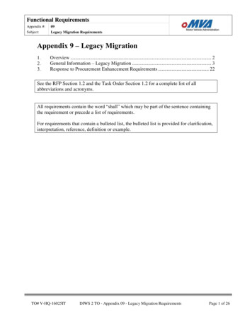
Figure 3. Google Earth map showing key paleomagnetic results for mid- toUpper Cretaceous rocks and separation of Late Cretaceous–Early CenozoicLaramide slab failure rocks. Symbols without inner black dots are currentlocations, whereas those with dots are their paleomagnetically restoredlatitudes. Note that restoring the Lewis & Clark zone with the Texas Lineamentis consistent with the paleomagnetic data and also reunites the Laramidemagmatic belt. Leaf margin data from Miller et al. (2006); Nanaimo pointsfrom Kent and Irving (2010) and Kim and Kodama (2004); Carmacks fromEnkin et al. (2006a); Silverquick–Powell Creek from Enkin et al. (2006b);Fernie, British Columbia (BC), from Enkin et al. (2000); Blue Mountains fromHousen and Dorsey (2005).America, respectively (Housen and Dorsey, 2005; Enkin et al.,2006a) so they support the geological restoration. Thus, the transverse zones provide a piercing point consistent with the paleo magnetic data (Fig. 3).I propose that the restored transverse zone represents a step inthe southern margin of North America, and—because the oldestknown rocks to exhibit sinistral separation across the zone areCallovian salt deposits beneath the Gulf of Mexico—that itformed as a sinistral transform fault during Jurassic opening ofthe central Atlantic Ocean. The northwest extent of the zone islocated today around southern Vancouver Island, but theGSA TODAY www.geosociety.org/gsatodayrocks located in the Canadian Cordillera north of Whitehorse(Fig. 3). Rocks of the group sit unconformably on rocks of theYukon-Tanana terrane, which collided and joined with Cassiarplatform and Selwyn basin during the Late Permian (Berenek andMortensen, 2011); were all overlapped by Triassic conglomerate(Berenek and Mortensen, 2007); and cut by abundant mid-Cretaceous plutons (Rasmussen, 2013). Thus, the paleomagnetic resultsfrom much younger rocks of the Carmacks Group apply to thoseterranes as well (Gladwin and Johnston, 2006). The results,supported by data from earlier, but less conclusive, studies farthersouth in the Canadian Front Ranges (Enkin et al., 2000) ledRandy Enkin to conclude that the majority of northward translation took place on “unidentified structures located east of theSelwyn basin” (Enkin et al., 2006a).Paleomagnetic studies farther south in Albian-Cenomanianturbiditic rocks of the Blue Mountain terranes, Oregon, yieldedpaleopoles 1760 460 km discordant to North American polesat about 93 Ma (Housen and Dorsey, 2005). Rocks of the BlueMountains–Riggins terranes were joined to rocks of the BeltSupergroup along the Salmon River suture between 111 and90 Ma (Manduca et al., 1993; Unruh et al., 2008), and, becauserocks of the Belt Supergroup form one giant allochthon (Sears,2007; Fuentes et al., 2012) that was thrust over Upper Cretaceoussedimentary rocks in the Cordilleran fold-thrust belt, thepaleomagnetic results from the Ochoco Basin should apply torocks of the Belt Supergroup as well. These results are consistentwith the Carmacks results and together indicate that northwardmigration of the entire Cordilleran tectonic collage took placealong faults within or east of the Cordilleran fold-thrust belt afterabout 70 Ma.I recognized (Hildebrand, 2013, 2014) that the 125–105 MaSevier event was separate and distinct from the 80–58 MaLaramide event and confined to the Great Basin sector of theorogen. And, based on geological and geophysical features, suchas the distribution of eastwardly vergent thrusts, the lack ofan arc on North American crust, and compelling new mantletomography (Sigloch and Mihalynuk, 2013), I argued thatsubduction was westerly dipping. I also noted that slab-failuremagmatism and thrust faults related to the Sevier event are notfound in the Great Basin west of the fold-thrust belt whereexpected, but instead are located in the Canadian Cordillera.This, along with the Carmacks paleomagnetic data, and evidencethat the Laramide foredeep migrated northward during thelatest Cretaceous–Paleocene (Cataneanu et al., 2000; Roberts andKirschbaum, 1995), led me to argue that the entire Cordilleramigrated northward during the Laramide event (Hildebrand,2014). However, other than the band of likely slab-failure plutonsand the mismatched thrust belts, I presented no real piercingpoints, so the arguments, although cogent to some, were notcompelling to all.The left-stepping nature of the geology along both the Lewis& Clark transverse zone and the Texas Lineament, their similarorientations, and the observation that both appear to be truncatedat the Laramide fold-thrust belt, suggest that the two zones wereonce continuous and separated during the Laramide event on oneor more faults in, or adjacent to, the thrust belt. Currently, the twozones are 1300 km apart. Paleomagnetic studies from theCarmacks volcanics and the Blue Mountains terranes have paleopoles 1760 460 and 1950 600 km discordant to cratonic North7
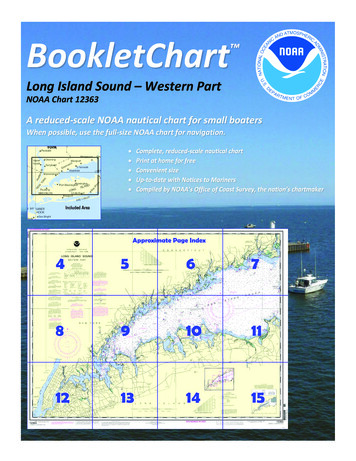
GSA TODAY NOVEMBER 2015Figure 4. Much simplified reconstruction ofmargin just prior to northward migrationillustrating continuity of Late Cretaceous–EarlyTertiary magmatic belt. The sinuous shape ofthe magmatic belt reflects the shape of thesouthwestern margin of North Americaimmediately after terminal collision of theCordilleran Ribbon Continent.8Cordilleran fold-thrust belt terminates just southwest of Las Vegasand to the south resumes 800 km farther east, as noted by King(1969). South of the zone, terranes collided with North Americamuch farther east than to the north, but the overall geology issimilar in many respects simply because some of the same eventstook place on both sectors of the continental margin. Others, such asdeformational features related to the 125–110 Ma Sevier event, haveno recognized counterpart to the south because the impingingblock, which Stephen Johnston and I (Johnston, 2008; Hildebrand,2013) argued to have been a ribbon continent, did not arrive thereuntil much later, as suggested by the coincidence of the distinctiveeastward-extending prong of the mantle fast-zone (Sigloch andMihalynuk, 2013), and the meridionally restored location of theGreat Basin region, at about 125 Ma (Hildebrand, 2014).A major Late Cretaceous–Paleocene magmatic belt, interpretedby Hildebrand (2013) to represent Laramide slab failure magmatism and metallogenesis, extends from Alaska to just south of theLewis & Clark transverse zone and from southern Mexico to theTransverse Ranges (Figs. 1 and 2). It provides another robustpiercing point. The present-day magmatic gap in between thetwo was perhaps the most important reason to ascribe Laramidethick-skinned deformation to flat-slab subduction (Dickinson andSnyder, 1978; Humphreys, 2009), but by reuniting the transversezones, the two belts of Laramide magmatism and their relatedporphyry copper deposits are joined, obliterating the magmaticgap and validating the overall reconstruction (Fig. 4).It is worth noting that the Laramide magmatic belt has exhumation ages of 70–50 Ma over its entire length (Miller andMorton, 1980; Wells and Hoisch, 2008; Miller et al., 2009;Armstrong, 1988) and that there are two bands of Laramidedeformation: the better known band, mostly without proximalmagmatism, located in the eastern Cordillera, and another withassociated high-grade metamorphism and generally rapidexhumation located farther west in or adjacent to the magmaticbelt. The deformation, magmatism, and exhumation are wellknown throughout the Transverse Ranges and Mojave Desertregion of Southern California and Arizona (Haxel et al., 1984;May, 1989; Needy et al., 2009), as well as in the Cascades andCoast plutonic complex of British Columbia and the Yukon(Miller et al., 2009; Rusmore and Woodsworth, 1991; Parrish,1992; Evenchik et al., 2007; Johnston and Canil, 2007).Overall, the proposed reconstruction resolves many longstanding issues in Cordilleran geology and hints at solutions tomany more. Not only are the paleomagnetic data accounted for,and the Baja-BC controversy resolved, but the currently dismembered Laramide magmatic, deformational, and metamorphiccollisional belt is reunited and validates the reconstruction.Hopefully, this initial first-order model will lead others to workbackward through time to better understand the development ofthe Cordilleran orogen. Many more surprises are yet to come.CONCLUSIONS1. Similar relationships of well-dated and mapped units alongboth sides of the Lewis & Clark zone and the Texas Lineamentsuggest that the two features were formerly continuous.2. By restoring 1300 km of dextral slip along the Cordilleranfold-thrust belt—about the minimum indicated from paleomagnetic data—the Lewis & Clark transverse zone and theTexas Lineament are aligned into a continuous structure. Thereconstruction is simple and clarifies many relationships thatwere previously difficult to explain.3. In the reconstruction (Fig. 4), the Laramide collision zone andits exhumed upper-plate slab-failure rocks occur in a continuous band from southern Mexico through the TransverseRanges into the Cascades and Coast plutonic complex. Thus,there was no magmatic gap during the Laramide.
ACKNOWLEDGMENTSRandy Enkin, Charlie Kerans, Dennis Kent, Eldridge Moores, and CharlieRoots read the first draft and suggested improvements. Robert Hatcherand Stephen Johnston critically reviewed the manuscript and made helpfulcomments. I dedicate this paper to the memory of Ted Irving.REFERENCES CITEDArmstrong, R.L., 1988, Mesozoic and early Cenozoic magmatic evolution of theCanadian Cordillera, in Clark, S.P., Burchfiel, B.C., and Suppe, J., eds.,Processes in Continental Lithosphere Deformation: Geological Society ofAmerica Special Paper 218, p. 55–91.Armstrong, R.L., Taubeneck, W.H., and Hales, P.O., 1977, Rb-Sr and K-Argeochronometry of Mesozoic granitic rocks and their Sr isotopiccomposition, Oregon, Washington, and Idaho: GSA Bulletin, v. 88,p. 397–411, doi: 10.1130/0016-7606(1977)88 397:RAKGOM 2.0.CO;2.Beck, M.E., Jr., 1991, Case for northward transport of Baja and coastal southernCalifornia: Paleomagnetic data, analysis, and alternatives: Geology, v. 19,p. 506–509, doi: 10.1130/0091-7613(1991)019 0506:CFNTOB 2.3.CO;2.Beck, M.E., Jr., and Noson, L., 1972, Anomalous paleolatitudes in Cretaceousgranitic rocks: Nature. Physical Science, v. 235, p. 11–13, doi: 10.1038/physci235011a0.Beranek, L.P., and Mortensen, J.K., 2007, Investigating a Triassic overlapassemblage in Yukon: On-going field studies and preliminary detrital-zirconage data, in Emond, D.S., Lewis, L.L., and Weston, L.H., eds., YukonExploration and Geology 2006: Yukon Geological Survey, p. 83–92.Beranek, L.P., and Mortensen, J.K., 2011, The timing and provenance record ofthe Late Permian Klondike orogeny in northwestern Canada and arccontinent collision along western North America: Tectonics, v. 30,TC5017, doi: 10.1029/2010TC002849.Burchfiel, B.C., Cowan, D.S., and Davis, G.A., 1992, Tectonic overview of theCordilleran orogen in the western U.S., in Burchfiel, B.C., Lipman, P.W.,and Zoback, M.L., eds., The Cordilleran Orogen: Conterminous U.S.:Boulder, Colorado, Geological Society of America, Geology of NorthAmerica, v. G-3, p. 407–480.Butler, R.F., Gehrels, G.E., and Kodama, K.P., 2001, A moderate translationalternative to the Baja British Columbia hypothesis: GSA Today, v. 11,p. 4–10, doi: 10.1130/1052-5173(2001)011 0004:AMTATT 2.0.CO;2.Catuneanu, O., Sweet, A.R., and Miall, A.D., 2000, Reciprocal stratigraphyof the Campanian–Paleocene Western Interior of North America:Sedimentary Geology, v. 134, p. 235–255, doi: 10.1016/S0037-0738(00)00045-2.Dickinson, W., and Snyder, W.S., 1978, Plate tectonics of the Laramide orogeny,in Matthews, V., III, ed., Laramide Folding Associated with BasementBlock Faulting in the Western United States: Geological Society ofAmerica Memoir 151, p. 335–366.du Bray, E.A., and John, D.A., 2011, Petrologic, tectonic, and metallogenicevolution of the ancestral Cascades magmatic arc, Washington, Oregon,and northern California: Geosphere, v. 7, p. 1102–1133, doi: 10.1130/GES00669.1.Engebretson, D.C., Cox, A., and Gordon, R.G., 1985, Relative Motions betweenOceanic and Continental Plates in the Pacific Basin: Geological Society ofAmerica Special Paper 206, 59 p.Enkin, R.J., 2006, Paleomagnetism and the case for Baja British Columbia, inHaggart, J.W., Enkin, R.J., and Monger, J.W.H., eds., Paleogeography ofthe North American Cordillera: Evidence for and against Large-ScaleDisplacements: St. John’s, Newfoundland, Geological Association ofCanada Special Paper 46, p. 233–254.Enkin, R.J., Osadetz, K.G., Baker, J., and Kisilevsky, D., 2000, Orogenicremagnetizations in the Front Ranges and inner foothills of the southernCanadian Cordillera: Chemical harbinger and thermal handmaiden ofCordilleran deformation: GSA Bulletin, v. 112, p. 929–942, doi: 10.1130/0016-7606(2000)112 929:ORITFR 2.0.CO;2.Enkin, R.J., Johnston, S.T., Larson, K.P., and Baker, J., 2006a, Paleomagnetismof the 70 Ma Carmacks Group at Solitary Mountain, Yukon, confirmsand extends controversial results: Further evidence for the Baja BritishColumbia model, in Haggart, J.W., Enkin, R.J., and Monger, J.W.H., eds.,Paleogeography of the North American Cordillera: Evidence for andagainst Large-Scale Displacements: St. John’s, Newfoundland, GeologicalAssociation of Canada Special Paper 46, p. 221–232.Enkin, R.J., Mahoney, J.B., and Baker, J., 2006b, Paleomagnetic signature of theSilverquick/Powell Creek succession, south-central British Columbia:Reaffirmation of Late Cretaceous large-scale terrane translation, inHaggart, J.W., Enkin, R.J., and Monger, J.W.H., eds., Paleogeography ofthe North American Cordillera
Robert S. Hildebrand Cover: The 3-km southwest face of Mount Robson (3,954 m) rises above summer wildflowers along Robson Creek in British Columbia, Canada. Composed of Cambrian sedi-mentary rocks, the peak is the most prominent in the Canadian sector of the Cordilleran fold-thrust belt. Photo by Robert S. Hildebrand. See related article, p. 4 .