Transcription
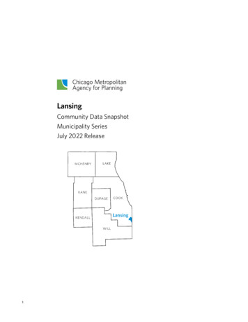
EnglewoodCommunity Data SnapshotChicago Community Area SeriesJuly 2022 Release1
Community Data Snapshot EnglewoodAbout the Community Data SnapshotsThe Community Data Snapshots is a series of data profiles for every county, municipality, and Chicago Community Area (CCA)within the Chicago Metropolitan Agency for Planning (CMAP) seven-county northeastern Illinois region. The snapshots primarilyfeature data from the American Community Survey (ACS) five-year estimates, although other data sources include the U.S.Census Bureau, Illinois Environmental Protection Agency (IEPA), Illinois Department of Employment Security (IDES), IllinoisDepartment of Revenue (IDR), HERE Technologies, and CMAP itself.CMAP publishes updated Community Data Snapshots annually to reflect the most recent data available. The latest version canalways be found at cmap.illinois.gov/data/community-snapshots. The underlying data can be downloaded from the CMAP DataHub. Please direct any inquiries to info@cmap.illinois.gov.To improve the Community Data Snapshots in the future, CMAP wants to hear from you! Please take a quick survey to describehow you use this data and what you would like to see in next year’s snapshots.User NotesDefinitionsFor data derived from the ACS, the Community Data Snapshots uses terminology based on the ACS subject definitions.Margins of ErrorThe ACS is a sample-based data product. Exercise caution when using data from low-population communities, as the margins oferror are often large compared to the estimates. For more details, please refer to the ACS sample size and data qualitymethodology.Regional ValuesRegional values are estimated by aggregating ACS data for the seven counties that compose the CMAP region. These countiesare Cook, DuPage, Kane, Kendall, Lake, McHenry, and Will.Chicago Community Area (CCA) ValuesCCA values are estimated by aggregating ACS data for census tracts and block groups. Data from tracts and block groupslocated in multiple CCAs is allocated proportionally based on the block-level distribution of population, households or housingunits (as appropriate) from the most recent Decennial Census.Median ValuesThe Census Bureau encourages users to aggregate small levels of geographies into larger areas to estimate median values forthose areas. Median values for the aggregated geographies (CCAs and the CMAP region) are estimated from the groupedfrequency distributions reported in the ACS.2
Community Data Snapshot EnglewoodPopulation and HouseholdsThe population and household tables include general demographic, social, and economic characteristics summarized forEnglewood.General Population Characteristics, 2020EnglewoodCity of ChicagoCMAP ercentCity of ChicagoCountPercentCMAP RegionCountPercentTotal PopulationTotal HouseholdsAverage Household SizePercent Population Change, 2010-20Percent Population Change, 2000-20Source: 2000, 2010 and 2020 Census.Race and Ethnicity, 2016-2020White (Non-Hispanic)Hispanic or Latino (of Any Race)Black (Non-Hispanic)Asian (Non-Hispanic)Other/Multiple Races Source: 2016-2020 American Community Survey five-year 350.623.116.57.32.5Universe: Total populationAge Cohorts, 2016-2020CountUnder 55 to 1920 to 3435 to 4950 to 6465 to 7475 to 8485 and OverMedian ,00057635.8Source: 2016-2020 American Community Survey five-year estimates.310.220.019.214.320.98.34.52.6City of .71.6CMAP 019.28.44.11.9Universe: Total population
Community Data Snapshot EnglewoodEducational Attainment*, 2016-2020EnglewoodCountPercentLess than High School DiplomaHigh School Diploma or EquivalentSome College, No DegreeAssociate’s DegreeBachelor’s DegreeGraduate or Professional 1City of ,360321,195Source: 2016-2020 American Community Survey five-year estimates.*Highest degree or level of school completed by an individual.14.122.017.25.724.017.1CMAP 1,412,295934,42311.022.418.97.124.516.2Universe: Population 25 years and olderNativity, 2016-2020EnglewoodCountPercentNativeForeign Born21,30471596.83.2City of ChicagoCountPercent2,152,712546,63579.720.3Source: 2016-2020 American Community Survey five-year estimates.CMAP se: Total populationLanguage Spoken at Home and Ability to Speak English, 2016-2020EnglewoodCountPercentEnglish OnlySpanishSlavic LanguagesChineseTagalogArabicKoreanOther Asian LanguagesOther Indo-European LanguagesOther/Unspecified LanguagesTOTAL NON-ENGLISHSpeak English Less than “Very 00.30.00.00.10.41.25.92.9City of ce: 2016-2020 American Community Survey five-year estimates.*For people who speak a language other than English at home, the ACS asks whether they speak English“very well,” “well,” “not well,” or “not at AP e: Population 5 years and older
Community Data Snapshot EnglewoodHousehold Size, 2016-2020EnglewoodCountPercent1-Person Household2-Person Household3-Person Household4-or-More-Person Household4,2242,2281,1341,58046.124.312.417.2City of 529.813.619.0Source: 2016-2020 American Community Survey five-year estimates.CMAP 30.915.624.3Universe: Occupied housing unitsHousehold Type, 2016-2020EnglewoodCountPercentFamilySingle Parent with ChildNon-Family4,6011,7884,56550.219.549.8City of Source: 2016-2020 American Community Survey five-year estimates.CMAP 35.7Universe: Occupied housing unitsHousehold Income, 2016-2020EnglewoodCountPercentLess than 25,000 25,000 to 49,999 50,000 to 74,999 75,000 to 99,999 100,000 to 149,999 150,000 and OverMedian IncomePer Capita Income*5,0422,2671,016374352115 22,228 15,03455.024.711.14.13.81.3City of ,086182,998 62,097 39,06822.919.115.311.514.316.9Source: 2016-2020 American Community Survey five-year estimates.CMAP 161644,573 76,606 40,60116.117.415.712.717.620.4Universe: Occupied housing units*Universe: Total populationHousehold Computer and Internet Access, 2016-2020EnglewoodCountPercentOne or More Computing DevicesSmartphone(s) OnlyNo Computing DevicesInternet AccessBroadband SubscriptionNo Internet Access7,1832,2021,9836,3605,8762,806Source: 2016-2020 American Community Survey five-year estimates.578.424.021.669.464.130.6City of ,381146,98290.49.79.686.482.613.6CMAP RegionCount 0,53892.77.27.389.887.210.2Universe: Occupied housing units
Community Data Snapshot EnglewoodHousing Occupancy and Tenure, 2016-2020EnglewoodCountPercentOccupied Housing UnitsOwner-Occupied*Renter-Occupied*Vacant Housing Units9,1662,1956,9714,47467.223.976.132.8City of 8.845.354.711.2Source: 2016-2020 American Community Survey five-year estimates.CMAP RegionCount 5.87.8Universe: Housing units*Universe: Occupied housing unitsHousing Costs as a Percentage of Household Income*, 2016-2020EnglewoodCountPercentLess than 20,000Less than 20 Percent20 to 29 Percent30 Percent or More 20,000 to 49,999Less than 20 Percent20 to 29 Percent30 Percent or More 50,000 to 74,999Less than 20 Percent20 to 29 Percent30 Percent or More 75,000 or MoreLess than 20 Percent20 to 29 Percent30 Percent or 09.98.01.50.4Source: 2016-2020 American Community Survey five-year estimates.*Excludes households with zero/negative income, and renting households paying no cash rent.6City of 15.64.75.75.344.029.511.13.5CMAP RegionCount 4.95.75.451.935.012.84.2Universe: Occupied housing units
Community Data Snapshot EnglewoodHousing CharacteristicsThe housing characteristics tables include housing unit estimates by housing type, size, and age summarized for Englewood.Housing Type, 2016-2020Single Family, DetachedSingle Family, Attached2 Units3 or 4 Units5 to 9 Units10 to 19 Units20 or More UnitsMobile 9433252,3186924.82.330.515.66.92.417.00.5City of Source: 2016-2020 American Community Survey five-year estimates.*“Other” includes boats, recreational vehicles (RVs), vans, etc.CMAP 8Universe: Housing unitsHousing Size, 2016-2020Count0 or 1 Bedroom2 Bedrooms3 Bedrooms4 Bedrooms5 or More BedroomsMedian Number of .933.532.810.44.4City of 9604.826.434.326.98.73.8Source: 2016-2020 American Community Survey five-year estimates.*Includes living rooms, dining rooms, kitchens, bedrooms, etc., that are separated by built-in, floor-to-ceiling walls.Excludes bathrooms, porches, balconies, foyers, halls, and unfinished basements.CMAP 2,1576.016.128.033.317.65.0Universe: Housing unitsHousing Age, 2016-2020CountBuilt 2000 or LaterBuilt 1970 to 1999Built 1940 to 1969Built Before 1940Median Year e: 2016-2020 American Community Survey five-year estimates.79.618.930.041.6City of 111.117.630.940.3CMAP 196914.034.430.521.1Universe: Housing units
Community Data Snapshot EnglewoodTransportationThe transportation tables include vehicle availability by household, mode of travel to work, annual vehicle miles traveled, andtransit availability for Englewood.Vehicles Available per Household, 2016-2020EnglewoodCountPercentNo Vehicle Available1 Vehicle Available2 Vehicles Available3 or More Vehicles Available4,4543,2881,06535948.635.911.63.9City of 43.922.07.4Source: 2016-2020 American Community Survey five-year estimates.CMAP 12.735.435.016.9Universe: Occupied housing unitsMode of Travel to Work, 2016-2020CountWork at Home*Drive AloneCarpoolTransitWalk or BikeOtherTOTAL COMMUTERSMean Commute Time 5537.86.347.76.334.82.72.293.7Source: 2016-2020 American Community Survey five-year estimates.*Not included in total commuters or mean commute time.City of P iverse: Workers 16 years and olderAnnual Vehicle Miles Traveled per Household*, 2017EnglewoodCity of ChicagoCMAP Region7,28710,90817,165Average Vehicle Miles Traveled per YearSource: Chicago Metropolitan Agency for Planning analysis of 2017 Illinois Environmental Protection Agency, HERE Technologies, and U.S. Census Bureaudata.*Data not available for all communities in the CMAP region.Transit Availability of Resident and Job Locations*, 2017High Transit AvailabilityModerate Transit AvailabilityLow Transit AvailabilityEnglewoodCity of ChicagoCMAP urce: Chicago Metropolitan Agency for Planning analysis of the 2017 Transit Availability Index.*The CMAP Transit Availability Index is based on four factors: frequency of transit service, proximity to transit stops, activities reachable without a transfer, andpedestrian friendliness. This table reports the share of residents plus jobs whose home and workplace locations, respectively, are within each Transit AvailabilityIndex category.8
Community Data Snapshot EnglewoodEmploymentThe employment tables include general workforce characteristics for Englewood.Employment Status, In Labor ForceEmployed†*Unemployed*Not in Labor Force50.875.124.949.2City of ChicagoCount 32.8Source: 2016-2020 American Community Survey five-year estimates.†Does not include employed population in the Armed Forces.67.393.66.232.7Employment in Englewood*, .23,0451,1835523619740.915.97.44.81.3TOP INDUSTRY SECTORS1. Health Care2. Retail Trade3. Other Service4. Education5. Accommodation and FoodServiceTOP RESIDENCE LOCATIONS1. Outside of Chicago2. Englewood3. Auburn Gresham4. Greater Grand Crossing5. South ShoreSource: U.S. Census Bureau, Longitudinal Employer-Household Dynamics program (2019).*Excludes residents working outside of, and workers living outside of, the seven-county CMAP : Population 16 years and older*Universe: In labor forceEmployment of Englewood Residents*, 2019TOP INDUSTRY SECTORS1. Health Care2. Administration3. Retail Trade4. Accommodation and FoodService5. TransportationTOP EMPLOYMENT LOCATIONS1. Outside of Chicago2. The Loop3. Near North Side4. Near West Side5. Near South SideCMAP RegionCount 5538357534936.45.53.83.53.2
Community Data Snapshot EnglewoodLand UseThe land use tables include general land use composition, park access, and walkability for Englewood.General Land Use, 2015Single-Family ResidentialMulti-Family ResidentialCommercialIndustrialInstitutionalMixed UseTransportation and OtherAgriculturalOpen 6.20.02.222.5100.0Source: Chicago Metropolitan Agency for Planning analysis of the 2015 Land Use Inventory.Park Access, 2015Accessible Park Acreage per 1,000Residents*EnglewoodCity of ChicagoCMAP Region2.352.425.78Source: Chicago Metropolitan Agency for Planning analysis of the 2015 Park Access Layer.*Neighborhood parks (smaller than 35 acres) are considered accessible for residents living within 0.5 miles; community parks (35 acres or larger) areconsidered accessible for residents living within 1 mile.Walkability of Resident and Job Locations*, 2018High WalkabilityModerate WalkabilityLow WalkabilityEnglewoodCity of ChicagoCMAP urce: Chicago Metropolitan Agency for Planning analysis of the 2018 Walkability Layer.*The CMAP Walkability Layer is based on several factors: the presence/absence of sidewalks; the number of amenities within walking distance;population/employment density; bicycle/pedestrian crashes and fatalities; and physical characteristics (e.g., tree cover, block length). This table reports theshare of residents plus jobs whose home and workplace locations, respectively, are within each Walkability Layer category.10
Community Data Snapshot Englewood Time SeriesChange Over TimeThe time series tables include comparisons of current 2016-2020 ACS estimates to historic year estimates from the 2000Census and 2006-2010 ACS.Race and Ethnicity, Over TimeWhite (Non-Hispanic)Hispanic or Latino (of Any Race)Black (Non-Hispanic)Asian (Non-Hispanic)Other/Multiple Races .62.2Source: 2000 Census; 2006-2010 and 2016-2020 American Community Survey five-year estimates.Universe: Total populationAge Cohorts, Over Time19 and Under20 to 3435 to 4950 to 6465 and OverMedian 212.230.730.219.214.320.915.535.8Source: 2006-2010 and 2016-2020 American Community Survey five-year estimates.Universe: Total populationEducational Attainment*, Over TimeLess than High School DiplomaHigh School Diploma or EquivalentSome College, No DegreeAssociate’s DegreeBachelor’s DegreeGraduate or Professional DegreeSource: 2006-2010 and 2016-2020 American Community Survey five-year estimates.*Highest degree or level of school completed by an 3.024.86.04.72.123.735.425.56.56.82.1Universe: Population 25 years and older
Community Data Snapshot Englewood Time SeriesNativity, Over TimeNativeForeign 2Source: 2006-2010 and 2016-2020 American Community Survey five-year estimates.Universe: Total population*Universe: Population 5 years and olderLanguage Spoken at Home and Ability to Speak English, Over TimeEnglish OnlySpanishSlavic LanguagesChineseTagalogArabicKoreanOther Asian LanguagesOther Indo-European LanguagesOther/Unspecified LanguagesTOTAL NON-ENGLISHSpeak English Less than “Very .10.41.25.92.9Source: 2006-2010 and 2016-2020 American Community Survey five-year estimates.*For people who speak a language other than English at home, the ACS asks whether they speak English“very well,” “well,” “not well,” or “not at all.”12Universe: Population 5 years and older
Community Data Snapshot Englewood Time SeriesHousehold Size, Over Time1-Person Household2-Person Household3-Person Household4-or-More-Person 6.527.746.124.312.417.2Source: 2006-2010 and 2016-2020 American Community Survey five-year estimates.Universe: Occupied housing unitsHousehold Type, Over TimeFamilySingle Parent with 325.233.750.219.549.8Source: 2006-2010 and 2016-2020 American Community Survey five-year estimates.Universe: Occupied housing unitsHousehold Income, Over Time2006-2010(2020 Dollars)Median Income 23,497Source: 2006-2010 and 2016-2020 American Community Survey five-year estimates.2016-2020(2020 Dollars) 22,228Universe: Occupied housing unitsHousing Occupancy and Tenure, Over TimeOccupied Housing UnitsOwner-Occupied*Renter-Occupied*Vacant Housing UnitsSource: 2006-2010 and 2016-2020 American Community Survey five-year .868.226.667.223.976.132.8Universe: Housing units*Universe: Occupied housing units
Community Data Snapshot Englewood Time SeriesHousing Costs as a Percentage of Household Income*, Over 35.336.75.410.520.711.96.12.83.09.98.01.50.4Less than 20,000Less than 20 Percent20 to 29 Percent30 Percent or More 20,000 to 49,999Less than 20 Percent20 to 29 Percent30 Percent or More 50,000 to 74,999Less than 20 Percent20 to 29 Percent30 Percent or More 75,000 or MoreLess than 20 Percent20 to 29 Percent30 Percent or MoreSource: 2006-2010 and 2016-2020 American Community Survey five-year estimates.*Excludes households with zero/negative income, and renting households paying no cash rent.14Universe: Occupied housing units
Community Data Snapshot Englewood Time SeriesHousing Type, Over TimeSingle Family, DetachedSingle Family, Attached2 Units3 or 4 Units5 or More UnitsMobile 36.415.422.80.624.82.330.515.626.30.5Source: 2006-2010 and 2016-2020 American Community Survey five-year estimates.*“Other” includes boats, recreational vehicles (RVs), vans, etc.Universe: Housing unitsHousing Size, Over Time0 or 1 Bedroom2 Bedrooms3 Bedrooms4 Bedrooms5 or More BedroomsMedian Number of 12.66.95.918.933.532.810.44.45.7Source: 2006-2010 and 2016-2020 American Community Survey five-year estimates.*Includes living rooms, dining rooms, kitchens, bedrooms, etc., that are separated by built-in, floor-to-ceiling walls.Excludes bathrooms, porches, balconies, foyers, halls, and unfinished basements.Universe: Housing unitsHousing Age, Over TimeBuilt 2000 or LaterBuilt 1970 to 1999Built 1940 to 1969Built Before 1940Median Year BuiltSource: 2006-2010 and 2016-2020 American Community Survey five-year 629.649.3N/A9.618.930.041.61948Universe: Housing units
Community Data Snapshot Englewood Time SeriesVehicles Available per Household, Over TimeNo Vehicle Available1 Vehicle Available2 Vehicles Available3 or More Vehicles 4.42.448.635.911.63.9Source: 2006-2010 and 2016-2020 American Community Survey five-year estimates.Universe: Occupied housing unitsMode of Travel to Work, Over TimeWork at Home*Drive AloneCarpoolTransitWalk or BikeOtherTOTAL COMMUTERSMean Commute Time rce: 2006-2010 and 2016-2020 American Community Survey five-year estimates.*Not included in total commuters or mean commute time.Universe: Workers 16 years and olderEmployment Status, Over TimeIn Labor ForceEmployed†*Unemployed*Not in Labor ForceSource: 2006-2010 and 2016-2020 American Community Survey five-year estimates.†Does not include employed population in the Armed 1.253.350.875.124.949.2Universe: Population 16 years and older*Universe: In labor force
Community Data Snapshot Englewood ON TO 2050ON TO 2050 IndicatorsON TO 2050 is the region’s long-range comprehensive plan, adopted by CMAP in 2018. The plan includes a set of indicators forquantifying its goals and measuring implementation progress. While many of these indicators can only be measured at aregional level, several can also be tracked at a local level. These have been laid out in the table below, with comparisons to theregion’s current measure as well as the targets that the plan is aiming to reach by 2050. Visit cmap.illinois.gov/2050/indicatorsto learn more.EnglewoodCurrentPlan lation located in highlywalkable areasJobs located in highly walkableareasPopulation aged 25 with anassociate’s degree or higherWorkforce participation rate amongpopulation aged 20-64Population with park access of 4 acres per 1,000 residentsPopulation with park access of 10 acres per 1,000 residentsImpervious acres per householdMobilityPopulation with at least moderatelyhigh transit availabilityJobs with at least moderately hightransit availabilityPercent of trips to work via nonsingle occupancy vehicle modesCMAP RegionCurrent2050 Target 100.0%46.1%53.6%CMAP, 2018100.0%41.9%46.0%CMAP, 201815.4%47.7%64.9%ACS, 2016202062.9%81.2%83.4%ACS, 201620208.2%41.8%65.0%CMAP, 20150.0%16.3%40.0%CMAP, 20150.130.190.17USGS NLCD,2019100.0%53.2%65.0%CMAP, 2017100.0%55.2%58.0%CMAP, 201750.1%32.0%37.3%ACS, 20162020 Select targets have been provisionally revised as part of the ON TO 2050 Update, which is currently pending adoption. Please visitcmap.illinois.gov/2050/updating-the-plan to learn more.17Source
are Cook, DuPage, Kane, Kendall, Lake, McHenry, and Will. Chicago Community Area (CCA) Values CCA values are estimated by aggregating ACS data for census tracts and block groups. Data from tracts and block groups located in multiple CCAs is allocated proportionally based on the block-level distribution of population, households or housing