Transcription
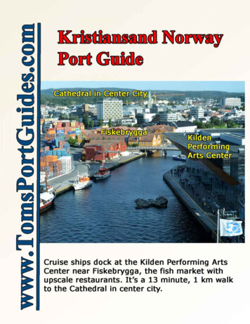
Toms Kristiansand Norway Cruise Port Guide1) Walking tour map from cruise ship dock to Fiskebrygga, the parks, Fortress, Center City Cathedral,shops, restaurants, etc. with photos & descriptions, 2) Walking tour map from the Fortress to BystrandaCity Beach, Aquarama Bad water sports complex, then along scenic parks next to the river and throughPosebyen area with 18th century old wooden houses to the Cathedral in Center City.Kristiansand is located on Norway’s idyllic southern coast (map atright). The city is surrounded by sea and fjords perfect for sailing andfishing and mountains ideal for hiking and skiing.Cruise ships dock near Fiskebrygga, the famous fish market withexcellent restaurants, cafes, an ice cream parlor, etc.Kristiansand is “ideal” for a walking tour There are many things to see and do: impressive architecture,colorful buildings, scenic parks, marinas, museums, a cathedral,excellent restaurants, cafes, coffee shops, ice cream shops, greatshopping, and more! Kristiansand has Northern Europe’s largestcollection of low, terraced, white, wooden houses dating back to the 18th and 19th centuries in thePosebyen area of Old Town.It’s a pedestrian friendly city with flat walkways no hills to climb nor steeply inclined streets. Streetsare laid out in a grid and street signs are prominently displayed so it’s easy to find your way.Walking distance is not very far. The city is a square measuring 0.5 mile by 0.6 mile. You can walk thefull distance north-south or east-west in about 10 to 12 minutes. The city is clean and safe.If you wish to minimize walking, there’s a Tractor Pulled Train and Segway rental next to the cruise ship dockto tour the city.Start your internet research for your shore excursion by reading:About Kristiansand – an excellent, comprehensive description of the city and area with sand/The official Kristiansand tourism website - excellent descriptions, photos, and outstanding hern-norway/kristiansand/Table of ContentsSubjectA city map showing the tourist attractions and the cruise ship dockGPS coordinates to plan your walk, restaurants at Fiskebrygga, the fish marketTractor pulled train and Segway rental next to the cruise shipTurn by turn walking route directions from the ship to the parksWalking route thru the parks to the FortressCenter City – the Cathedral, museums, restaurants, cafes, shops, etc.An optional walking tour from the Fortress through Posebyen to Center CityUser Feedback, Copyright Notice, Terms and Conditions for use of Toms Port GuidesPages2345-67-1213-1819-2223CAVEATInformation contained herein is believed to be accurate. PLEASE verify the information you use for your travelplans. Opinions expressed are my own. This port guide is protected by copyright law - see the last page of thisguide for legal notices.Tom SheridanKristiansand-10-31-2016Page 1 of 23 Copyright www.TomsPortGuides.com
Kristiansand City MapCruise ships dock next to the Kilden Performing Arts Center. My suggested walking route is shown as a dottedred line from the ship through the parks to the Fortress, the Center City area, and back to the ship. This route isis 1.7 miles and takes 34 minutes without stopping. Center city has a Cathedral, two museums, restaurants,shops, cafes, pubs, etc. See pages 19-22 of this guide for an optional walking route from the Fortress toBystranda City Beach, Aquarama Bad water sports complex, and Posebyen area with 18th C wooden houses.Kristiansand-10-31-2016Page 2 of 23 Copyright www.TomsPortGuides.com
GPS CoordinatesI provide GPS Coordinates so you can view details of the location on Google or Microsoft Bing maps at anymap scale on using “road”, “satellite”, “birdseye”, “earth”, or “terrain” maps. Create travel maps to take with you see http://www.tomsportguides.com/map-user-guide.html Program your hand held GPS, tablet, or phone with the GPS coordinatesThe format for GPS coordinates is Degrees, Minutes, and Seconds ddd mm' ss.ss” N ddd mm' ss.ss” ECopy and paste GPS coordinates from this guide into Google or Microsoft Bing maps or type the coordinates intothe map search box replacing the symbols for degrees, minutes, and seconds with spaces.For example: the Cruise Ship Dock has GPS coordinates of 58 08'17.6"N 7 59'48.6"EType 58 08 17.6 n 7 59 48.6 e into the map search box and press enter to see the Cruise Ship DockThe map below shows detail of the dock area – the place to start your walking tourKristiansand-10-31-2016Page 3 of 23 Copyright www.TomsPortGuides.com
Tractor Pulled Train 30 minute ride see http://citytrain.no/The City Train is 15 euros, 10 pounds, 15 USD, or 100 kr (Sept 2016 prices). The train goes past Fiskebrygga,the parks, the fortress, city beach. and through Posebyen to see the old wooden houses. The train tour ends inCenter City where you can get off to explore the area andthen walk 12 minutes 1 km back to the ship.Guided Segway Tours begin next to the Cruise ShipDock. The sign at left shows the prices in September2016. For more information, see www.segway-tours.noA Walking Tour of Kristiansand from the Cruise ShipBelow, I describe a step-by-step walking tour withphotos, and maps of the route and descriptions of touristsites.The route I recommend is along the harbor through theparks to the Fortress. From the Fortress, I walk to theCathedral along Kirkengata. After exploring the centercity area, I walk back to the ship on Markens Gate andwalk back to the ship. There are several other streets youcan use to/from center city.It’s a very scenic walk with many things to stop andphotograph.I did not walk to Posebyen to see the old wooden houses.However, I describe the area in detail in this guide.Kristiansand-10-31-2016Page 4 of 23 Copyright www.TomsPortGuides.com
The starting point for the walk is the Cruise Ship Dock at GPS 58 08'17.6"N 7 59'48.6"EWalk from the ship along the water in front of the The Kilden Performing Arts Centre.The centre provides artistic experiencefor the whole region for generations tocome.The goal is to create experiences for lifeby taking a broad-based approach andachieving a reputation as an importantarena for arts and culture. At the sametime, as a building and institution,Kilden, radiates grandeur, pride andsense of ilden/Velkommen-til-ossWhen you reach the north corner of the Kilden Performing Arts Centre (photo below), you will seeFiskebrygga, the fish market, on your left.Cross the street. Fiskebrygga will be on your your left. (Photo below)Kristiansand-10-31-2016Page 5 of 23 Copyright www.TomsPortGuides.com
Fiskebrygga, the fish market, is a must visit site. It’s a scenic boat basin surrounded by restaurants andstands selling beer and drinks. The food, local beer, drinks, and ice cream are great! There’s a foot bridge tocross the canal as shown in the photo below.Note: Most restaurants open mid to late day. Other than taking photos, there isn’t much to do in the morning.It’s probably best to visit Fiskebrygga on your way back to the ship in the afternoon.Immediately past Fiskebrygga, you’ll see a bridge in front of you. Walk across the bridge as shown by theyellow arrow in the photo below. Be sure to stop on the bridge for photos of the Marinas.At the end of the bridge, turn rightto the path through the parks asshown by the yellow arrow on thephoto at right.To locate the end of the bridge onGoogle maps, search for58 08'30.9"N 7 59'48.5"EGoogle shows the location of theGPS as a down pointing red arrowon the map.I have marked up a Google map onthe next page to show the walkingpath to the Fortress.Kristiansand-10-31-2016Page 6 of 23 Copyright www.TomsPortGuides.com
A down-pointing red arrow on the Google map above shows where you step off the bridge onto thewalking path thru the parks. Take time to explore the parks. Enjoy all the sculpture and the whimsical,“fun” works of art designed to be enjoyed by children and people of all ages.Google estimates it’s a 13 minute, 1.2 km walk from Kildens Performing Arts Center to the Fortress.The parks and marinas are close to center city. Please note these streets: Ostre Strandgate is the major north-south street on the edge of the city. Markens Gate is the major cross street in the city for shopping, restaurants, bars, etc. Kirkegata is the cross street into the city to the front of the Cathedral in Center City.Kristiansand-10-31-2016Page 7 of 23 Copyright www.TomsPortGuides.com
View from the bridge approaching the park (photo below)Sculpture in the park – there’s a lot to seeKristiansand-10-31-2016Page 8 of 23 Copyright www.TomsPortGuides.com
Statues and Sand CastlesA Fountain in the parkKristiansand-10-31-2016Page 9 of 23 Copyright www.TomsPortGuides.com
Sjøhuset Restaurant (photo below) has been a landmark among Kristiansand's finest restaurants for twodecades. The menu includes fish and shellfish of supreme quality, lobster, reindeer meat, lamb, etc. It’s ahighly rated, popular, and expensive restaurant with great views of the harbor. Open 15.00-23.00. From Aprilopen from 11.00. GPS 58 08'32.5"N 7 59'57.0"E See http://www.sjohuset.no/Christiansholm Fortress (photo below) GPS 58 08'38.9"N 8 00'12.6"EThe fortress was built by Fredrik III in 1672 to guard the coastline entering the city. The rotunda walls are fivemeters (16 feet) thick. It’s open from 15 May to 15 September, 09.00-21.00. Entry was free when I visited it inSeptember 2016. The fortress is used for weddings and other functions.Kristiansand-10-31-2016Page 10 of 23 Copyright www.TomsPortGuides.com
There’s a spiral staircase to climb to the top of the Fortress for scenic views of the area (photo below)One of the cannons at the fortress (photo below)Kristiansand-10-31-2016Page 11 of 23 Copyright www.TomsPortGuides.com
View from the Fortress (photo below)I did not climb the spiral staircase of the Rotunda. I wish I had because the views of the city and harbor must bebeautiful from that perspective. I would recommend climbing the stairs to the top of the Rotunda for photos.When you are done exploring the park area,walk to center city.The street along the edge of the park is OstreStrandgate. From Ostre Strandgate, you caneither turn on Kirkegata and walk directly tothe Cathedral or take Markens Gate to thearea just south of the Cathedral.Markens Gate is the main street in center cityfor shopping, restaurants, cafes, coffee shops,banks, etc.I walked Kirkegata to the Cathedral andreturned to the ship on Markens Gate.The photo at right is at the corner of OstreStrandgate and Kirkegata.GPS 58 08'39.3"N 7 59'57.3"EKristiansand has many impressive buildings.Kristiansand-10-31-2016Page 12 of 23 Copyright www.TomsPortGuides.com
Map of Center City KristiansandThis map shows the Tourist Information Office, banks, some of the most popular restaurants, two museums, the Cathedral, and the Commune. Spendtime exploring Center City area. Be sure to walk North-South on Markens Gate to visit the shops, restaurants, cafes, coffee shops, pubs, etc. Asection of Markens Gate is closed to traffic in center city for the convenience of pedestrians.Kristiansand-10-31-2016Page 13 of 23 Copyright www.TomsPortGuides.com
Sorlandets Kunstmuseum (Art Museum) GPS 58 08'48.5"N 7 59'37.6"EThe exhibits include paintings and sculpture. It’s a place for art lovers.Hours: Tuesday – Saturday 11am – 5pm Sunday 12pm – 4pm Monday ClosedAdult admission: 60 Norwegian Krone 8 USDSee http://skmu.no/english/Kristiansand Kunsthall - Art GalleryKristiansand Kunsthall is one of the largest and most spectacular locations for Norwegian andinternational contemporary art in Southern Norway. It’s located on the top level of The Public Librarynext to the Cathedral. The gallery presents changing exhibitions of guided tours for groups byappointment, adapted teaching program for children and youths in separate workshops.Admission is free. Hours are 12-16 Tuesday-Sunday, closed on Monday.There are many artists in Kristiansand. The Kristiansand Kommune is for visiting d-kommune GPS 58 08'42.7"N 7 59'47.3"EThe City of Kristiansand offers a residency to professional artists, preferably, fine artist and craft artists.The aim is to strengthen, promote and develop collaboration and network between contemporary artistsin Kristiansand and other national and foreign artists and to enrich the cultural stage of our town.The apartment is situated in the centre of Kristiansand not far from Posebyen, the city’s charming oldquarter with white wooden houses. The apartment is approx. 80 square m and is situated on the secondfloor. It has a kitchen, living room, bathroom, 2 bedrooms attached together and a small studio. It ispossible for two artists to stay together if that is desirable. It is equipped with essential furniture, linenand towels, cooker, refrigerator and kitchenware. In addition to two single-beds, the apartment isprovided with a sofa bed. Artists can stay for 3 months.Photo of buildings on Radhusgata across the street from the CathedralKristiansand-10-31-2016Page 14 of 23 Copyright www.TomsPortGuides.com
Major street and building renovation in center city near the Cathedral.When I visited Kristiansand in September 2016, the streets in front of the Cathedral and the entire block ofbuildings south of the Cathedral had been torn down.GPS Coordinates for the Cathedral 58 08'46.1"N 7 59'40.8"EKristiansand-10-31-2016Page 15 of 23 Copyright www.TomsPortGuides.com
There’s a garden next to the Cathedral with a statue ofJonathan C. Heuch (photo at left). He was a popularbishop, a Commander, First Class of the Royal NorwegianOrder of St. Olav from 1896, and held the Grand Cross ofthe Swedish Order of the Polar Star.Building facades near the Cathedral were being held inplace while the entire building interior is torn down andrebuilt. Photo BelowMajor construction in center city is not a problem fortourists. There were well marked, clean, and safepaths around the construction sites. Most important,all the restaurants, shops, etc. were open for businessas usual. The Cathedral was open.The fact that some buildings had been leveled made it easier to take photos of sites which would normally bedifficult to photograph.Hos Naboen restaurant at the corner of Markens Gate and Radhusgata see http://hosnaboen.no/Kristiansand-10-31-2016Page 16 of 23 Copyright www.TomsPortGuides.com
List of some of the popular restaurants with their websites and GPS CoordinatesHos Naboen Markens Gate & Radhusgata http://hosnaboen.no/Patricks Pub Markens Gate 10http://mat-uteliv.no/patricksFood Asylum Japanese Markens Gate 9 http://www.foodasylum.com/Gastropuben på Kick Dronningens Gate 8 http://www.gastropuben.no/Slakter Sorensen Markens Gate 8 http://mat-uteliv.no/slakter-soerensenMother India Markens Gate 6http://motherindia.no/GPSGPSGPSGPSGPSGPS58 08'43.0"N 7 59'36.4"E58 08'40.4"N 7 59'43.4"E58 08'38.5"N 7 59'45.3"E58 08'38.0"N 7 59'43.2"E58 08'40.6"N 7 59'43.2"E58 08'39.2"N 7 59'45.6"EThe location of these restaurants is shown on the map on page 13.Patricks Irish PubSlakter SorensenKristiansand-10-31-2016Page 17 of 23 Copyright www.TomsPortGuides.com
Sandens is a women’s store with 35 shops on three floors. See the photo of the interior below.Street view of Sandens (photo below)McDonalds is an impressive building (photo below)Kristiansand is a beautiful, incredibly clean city withimpressive architecture.There are a variety of places to visit, shop, have a mealor drink, and relax.Plan on spending time in center city.Kristiansand-10-31-2016Page 18 of 23 Copyright www.TomsPortGuides.com
PosebyenPosebyen is an area in Kristiansand with the longest, continuous collection of wooden houses in northern Europe. The map below shows thesuggested walking route (red dotted line) from the Fortress to the Brystanda City Beach, past Aquarama Bad, along the scenic river, turning left ontoSkippergata through the Posebyen area to Radhusgata and turning left onto Radhusgata for two blocks to the Cathedral in center city.For reference, the walking route from the ship to the Fortress to the Cathedral in Center City and back to the ship is 1.7 miles and takes 34 minuteswithout stopping. Adding Posebyen to your walking tour from the Fortress will add a minimum of 0.8 miles and 16 minutes to your walk “withoutstopping”. You could walk up-down all the streets in Posebyen. At minimum, walk along Skippergata, the route taken by the City Train.“Technically”, Posebyen includes two streets to the left of the yellow outlined area on this map. I did not include them because the concentration ofwhite houses is in the area outlined by yellow lines.Kristiansand-10-31-2016Page 19 of 23 Copyright www.TomsPortGuides.com
How to use Google maps to explore Posebyen from your home computer, before your cruise.Google maps are incredibly powerful to study and “see” the city. Open a Google “Earth” map and change theangle of view to see all the white wooden houses in Posebyen by changing to a 3D tilted view.The 3D view allows you to see the landscape from almost any angle – note the white wooden houses.Here is a 3D tilted map view of the houses on Skippergata near Elvegata street.Kristiansand-10-31-2016Page 20 of 23 Copyright www.TomsPortGuides.com
Experiment with 3D views to see not only the houses but also hills in the background of the city.I entered GPS coordinates of 58 09'01.1"N 7 59'57.5"E into a Google map search box and pressed theenter key. Then I switched to “Earth” map and clicked on “3D” to tilt the map. I used the Ctrl key withthe mouse to rotate the map and tilt it very low so that I could see the mountains in the background.Below is the resulting Google Earth 3D, tilted, and rotated view of the house on Skippergata.This is an excellent way to study the landscape and explore the port area.In addition to earth views, Google has street level photos. These photos are limited to public streets becauseGoogle takes the photos by driving cars on public streets with a bank of cameras on the roof.To access the street level photos, drag the little yellow man icon from the bottom right of thescreen onto the Google map. The streets with street level photos will be shown with a blue linedown the center of the street.Place the little yellow man icon onto one of the blue lines in the streets. The screen will dividewith a street level photo on the top and a map view of the area on the bottom. Move the yellow man icon downthe street to see what you would see if you were walking or driving on that street. Rotate the icon to see theviews in different directions. The Google street level images are reasonably good quality.I use this technique on my home computer “before” I visit a port to decide where I want to walk and where thebest photos opportunities are. In a few minutes, I was able to preview the Posebyen area. I had planned to walkto Posebyen, but I spent a lot of time at Fiskebrygga, in the park area near the Fortress, and wanted to focus oncenter city, so I decided to cancel my visit to the Posebyen area.If I had visited it, I would have concentrated on Skippergata and Radhusgata streets in Posebyen. These streetshave some of the best examples of the old, white wooden houses.Kristiansand-10-31-2016Page 21 of 23 Copyright www.TomsPortGuides.com
Search Google maps for 58 09'01.1"N 7 59'57.5"E then drag the little yellow man onto the map and place it at the down-pointing red arrow.Rotate the yellow man icon to this street level photo as shown below. Google shows this street level photo was taken in June 2014 at 106Skippergata in Kristiansand. The second house from the corner at Elvegata is 131 Skippergata. It has a green front door.Street level photos have two, independent screens. The upper screen is the street level photo. Use the mouse to change the horizontal and verticalangle of view of the photo. You can also change magnification of the photo.The street map screen is below the photo and can be moved independent of the photo. Click on the icon on the left lower corner to make the mapscreen fill the full width of the viewing area. Click on the and – bars on the right side of map to change magnification of the street map.The location of the street level photo is shown on the map by the location of the little yellow man icon and the arrow at his feet shows the directionhe is facing as if the little yellow man icon were taking the photo. Click anywhere on the street map to see the photo that location.Kristiansand-10-31-2016Page 22 of 23 Copyright www.TomsPortGuides.com
User Feedback Is WelcomeGoalMy guides are designed to help you plan a great cruise vacation by providing information such as where theship docks, location of tourist sites, public transit, walking tour maps, things to see and do, travel issues uniqueto the port, etc. Knowledge of ports is important when planning shore excursions because you have to makemany decisions and commitments long before your ship docks. I believe the information in this guide isaccurate, however you are responsible to verify accuracy of the information that you use to plan your vacation.Information on cruise ports frequently changes such as bus routes, admission fees to sites, rental car locations,etc. Cruise Critic is the best source for up-to-date, detailed information on travel details for shore excursions,reviews of cruise ships, etc. There are many knowledgeable people on Cruise Critic who are willing to sharetheir expertise and travel experience. I highly recommend www.CruiseCritic.com; it's free to join.Why feedback is importantUser feedback helps me make corrections and improve the format and content in my quest to produce the“ultimate” port guides. I welcome offers to collaborate with me or provide materials for use in my guides.PLEASE Help “spread the word” about my websiteThe only negative feedback I get is, “I wish I knew about your port guides before my vacation”. Please tellyour friends and post a reference to my guides and website on the blogs. To receive email notification whennew guides are available, send your email address to me at TomsPortGuides@gmail.comCopyright Notice & Terms and Conditions for Use of My GuidesMy port guides and everything on my website www.TomsPortGuides.com is copyrighted by Thomas Sheridanwith all rights reserved, and protected by international copyright laws.PERMITTED USE: Personal, non-commercial use of my port guides and/or material from my website.I allow individuals to take my guides apart for personal, non-commercial use. Many cruisers carry a map or afew pages from my guide on a shore excursion. That's OK. I also allow people to post my guides on websitesthey set up for fellow travelers to share information on shore excursions such as the websites set up by CruiseCritic members for the Roll Calls. That's OK. My guides are for use and enjoyment of individual travelers.PROHIBITED USE of my port guides and/or material from my website.NO person, company, organization, website, etc. is permitted to use material from my website for a commercialpurpose, to sell, require a membership to download my port guides, or use any of my copyrighted material for acommercial purpose.NO person, company, organization, website, etc. is permitted to distribute excerpts from my guides or materialfrom my website as electronic, digital, or paper copies. My Port Guides must be kept intact, as downloadedfrom my website, with this copyright notice.NO Cruise Ship employee, representative, contractor, port lecturer, etc. is permitted to distribute excerpts frommy guides or material from my website as electronic, digital or paper copies. My Port Guides must be keptintact, as downloaded from my website, with this copyright notice. A blatant example of violation of mycopyright was a cruise ship docked in Copenhagen where the shore excursion desk personnel removed mapsfrom my guide, removed my name as the copyright owner, and copied/distributed my maps.Fortunately, a friend of mine on that ship complained to the purser and the ship stopped violating my copyright.If there is any question about use of my guides, contact me at TomsPortGuides@Gmail.comTom SheridanKristiansand-10-31-2016Page 23 of 23 Copyright www.TomsPortGuides.com
Guided Segway Tours begin next to the Cruise Ship Dock. The sign at left shows the prices in September 2016. For more information, see www.segway-tours.no A Walking Tour of Kristiansand from the Cruise Ship Below, I describe a step-by-step walking tour with photos, and maps of the route and descriptions of tourist sites.