Transcription
United StatesDepartmentof AgricultureNaturalResourcesConservationServiceIn cooperation with theFairbanks Soil andWater ConservationDistrict; AlaskaDepartment of NaturalResources, Division ofAgriculture, Division ofForestry, Division ofGeological andGeophysical Surveys,and Division of Land;Fairbanks North StarBorough; Tanana ChiefsConference, Inc.; City ofFairbanks; U.S. ArmyCorps of Engineers,Chena Lakes FloodControl Project; AlaskaCooperative Extension;University of AlaskaFairbanks, Agriculturaland Forestry ExperimentStationSoil Survey ofGreater FairbanksArea, Alaska
3How To Use This Soil SurveyDetailed Soil MapsThe detailed soil maps can be useful in planning the use andmanagement of small areas.To find information about your areaof interest, locate that area on theIndex to Map Sheets. Note thenumber of the map sheet and turnto that sheet.Locate your area of interest onthe map sheet. Note the map unitsymbols that are in that area. Turnto the Contents, which lists themap units by symbol and nameand shows the page where eachmap unit is described.The Contents shows which tablehas data on a specific land use foreach detailed soil map unit. Alsosee the Contents for sections ofthis publication that may addressyour specific needs.
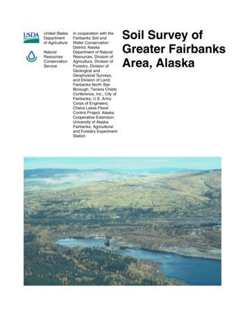
4This soil survey is a publication of the National Cooperative Soil Survey, a joint effort ofthe United States Department of Agriculture and other Federal agencies, State agenciesincluding the Agricultural and Forestry Experiment Station, and local agencies. TheNatural Resources Conservation Service has leadership for the Federal part of theNational Cooperative Soil Survey.Major fieldwork for this survey began in 1996 and was completed in 2000. Unlessotherwise indicated, statements in this publication refer to conditions in the Survey Areain 2000. This survey was made for the Greater Fairbanks Area, Alaska by the NaturalResources Conservation Service; the Fairbanks Soil and Water Conservation District;Alaska Department of Natural Resources, Division of Agriculture, Division of Forestry,Division of Geological and Geophysical Surveys, and Division of Land; Fairbanks NorthStar Borough; Tanana Chiefs Conference, Inc.; City of Fairbanks; U.S. Army Corps ofEngineers, Chena Lakes Flood Control Project; Alaska Cooperative Extension; Universityof Alaska Fairbanks, Agricultural and Forestry Experiment Station.Soil maps in this survey may be copied without permission. Enlargement of thesemaps, however, could cause misunderstanding of the detail of mapping. If enlarged,maps do not show the small areas of contrasting soils that could have been shown at alarger scale.The United States Department of Agriculture (USDA) prohibits discrimination in all ofits programs and activities on the basis of race, color, national origin, sex, religion, age,disability, political beliefs, sexual orientation, and marital or family status. (Not allprohibited bases apply to all programs.) Persons with disabilities who require alternativemeans for communication of program information (Braille, large print, audio tape, etc.)should contact the USDA’s TARGET Center at 202-720-2600 (voice and TDD).To file a complaint of discrimination, write USDA, Director, Office of Civil Rights, Room326-W, Whitten Building, 1400 Independence Avenue, SW, Washington, D.C., 202509410, or call 202-720-5964 (voice and TDD). USDA is an equal opportunity provider andemployer.Cover: A typical landscape in the Greater Fairbanks Area. Mine tailings are in theforeground with Minto, Fairbanks, and Steese soils on the hills in the background.Additional information about the nation’s natural resources is available on theNatural Resources Conservation Service home page on the World Wide Web. Theaddress is http://www.nrcs.usda.gov.
5ContentsHow To Use This Soil Survey . 3Foreword. 9General Nature of the Survey Area . 11Geology . 11Climate. 12Forestry. 12Use and Management of Soils forAgriculture. 13Subsistence . 13Land Clearing . 13Adapted Crops. 13Irrigation. 13Fertilizer Requirements . 14How This Survey Was Made . 14Detailed Soil Map Unit . 15101—Bolio peat . 16102—Bradway very fine sandy loam . 16103—Chatanika mucky silt loam, 0 to 3percent slopes . 17104—Chatanika mucky silt loam, 3 to 7percent slopes . 17105—Chatanika mucky silt loam, 7 to 12percent slopes . 18106—Chatanika mucky silt loam, 12 to 20percent slopes . 18107—Chatanika-Goldstream complex . 19108—Chena very fine sandy loam . 19109—Dumps, landfill . 20110—Dumps, mine . 20111—Eielson fine sandy loam . 20112—Eielson-Piledriver complex. 21113—Eielson-Tanana complex . 21114—Ester peat, 20 to 45 percent slopes . 22115—Ester peat, very steep . 23116—Fairbanks silt loam, 3 to 7 percentslopes . 23117—Fairbanks silt loam, 7 to 12 percentslopes . 24118—Fairbanks silt loam, 12 to 20 percentslopes . 24119—Fairbanks silt loam, 20 to 30 percentslopes . 24120—Fairbanks silt loam, 30 to 45 percentslopes . 25121—Fairbanks silt loams, strongly slopingand steep . 25122—Fairbanks-Steese complex, 12 to 20percent slopes . 26123—Fairbanks-Steese complex, 20 to 30percent slopes . 27124—Fubar-Piledriver complex,occasionally flooded . 28125—Gilmore silt loam, 3 to 7 percentslopes. 28126—Gilmore silt loam, 7 to 12 percentslopes. 29127—Gilmore silt loam, 12 to 20 percentslopes. 29128—Gilmore silt loam, 20 to 30 percentslopes. 30129—Gilmore silt loam, 30 to 45 percentslopes. 30130—Gilmore silt loam, 45 to 70 percentslopes. 31131—Gilmore-Ester complex, 12 to 70percent slopes . 31132—Gilmore-Steese complex, 3 to 15percent slopes . 32133—Goldstream peat, 0 to 3 percentslopes. 33134—Goldstream peat, 3 to 7 percentslopes. 33135—Goldstream-Histels complex, 0 to 3percent slopes . 34136—Histels . 35137—Jarvis fine sandy loam . 35138—Jarvis-Chena complex . 36139—Jarvis-Salchaket complex . 36140—Lemeta peat . 37141—Liscum-Noonku complex. 38142—Minto silt loam, 0 to 3 percent slopes . 38143—Minto silt loam, 3 to 7 percent slopes . 39144—Minto silt loam, 7 to 12 percent slopes . 39145—Minto-Chatanika complex, 0 to 3percent slopes . 40146—Minto-Chatanika complex, 3 to 7percent slopes . 40147—Minto-Chatanika complex, 7 to 12percent slopes . 41148—Minto-Chatanika complex, 12 to 20percent slopes . 42149—Mosquito mucky peat . 43
6150—Mosquito-Noonku complex .43151—Noonku very fine sandy loam .44152—North Pole fine sandy loam .44153—North Pole-Mosquito-Liscum complex.45154—North Pole-Noonku complex .46155—Peede silt loam .47156—Peede-Mosquito complex .47157—Piledriver very fine sandy loam .48158—Piledriver-Eielson complex .48159—Piledriver-Fubar complex .49160—Pits, gravel.50161—Pits, quarry .50162—Riverwash .50163—Salchaket very fine sandy loam.50164—Salchaket-Typic Cryorthents complex.51165—Saulich peat, 3 to 7 percent slopes .51166—Saulich peat, 7 to 12 percent slopes .52167—Saulich peat, 12 to 20 percent slopes .52168—Saulich-Minto complex, 3 to 12percent slopes .53169—Saulich-Minto complex, 12 to 20percent slopes .54170—Steese silt loam, 3 to 7 percent slopes.54171—Steese silt loam, 7 to 12 percentslopes .55172—Steese silt loam, 12 to 20 percentslopes .55173—Steese silt loam, 20 to 30 percentslopes .56174—Steese silt loam, 30 to 45 percentslopes .56175—Steese silt loam, 45 to 70 percentslopes .57176—Steese-Gilmore complex, 12 to 20percent slopes .57177—Steese-Gilmore complex, 20 to 30percent slopes .58178—Steese-Gilmore complex, 30 to 45percent slopes .59179—Steese-Gilmore complex, 45 to 70percent slopes .60180—Tanacross peat.60181—Tanana mucky silt loam.61182—Tanana-Mosquito complex .61183—Typic Cryaquent, Histic Cryaquept,and Terric Cryofibrist soils.62184—Typic Cryorthents, pit spoil .63185—Typic Cryorthents-Urban landcomplex .63186—Urban land .64187—Water .64Soil Properties .65Engineering Index Properties.65Physical Properties .66Chemical Properties .67Water Features.68Soil Features .69Use and Management of the Soil .71Land Capability Classification .71Interpretive Ratings .72Rating Class Terms .72Numerical Ratings.72Forest Productivity .72Forest Management .72Engineering .73Building Site Development.73Sanitary Facilities .74Construction Materials .76Hydric Soils .77Key To Hydric Soil Criteria.78Classification of the Soils.79Taxonomic Units and Their Morphology .79Bolio Series .80Bradway Series .80Brigadier Series.81Chatanika Series .82Chena Series.83Eielson Series .84Ester Series.85Fairbanks Series .85Fubar Series.86Gilmore Series.87Goldstream Series .88Histels.89Histic Cryaquepts .89Jarvis Series.90Lemeta Series .91Liscum Series.92Minto Series .92Mosquito Series.93Noonku Series.94North Pole Series .95Peede Series.96Piledriver Series .97Salchaket Series .98Saulich Series .99Steese Series .99Tanacross Series .100Tanana Series .101Terric Cryofibrists .102
7Typic Cryaquents. 103Typic Cryorthents. 104Formation of the Soils . 105References. 107Glossary. 109Tables. 119Table 1.—Temperature and Precipitation atFairbanks, Alaska . 120Table 2.—Probability of Frost at Fairbanks,Alaska . 121Table 3.—Growing Season at Fairbanks,Alaska . 121Table 4.—Acreage and Proportionate Extentof the Area . 122Table 5. Engineering Index Properties . 124Table 6. Engineering Sieve Data. 134Table 7. Physical Properties of the Soils . 145Table 8. Chemical Properties of the Soils . 155Table 9. Water Features. 165Issued 2004Table 10. Soil Features . 177Table 11. Land Capability . 183Table 12. Forest Productivity. 188Table 13. Forestland Management: ErosionHazard, Road Limitations . 196Table 14. Building Site Development:Structures . 206Table 15. Building Site Development: SiteImprovements . 219Table 16. Sanitary Facilities: SewageTreatment . 231Table 17. Sanitary Facilities: Landfill . 248Table 18. Construction Materials: Graveland Sand . 261Table 19. Construction Materials: Topsoiland Roadfill . 269Table 20. Hydric Soils List . 281Table 21. Classification of the Soils. 295
9ForewordThis soil survey contains information that can be used in land-planning programsin the Greater Fairbanks Area, Alaska. It contains predictions of soil behavior forselected land uses. The survey also highlights limitations and hazards inherent inthe soil, improvements needed to overcome the limitations, and the impact ofselected land uses on the environment.This soil survey is designed for many different users. Farmers, ranchers,foresters, and agronomists can use it to evaluate the potential of the soil and themanagement needed for maximum food and fiber production. Governmentagencies, community officials, Alaska Native tribes, engineers, developers,builders, and home buyers can use the survey to plan land use, select sites forconstruction, and identify special practices needed to ensure proper performance.Conservationists, teachers, students, and specialists in recreation, wildlifemanagement, waste disposal, and pollution control can use the survey to helpthem understand, protect, and enhance the environment.Various land use regulations of Federal, State, and local governments mayimpose special restrictions on land use or land treatment. The information in thisreport is intended to identify soil properties that are used in making various landuse or land treatment decisions. Statements made in this report are intended tohelp the land users identify and reduce the effects of soil limitations on various landuses. The landowner or user is responsible for identifying and complying withexisting laws and regulations.Great differences in soil properties can occur within short distances. Some soilsare seasonally wet or subject to flooding. Some are shallow to bedrock or topermafrost. Some are too unstable to be used as a foundation for buildings orroads. Wet soils are poorly suited to use for waste treatment systems. A high watertable makes a soil poorly suited to basements or underground installations.Many soil properties that affect land use are described in this soil survey. Thelocation of each soil is shown on the detailed soil maps. Each soil in the surveyarea is described. Information on specific uses is given for each soil. Help in usingthis publication and additional information is available at the Fairbanks office of theNatural Resources Conservation Service or Alaska Cooperative Extension.Shirley GammonState ConservationistNatural Resources Conservation Service
11Soil Survey of theGreater Fairbanks Area, AlaskaBy Dennis Mulligan, Natural Resources Conservation ServiceFieldwork by Dennis Mulligan, David K. Swanson, Mike Mungoven, David A.Puetz, Amber Williams, Erin Schneider, and Adam Hill, Natural ResourcesConservation ServiceUnited States Department of Agriculture, Natural Resources Conservation Service,in cooperation with the Fairbanks Soil and Water Conservation District; AlaskaDepartment of Natural Resources, Division of Agriculture, Division of Forestry,Division of Geological and Geophysical Surveys, and Division of Land; FairbanksNorth Star Borough; Tanana Chiefs Conference, Inc.; City of Fairbanks; U.S.Army Corps of Engineers, Chena Lakes Flood Control Project; AlaskaCooperative Extension; and the University of Alaska Fairbanks, Agricultural andForestry Experiment StationGeneral Nature of the Survey AreaThe Greater Fairbanks Area is in the interior ofAlaska (Figure 1). The survey area is approximately257,703 acres (104,370 h) in size. The populationcenter of the survey area is the city of Fairbanks,which is also the commercial hub of interior andnorthern Alaska and the second largest city in thestate.The Greater Fairbanks Area lies within two MajorLand Resource Areas: the Interior Alaska Highlandsand the Interior Alaska Lowlands. The InteriorAlaska Lowlands portion of the survey area includesthe broad, level flood plain that boarders the TananaRiver and its main tributary in this area, the ChenaRiver. Riverine features dominate the landscape andinclude meandering streams, sloughs, and oxbowlakes. The Interior Alaska Highlands portion of thesurvey area consists mostly of low mountains anddissected hills interrupted by flat-bottomed valleys.Slopes are generally steep. Usually, gently slopingalluvial fans lie between the Highlands’ hills and theLowlands’ flood plain, but in many places thetransition between the level flood plain and steephills is abrupt.Figure 1.—Location of Greater Faribanks Area in Alaska.GeologyThe Tanana River valley is a structural basinbetween the Alaska Range on the south and the
12Interior Alaska Highlands on the north. Much of thefloor of this basin is below sea level and covered by330 to almost 660 feet (100 to almost 200 m) ofQuaternary fluvial and glaciofluvial sedimentsprimarily from the Alaska Range. The history ofthese deposits relate to glacial advances fromIllinoian to Wisconsin times. The glaciofluvial sandand gravel are covered with finer sediments andorganic material of varying thickness. Thesedeposits are saturated with water, in most placesbelow the depth of observation for this survey (6 ft.or 2 m) but occasionally within a foot or two of thesurface. Permafrost is present in the basin andcovers approximately one-third to one-half of thearea. Elevations in the Tanana River valley rangefrom about 400 to 475 feet (121 to 144 m) abovesea level.Elevations in the Interior Alaska Highlands rangefrom about 450 to 2,006 feet (136 to 610 m).Geologic materials consist of weathered bedrockcovered with windblown silt (loess). Thepredominant bedrock in the area is highly deformedPaleozoic and Precambrian schist. The schist ishighly weathered and fractured near the surface withlocal intrusions of igneous rocks that are mainlygranite, quartz, diorite, and basalt. The loess is onlyabout a foot or two thick ( 1 m) on most hilltops andupper slopes. It may be many feet thick on hillsnearest the Tanana River and on the lower slopes ofhills elsewhere where the loess has been erodedfrom the hillsides and has accumulated on lowerslopes and in narrow upland valleys. Permafrost ispresent on lower slopes, valley bottoms, and northfacing slopes. Large bodies of ground ice arepresent in the thick silty deposits on lower slopesand valley bottoms. Periglacial features such aspingos, thermokarst pits and mounds, ice wedgepolygons, and beaded streams dominate theselower slopes and upland valleys.ClimateThe survey area has a continental subarcticclimate with long, cold winters and short, warmsummers. Summer (June, July, and August)temperatures average 58 degrees F (15 degrees C).Winter (November through March) temperaturesaverage 0.5 degree F (-18 degrees C). Extremesummer temperatures may exceed 90 degrees F (32degrees C) while extreme winter temperatures maydip below -60 degrees F (-51 degrees C). Theaverage annual precipitation is 12 inches (30 cm),with July and August on average the wettest monthsand April the driest. Snow covers the groundcontinuously from October to late April or early May.Soil Survey ofTables 1, 2, and 3 give a detailed summary ofclimatic data.ForestryThe forest types in the Greater Fairbanks Areaare a mosaic of patterns related to fire history, slopeand aspect, and the presence or absence ofpermafrost. Forest stands are classified by thedominant species, but most are a mixture of two ormore species.The forest vegetation pattern of this area iscomplex. Forests of white spruce, paper birch, andaspen dominate lower slopes and most south-facingslopes. Black spruce forests typically grow at higherelevations on north-facing slopes and at lowerelevations in areas where drainage is impeded.The white spruce forests of interior Alaska arethe best developed and most productive forests ofthis region. They have a minor component of paperbirch and balsam poplar and, on the best sites, treeswill be 98 feet (30 m) in height and 35 inches(90 cm) in diameter. Tree densities may be as highas 9,800 to 12,000 per acre (4,000 to 5,000/h) inyounger stands but are typically between 1,400 and2,400 per acre (600 and 1,000/h) in older stands.Where the canopy is closed an alder and willowshrub layer can be found. Common smaller shrubsfound in the white spruce forests are bog blueberry,crowberry, lingonberry, Labrador tea, and dwarfbirch. White spruce forests can regenerate after afire but often are the result of a successional changefrom hardwood pioneering species such as paperbirch and aspen. The white spruce forests haveeconomic importance in terms of supplying local sawmills with timber and providing home building logsfor the area.Paper birch forests are found on better-drained,usually silty-textured soils. These forests aretypically a result of fires and will usually be replacedthrough succession by white spruce or black spruceforests. Trees range from 59 to 82 feet (18 to 25 m)in height and up to 18 inches (45 cm) in diameter.Tree densities range from 15,000 trees per acre(6,000/h) in younger stands to 400 trees per acre(160/h) in mature stands. Common shrubcomponents are alder and highbush cranberry.Lingonberry and twinflower are common groundcovers, as is Canada bluejoint if stocking density islow.Black spruce forests dominate wetter and coldersites. The trees may attain a height of 30 feet (9 m)with a diameter of 4 inches (10 cm) in the course of100 years. These are low productivity sites withyoung stocking densities up to 15,000 trees per acre
Greater Fairbanks Area, Alaska(6,000/h) and mature densities that may be as highas 10,000 trees per acre (4,000/h). Shrubsassociated with black spruce forests are alder,willow, and Labrador tea. Sphagnum and clubmosses with some crowberry, lingonberry, and bogblueberry dominate ground cover.Aspen forests and balsam poplar forests are alsofound in the Greater Fairbanks Area. These forestsoften grow in areas of relatively recent soildisturbance, such as flood plains or areas subjectedto hot intense fires.Use and Management of Soils forAgricultureSoils have a wide range of characteristics thatinfluence their potential for agricultural development.A thorough understanding of soil properties canensure maximum agricultural benefits whilepreserving the integrity of the resource base.Woodland covers most of the soils in the surveyarea. Some of these soils are suitable for clearingand development for pasture, hay, and cool seasonrow crops. North-facing slopes are generally notsuitable for agricultural development because theylack sun exposure and tend to be colder. They mayalso settle unevenly after clearing because ofpermafrost. Ridge tops generally have good sunexposure but the soils tend to be shallow and acidic.Erosion control practices are required on ridges andsouth-facing slopes to maintain productivity. Leveland nearly level ground may be suitable foragriculture unless it is subject to frequent flooding orhas a high water table. Some permafrost soils canbe developed for agriculture but other permafrostsoils may settle unevenly and be subject tothermokarst. The local offices of the NaturalResources Conservation Service or AlaskaCooperative Extension can provide guidance on thesuitability of particular soils for crop production.SubsistenceThe Greater Fairbanks Area has a tradition ofsubsistence use of the native plant community.Harvesting of native plants for food, medicine, fiber,and fodder is an important land use. Whendeveloping land for agricultural production, considermanaging a portion of the land for berry, birch barkor syrup production or as a wood lot. For moreinformation about the use of native plants, consultlocal Alaska native groups, Alaska CooperativeExtension, or other ethnic organizations.13Land ClearingThe University of Alaska Cooperative ExtensionService publication Efficient Land ClearingTechniques (Colla and Southwick, 1987), describesmethods for clearing land. The Fairbanks Soil andWater Conservation District or the NaturalResources Conservation Service can assist farmersin developing a plan for bringing land intoproduction. These offices can also provideinformation on appropriate land clearing andbreaking techniques and the suitability of soils forspecific crops. They can also provide referrals tofederal, state, and local agencies for information onregulations affecting land clearing and removal ofclearing debris.Adapted CropsCrops that will grow in cool climates with longsummer days are best suited for this area. New cropvarieties are released every year and changes invarieties, farming practices, and markets affect whatcrops are grown in the area. Historically grass hayhas been a staple crop. Spring seeded small grainsare grown for livestock feed and humanconsumption. Grass for seed, legumes such as fieldpeas, and cool season vegetables have beensuccessful crops. Potatoes for both seed and tableare also grown and exported. Small fruits andspecialty crops have potential for the area,particularly for niche markets. The AlaskaCooperative Extension can provide information andadvice on suitable crop varieties and productiontechniques. The Alaska Division of Agriculture hasinformation regarding marketing and production ofagricultural products and the Alaska AgriculturalStatistics Service can provide crop yield data andproduction trends.IrrigationFairbanks has an average annual precipitation ofonly 10 to 13 inches (25 to 33 cm). Irrigation willim
in 2000. This survey was made for the Greater Fairbanks Area, Alaska by the Natural Resources Conservation Service; the Fairbanks Soil and Water Conservation District; Alaska Department of Natural Resources, Division of Agriculture, Division of Forestry, Division of Geological and Geophysical Surveys, and Division of Land; Fairbanks North