Transcription
GREAT WESTERN HIGHWAY UPGRADE,MOUNT VICTORIA TO LITHGOW ALLIANCEFORTY BENDS UPGRADE – REVIEW OF ENVIRONMENTAL FACTORSTECHNICAL PAPER 5NOISE AND VIBRATIONOCTOBER 2012
Great Western Highway Upgrade, Mount Victoria to Lithgow AllianceForty Bends Upgrade REFTechnical Paper 5: Noise and VibrationContentsGlossaryvExecutive oposal descriptionPurpose of this studyStudy areaExisting noise environment52.1.2.2.2.3.578Receiver locationsNoise monitoringTraffic noise descriptorsRegulatory requirements113.1.3.2.3.3.3.4.11131315Operational noise criteriaMaximum noise level assessment – sleep disturbanceConstruction noise criteriaConstruction vibration criteriaOperational noise assessment194.1.4.2.4.3.4.4.19232526Assessment parametersNoise modelling resultsMaximum noise level assessmentOperational mitigationConstruction noise and vibration295.1.5.2.2931Construction programConstruction noise and vibration assessment6.Summary and conclusions417.References43NV-0684-C.docPage iii
Great Western Highway Upgrade, Mount Victoria to Lithgow AllianceForty Bends Upgrade REFTechnical Paper 5: Noise and VibrationList of TablesTable 2-1 Monitoring locations – unattended noise survey7Table 2-2 Summary of monitoring results - environmental noise descriptors8Table 2-3 Summary of monitoring results - traffic noise descriptors8Table 3-1: Road traffic noise base criteria12Table 3-2 General construction noise management levels (NML’s)14Table 3-3 Calculated noise level goals for construction work15Table 3-4 Recommended standard hours for construction work15Table 3-5 Preferred and maximum weighted rms values for continuous and impulsive vibrationacceleration (m/s2) 1-80Hz16Table 3-6 Acceptable VDV for intermittent vibration (m/s2)16Table 3-7 BS 7385 Structural damage criteria17Table 3-8 DIN 4150-3 Vibration Guidelines for Heritage Buildings17Table 3-9 Summary of project vibration criteria18Table 4-1: Factors affecting road traffic noise19Table 4-2 AADT data input to noise model for the year (2015)20Table 4-3 AADT data input to noise model for the year (2025)21Table 4-4 ADT calibration data for the year (2012)21Table 4-5 Comparison of measured and modelled road traffic noise levels22Table 4-6 Predicted noise levels24Table 5-1 Construction activities and timing30Table 5-2 Summary of project construction equipment32Table 5-3 Predicted noise levels from construction activities33Table 5-4 Construction traffic35Table 5-5 Estimated vibration impacts – vertical axis36Table of FiguresFigure 1-1 Study Area4Figure 2-1 Heritage items6Figure 4-1 Maximum noise events by the hour25Figure 4-2 Distribution of maximum noise events during the night26Appendix A -Noise contoursAppendix B -Noise logger graphsNV-0684-C.docPage iv
Great Western Highway Upgrade, Mount Victoria to Lithgow AllianceForty Bends Upgrade REFTechnical Paper 5: Noise and VibrationGlossaryA description of acoustic related terms used in this report is given below.Monitoring terminology dB(A): A unit of sound measurement which has frequency characteristics weighted so that itapproximates the response of the human ear to sound waves.LA10: Descriptor used to define noise level which is exceeded 10 per cent of the time and isoften described as the average of maximum noise levels.L A10 (18hr): Is the arithmetic average of the L 10(1hr) levels for the 18-hour period between0600 and 2400 hours on a normal working day.LA90: Is the noise level that is exceeded 90 per cent of the measurement time. Thisparameter is commonly referred to as the background noise level.RBL: Rating Background Level is the overall single figure LA90 background levelrepresenting each assessment period over the whole monitoring period. The RBL is usedfor determining the appropriate construction noise criteria.LAeq: Noise level that represents the energy average noise from the source during aspecified time period, and is the equivalent continuous sound pressure level for a givenperiod LAeq(15hr): The Leq noise level for the period from 7 am to 10 pm. LAeq(9hr): The Leq noise level for the period from 10 pm to 7 am.Traffic terminology Heavy Vehicle: A truck, transport or other vehicle with a gross vehicle weight above aspecified level (for example: over 8 tonnes).Noise barrier: Generally a wall or an earth mound that obstructs or restricts the passage ofsound from a noise source.Road terminology DGAC: Dense Grade Asphaltic Concrete OGAC: Open Grade Asphaltic ConcreteNV-0684-C.docPage v
Great Western Highway Upgrade, Mount Victoria to Lithgow AllianceForty Bends Upgrade REFTechnical Paper 5: Noise and VibrationAssessment guideline terminology ICNG: Interim construction noise Guidelines, (DECC, 2009) Guidelines that provideinformation on the requirements of construction noise impact assessment.RNP: Road Noise Policy (DECCW, 2012) Guidelines that provide information on theassessment of road traffic noise impacts.Feasible and reasonable: Feasibility relates to engineering considerations and what ispractical to build; reasonableness relates to the application of judgement in arriving at adecision, taking into account the following factors:Mitigation benefit (amount of impact reduction provided and number of residencesprotected) Cost of mitigation (cost of mitigation versus benefit provided) Community viewsNV-0684-C.docPage vi
Great Western Highway Upgrade, Mount Victoria to Lithgow AllianceForty Bends Upgrade REFTechnical Paper 5: Noise and VibrationExecutive summaryRoads and Maritime Services (RMS) is proposing to upgrade the Great Western Highway atForty Bends, approximately 5.5 kilometres south of Lithgow. The proposal would include therealignment of about 2.8 kilometres of the Great Western Highway from a point about 470metres east of the eastern end of Forty Bends Road to a point about 250 metres west ofMcKanes Falls Road (the proposal).This noise assessment has been undertaken as part of the Review of Environmental Factors toaddress potential noise impacts on sensitive receivers affected by the proposal. The focus ofthe investigation is for both operational and construction noise impacts, which are identified askey issues for the environmental assessment.Operational impacts are characterised by the noise environment that is generated by the roadtraffic on the existing highway and the change to this environment as a result of the proposal.The potential operational noise impacts of the proposal have been assessed in accordance withthe NSW Office of Environment and Heritage Road Noise Policy (RNP) (DECCW, 2011).The proposal would generally follow the existing highway alignment with twin bridges acrossWhites Creek and other design improvements for safety. The proposal provides a noise benefit(reduction in noise impacts) over the current alignment to the majority of the sensitive receiversin the Forty Bends community. Noise mitigation measures are to be considered for one sensitivereceiver location identified to exceed the relevant RNP criteria for the operational design year.Potential noise mitigation options including the use of low noise pavements and noise walls andarchitectural treatment have been evaluated and discussed for the proposal. The architecturaltreatment of the affected property is recommended for the proposal however, this would besubject to further assessment as part of the detailed design process.Construction noise and vibration impacts have been assessed based on the methodology andtiming of activities available at this stage. Impacts on residential dwellings identified for theassessment were found to exceed the project specific noise and vibration criteria andrecommendations for mitigation of these impacts are provided in this assessment.NV-0684-C.docPage vii
Great Western Highway Upgrade, Mount Victoria to Lithgow AllianceForty Bends Upgrade REFTechnical Paper 5: Noise and VibrationNV-0684-C.docPage viii
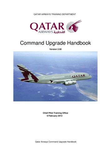
Great Western Highway Upgrade, Mount Victoria to Lithgow AllianceForty Bends Upgrade REFTechnical Paper 5: Noise and Vibration1.Introduction1.1.Proposal descriptionRoads and Maritime Services (RMS) proposes to upgrade and widen about 2.8 kilometres ofthe Great Western Highway at Forty Bends to three lanes with a central median along themajority of its length. The proposed upgrade extends from a point about 470 metres east of theeastern end of Forty Bends Road to a point about 250 metres west of McKanes Falls Road (theproposal). An overview of the proposal is shown in Figure 1-1.The proposal forms part of a series of ongoing upgrades of the Great Western Highway. TheGreat Western Highway is the main road link between Sydney and Lithgow and beyond to theCentral West of New South Wales. The Great Western Highway serves as: A key freight route between Sydney and the central west of NSW, including the timberindustry in the Oberon area.A tourist route with destinations including the Blue Mountains, historic Hartley, JenolanCaves, Mudgee and Bathurst.A connection between the many towns and villages along its length.The proposal is needed to improve the road safety and traffic capacity along this section of roadand would be consistent with other road improvement activities along the Great WesternHighway. The existing alignment has a limited number of opportunities for passing.The key features of the proposal are: The proposal has been developed based on the concept design that has been preparedusing the available information and current design standards and criteria for the GreatWestern Highway upgrade program. Some elements of the design may be further refinedduring detailed design. The key elements of the Construction of a new road alignmentconsisting of generally three lanes with two lanes eastbound to the east of Whites Creekand two lanes westbound to the west of Whites Creek. Lane widths would be 3.5 metreswith shoulder widths typically varying between 1.0 metres and 2.5 metres. The upgradealignment would diverge up to 40 metres south of the existing Great Western Highway in thevicinity of Whites Creek.The design speed for the alignment would be 100 kilometres per hour east of McKanes FallsRoad and 80 kilometres per hour west of McKanes Falls Road. The posted speed limit forthe whole of the new highway alignment would be 80 kilometres per hour.Widening of the existing alignment predominantly to the south of the Great WesternHighway. The total proposal footprint of the widening works would vary from about40 metres to 90 metres.A central median along the length of the proposal of varying widths, ranging up to 9.5metres. Carriageways would be separated by a combination of vegetated, depressed andpaved medians.NV-0684-C.docPAGE 1
Great Western Highway Upgrade, Mount Victoria to Lithgow AllianceForty Bends Upgrade REFTechnical Paper 5: Noise and Vibration Construction of new twin, five-span bridges, about 150 metres in length acrossWhites Creek. The new bridges would comprise four lanes, each 3.5 metres in width, withtwo lanes carrying traffic in each direction. The total width of the two bridges would be about30 metres. Shoulders on the bridges would be between 2.5 and 3.25 metres (off-side) and1.0 metres on the near side.Rehabilitation works along the existing alignment of Whites Creek following the removal ofthe redundant section of the existing Highway. This would include creating a rehabilitated,natural creek bed in this location linking the existing alignment of Whites Creek prior topassing under the new Whites Creek bridge.Upgrades to four existing local road intersections, including two intersections withForty Bends Road, Daintree Close and McKanes Falls Road, to provide connection to theupgraded highway and property access points. Upgrades would include minor widening andu-turn facilities located along the western end of Forty Bends Road and about 150 metressouth of the intersection of the Great Western Highway and McKanes Falls Road.New or improved access from the existing highway to nine properties along the length of theproposal. The proposal includes provision of new or reconstructed driveways to retainexisting property access.Closure and relocation of two intersections of Forty Bends Road with the Great WesternHighway. These include: Closure of the existing intersection at the eastern end of Forty Bends Road to generaltraffic (except for emergency vehicles) and a new cul-de-sac constructed on Forty BendsRoad. Relocation of the existing intersection at the western end of Forty Bends Road to a pointabout 200 metres west of the existing intersection.Five major cuts 14 metres to 19 metres in height located on the northern side of theproposed alignment.Five major fill embankments 10 metres to 15 metres in height located predominantly on thesouthern side of the proposed alignment.Three retaining walls would be required at the following locations Retaining wall 1 – between approximate chainages 32080 and 32190 (about 110 metreslong and up to 7.0 metres high). Retaining wall 2 – between approximate chainage 32560 and 32725 (about 165 metreslong and up to 5.6 metres high). Retaining wall 3 – between approximate chainage 33040 and 33240 (about 200 metreslong and up to 7.0 metres high).Removal of about 300 metres of redundant Great Western Highway pavement from about100 metres east of Whites Creek to about 200 metres west of Whites Creek, and associatedculvert. This would include rehabilitation works to link this area to the existing alignment ofWhites Creek.NV-0684-C.docPage 2
Great Western Highway Upgrade, Mount Victoria to Lithgow AllianceForty Bends Upgrade REFTechnical Paper 5: Noise and Vibration Construction of three temporary and five permanent construction basins in addition totemporary access tracks along the length of the proposal.Construction of nine new culverts along the length of the proposal to manage crossdrainage flows and six new culverts across access roads and service roads as part of theproposal. One existing culvert would be retained at the western end of the proposal. A totalof 23 existing drainage culverts under the Great western Highway would be eitherdecommissioned or removed.Measures to mitigate the formation of black ice, including the relocation of the roadalignment to the south away from the Hassans Walls escarpment in key locations and anactive maintenance program.A main compound site located east of the western end of Forty Bends Road, in addition tosmaller stockpile areas along the length of the proposal during construction.A combination of wildlife crossing structures, which would include three fauna underpasses(box culverts), canopy rope bridges at Whites Creek and the western underpass and gliderpoles located at Whites Creek and near the western fauna underpass.Relocation of the existing intersection at the western end of Forty Bends Road to a pointabout 200 metres west of the existing intersection.1.2.Purpose of this studyThis noise and vibration assessment is part of the Review of Environmental Factors (REF) forthe Forty Bends upgrade of the Great Western Highway and presents the findings of theconstruction and operational noise and vibration assessment undertaken as part of the conceptdesign development for the project. The following elements have been reviewed for this study: Operational traffic noise and vibration impacts. Operational mitigation requirements. Preliminary construction noise and vibration impacts. Consideration of project specific mitigation for construction noise.1.3.Study areaThe noise and vibration study extends to an area 600 metres from the centreline of theproposed upgrade and is shown in Figure 1-1.NV-0684-C.docPage 3
3150031600318003190032000321003220032300WHI317 TESCREE00KHASSANS WALLS04031TREE CLOSEDA I N09032000330103302031BEND01031SROA00031D09030330 07065 02.23208030NKAREEKMCKSLIMIT OF WOR03031FORTY BENDSF ORT Y333003340000332To LithgowAW A LLS ROITDOASRLLFAESCESWHLITMIOFWORKSTo SydneyGDA 94 MGA 56Fig 1-1: Overview: Forty Bends upgradeLEGEND31300Mt Victoria to Lithgow: Great Western Highway upgradeChainagePermanent drainage basinsProposalTemporary drainage basinsProposal siteMV2L Alliance does not warrant that thisdocument is definitive nor free of error and doesnot accept liability for any loss caused or arisingfrom reliance upon information provided herein.Existing highwayAerial Photograph:AUSIMAGE/SKM 2011Waterways600m assessment buffer LOCALITYCompound site and stockpile locationsPotential compoundPotential stockpilePotential stockpile and 200MetresAerial Photograph:AUSIMAGE/SKM 2011I:\NBIF\Projects\NB11343\Technical\GIS\Spatial Directory\ArcGIS\Section 5\MV2L 020 Section5 NOISE Overview A1.mxd aarcot 29/08/2012ASS3240032500003260703208032T WESTERNGREAHIGHWAYSDHAN
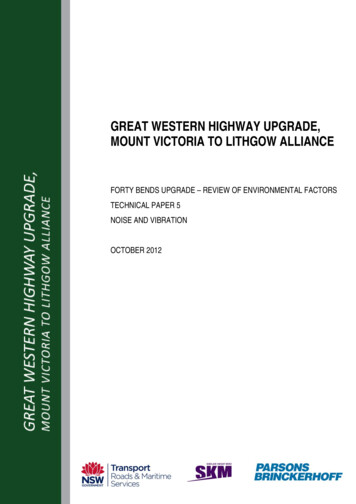
Great Western Highway Upgrade, Mount Victoria to Lithgow AllianceForty Bends Upgrade REFTechnical Paper 5: Noise and Vibration2.Existing noise environmentQuantifying the influence of the existing environment assists in the application of the projectcriteria and allows a noise model for the proposal to be calibrated. It also provides backgroundnoise levels used to assess construction noise impacts for the proposal.The study area is characterised by Crown lands (nature conservation and recreation) and ruralland uses with a small local community of farms and rural residences located between McKanesFalls Road and Forty Bends Road. This noise and vibration assessment for the REF hasincluded the identification of dwellings for the acoustic investigation area (600 metres from theproposed road centreline) for potential noise impacts.2.1.Receiver locationsThe receiver locations have been recognised from aerial photography (January 2011).The structures in the study area have been categorised as either residential (a dwelling) or nonresidential (shed or other structure) buildings or heritage items. For more detail on the heritagestructures for this project refer to Technical Paper 4 – Non-Aboriginal Heritage. There are noother commercial or non residential noise sensitive receivers identified for the proposal. A totalof 25 residences have been identified in the study area and their locations are shown on aerialphotography with the identified heritage items, which are presented in Figure 2-1.It is recognised that new dwellings may be constructed since the aerial photography wascaptured and the sensitive receivers were identified for this assessment. Any receivers notincluded in this assessment would be considered during the detailed design.NV-0684-C.docPAGE 5
Cottage1960068Cottage 1960068000333150031600WHI317 TESCREE00K31800Culvert 5Daintree04031Culvert 4Culvert3FORTY BENDSMonte VistaCulvert 2ETY BMasonry Culvertand Retaining WallEmohF ORFormerEagle &Child 31Cottage1960116RO00031ADCulvert 109030330 07065 02.23208030NKAREEKGonna-doAW A LLS ROHASSANS WALLSMCKSLIMIT OF WORDaintreeOSDAINTRE E CL E09032Cottage1960120010333330033400Umera00332To 3208032T WESTERNGREAHIGHWAYSITDOASRLLFAESCESWHForty BendsCemetery/MonteVista gravesLITMIOFWORKSTo SydneyGDA 94 MGA 56Figure 2-1 Heritage itemsLEGEND31300Mt Victoria to Lithgow: Great Western Highway upgradeChainagePermanent drainage basinsProposalTemporary drainage basinsProposal siteMV2L Alliance does not warrant that thisdocument is definitive nor free of error and doesnot accept liability for any loss caused or arisingfrom reliance upon information provided herein.Existing highwayAerial Photograph:AUSIMAGE/SKM 2011Waterways600m assessment buffer LOCALITYCompound site and stockpile locationsPotential compoundPotential stockpilePotential stockpile and compoundPSensitive recieversHeritage 0200MetresAerial Photograph:AUSIMAGE/SKM 2011I:\NBIF\Projects\NB11343\Technical\GIS\Spatial Directory\ArcGIS\Section 5\MV2L 020 Section5 NOISE Overview withHer A1.mxd aarcot 29/08/2012ASSNDHACemetery
Great Western Highway Upgrade, Mount Victoria to Lithgow AllianceForty Bends Upgrade REFTechnical Paper 5: Noise and Vibration2.2.Noise monitoringThere were two noise sensitive receiver locations identified for the noise monitoring survey.These locations have been used for both calibration of the noise model and establishing thebackground noise levels for construction noise management. The locations accessed for themonitoring survey are listed in Table 2-1 and presented graphically in Appendix A along with thelocation of all identified receivers for the study area.Table 2-1 Monitoring locations – unattended noise surveyDescriptionIDMonitoring locationDistance from existing highway centrelineLocation 1L21McKanes Falls Road39 metresLocation 2L3Forty Bends Road210 metresUnattended noise monitoring was undertaken between 8 and 26 February 2012 using ARLnoise type 316 noise loggers. This time of year is considered to be a reasonable approximationof standard traffic flows in the area and does not fall in public holiday or school holiday periods.Meteorological data was obtained from Bureau of Meteorology (BoM) for the Mount BoyceWeather Station for the month of February 2012. The meteorological data was thenincorporated into the analysis of the measured noise levels and any data considered to beinvalid due to adverse weather was removed from the results. Adverse wind conditions includewind speeds that exceed five metres per second and periods of rain. Where noise data may bepotentially affected, it has not been included in the calculation of statistical parameters.The measured noise levels are statistically analysed to provide more detail of the character ofthe noise environment over the long term. Statistical descriptors are used in the assessment ofimpacts for both traffic noise and environmental noise for the proposal and are categorised byday, evening or night time periods. For road traffic noise these are classified for daytime (7:00am to10:00 pm) and night time (10:00 pm to 7:00 am) periods. For environmental noise, theassessment period for night time is the same, while day time is further split into day (7:00 am to6:00 pm) and evening (6:00 pm to 10:00 pm) periods.Both the environmental and traffic noise information is extracted from the same monitoring dataat each location. The monitoring data are differentiated for use as environmental backgroundnoise levels or traffic noise levels using acoustic parameters specific to each type ofassessment.The monitoring for the construction assessment measures the ambient noise levels to provideinformation on the current noise environment, which may also include any existing traffic noiseinfluences. The data used to derive construction noise goals are based on LA90 statistics for theday, evening and night time periods and this is often called the background noise level. Detailsof the construction noise assessment using these parameters are given in Section 5.NV-0684-C.docPAGE 7
Great Western Highway Upgrade, Mount Victoria to Lithgow AllianceForty Bends Upgrade REFTechnical Paper 5: Noise and VibrationThe daily environmental noise measurement profile for each location is shown graphically inAppendix B and the results have been summarised in Table 2-2. The rating background level(RBL) in the table is the median of the background noise levels for the site and is used whendetermining the construction noise management level while the Lmax and LAeq levels provideinformation on the existing environment.Table 2-2 Summary of monitoring results - environmental noise 5735673542941At Location 3, vehicles on the highway are approximately 200 metres to the west at the closestpoint resulting in quieter noise levels than at Location 21. Due to the alignment of the existingroad, which curves around the receivers in this location, the duration of a single vehicle passbywas subjectively longer than at Location 21. The night time RBL at Location 3 is higher than thatnear the road, and this is expected to be due to the night time noise influence of the localwildlife and not as a result of road traffic.At Location 21, observations of the noise environment included frequent truck movements withsome wildlife such as crickets and birds audible during breaks in traffic. Dominant traffic noisewas mostly from truck engine with some tyre/road noise and only occasional engine brakenoise.2.3.Traffic noise descriptorsIn analysing the same noise monitoring data using different parameters, an indication of thetraffic noise levels adjacent to the existing alignment is also determined for each of the sites.The LAeq 15 hour and 9 hour data is used to correlate traffic noise levels against the noisemodelling predictions in Section 4. The results of the traffic noise monitoring for the proposal areprovided in Table 2-3.Table 2-3 Summary of monitoring results - traffic noise descriptorsLocationIDLA10 18 hourL3L21NV-0684-C.docLAeqLAeq15 hour9 54.073.472.6Page 8
Great Western Highway Upgrade, Mount Victoria to Lithgow AllianceForty Bends Upgrade REFTechnical Paper 5: Noise and VibrationThe maximum noise levels reported for Location 21 for the daytime and the night time periodsare shown to be similar and are expected to be caused by noise emissions from heavy vehiclesengines and exhausts. At Location 3 the maximum day time levels are likely to be the result ofwildlife, mostly birds, which inhabit a small wooded area along Forty Bends Road adjacent tothe monitoring location.NV-0684-C.docPage 9
Great Western Highway Upgrade, Mount Victoria to Lithgow AllianceForty Bends Upgrade REFTechnical Paper 5: Noise and VibrationNV-0684-C.docPage 10
Great Western Highway Upgrade, Mount Victoria to Lithgow AllianceForty Bends Upgrade REFTechnical Paper 5: Noise and Vibration3.Regulatory requirements3.1.Operational noise criteriaThe assessment of noise impacts for road projects is guided by the Office of Environment andHeritage (OEH) New South Wales Road Noise Policy (RNP) (DECCW, 2011). The RMSprovides additional information in the Environmental Noise Management Manual (ENMM) (RTA,2001) to assist in the application of the criteria and the development of noise mitigationmeasures where required.The base criteria for operational noise are absolute values that consider noise emissions fromtraffic on new or upgraded sections of road. These criteria are outlined in the RNP and arebased on studies of national and international practice for road noise assessments. The RNPrecognises that the existing environment may already have a high traffic noise influence or maybe in an area where traffic noise is minimal. In these cases the base criteria are augmented withadditional criteria to account for the existing level of impact.The criteria for the assessment of road traffic noise outlined in the RNP are supplemented with“interim approaches” developed by RMS to implement the new policy provisions. These interimapproaches outline how the provisions in the ENMM apply to the requirements of the RNP.These documents work together to assist in developing feasible and reasonable noisemitigation options where project noise levels exceed the RNP assessment criteria.A set of standard evaluation scenarios for road projects is outlined in the RNP. These arenecessary to provide a fixed assessment for all road projects on which to base consideration ofimpacts. The evaluation of noise impacts is undertaken for two timeframes: within one year of changed traffic conditions. for a design year (typically ten years) after changed traffic conditions.For each of these timeframes, a comparison is made between: the road traffic noise levels if the project proceeds, known as the ‘build option’, andthe corresponding road traffic noise levels, due to general traffic growth, that would haveoccurred if the project had not proceeded, known as the ‘no build option’.Under the RNP, road development is either classified as ‘new road’ or ‘redevelopment of anexisting road’. Each road classification has a base criterion for both day and night timeassessment periods. The consideration of a lower set of criteria for night time in both cases is inrecognition of the quality of the noise environment necessary for restful sleep. The projectspecific criteria are listed in Table 3-1.NV-0684-C.docPAGE 11
Great Western Highway Upgrade, Mount Victoria to Lithgow AllianceForty Bends Upgrade REFTechnical Paper 5: Noise and VibrationTable 3-1: Road traffic noise base criteriaRoad categoryType of project/land useDaytime noisecriteriaNight-time noisecriteriaFreeway/arterial/sub-arterial roads1. Existing residences affected by noise from newfreeway/arterial/sub-arterial road corridorsLAeq (15hour) 55 dB (A)LAeq (9hour)50 dB (A)2. Existing residences affected by noise fromredevelopment of existing freeway/arterial/subarterial roadsLAeq (15hour) 60 dB (A)LAeq (9hour)55 dB (A)The factors that affect how noise sensitive receivers are categorised include the influence ofexisting traffic noise, the direction that new noise emissions will impact a receiver, and thelocation of the new alignment within the existing road corridor. All receivers identified for thisstudy have been categorised as redeveloped road receivers.The initial designation of development type (ie ‘new’ or ‘redeveloped’) for the receivers identifiedin this report is based on a visual assessment of existing traffic noise influences, and thelocation of the proposed upgrade in relation to the identified receivers.In areas of new or existing impact, the RNP recommends that a relative increase in total trafficnoise levels of more than 12 dB(A) should be considered for mitigation. This relative increasecriterion does not apply for open spaces or where the road to be assessed is a local road.Table 3-2 presents a sum
3.2. Maximum noise level assessment - sleep disturbance 13 3.3. Construction noise criteria 13 3.4. Construction vibration criteria 15 4. Operational noise assessment 19 4.1. Assessment parameters 19 4.2. Noise modelling results 23 4.3. Maximum noise level assessment 25 4.4. Operational mitigation 26 5. Construction noise and vibration 29 5.1.