Transcription
Flood Insurance Rate Map (FIRM)Panel Technical ReferenceFormat for Flood Insurance Rate MapsDecember 2020
FIRM Panel Technical ReferenceFor more information, please visit the FEMA Guidelines and Standards for Flood RiskAnalysis and Mapping webpage es-standards). Copies of the Standards for Flood Risk Analysis andMapping policy, related guidance, technical references, and other information about theguidelines and standards development process are all available here. You can alsosearch directly by document title at uctionsThis version of the Technical Reference must be used on projects as described below.Generally, the changes in this version may also be implemented on any project, in coordinationwith the FEMA Project and Contracting Officer’s Representative.Revision DateImplementationDecember 2020Implemented for all projects beginning Data Development after December30, 2020.Table of RevisionsThe following summary of changes details revisions to the FIRM Panel Technical Referencesubsequent to its most recent version in February 2019.Affected Sectionor SubsectionSection 1,Section 5 andSection 7Revision DateDecember 2020Guidelines and Standards forFlood Risk Analysis and MappingRevision DescriptionAdded section about Automated Map Production.Updated information regarding Levee Systems.Page iFIRM Panel Technical Reference
FIRM Panel Technical ReferenceTable of Contents1.0Automated Map Production (AMP) . 12.0Introduction . 13.0Map Production Formats . 13.1Countywide Format . 13.2Multiple-County Communities . 23.3Partial Countywide Map Format . 43.4Single-Jurisdiction (Community-based) Format. 64.0Map Frames . 64.1Frame Sizes. 64.2Frame Size Exceptions . 65.0Map Body .115.1Base Map .115.1.15.2Depiction of Base Map Features .12Depiction of Flood Hazard Features .195.2.1Floodplains and Floodways.195.2.2Flood Hazard Information Based on Future-Conditions Analyses .195.2.3Zone Labels .195.2.4Base Flood Elevations .195.2.5Cross Sections.205.2.6Cross Section Labeling .205.2.7Limit of Study .205.2.8Coastal Transects .205.2.9Coastal Transect Labeling .215.2.10Limit of Moderate Wave Action .215.3Other Flood Hazard Features and Notes .296.0Map Legend .307.0Notes to Users.378.0Scale Box and Panel Locator Diagram .469.0FIRM Title Block .5010.0Preliminary Flood Insurance Rate Map Deliverables .5611.0Map Service Center Deliverables .5812.0National Flood Hazard Layer .58Guidelines and Standards forFlood Risk Analysis and MappingPage iiFIRM Panel Technical Reference
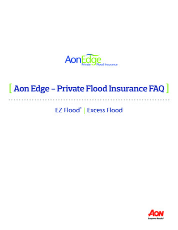
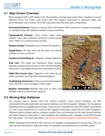
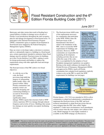
FIRM Panel Technical ReferenceList of FiguresFigure 1. Map Frame Dimensions .7Figure 2. Map Frame Dimensions Including Logo Sizes and Locations .8Figure 3. Map Frame Margin Standards .9Figure 4. Folding Standards .10Figure 5. Text Size and Corresponding Halo Sizes .11Figure 6. Legend Standards .30Figure 7. FIRM Orthophoto Base Map Legend .32Figure 8. FIRM Vector Base Map Legend .33Figure 9. FIRM Notes to Users Standards.37Figure 10. FIRM Notes to Users .37Figure 11. FIRM Levee Notes to Users .38Figure 12. FIRM Levee Seclusion Legend Addition .39Figure 13. FIRM Levee Seclusion Legend Addition, Customized . 39Figure 14. Limit of Moderate Wave Action Notes to Users .40Figure 15. FIRM Flowage Easement Area Notes to Users .40Figure 16. Scale Box and Map Locator Diagram Standards .46Figure 17. Panel Locator Diagram.47Figure 18. FIRM Title Block Standards .51Figure 19. FIRM Title Block .52Figure 20. Title Block with Preliminary Stamp .57Guidelines and Standards forFlood Risk Analysis and MappingPage iiiFIRM Panel Technical Reference
FIRM Panel Technical ReferenceList of TablesTable 1. Base Map Features: Leader Line .11Table 2. Base Map Features: Transportation .13Table 3. Base Map Features: Hydrographic .14Table 4. Base Map Features: Hydraulic Structures .15Table 5. Base Map Features: Boundaries and Political Areas .16Table 6. Base Map Features: Horizontal Reference Grids and Panel Tile Notes . 17Table 7. Standard Flood Hazard Features and Notes .22Table 8. Other Flood Hazard Features .29Table 9. Map Legend Neat Lines .31Table 10. Map Legend Features .35Table 11. Notes to Users .41Table 12. Panel Locator Diagram .48Table 13. Scale Box .49Table 14. FIRM Title Block .53Table 15. Preliminary FIRM Title Block .56Guidelines and Standards forFlood Risk Analysis and MappingPage ivFIRM Panel Technical Reference
FIRM Panel Technical Reference1.0Automated Map Production (AMP)To support greater automation within the Risk MAP Program, FEMA is developing a tool withinthe Mapping Information Platform (MIP) called Automated Map Production (AMP). AMP willautomate FIRM panel creation, replacing previous practices of manual cartography. The goal ofAMP is to eliminate the need for manual edits or adjustments to labels on the FIRM panels andFIRM index.AMP will read the data in a submitted FIRM database and use a series of cartographicalgorithms, with established rules of hierarchy, to autogenerate FIRM panels and indexes thatcomply with FEMA requirements through all study stages (e.g. draft, preliminary, and final).However, AMP will not change the engineering analysis or alter the FIRM database (i.e.geodatabase; shapefiles). AMP will not fix errors in the submitted FIRM database (e.g.topology). It will continue to be the responsibility of the FIRM database producer to performquality assurance / quality control (QA/QC) to make sure the submitted data meets all Risk MAPstandards. Producers will also be expected to visually review the auto generated AMP panels todetermine if they meet expectations or require changes. If updates are needed, the producer willedit the FIRM database and then resubmit to the MIP as usual to begin the process over, toinclude required DVT submittals.As AMP is introduced into the Risk MAP study lifecycle, producers need to understand how itwill impact the information in this document. While the mission of AMP is to replicate the FIRMpanel and FIRM index requirements as known today, there will be changes to the output panelsthat do not directly align with the guidance and direction in this and other Risk MAP documents.AMP panels will have slight variations from what producers and users have seen since thebeginning of Risk MAP. FEMA will develop a best practice document to summarize thesechanges. Because AMP will be enhanced through future agile development cycles, changes willlikely occur more frequently than the annual Guidelines and Standards (G&S) cycle. Therefore,the best practice model will be the most efficient way to provide up-to-date information onchanges. Future edits to this document will be made to align the information between this andthe AMP best practice document.2.0IntroductionThis document provides the specifications for the content and graphic presentation of all of theelements of a Flood Insurance Rate Map (FIRM). Additional guidance on graphic presentationof individual FIRM elements may be found in the FIRM Graphics Guidance document. Guidanceon base map elements may also be found in the Base Map and FIRM Panel Layout Guidancedocument.3.0Map Production Formats3.1Countywide FormatFIRMs will most often be prepared in the Federal Emergency Management Agency (FEMA)countywide format, whereby all jurisdictions within a given county are shown on one set of FIRMPanels.Guidelines and Standards forFlood Risk Analysis and MappingPage 1FIRM Panel Technical Reference
FIRM Panel Technical ReferenceFor FIRM Panels and FIRM Databases, cross-section information shall be lettered or numberedsequentially along each flood source and contain Water Surface Elevations (WSELs) that areconsistent for the length of the flooding source.Where analyses overlap community boundaries and analyses do not agree, the analysis withthe most recent effective date shall be used.3.2Multiple-County CommunitiesWhen processing a countywide FIRM that contains a multiple-county community, the assignedMapping Partner shall select from one of the three processing options described below.Before a decision is made regarding the processing method, which occurs during theDiscovery/Project Planning Phase (see the Discovery Guidance document), the followingquestions must be answered: In how many counties does the subject community lie? How are the multiple-county communities shown on the FIRMs of surrounding counties? What is the status of the surrounding counties relative to countywide processing? Does the subject community have full jurisdiction over its lands? How much of the subject community falls within the county that is being processed? What is the map scale of the existing community-based FIRM or countywide FIRM? How many panels would be added to the countywide FIRM in order to include thesubject community in its entirety?Once these questions have been answered and all information has been obtained, the finaldecision regarding processing shall be made in consultation with the FEMA Project Officer. Thethree options discussed below ensure seamless mapping coverage for all jurisdictions andprevent overlapping and/or duplicated flood hazard information from being shown on twoseparate FIRMs. The most up-to-date analysis should be applied from one community toanother if there are data disagreements.Processing Option 1: Single JurisdictionUnder this option, the FIRMs of the surrounding counties would show the community as an“Area Not Included” (ANI), with no flood hazard or base map information shown, and thecommunity would retain the format of its Single-Jurisdiction FIRM. If orthophoto base maps areused for the countywide FIRMs, the base map imagery will continue through the ANI. When thisoption is chosen during the processing of a countywide format FIRM, a concurrent communitybased FIRM revision must be processed, if required, to ensure that seamless coverage betweenthe multiple-county community and the surrounding counties will be maintained. Minor revisionsof the FIRMs of adjacent counties may be necessary to ensure that no overlaps or gaps incoverage exist.Guidelines and Standards forFlood Risk Analysis and MappingPage 2FIRM Panel Technical Reference
FIRM Panel Technical ReferenceOnly National Flood Insurance Program (NFIP) communities (i.e., those that have beenassigned a Community Identification Number [CID]) may be shown as an Area Not Included. Allother land-use areas, such as military reservations, shall be shown and labeled on the FIRM.Processing Option 2: Entire Community Mapped in Only One of theCountywide FIRMsUnder this option, the entire community is mapped on the new countywide FIRM. This optionshall be used when the following criteria are met: The multiple-county community can be shown on the new countywide FIRM withoutsubstantially increasing the panel count; and At least 70 percent of the community area is located within the countywide FIRM beingprocessed.When Processing Option 2 is chosen, the assigned Mapping Partner shall notify the FEMAFlood Map Service Center (MSC) to supersede the community-based FIRM for the multiplecounty community. The MSC must also be advised to include a notation in the Flood MapStatus Information System that the multiple-county community is shown in its entirety on thenew countywide FIRM. The adjacent counties will continue to show the multiple-countycommunity as an Area Not Included (ANI) on their FIRMs, even if their FIRMs are converted tothe countywide format at a future date. This decision will be made on a case-by-case basis withthe FEMA Project Officer.Processing Option 3: Community Split Between CountiesUnder this option, flood hazards in the multiple-county community are shown on the countywideFIRMs of the respective counties. This option shall be used only when the following criteria aremet: All adjacent counties in which the multiple-county community is located either alreadyhave countywide FIRMs or will in the near future; and The multiple-county community has been consulted and has not expressed significantconcerns with being shown on more than one countywide FIRM.When Processing Option 3 is chosen, if the processing of any of the contiguous countywideFIRMs that share the subject community are delayed (usually as a result of an appeal, protest,or other flood risk project complication), thereby making it impossible for all countywide FIRMsto become effective at the same time, the multiple-county community shall retain the effectivecommunity-based FIRM or previous single- or multiple-county map for the portion of thecommunity in the county with the delayed map. In this situation, the assigned Mapping Partnermust consult the FEMA Project Officer for a decision on how to proceed. Decisions will be madeon a case-by-case basis but must result in continuous and non-conflicting coverage for all landareas being mapped. Once all issues causing the delay are resolved, the assigned MappingPartner can proceed with the inclusion of the community into each countywide FIRM.Guidelines and Standards forFlood Risk Analysis and MappingPage 3FIRM Panel Technical Reference
FIRM Panel Technical ReferenceWhen Processing Option 3 is chosen, the assigned Mapping Partner must notify the MSC tosupersede the community-based FIRM for the multiple-county community.3.3Partial Countywide Map FormatCurrent methods for publishing partial countywide maps are very inefficient, mainly becausenew panel layout schemes differ from prior panel layouts, resulting in the partial overlap ofunrevised panels surrounding the updated area with the panels for the revised area. Becausethe overlapping panels must be modified to avoid duplicate coverage and subsequentlyrepublished, the cost of updated information is higher, per panel, than the full countywidemapping. As a result, the burden and cost of producing partial countywide maps may outweighthe benefits.Digital conversion of only the revised panels (partial digital conversion) is not the preferredoption, but it may be undertaken when funding constraints prohibit a full digital conversion.Before requesting partial countywide mapping format approval from the FEMA Region office,the Mapping Partner performs a cost comparison to the standard countywide format, writtenjustification of the decision to pursue partial countywide mapping, and determines answers tothe following questions: How many panels will the partial countywide mapping entail? How many existing panels will be unaffected? How many existing panels will need to be republished as “This Area Shown” panels?(These are panels that refer the user to another panel for information). How many communities are in the county? How many communities will be completely mapped by the partial countywide mapping? How many communities will be only partially mapped as a result of the partialcountywide mapping limits? How many of these communities have an effective Flood Insurance Study (FIS) Reportthat will need to be revised and republished? Will adding additional panels to the partial countywide mapping plan complete any ofthese communities and eliminate their single-community FIS Report? How many existing detailed flooding sources are there in all communities? What are the existing map formats? How many Letters of Map Revision (LOMRs) will be incorporated into the partialcountywide mapping? How many LOMRs will not be incorporated?Guidelines and Standards forFlood Risk Analysis and MappingPage 4FIRM Panel Technical Reference
FIRM Panel Technical Reference How many detailed flooding sources will be fully mapped in the partial countywidemapping? How many detailed flooding sources will be only partially mapped as a result of thepartial countywide mapping limits? How will the cross-section lettering appear on the partial countywide panels and theexisting unrevised panels where a traditional continuous lettering series is not possiblenow? Will there be a datum issue created by the partial countywide mapping limits? Will adding additional panels to the partial countywide mapping simplify any of the crosssection re-lettering and datum conversion challenges?Because each proposed partial countywide mapping project is unique, FEMA will evaluatesubmittals on a case-by-case basis.The FEMA Region, in consultation with FEMA Headquarters, will evaluate the request andapprove or disapprove the request based on information provided by the Mapping Partner. TheFEMA Region will advise the Mapping Partner of the decision in writing and will copyHeadquarters and FEMA’s national contractor(s).Datum ConversionSince most existing FIRMs are referenced to the National Geodetic Vertical Datum of 1929(NGVD29) and new FIRMs are referenced the North American Vertical Datum of 1988(NAVD88), partial countywide mapping will, at a minimum, create dual-datum FIRMs for thecounties. Flood Profiles and Floodway Data Tables (FDTs) within an individual FIS Report willnow be potentially referenced to either datum, which will increase the complexity of productionand quality control reviews. To minimize datum shifts within individual Flood Profiles and FDTs,minimize the number of partially mapped, detailed flooding sources by carefully selecting theFIRM panels to include in the partial countywide layout.Lettered Cross SectionsIn the traditional countywide process, the entire length of a detailed stream is re-lettered into acontinuous sequence. In a partial countywide, some portions of a detailed stream may fall onpanels not planned for publication, making a continuous lettering series impossible. To minimizelettering discontinuities, minimize the number of partially mapped detailed flooding sources as aresult of the partial countywide limit; consider expanding the number of panels included in thenew partial countywide layout to accomplish this. New cross sections inserted between existingcross sections should be numbered with an alphanumeric sequence (i.e., cross sections 5A and5B may be inserted between existing cross sections 5 and 6).Guidelines and Standards forFlood Risk Analysis and MappingPage 5FIRM Panel Technical Reference
FIRM Panel Technical Reference3.4Single-Jurisdiction (Community-based) FormatA single-jurisdiction FIRM is an option when funding constraints or lack of suitable base mapdata prohibit full countywide mapping.4.0Map FramesThe frame size for the FIRM panels is defined in the following sections.4.1Frame SizesAll FIRM panels shall be printed to the dimensions shown below: Trimmed paper size: Height 36” x Width 24”, Architectural D (ARCH D) Map border size: Height 35.5” x Width 23.5” Map Panel border: Height 25.5” x Width 23” Legend, msc.fema.gov note border: Height 9” x Width 5.3” Notes to Users, Logos border: Height 9” x Width 5.6” Panel Locator, North Arrow, Scale Bar border: Height 9” x Width 5.6” Map Info Panel, FEMA NFIP Logo border: Height 9” x Width 5.3” Figures 1 through 4 describe the dimensions of a FIRM map frame, including the overalldimensions (1), the dimensions including logo sizes and locations (2), frame marginstandards (3), and frame folding standards (4). See section 5, Map Legend, for detailedinformation regarding the legend.The map image size (the image inside the FIRM neatline) shall vary depending on the latitude ofthe community being mapped.The map panel border shall be a plain black line with a line weight of 1.0pt.4.2Frame Size ExceptionsWhen the dimensions specified in section 3.1 cannot be matched because the map image sizesare larger due to far southern latitudes, a different system of measurement has been used, orother reasons that would make the use of ARCH D – sized paper not feasible, a different mapsize may be used at the discretion of the FEMA Project Officer. Examples may include Hawaii(Universal Transverse Mercator [UTM] projection size), North Carolina, and Puerto Rico(metric). If an alternative size is selected, all other map content not related to map format in thisdocument must be adhered to.Guidelines and Standards forFlood Risk Analysis and MappingPage 6FIRM Panel Technical Reference
FIRM Panel Technical ReferenceFigure 1. Map Frame DimensionsGuidelines and Standards forFlood Risk Analysis and MappingPage 7FIRM Panel Technical Reference
FIRM Panel Technical ReferenceFigure 2. Map Frame Dimensions Including Logo Sizes and LocationsGuidelines and Standards forFlood Risk Analysis and MappingPage 8FIRM Panel Technical Reference
FIRM Panel Technical ReferenceFigure 3. Map Frame Margin StandardsGuidelines and Standards forFlood Risk Analysis and MappingPage 9FIRM Panel Technical Reference
FIRM Panel Technical ReferenceFigure 4. Folding StandardsGuidelines and Standards forFlood Risk Analysis and MappingPage 10FIRM Panel Technical Reference
FIRM Panel Technical Reference5.0Map BodyThe body of the FIRM shall comprise base map information and flood hazard information,including any special notes needed for clarification.*NOTE: Throughout this document, the following abbreviation conventions are used to specifythe case of text appearing on the FIRM: CAPS: All upper caseCLC: Upper and lower caseHalosAll labels shown on FIRM panels with a raster base map shall be depicted with a white halo toensure readability of all annotation. Labels on FIRM panels using a vector base map shall bedepicted with a white halo when overprinting occurs, or the label is not clearly visible on theFIRM panel. Halo specifications are shown below in Figure 5.Figure 5. Text Size and Corresponding Halo SizesText Size (pt)Halo Size (pt)Below 120.7512 - 141.0Greater than 141.25Leader LinesLabels may be leadered to a feature using a plain line if space does not permit the label to beadjacent.Table 1. Base Map Features: Leader LineExampleFeatureStandard *[Hatch Pattern] (RGB Values)Leader lineLine weight 1.0 Pt, Black* Font standards that cannot be matched may be approximated5.1Base MapBase maps form the backdrop against which flood hazard information is viewed. Base mapscover the entire geographical area of a community and include planimetric data such astransportation features, hydrographic features, hydraulic structures, landforms, and politicalboundaries. Base map features are employed by map users to identify properties and structuresrelative to the floodplains.Guidelines and Standards forFlood Risk Analysis and MappingPage 11FIRM Panel Technical Reference
FIRM Panel Technical Reference5.1.1 Depiction of Base Map FeaturesThe assigned Mapping Partner shall depict the following types of base map features on theFIRM if they occur within the community: Transportation features, including roads and railroads, shall be depicted. If digitalorthophotos are supplied, these features must be clearly visible. Structures that areincluded in the hydraulic models shall be included on the FIRM. Hydrographic features (e.g., streams, rivers, lakes, shorelines) shall be depictedfollowing the guidance in Table 3 regarding the display of hydrographic features andTable 8 regarding profile baselines. Hydraulic structures (e.g., levees, dams, weirs, floodwalls, jetties) shall be depicted. Alllevee systems shall be mapped, and those that do not meet the certificationrequirements in Section 65.10 of the NFIP Regulations should be mapped and noted asnot recognized as reducing the flood hazard from the 1-percent-annual-chance flood.Notes accompanying levee systems shall be shown on the map as specified in Table 7. Boundaries that identify county and State boundaries, corporate limits, extraterritorialjurisdiction (ETJ) areas, military lands, and tribal lands shall be depicted. U.S. Public Land Survey System (PLSS) features, also known as range, township, andsection lines, and their designators, shall be depicted.The assigned Mapping Partner shall separately symbolize base map features that are notclearly visible on the orthophoto if their location within a floodplain is significant to the floodplainanalysis. Base map features that are referenced on the Flood Profile in the FIS Report shall besymbolized and labeled on the map.Transportation FeaturesAny road shown and labeled on a Flood Profile shall be labeled on the map. As many namedroads as possible should be labeled inside of and within 1 inch of a Special Flood Hazard Area(SFHA). Primary roads, as defined by the Master Address File (MAF) / Topologically IntegratedGeographic Encoding and Referencing (TIGER) data, farther than 1 inch from an SFHA, shal
elements of a Flood Insurance Rate Map (FIRM). Additional guidance on graphic presentation of individual FIRM elements may be found in the FIRM Graphics Guidance document. Guidance on base map elements may also be found in the Base Map and FIRM Panel Layout Guidance document. 3.0 Map Production Formats 3.1 Countywide Format