Transcription
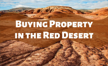
Buying Propertyin the Red Desert
Sweetwater County’s Red Desert BasinThank you for looking into development requirements in Sweetwater County’s Red Desert Basin. Thefollowing will provide general information about the area as well as outline the County’sdevelopment requirements.The Red Desert is part of the Great Divide Basin which is a high altitude, arid region along theeastern slope of the continental divide. Annual precipitation averages less than 10 inches, much ofthat coming from snowfall. June through August, the average temperature ranges from a higharound 75 to a low around 40 . Soils can be high in pH and salinity with a low bearing strength whenwet. Native vegetation consists primarily of sagebrush and sparse low grasses.Almost all property for sale in the Red Desert is zoned Agricultural which reflects the County’s vastopen spaces. Dominant land uses in this district include open range grazing and energy exploration& extraction. Most utilities and emergency services are limited or unavailable.The County considers most of the roads in the Red Desert “resource roads” which are constructedand maintained by energy companies. These roads may eventually “disappear” when production isthrough and reclamation has taken place.Most roads are not maintained and may be impassable.
How To Find Your Property On A MapNW 1/4NW 1/4 NE 1/4SW 1/4 SW 1/4SW 1/4 Se 1/4SW 1/4 SW 1/4W 1/2 E 1/2NE 1/4 NE 1/4N 1/2NE 1/4SE 1/4W 1/2E 1/2NW 1/4 NW 1/4SE 1/4SE 1/4NW 1/4 NE 1/4SW 1/4 SW 1/4SE 1/4 SE 1/4SW 1/4SW 1/4SE 1/4SE 1/4SW 1/4SE 1/4S 1/2NE 1/4SE 1/45 AcresA Township and Rangeencompasses 36 square miles;6 miles across & 6 miles down.In Sweetwater County,Townships range from T12N toT26N and run from south tonorth. Ranges run from R90W toR112W and run from east to west.10Acres5 Acres2.5AcresParcels under 35 acres areeasily recognizablebecause they contain 3 ormore location referencessuch as W1/2, NW1/4, SE1/4.Examples of parcels under35 acres are shaded in redon the map above.This property is legally described as theSouthwest Quarter of Section 29, Township 22North, Range 91 West of the 6th PrincipalMeridian, Sweetwater County, Wyoming.Your information may look like this:160 Acres, SW1/4, S29, T22N, R91W
Visit Your Property andKnow What You’re Buying!On a flat map, the property you’rethinking about buying looks verydifferent from how it looks whenyou’re actually there.The elevation change on thisparcel goes from 7,130 to6,900 a 230 Foot drop!There is also a largedrainage crossing themiddle of the propertyleaving little room fordevelopment IF you havelegal access.If you go to the Red Desert, make sure to tell someone where you are!Cellular service is very limited, roads can be impassable in certain weatherconditions and temperatures can fluctuate up to 35 in a single day!
Access to your propertyBefore making your purchase, make sure that you have a secured, legal access to your property.Wyoming State Statute 18-5-303 for Real Estate Subdivisions requires that “ingress and egress andutility easements shall be provided to each parcel by binding and recordable easements of not lessthan forty (40) feet in width to a public road unless specifically waived by the grantee ortransferee in a binding and recordable document”.If you are purchasing a property and that right has already been waived, it is YOUR responsibilityto secure access easements from all public and private property owners between you and a publicroad.The 2015 Zoning Resolution requires that all development approvals in the unincorporated areasof Sweetwater County have an approved, legal access to the lot or parcel. Private roads areallowed but must maintain a minimum right-of-way easement of 40 feet and shall not exceed 1.25miles in length unless allowed through the public hearing process. The private road must alsooriginate from a public road.By Statute , public roads are established by the County Commissioners and are usually designatedas County Roads although some Federal Roads may fall under this Statute.
Developing Your PropertyOnce you have secured those easements, the County will require that you pay for and build thepublic or private road to the requirements of Section 4.C of the Sweetwater County ZoningResolution . This section outlines the County’s parcel development standards as well as accessrequirements. A County Access and Address Permit may be required if accessing from a numberedCounty Road.Commonly, property in the Red Desert is divided into 40 acre parcels. Wyoming Statute 18-5-303exempts parcels which are 35 acres or larger from those subdivision statutes and Countyregulations as long as they meet the requirements of that exemption.If you are purchasing a property which is smaller than 35 acres, the county will require YOU toprovide documentation that your parcel was created under Wyoming State Laws. Parcels under 35acres are easily recognizable because they contain 3 or more location references such as W1/2,NW1/4, SE1/4.A construction permit is required when placing a new structure or expanding the footprint of anexisting structure. Include all items listed on the Site Plan Requirements found in the constructionpermit application.
How do I get to the nearest public road 14 MilesLooking at the map, the following are classified as public roads:Wamsutter-Crooks Gap - CR 4-23Minerals Exploration - CR 4-63Luman – CR 4-20Interstate 80Wyoming State Highway 789 and how much will itcost me to get there? 100,000 per mile is the estimated cost of a road builtto the County’s MINIMUM standards.In the example property outlined in yellow, it is over14 miles in a straight line to Minerals ExplorationRoad. That means that building a 14 mile road wouldcost YOU a minimum of 1.4 MILLION dollars!And that figure does not account for engineering,easements, drainage, fill, excavation or culverts.
WaterWater is scarce in the desert. Annual precipitation averages less than 10 inches with snowfallaccounting for much of that amount. Average annual evaporation rates are 4 – 5 times higher thanprecipitation rates. Deep drilling, possibly up to 1,000 feet, may be required to bring in a well.Well permits can be obtained by contacting the Wyoming State Engineer’s Office, Ground WaterDivision, at 307-777-6163.SepticSeptic permits are issued by the Sweetwater County Environmental Health Department. Soilconditions and percolation tests will determine if your property will support an underground systemor will require a mounded system. Contact the Environmental Health Department at 307-872-3930 withany questions.UtilitiesWind, solar, propane and generators are the primary sources of energy. Public utilities arepractically non-existent or too costly to bring to your property.
Soils & the Growing SeasonThe growing season, or frost free period, in the Red Desert is between 55 to 95 days. Average summertemperatures range from highs in the upper 70’s to lows in the 40’s. Upland soils are generally welldrained but contain high pH levels. Lowland soils are silty clay loam with elevated pH levels and highsalinity. When wet, clay soils become impermeable and have a low bearing strength.Open Range GrazingWyoming is an open range state. If you do not want someone else’s livestock roaming and grazing onyour property, you are responsible for erecting and maintaining fences. You are also responsible, andmay face criminal liability, if your pet harasses, wounds or kills livestock or wildlife – ON or OFF yourproperty.Oil & Gas Exploration and the Split EstateThe Great Divide Basin makes up one of the largest developing oil & gas fields in the continental UnitedStates. Generally, the surface is divided and separate from the minerals creating a “Split Estate”. Ifyou do not own both the surface and the mineral estates (very few people own both), your surfacerights are subservient to the mineral owners right to access your property to explore and producethose minerals. However, you may be entitled to compensation. Consider consulting an attorneyand/or contact the mineral rights holder to find out what their plans are for development.
Important WebsitesSweetwater County Land Use Codes: Subdivisions, Development, Permitting & AddressingWyoming State Statutes: State Laws, Subdivision RequirementsSweetwater County MapServer: Property Location, Aerial Photography, OwnershipSweetwater County Environmental Health: Septic PermitsWyoming State Engineer’s Office: Water WellsBureau of Land Management - Wyoming: Wyoming BLM ContactsBLM – Obtaining a Right-of-Way on Public Lands Pamphlet: Right of Way Application & Contact Info
How To Find Your Property On A Map This property is legally described as the Southwest Quarter of Section 29, Township 22 North, Range 91 West of the 6th Principal Meridian, Sweetwater County, Wyoming. Your information may look like this: 160 Acres, SW1/4, S29, T22N, R91W A Township and Range encompasses 36 square miles; 6 miles across & 6 .


