Transcription
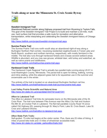
Developments Along the Overland Trail from the Missouri River to Fort Laramie,Before 1854(Article begins on page 2 below.)This article is copyrighted by History Nebraska (formerly the Nebraska State Historical Society).You may download it for your personal use.For permission to re-use materials, or for photo ordering information, se-nshs-materialsLearn more about Nebraska History (and search articles) raska-history-magazineHistory Nebraska members receive four issues of Nebraska History /membershipFull Citation: Robert W Richmond, “Developments Along the Overland Trail from the Missouri River to FortLaramie, Before 1854,” Nebraska History 33 (1952): 154-179Article Summary: Emigrants following the Oregon and California Trails found little in the way of shelter andother facilities to aid them in their journey to the PacificCataloging Information:Names: William Sublette, Myra Eells, Francis Parkman, J G Bruff, William Clayton, William Lobenstine, GilbertCole, Henry J Coke, John Wood, John C Fremont, William Kelly, Howard StansburyKeywords: American Fur Company, Mormons, Fort William (later Fort Laramie), Fort Kearny, Rock Creek, AshHollow, Robidoux Pass, Fort Bernard, Fort PlattePhotographs / Images: outline map of Nebraska showing trails and crossings
DEVELOPMENTS ALONGOVERLAND TRAIL FROM THEMISSOURI RIVER TO FORT LARAMIE,BEFORE 1854*BY ROBERT W. RICHMONDHE great highway to the West, the Overland Route, wasknown by many names. It was called the Platte Trail,the Central Route, the Emigrant Road, the MormonTrail and the California Trail by the men who traveled it,while the Indians of the vast area through which it randubbed it the "Great Medicine Road of the Whites" and the"White-Topped Wagon Road."From Independence and various points on the Missouricame the emigrants. They crossed the Wakarusa, the Kawand the Big Blue and moved into Nebraska; or they camedirectly across the "Big Muddy" from the Iowa side. Thevalley of the Platte became a thoroughfare for thousandsof homeseeking and adventure-hunting travelers.The emigrants who followed the Oregon Trail encountered fewer streams to cross than did those who traveledthe north bank of the Platte. The tributaries of the LittleBlue offered little trouble to the travelers and the watershedwas such that no difficult crossings were necessary until the* This, the first of a series of two articles, is concerned withthe Oregon and California trails. A second article will considerfacilities along the Mormon Trail.[154]
NEBRASKAKEY:010 0'()I 100Ml 12345-OLD FORT KEARNYROCK CREEK CROSSINGLOWER CALIFORNIA CROSSINGUPPER CALIFORNIA CROSSINGSI\UNE FORDCD eoNV FORT KEARNYASH HOLLOWSCOTT'S BLUFFOREGON TRAILOX BOW TRAIL
DEVELOPMENTS ALONG OVERLAND TRAIL155fords on the South Platte were reached. West of the SouthPlatte the Laramie River was the only major water barrier.Ash Hollow with its steep descent proved hazardous, but thegrazing and water it afforded counter-balanced the danger.Salt Creek was the only troublesome stream in the pathsof the pioneers who came across the eastern part of Nebraskato join the Oregon Trail.The central route to the Pacific, of which the Nebraskatrails were a part, followed the "line of least resistance."It was the shortest feasible way to the Oregon country andit avoided the deserts of the Southwest which lay betweenSanta Fe and California. Even though James FenimoreCooper, in the introduction to The Pmirie wrote of theGreat Plains as akin to the "steppes of Tartary," the "desert"of his mind and writing was not so cruel to emigration asother areas might have been.The emigrants found little in the way of shelter andother facilities to aid them in their journey to the Pacific.The purpose of these articles is to evaluate the extent andcondition of those facilities which were available on thecentral overland route from the Missouri River to the Laramie hills prior to the organization of Nebraska Territoryin 1854.IPrior to the spring of 1830, wagon traffic on the OregonTrail was unknown. William Sublette took the first wagonsalong the Platte to the West in that year, and his trip openedthe way for following vehicles. He showed the country thatsuch a project was feasible, and two years later Bonneville'swagons went on to cross the Continental Divide. In thatsame year the Wyeth party headed for Oregon and betweenIndependence and Walla Walia they found nothing in theway of facilities. A camp ground, a creek bank, a ford, or thelee side of a hill provided them with their only shelter oraccommodation.In 1834 some signs of help for the Pacific-bound travelersbegan to appear. Fort William had its beginning in Juneof that year near the junction of the Laramie and the Platterivers. The establishment was located on the left bank of the
156NEBRASKA HISTORYLaramie about one mile above its mouth. 1 The men whobuilt this post and named it for William Sublette did notdo it for the benefit of emigrants, but within a relativelyshort time it was to prove an oasis in the Great AmericanDesert to the moving Americans.The journal of Myra Eells who followed the trail in 1838illustrates the lack of buildings along the route. She madeno mention of any structures between the Big Blue riverand Fort William. 2In 1835 the fort was sold to Tom Fitzpatrick, MiltonSublette, and Jim Bridger, who were in close contact withthe American Fur Company and the fort was soon Companyproperty. It was renamed Fort John, but this title never didremain with the establishment. The term Fort Laramie wascoming into common usage and it stayed with the fort fromthe beginning of the 1840's. 3The great numbers of emigrants did not begin to coverthe trail until the decade of the forties, and the first nucleusof settlement or help on the first leg of their journey was OldFort Kearny. It was located on the Missouri River at themouth of Table Creek-the site of the present NebraskaCity. Construction of the fort was started in the summerof 1846 and a blockhouse, hospital, and barracks were completed.4The government soon discovered that this location wouldserve little use for emigrant aid. While some travelers wouldpass this way, the government deemed it more logical tomove the military post to the traveled highway of the mainOregon Trail. Consequently in 1847 Lt. Daniel Woodburyselected a new site on the south bank of the Platte, threemiles from the head of Grand Island. The Lieutenant askedfor a fifteen thousand dollar appropriation and also sug1 Hiram M. Chittenden, The American Fur Trade of the FarWest (New York, 1902), III, 967.2 Myra F. Eells, "Journal . ,"Transactions of the 17th AnnualReunion of the Oregon Pioneer Association (Portland, 1889), 54-88.3 Chittenden, op. cit., p. 967; Leroy R. Hafen and Francis M.Young, Fort Laramie and the Pageant of the West, 1834-1890 (Glendale, 1938), pp. 69-70.4 J. H. Sweet, "Old Fort Kearny," Nebraska History, XXVII(December 1946), 235-239.
DEVELOPMENTS ALONG OVERLAND TRAIL157gested that material left at Old Fort Kearny could be usedin the construction of the proposed installation.In the spring of 1848 the move was made and "FortChilds," as it was unofficially named, became the New FortKearny. The building program at the post proceeded slowly,but in the year 1849 the fort was able to render invaluableaid to the emigrants. 5 The troops were insurance againstIndian depredations and the military personnel broughtwith them a semblance of law and order in a country whichknew no courts or judges.J. G. Bruff vas at the fort on June 17, 1849, and he wroteof adobe and frame structures and a "number of tents andsheds." 6 One of the most outstanding features of Fort Kearnywas that of a postal service. One traveler wrote of an emigrant post office which was furnished with seats and tablesfor writing. A register of the captains of passing companieswas also kept here. 7 Mail service was a rare thing on thetrail and this opportunity to send or to receive a messagewas extremely welcome. The letters could be carried byeast-bound travelers or by army courier.Too, the blacksmith shop was in great demand and it dida thriving business. 8 The long hard miles covered by theanimals and vehicles of the pioneers made the necessity forblacksmith work and repair great.Prior to the founding of Fort Kearny on the Platte, thepioneer found little on the trail east of the Scotts Bluffregion. Rock Creek was recognized as a regular campingplace on the Oregon route. This tributary of the Little BlueRiver was spring-fed with good water and good timber wasplentiful on its banks. Wyeth camped on Rock Creek in 1832as did Fremont and Carson ten years later. 95 For complete coverage of the founding and functioning of FortKearny, see Lyle E. Mantor, "Fort Kearny and the WestwardMovement," Nebraska History, XXIX (September, 1948), 175-207.6 Georgia W. Read and Ruth Gaines, eds., Gold Rush, The JoU?·nals, Drawings and Other Papers of J. Goldsborough Bruff, 18491851 (New York, 1944), I, 22.7 M. E. D. Trowbridge, Pioneer Days (Philadelphia, 1895), pp.101-102.s Mantor, op. cit., p. 180.9 Charles J. Dawson, Pioneer Tales of the Oregon Trail and ofJefferson County Nebraska (Topeka, 1912), p. 90; Rock Creek crossing was in what is now Jefferson county, near the city of Fairbury.
158NEBHASKA HISTORYIn 1844 a Frenchman, whose name is unknown, is supposed to have erected a building of cedar logs in the vicinityof the present Gothenburg. This building was to have beenused as a trading station and was abandoned in 1848.1'' Thisestablishment is a mystery, as no contemporary referenceto it is available.The next well-known stopping place on the trail was AshHollow, northwest of what is now Ogallala. Those emigrantswho used the "Lower California Crossing" of the SouthPlatte River passed through this area. 11The crossing of the South Platte was no mean task asthere were no ferries on this fork of the river. E. A. Tompkins' diary contains a vivid picture of the project:The Crossing of the South Fork formed an importantera in our journey. As we neared the spot where wedesigned to cross we observed at least 400 waggons onthe bank and at least 3,000 oxen and other animals. Theshouting and holloing combined with the bawling of thecattle made a confusion of stunning sounds that renderedtalking to each other almost impossible.It was on the 15th day of June, the water was highand consequently we found it quite impossible to fordthe river without swimming our horses as we rode them.Hundreds of Ox teams and droves of cattle were waitingin the act of crossing. Others in attempting to do so wereoften thrown into confusion, some would become unyoked or get the chains over their backs instead ofbetween them, and some would turn their heads in theopposite direction to that in which they desired to go.The waggons would swing about in the deep water, orone end would be almost out of water while the otherwas under. Often they would be submerged, and theircontents greatly injured, or they would upset and thusdestroy all they contained or float away with it to partshitherto unexplored . . . . The stream is more than halfa mile in width and is very rappid and turbid where theemigrants cross. . . . After a crossing is effected muchtime is usually required in preparing drying, repackingand trying to save damaged provisions.12The descent into the hollow was hazardous as the following quotations point out:10 A T. Andreas, History of the State of Nebraska (Chicago,1882), p. 1090.11 See map.12Quoted in Owen C. Coy, The Great Trek (Los Angeles, 1931),pp. 133-134.
DEVELOPMENTS ALONG OVERLAND TRAIL159As we advanced the ridge gradually rounded, leadingto such a long and abrupt descent that we debated thepropriety of detaching the bodies of the waggons fromthe wheels, and sliding them down; but as the driverof the lead one volunteered to essay a trial with roughdouble-locking and holding back with ropes, we triedthe experiment, taking out all but the wheel-spans,which were left in merely to guide, and succeededadmirably until the last, in the descent of which thefrayed rope parted, and the waggon slid, or, more properly speaking, fell on top of the mules, upsetting andkilling the one on the off side and breaking the collarbone of the teamster, which was otherwise badlybruised; the bows were all smashed, and the contentssent hopping down the steep. The waggon miraculouslyescaped any disabling fracture, thus enabling us toreload it and proceed without much delay. Two moremoderate descents brought us into a lovely woodeddell. . 13One will be only partially informed of the difficultiesof a trip unless a description is given of how an entranceis made from the high plains down into Ash Hollow.We reach the brink of a hill near one-third of a milehigh which we have to descend to reach the level ofthe hollow. We detach all the oxen from the wagonexcept the wheel yoke, lock the two hind wheels withthe lock chain attached to the body of the wagon, andwrap a log chain around the tire so it will cut into theground when the wagon is in motion. Frequently theother five yokes of oxen are hitched with their headsto the wagon behind. They being unaccustomed to thistreatment, pull back and help to slow down the wagon . . . I cannot say at what angle we descend but it is sogreat that some go as far as to say "the road hangs alittle past the perpendicular!"HEdwin Bryant, bound for California in 1846, left thisdescription of the valley itself:We found near the mouth of "Ash Hollow," a smalllog-cabin, which had been erected last winter by sometrappers, returning to the "settlements," who, on account of the snow, had been compelled to remain hereuntil spring. This rude stucture has, by the emigrants,been turned into a sort of general post-office. Numerousadvertisements in manuscript are posted on its wallsoutside; description of lost cattle, horses, etc. etc.; andinside, in a recess, there was a large number of lettersdeposited, addressed to persons in almost every quarter13 William Kelly, Across the Rocky Mountains from New Yorkto California . (London, 1852), pp. 106-107.14 Ethel M. Withers, ed., "Experiences of Lewis Bissell Dougherty on the Oregon Trail," Missouri Historical Review XXIV(April, 1930), 359-378.'
160NEBRASKA HISTORYof the globe, with requests, that those who passed wouldconvey them to the nearest post-office in the states.The place had something of the air of a crossroads settlement, and we lingered around it some time, reading theadvertisements and overlooking the letters.l5Many of the pioneers stopped here to rest because timberand water were available and this deserted cabin did givethem the opportunity to leave and to read news of theirfellow travelers.The wagons rolled westward from Ash Hollow with itstrees, water, and good grass past Court House and Chimneyrocks, famous landmarks of the trail, until they came to theScotts Bluff country. This rugged area was traveled throughby means of Robidoux Pass. 16 Here were to be found,through the years, establishments to accommodate the pioneers. The pass had been used by the trappers and the"Mountain Men," by the Indians, and by the emigrants. Itssprings flowed with clear, good water-a welcome changefrom the mud and sand of the Platte-and there was decentgrazing for livestock. The first wagons on the trail in 1830stopped here, as did Bonneville's expedition of 1832 andWyeth's of 1834. In 1838 John Sutter passed this way enroute to California and later fame. In the forties the famousJesuit, Father DeSmet, Dr. Elijah White, and John C. Fremont used the pass, while the home-seeking settlers accompanied and followed them. 17In 1849 or perhaps 1848, a mysterious Frenchman namedRobidoux set up a business in the Pass. A blacksmith shopwas established and a few items were offered for sale to theemigrants. In May of 1849 William Kelly recorded a vividdescription of the post and its surrounding area:As we advanced into the bend of the crook, over afine rich grassy lea, the scene became heightened inbeauty and interest until, close under one of those fan15 Edwin Bryant, What I Saw in California . . . (Santa Ana,California, 1936), p. 73.16 The spelling of this name in this article will be the samethroughout. It has had many spellings, but this is the one used byMerrill J. Mattes in his exhaustive study, "Robidoux's Trading Postat 'Scott's Bluffs,' and the California Gold Rush," Nebraska History,XXX (June, 1949), 95-133.1 7 Merrill J. Mattes, "A Tribute to the Emigrant Graves at Roubedeaux Pass," The Pony Express, XVI (November, 1949), 8.
DEVELOPMENTS ALONG OVERLAND TRAIL161tastic cliffs, we found a rustic log-hut, the country residence of a Mr. Rouberdeau, of St. Louis, a blacksmithby trade, who, foreseeing an active business from theoverland emigration, settled himself in this sequesterednook, getting into sharp collision with the long dormantechoes of the neighborhood, and taking unto himself aSioux spouse. 1sIn that same month another diarist reported that theprices at the post were exorbitant- for both labor andgoods. 19The next month Lucius Fairchild and Maj. Osborne Crosswere through the Pass and both mentioned the existenceand purpose of Robidoux's establishment. 20 Early in JulyCapt. Howard Stansbury stopped at Robidoux's on his wayto the Great Salt Lake. He described the post as a "logshanty" which was divided into a smithy and "a grog-shopand sort of grocery." According to Stansbury the ownerrented the shop and the tools for "the modest price ofseventy-five cents." The officer also commented that theforge was being used extensively by emigrants. 21 J. G. Bruffwas also at the spot in July and he quoted two prices of thestore: five dollars for a gallon of whiskey and ten cents fora pound of flour. These were undoubtedly prices whichanother person had called "exorbitant."Robidoux was not alone in the Scotts Bluff area in 1849.In that year the American Fur Company, after selling FortLaramie to the United States government, sent Bruce Husband to set up a trading post near the Frenchman's site.Probably in July or August a rude post was constructed. AsMerrill J. Mattes has pointed out, it was built too late to takeadvantage of the '49 rush, but it did provide shelter for theensuing winter. 2 31s Kelly, op. cit., p. 112.19 Vincent Geiger and Wakeman Bryarly, Trail to California, theOverland Jot rnal . . . Edited by David M. Potter. (New Haven,1949)' p. 105.2o Joseph Schafer, ed., "California Letters of Lucius Fairchild,"Wisconsin Historical Publications, Collections, XXXI (1931), 31;Major Osborne Cross, March of the Mounted Riflemen. Edited byRaymond W. Settle (Glendale, California, 1940), p. 93.21 Howard Stansbury, Exploration and Survey of the Valley ofthe Great Salt Lake of Utah (Philadelphia, 1852), p. 52.22 Read and Gaines, op. cit., I, 32.23 Mattes, "Robidoux's Trading Post . ," pp. 115-116.
162NEBRASKA HISTORYBetween Robidoux Pass and Fort Laramie were otherestablishments which provided stopping points for the migration. Fort Bernard and Fort Platte were in existence fora time prior to 1850. Fort Bernard, which stood a few mileseast of Fort Laramie, was probably set up in the summerof 1845. 21Edwin Bryant reached F'ort Bernard on June 23, 1846, andhad this to say:We reached "Fort Bernard," a small building rudelJconstructed of logs, about two o'clock P.M. . . . I had aletter of introduction to Mr. Richard, the principal ofthis trading-post . . . . An inhabited house, although ofthe rudest construction and with accommodations farinferior to an ordinary stable, was nevertheless a cheering sight. Several traders from Taos and the headwatersof the Arkansas . were collected here . . . . They hadpacked flour, some four hundred miles, for the purposeof trading with the Sioux Indians.25Bryant also wrote that coffee, sugar, and tobacco were pricedat one dollar a pound, whiskey at a dollar a pint, and flourat fifty cents a pint. 26Francis Parkman also described Fort Bernard as a crudelog structure-"a little trading fort." Parkman visited insidea room of the post which had walls and floor of mud anda large rock fireplace and a noticeable lack of furniture. 27Several "Mountain Men" were present when Parkman wasand he gave some description of them, but he made nomention of available commodities or prices.Fort Bernard did not last out the decade. Its close proximity to Fort Laramie did not help its chances for successand it did not live to contribute much to the assistance of theemigrants.Fort Platte, built in the fall of 1840 or the spring of 1841,stood on the right bank of the Platte in the land between thePlatte and the Laramie, about three-quarters of a mile abovethe mouth of the Laramie. L. P. Lupton, owner of a fortHafen and Young, op. cit., pp. 92-93.Bryant, op. cit., pp. 85-86.Ibid., pp. 92-93.Francis Parkman, The Oregon Trail, Sketches of Prairie andRocky Mountain Life (New York and Chicago, 1912), pp. 106-107.24252627
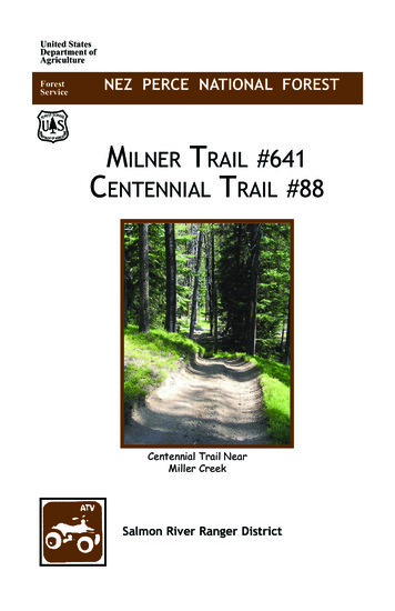
FORT KEARNY, June 3, 1849(From the sketch book of an unidentified artist accompanying the Mounted Riflemen. Photographcourtesy the Wisconsin State Historical Society.)
DEVELOPMENTS ALONG OVERLAND TRAIL163on the South Platte, was probably the builder of this post-2 8According to R. B. Sage, Fort Platte was a large post ofadobe, two hundred fifty feet long and two hundred feetwide. It consisted of twelve buildings which included ablacksmith shop, a warehouse, and a carpenter shop. Its staffof employees usually numbered thirty. 29By the summer of 1842 the fort had changed hands because, when Fremont reached it July 15, 1842, he reportedthe owners to be Sybille, Adams and Company. "The Pathfinder" wrote that the fort was "built of earth, and stillunfinished, being enclosed with w·alls (or rather, houses)on three of the sides, and open on the fourth to the river." 30In the summer of 1845 Fort Platte ceased to exist, forcedout by the competition of Fort Laramie, and as Hafen andYoung point out, this abandonment probably led to thebeginning of the short-lived Fort Bernard. Fort Platte's shellremained to attract emigrant attention, to serve as a landmark, and to draw comment. Parkman recorded seeing theremains of the adobe walls in 1846 and he pointed out thatthe post had been deserted because of the Laramie competitiors. 31William Clayton of the Mormon pioneers of 1847 alsoexamined the ruins after he crossed the Platte at Laramieand gave the dimensions of the enclosure as one hundredforty-four feet east to west, and one hundred three feetnorth to south. He also gave the wall measurements-elevenfeet high and thirty inches thick. 32 Whatever the discrepancies in measurements of the fort may have been, it mustcertainly have been spacious and well equipped; and duringits few years afforded some assistance to those traveling theOregon Trail.28Chittenden, op. cit., III, 967-968; Hafen and Young, op. cit.,p. 69.Hafen and Young, op. cit., pp. 72-73.John C. Fremont, Narrative of the Exploring Expedition tothe Rocky Mountains in the Year 1842, and to Oregon and NorthCalifornia in the Years 1843-44, (New York, 1846), p. 23.31 Parkman, op. cit., p. 108.32 William Clayton, Journal . . . (Salt Lake City, 1921), pp.208-209.2930
NEBRASKA HISTORY164A few minutes' travel beyond the site of Fort Plattestood the well-known and eagerly awaited Fort Laramie.Its first erection has been discussed, but its developmentand great importance deserves close consideration.On June 1, 1838, Myra Eells wrote:. Fort William . is a large, hewed log buildingwith an opening in the center; partitions for variousobjects. It compares very well with the walls of theConnecticut State Prison. A fort, in this country, is aplace built to accommodate the company as they go andcome from the mountains to trade with the Indians.33A year later F. A. Wislizenus described the post as,. . . a rectangle of about eighty by a hundred feet.The outside is made of cottonwood logs, about fifteenfeet high. . . . On three sides there are little towerson the wall that seem designed for watch and defense.In the middle a strong gate . Within, little buildingswith fiat roofs are plastered all around against the wall. the store house; another the smithy; the others aredwellings. . . .34It is probable that the building of Fort Platte helpedstimulate the rebuilding of Laramie into a more substantialpost. The logs were replaced with adobe and the place wasgiven a more permanent appearance. 33 Fremont wrote thatit had an "air of military construction" with "its lofty walls,whitewashed and picketed, with the large bastions at theangles . " 36Parkman devoted many pages of his Oregon Trail .todescription of Fort Laramie, its occupants, and its setting.Perhaps his most vivid and interesting writing about theoutpost was that in which he described the arrival of a trainof emigrants in 1846:. . . gaining a spot a quarter of a mile distant, theywheeled into a circle. For some time our tranquilitywas undisturbed. The emigrants were preparing theirencampment; but no sooner was this accomplished, thanFort Laramie was taken by storm. A crowd of broadbrimmed hats, thin visages, and staring eyes appearedsuddenly at the gate. Tall awkward men . . . ; womenEells, op. cit., pp. 73-74.F. A. Wislizenus, Journey to the Rocky Mountains in theYear 1839 (St. Louis, 1912), pp. 67-69.35 Hafen and Young, op. cit., pp. 69-70.36 Fremont, op. cit., p. 23.3334
DEVELOPMENTS ALONG OVERLAND TRAIL165with cadaverous faces and long lank figures, camethronging in together, and . . . ransacked every nookand corner of the fort . we withdrew in all speed toour chamber . hoping that it might prove an inviolable sanctuary. The emigrants prosecuted their investigations with untiring vigor. They penetrated the rooms . . . They explored the apartments. . . . Being totallydevoid of any sense of delicacy or propriety, they seemedresolved to search every mystery to the bottom.Having at length satisfied their curiosity . the menoccupied themselves in procuring supplies for theironward journey . . . buying them . . . or giving inexchange superfious articles of their own. 37Parkman pointed out that this behavior on the part of thepioneers did not bring good feeling between the personnelof the post and themselves. The fact that these people hadtraveled for hundreds of miles seeing few white faces otherthan those of their own party, and little in the way of settlement probably explains in great part why they acted asthey did upon arrival at Laramie.William Clayton, whose party of Mormon pioneers hadcome west on the Mormon Trail, visited Fort Laramie inJune, 1847. He was looking for a way to cross the Plattefrom the opposite bank and learned that a flat boat wasavailable for hire. The Mormons could either rent the boatfor fifteen dollars or they could pay a ferrying fee to thepost of twenty-five cents per wagon. Clayton went on to notethe following prices: one dollar for a pair of moccasins, onedollar for a lariat, a dollar and a half for a pound of tobaccoand thirty-two dollars for a gallon of whiskey. He also wrotethat the fort's spring supplies had not yet arrived, and consequently no sugar, coffee, or spices were available. 38In 1848 the Mormon emigration past the fort was heavyand approximately four thousand of them used Laramie asa way-station. 39 During that year Brigham Young conceivedthe idea that Mormon emigration should use Laramie as a"half-way station." He thought if loads were hauled toLaramie to be picked up there by teamsters from Salt Lake,teams would be saved. Those animals acclimated to lowaltitude and to high altitude could operate in their respec373839Parkman, op. cit., pp. 119-120.Clayton, op. cit., pp. 209-211.Hafen and Young, op. cit., p. 130.
NEBRASKA HISTORY166tive areas. This plan was followed for several years and FortLaramie had taken on another aspect for westward expansion.40One of the last adventurers to visit Fort Laramie as afur company post was Alonzo Delano. He arrived there onJune 12, 1849, and the white-washed walls were a welcomesight to him, and "the motley crowd of emigrants, with theirarray of wagons, cattle, horses, and mules gave a pleasantappearance of life and animation." He went on to say,Around the fort were many wagons . . . sold orabandoned by emigrants. A strong, heavy wagon couldbe bought for from five to fifteen dollars. In ordinaryseasons the company were able to keep some smallsupplies for emigrants, but such was the rush now, thatscarcely anything could be obtained,, even at the mostexorbitant prices. Here was a deposit for letters to besent to the States, and thousands left letters for theirfriends, to be deposited by a messenger in some postoffice beyond the Missouri, on which the writers paidtwenty-five cents. Although many of our companyplaced letters . . . not a single letter ever reached itsdestination. 41Here again in 1849 as in 1847 supplies which could havebeen sold to emigrants were not available. This situation wasalso reported by other passersby that spring. One wrote thatthe fort had nothing but buffalo meat for trade. 42 WilliamKelly, who was disappointed in what he found at Laramie,reported giving to the post personnel some supplies to tidethem over. Kelly's party did find the blacksmith shop awelcome facility for its use. 43 However untrustworthy theimprovised mail service may have been, many emigrantstook advantage of the opportunity to leave and to pick upmessages at the fort. HLate June of 1849 saw Fort Laramie's era as a fur company post come to an end, because it was purchased by theUnited States government and its administration was takenover by the Army. In 1842 Fremont had written that the fortIbid., p. 131.Alonzo Delano, Across the Plains and Among the Diggings(New York, 1936), p. 29.42 Geiger and Bryarly, op. cit., p. 10
the American Fur Company and the fort was soon Company property. It was renamed Fort John, but this title never did remain with the establishment. The term Fort Laramie was coming into common usage and it stayed with the fort from the beginning of the 1840's.3 The great numbers of emigrants did not begin to cover