Transcription
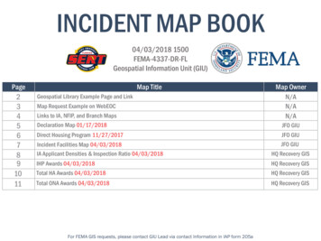
INCIDENT MAP BOOK04/03/2018 1500FEMA-4337-DR-FLGeospatial Information Unit (GIU)Page234567 Map TitleGeospatial Library Example Page and LinkMap Request Example on WebEOCLinks to IA, NFIP, and Branch MapsDeclaration Map 01/17/2018Direct Housing Program 11/27/2017Map OwnerN/AN/AN/AJFO GIUIncident Facilities Map 0 /2018IA Applicant Densities & Inspection Ratio 0 /2018JFO GIUJFO GIUHQ Recovery GISIHP Awards /2018HQ Recovery GISTotal HA Awards 0 /2018HQ Recovery GISTotal ONA Awards 0 /2018HQ Recovery GISFor FEMA GIS requests, please contact GIU Lead via contact Information in IAP form 205a
The FEMA WebEOC Geospatial Library containsnumerous Hurricane Irma map products.See Map RequestExample on Next Slideclickthe link
Map Request Example on WebEOC:Processi.ii.iii.iv.v.vi.vii.Sign into WebEOCSelect “Incident: R04 Hurricane IRMA R04 08-31-2017”Use the toggle on the top left of the screen to access the Geospatial LibrarySelect the “Request for Maps” tabSelect “Request a Map” on the far right of the screenFill out the required informationFollow up with an email to the JFO GIUiiiiiivv
Find additional maps at the following links:- i.e., county level and branch level mapsDamage Assessment mapsContrast Maps (DA/Apps/Insp)Individual Assistance (IA) Inspection Density mapsIndividual Assistance (IA) Individuals & Households Program(IHP) Awards mapsIndividual Assistance (IA) Applicant Density mapsBranch Maps are available in the WebEOC R4 - Hurricane IrmaGeospatial Library (look under the “Map Title” column)
FEMA-3385-EM-4337-DRIncident Period: 09/04/2017 alton eColumbiaLafayetteDixieDuvalBakerUnion ClayData Layer / Map Production:St. JohnsBradfordGilchrist AlachuaPutnamThe types of assistance that havebeen designated in the State of Florida.FlaglerLevyMarionAll designated areas in the Stateof Florida are eligible to apply for assistanceunder the Hazard Mitigation Grant ngeBrevardLegendPascoHillsboroughCurrent DeclarationsOsceolaPolkFEMA-DR-FL-4337 AMD DesotoIndianRiverIAPA Cat A-BIAPA Cat A-GSt.LuciePA Cat A-BMartinCharlottePA Cat A-GGladesHendryLeePalm BeachBrowardCollierMonroeMiami-DadeData Sources:FEMA, ESRI;FEMA-3385-EM-FLInitial Declaration: 09/05/2017FEMA-4337-DR-FLInitial Declaration: 09/10/2017Amendment 14: 1/10/2018037.575 MilesCoordinate System: GCS WGS 1984Datum: WGS 1984Units: DegreeData Sources:FEMA, ESRI, HSIPDocument Path: \\Jfgi3f11\gis share\Event \ FEMA-4337-DR-FL FEMA-3385-EM-FL\MXDs\Designated\DecMap 4337.mxd Document Name: DecMap 4337 User Name: jwoycke Date: 1/11/2018
Direct Housing IRU XUULFDQH ,UPDFEMA-4337-DREscambiaHolmesSantaRosa afayetteFranklinGilchrist AlachuaSt.JohnsData Layer / Map Production:PutnamDixieFlaglerLevyThis product illustrates the type of assistanceapproved for selected areas in the State of Florida. It includes counties approved for and participatingin Direct Housing IRU WKH XUULFDQH ,UPD HYHQW eSt. LucieHighlandsFEMA-4337-DR-FL- Disaster Declaration:09/10/2017Counties Approved for Direct Housing MartinGladesLeeDirect Housing: Available when applicants are unable to use RentalAssistance due to a lack of rental housing and other meansare exhausted.LegendHendryCollierPalm BeachBrowardMiami-DadeMonroeData Sources:FEMA, ESRI;FEMA-4337-DR-FLInitial Declaration: 09/10/2017Amendment 1 : 10/18/2017037.5Data Sources:FEMA, ESRI, HSIPUser Name: msmoot1Date: 11/27/2017Coordinate System: WGS 1984²75 Miles
Incident Facilities: sdenCalhounBayTallahasseeLeonField OfficeðCC nch ColumbiaSuwanneeHHUnionLafayetteBranch II! Office yPutnamGGGainesvilleField Office WildwoodField OfficeCitrusYMarionðÚLCC #17*ð#ÚNSarasotaJOsceolaIIIPalm Bayð FieldOfficeÚQIndian RiverOHardeeOkeechobeeHighlandsKPSt. LucieMartinCharlotteCharlotteLeeLFBranch IV!Office (Fort Myers)*LCC ##16Palm BeachDHendryLake Worthð Field OfficeÚMonroeMonroe!"Map Created: 4/3/2018LCCJFOStagingHaven III Training CenterOcala WarehouseIVVAdvisory Map PanelsVersionRevisedHomestead-MiamiSpeedway StagingOriginalBranchLCC #10States selection 2#*0User Name: ajone111#*#*# Field OfficeIIIB #*Division AOfficeEOCII#*LCC #8Branch V ! #*Office (Doral)LCC #14AðÚðÚðÚIMiami-DadeDC AtlantaDistributionCenterDivision OfficeBranchVCE!"DivisionBrowardCollierBranch OfficeTribe hFacility TypeBranch IIIOffice/JFO (Orlando)LakelandField OfficeManatee!(")OrangeðÚPinellasRO RegionIV Office!#Operational Period:0700 04/04/2018 to 0700 04/10/2018SSeminoleHernandoLargo Field MOfficeðÚVolusiaHolly Hillð Field OfficeÚLakeT SumterPascoThis product illustrates the OperationsPosture, as well as the Branch andDivision structure for federal assetsresponding to Hurricane Irma.FlaglerWUData Layer / Map Production:ZAlachuaDixieIICoordinate System: WGS 198445Data Sources:FEMA, ESRI90 MilesN
IA Applicants per 5KMFEMA-4337-DR-FL - Hurricane IrmaFloridaHolmesSantaEscambia onCalhounBayJefferson SuwanneeWakullaUnionBradford ClayLafayetteFranklinGilchristAlachuaSt.JohnsData Layer / Map Description:Individual Assistance Applicants (EOMMR)As of April 02, 2018Designated CountiesAs of April 03, umterHernandoSeminoleLegendOrangePascoDesignated Okeechobee LucieMartinGladesCharlotteLeeIAPANo DesignationIA Applicantsper 5KM1 - 849850 - 2955PalmBeachHendry2956 - 65906591 - 1305813059 - 39612BrowardCollierMiami-DadeMonroeIA Applicant Counts:Florida2,644,239FEMA-4337-DR-FLDeclared: Sep 10, 2017Incident Period: Sep 4, 2017 to Oct 18, 2017Amendment 14: Jan 10, 2018Data Sources:FEMA, ESRIMap created by: FEMA HQ Recovery GIS: FEMA-Recovery-Geo@fema.dhs.govPCS: WGS 1984 Mercator Auxiliary Sphere0153060Miles90N !
Total IHP Awards per 5KMFEMA-4337-DR-FL - Hurricane IrmaFloridaHolmesSantaEscambia onCalhounBayJefferson SuwanneeWakullaUnionBradford ClayLafayetteFranklinGilchristSt.JohnsData Layer / Map Description:AlachuaPutnamDixieIA Applicants as of April 02, 2018Designated Counties as of April 03, HernandoDesignated o teeHardeeSarasotaDeSotoSt.HighlandsOkeechobee LucieMartinGladesCharlotteTotal IHP Awardsper 5KM 108.52 - 477,326.39 477,326.40 - 1,637,106.21 1,637,106.22 - 3,752,179.60 3,752,179.61 - 7,329,683.13 7,329,683.14 - -DadeMonroeState IHP AwardsFloridaTotal IHP: 997,052,388Total HA : 690,721,307Total ONA: 306,331,080DISCLAIMER:Approved amounts are not reflective ofany adjustments to awards performedby FEMA Finance Center or US Treasury(e.g. Federal Debt, etc)FEMA-4337-DR-FLDeclared: Sep 10, 2017Incident Period: Sep 4, 2017 to Oct 18, 2017Amendment 14: Jan 10, 2018Data Sources:FEMA, ESRIMap created by: FEMA HQ Recovery GIS: FEMA-Recovery-Geo@fema.dhs.govPCS: WGS 1984 Mercator Auxiliary Sphere0153060Miles90N !
Total HA Awards per 5KMFEMA-4337-DR-FL - Hurricane IrmaFloridaHolmesSantaEscambia onCalhounBayJefferson SuwanneeWakullaUnionBradford ClayLafayetteFranklinGilchristSt.JohnsData Layer / Map Description:AlachuaPutnamDixieIA Applicants as of April 02, 2018Designated Counties as of April 03, HernandoDesignated o teeHardeeSarasotaDeSotoSt.HighlandsOkeechobee LucieMartinGladesCharlotteTotal HA Awardsper 5KM 482.48 - 294,021.86 294,021.87 - 1,058,802.57 1,058,802.58 - 2,578,227.73 2,578,227.74 - 4,690,937.55 4,690,937.56 - -DadeMonroeState IHP AwardsFloridaTotal IHP: 997,052,388Total HA : 690,721,307Total ONA: 306,331,080DISCLAIMER:Approved amounts are not reflective ofany adjustments to awards performedby FEMA Finance Center or US Treasury(e.g. Federal Debt, etc)FEMA-4337-DR-FLDeclared: Sep 10, 2017Incident Period: Sep 4, 2017 to Oct 18, 2017Amendment 14: Jan 10, 2018Data Sources:FEMA, ESRIMap created by: FEMA HQ Recovery GIS: FEMA-Recovery-Geo@fema.dhs.govPCS: WGS 1984 Mercator Auxiliary Sphere0153060Miles90N !
Total ONA Awards per 5KMFEMA-4337-DR-FL - Hurricane IrmaFloridaHolmesSantaEscambia onCalhounBayJefferson SuwanneeWakullaUnionBradford ClayLafayetteFranklinGilchristSt.JohnsData Layer / Map Description:AlachuaPutnamDixieIA Applicants as of April 02, 2018Designated Counties as of April 03, HernandoSeminoleDesignated lasHillsboroughNo t.HighlandsOkeechobee LucieMartinGladesCharlotteTotal ONA Awardsper 5KM 108.52 - 141,906.80 141,906.81 - 466,120.70 466,120.71 - 1,063,213.11 1,063,213.12 - 2,241,948.05 2,241,948.06 - DadeMonroeState IHP AwardsFloridaTotal IHP: 997,052,388Total HA : 690,721,307Total ONA: 306,331,080DISCLAIMER:Approved amounts are not reflective ofany adjustments to awards performedby FEMA Finance Center or US Treasury(e.g. Federal Debt, etc)FEMA-4337-DR-FLDeclared: Sep 10, 2017Incident Period: Sep 4, 2017 to Oct 18, 2017Amendment 14: Jan 10, 2018Data Sources:FEMA, ESRIMap created by: FEMA HQ Recovery GIS: FEMA-Recovery-Geo@fema.dhs.govPCS: WGS 1984 Mercator Auxiliary Sphere0153060Miles90N !
Data Layer / Map Production: Data Sources: FEMA, ESRI, HSIP Legend Counties Approved for Direct Housing User Name: msmoot1 Direct Housing: Available when applicants are unable to use Rental Assistance due to a lack of rental housing and other means are exhausted. FEMA-4337-DR-FL- Disaster Declaration:09/10/2017 Data Sources: FEMA, ESRI; FEMA .