Transcription
East Micronesian Cable Project (EMC)Addendum to Original Environmental andSocial Impact Assessment (ESMP) –Kosrae State FSM onlyWorld Bank Project No: P130592June 2020FSM CIU Safeguard TeamDepartment of Finance and AdministrationThis Environmental and Social Management Plan (ESMP) Addendum is a document of theborrower. The views expressed herein do not necessarily represent those of WB’s Board ofDirectors, Management or staff, and may be preliminary in nature.In preparing any country program or strategy, financing any project, or by making anydesignation of or reference to a particular territory or geographic area in this document, theWorld Bank does not intend to make any judgments as to the legal or other status of anyterritory or area.
OAEOPPCRPIAAffected PeopleAdministrative Project ManagerBeach Man HoleConservation AreaCentral Implementing AgencyCable Landing StationCentimetersDepartment of Transportation, Communication & Infrastructure –National GovernmentDepartment of Fisheries and Marine Resources – Kosrae StateDevelopment Review CommissionDepartment of Resource and Development – FSM NationalGovernmentDivision of Resource Economic AdministrationEnvironmental AssessmentEnvironmental Code of PracticesExclusive Economic ZoneEnvironmental Impact AssessmentEnvironmental Impact StatementEast Micronesian CableEmergency Response PlanEnvironmental and Social Assessment (WB)Environmental and Social Impact AssessmentEnvironmental Management PlanEnvironmental and Social Management PlanFederated States of MicronesiaFSM Telecommunications Cable CorporationGrievance Redress CommitteeGrievance Redress MechanismHectaresHazardous Substance Management PlanHealth and Safety PlanImplementing AgencyIndigenous PeoplesIndigenous Peoples PlanIndigenous Peoples Planning FrameworkKosrae Island Management Resources AuthorityKosrae Conversation & Safety OrganisationKilometersMetersMeters squaredManagement Committee (EMC)Marine Protected AreaMarine Resources Division FSM National GovernmentNational Biodiversity Strategy and Action PlanNautical MilesNational Oceanic Resource Management AuthorityOpen Access EntityOperational Policy (WB)Physical Cultural ResourcesProject Influence AreaEast Micronesian Cable Project – ESMP Kosrae Component Addendum Update – June 20202
PMUPPERAPRPFTMPTPMTORWBWWPWWIIUXOProject Management UnitPersonal Protective EquipmentResettlement Action PlanResettlement Policy FrameworkTraffic Management PlanTechnical Project ManagerTerms of ReferenceWorld BankWaste Management PlanWorld War TwoUnexploded OrdnancesLIST OF FIGURESFigure 1:Figure 2:Figure 3:Figure 4:Figure 5:Figure 6:Figure 7:Figure 8:Figure 9:Figure 10:Figure 11:Figure 12:Figure 13:Figure 14:Figure 15:Figure 16:Proposed submarine cable alignment connection for the island nationsof Kosrae (FSM), Nauru and Kiribati (adopted from the original ESIA).Typical layout of a beach manhole landing facility.Fibre optic cable options.Examples of a submarine cable ploughs used in tropical waters.Schematic showing typical conduit thrusting methodology.Proposed Shallow Water Marine Cable Alignment.Proposed Terrestrial Cable Alignment.Proposed Location of the Cable Landing site and BMH.Photos of the Proposed BMH Site.New Site Location for the projects Cable Landing Site.Photos of the Proposed CLS Site.The location of the marine assessment survey sites including the 6Dive Sites (SD) and the 4 specific Free Dive intertidal and subtidal reefsystems (red) in relation to the Lelu channel and proposed cablealignment (not to scale).The location of the 6 intertidal reef transects in relation to the Leluchannel and the proposed cable alignment (not to scale).Location of the sunken vessel and planes within Lelu Harbor.Representative photos of the road easement associated with the fibercable terrestrial alignment, (a) road in close proximity to BMH, (b) roadin close proximity to the CLS, (c and d) main bridge and (e & f) coastalshoreline.Proposed cable alignment showing area that requires UXOassessment.LIST OF TABLESTable 1:Table 2:Table 3:Relevant National and State Legislation for Kosrae.Project Area of Influence delineations and conditions.Summary and continued relevance of the original ESIA annexes.East Micronesian Cable Project – ESMP Kosrae Component Addendum Update – June 20203
Table of Contents1. INTRODUCTION . 81.11.21.31.4Proponent and Purpose of ESIA . 8Project Rationale . 9Project Status & Documentation . 9ESIA Methodology .102. POLICY, LEGAL AND ADMINISTRATIVE FRAMEWORK . 112.1 Resource Management .112.2 Land and Tenure .122.3 Legal Framework .132.4 International and Regional Treaties .142.5 World Bank Safeguard Instruments .143. PROJECT DESCRIPTION. 173.1 Project Components .173.2 Project Description .194. BASELINE DATA . 244.14.2Marine Assessment.24Terrestrial Assessment .315. ANALYSIS OF ALTERNATIVES . 346. ANTICIPATED IMPACTS AND MITIGATION MEASURES . 356.1 Introduction .356.2 General Environment .356.2.1 Deep Ocean Waters . 356.2.2 Intertidal Coastal Marine Areas . 366.2.3 Terrestrial Areas . 376.3 Poverty and Gender Impacts .386.4 Land Acquisition & Resettlement .386.5 Risk Assessment & Impact Identification Methodology .396.6 Outcome of Risk Assessment & Impacts Identification.396.7 Other Potential Impacts & Benefits .396.7.1 Cumulative Impacts . 396.7.2 Irreversible & Irretrievable Impacts . 406.7.3 Transboundary Impacts . 406.7.4 Environmental & Social Enhancements/Benefits . 407.0 INFORMATION DISCLOSURE, CONSULTATION & PARTICIPATION. 417.1 Introduction .417.2 Disclosure .427.6 Ongoing Consultation & Participation .428 ENVIRONMENTAL & SOCIAL MANAGEMENT PLAN . 438.1 Introduction .438.2 Performance Indicators.438.3 Implementation Arrangements .448.3.1 Overview. 448.3.2 ESMP Implementation Arrangement . 458.4 Institutional Capacity Assessment.458.5 Mitigation & Monitoring .468.5.1 Environmental. 468.5.2 Social Development Programs & Resettlement Costs. 478.5.3 Total costs . 47East Micronesian Cable Project – ESMP Kosrae Component Addendum Update – June 20204
8.6 Reporting & Monitoring Requirements .478.6.1 Environmental Codes of Practice . 479.0 GRIEVANCE REDRESS MECHANISM (GRM) . 4810.0CONCLUSIONS & RECOMMENDATIONS . 4911.0 APPENDICES – UPDATED ESMP . 52ANNEX 11.1 Ownership Documents of the Proposed Beach Man Hole (BMH),Sansrit School, Kosrae. .52ANNEX 11.2 Ownership Documents of the Proposed Cable Landing Site (CLS) inKosrae. .54ANNEX 11.3 Chance Find Procedure. .56ANNEX 11.4 The Kosrae Components Grievance Redress Mechanism (GRM). .57ANNEX 11.5 Environmental and Social Impact Mitigation and Monitoring TableUpdated for Kosrae Component Only – Marine and Terrestrial Cable Alignment Scope of Works.61East Micronesian Cable Project – ESMP Kosrae Component Addendum Update – June 20205
EXECUTIVE SUMMARYThe Governments of the Federated States of Micronesia (FSM), Kiribati and Nauruhave secured their joint participation in a regional fibre optic cable system to link theFSM island state of Kosrae, and the island nations of Kiribati and Nauru, to theexisting Hannon‐Armstrong (HANTRU)‐1 cable, which currently connects the FSMstates of Pohnpei and Chuuk to Guam. The proposed multi‐national cable system isknown as the East Micronesia Cable (EMC).The Government of FSM has received assistance from the World Bank (WB) througha grant “East Micronesian Cable” (EMC) project to provide a submarinetelecommunication fibre optic cable. The Kosrae submarine cable alignment hasbeen finalised and will originate from a submarine branch line connected to the EMCoffshore from the island of Pohnpei southwest to Kosrae. The agreed submarinecable alignment for the island of Kosrae is to enter the natural deep water reefpassage and channel through the islands outer barrier reef entering Lelu harbor. Itthen is to follow the channel veering south entering the shallow subtidal and intertidalwaters on the southern side of the harbor. The cable will terminate (Beach Man Hole- BMH) on the southern shoreline at the Sansrit school (5019’13.27N and163001’33.04E), which is located on reclaimed state government land. The terrestrialcomponent of the cable alignment will be deployed underground within the Kosraestate road easement to terminate at the projects Cable Landing Site (CLS) locatedwithin Tofol on government land within an existing building complex.An Environmental and Social Impact Assessment (ESIA) was developed for theoriginal project, including the three nations associated within the EMC that provided apreliminary assessment of the potential impacts and mitigation options associatedwith this project. Final site specific deep sea submarine, shallow water and terrestrialcable alignment locations were unknown at the time the assessment wasundertaken. Subsequently, through further data collection and stakeholderdiscussion the cable alignment for Kosrae state has been finalised.Thus this report provides an addendum to the projects original ESIA including sitespecific shallow water marine and terrestrial ecological and social data assessmentwhich provides an updated Environmental and Social Management Plan (ESMP) thatspecifically addresses the potential risks associated with the delivery of this project.This information is reported herein and is to be read in conjunction with the EMCprojects original ESIA report for the Kosrae component only. The original ESIA reportstructure and information relevant to the Kosrae Addendum has been included hereinand up dated as required.Information detailed within this addendum has been incorporated into a Kosraespecific Environmental Management Plan (EMP) based on the original projects EMPto further strengthen the environmental management of the open ocean (deep sea),shallow water and terrestrial ecological systems potentially impacted by the cabledeployment.The marine ecological assessment of Lelu harbor identified the potential ofUnexploded Ordnances (UXO) resulting from World War Two (WWII) within thedirect area of influence for the submarine cable alignment within the shallow watermarine areas (Lelu channel through to BMH) and as such a professional assessmentof their presence needs to be undertaken to ensure impacts from UXO are knownand managed.East Micronesian Cable Project – ESMP Kosrae Component Addendum Update – June 20206
The EMC Kosrae subcomponent project will require limited land based infrastructure,resulting in minimal localized terrestrial and marine‐based impacts, which are limitedin scale (immediate footprint of the works) and extent and can be fully mitigated if theprojects EMP compliance is maintained. There are no threats to the area’s marine,coastal and terrestrial biodiversity associated with the project. As such the potentialimpacts of the works on these environment are considered to be minor, temporary,mitigatable and overall insignificant.There will be no involuntary land acquisition and all land utilized within the project isgovernment owned and/or leased and within designated official easements (road).The submarine cable will affect a corridor no more than 3 m wide on the sea floor inthe open ocean and nearshore coastal zone.Given the small‐scale impact of the marine work, and the fact that nearly all of thework is on board a vessel at sea, no negative social impacts are expected. Sensitivedeep water marine ecological sites such as sea mounts and hydrothermal vents willbe avoided to protect the cable and avoid potential environmental impacts. Similarly,specific cable alignment corridor has been developed for the inshore shallow water toensure impacts to the subtidal and intertidal coral reef and sea grasses ecosystemsare negated.The construction of the BMH facility on land and the deployment of the terrestrialcomponent of the cable to the CLS will require a sub‐contractor. Key potential impactrelates to the disturbance to road users and adjacent land uses from the microtrenching of the cable within the Government owned road easement. Specific socialand environmental mitigation and monitoring activities have been included in theupdated EMP to ensure the management of these activities.East Micronesian Cable Project – ESMP Kosrae Component Addendum Update – June 20207
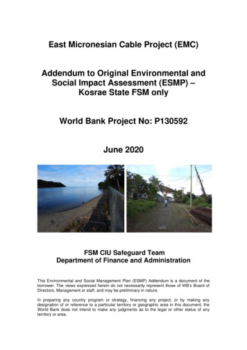
1. INTRODUCTION1.1 Proponent and Purpose of ESIAThe Government of the Federated States of Micronesia (FSM) has securedassistance with funding from the World Bank (WB) for a regional fibre optic cable tolink the FSM State of Kosrae, and the island nations of Kiribati, and Nauru, to theexisting Hannon‐Armstrong (HANTRU)‐1 cable (Figure 1) which currently connectsthe FSM States of Pohnpei and Chuuk to Guam.The FSM Department of Transportation, Communication & Infrastructure (DTC&I)remains the Implementing Agency (IA) for the Kosrae component of the EMC. Thenewly developed FSM Telecommunications Cable Corporation (FSM TCC) known asthe Open Access Entity (OAE) will implementation the project on behalf of DTC&I.One of the main challenges facing the region is the need to overcome its remotenessand dispersed geography by developing infrastructure to connect peopledomestically and internationally. The EMC Project is intended to provide essentialbackbone infrastructure to promote and support social and economic developmentacross all sectors in each country and within the region. The long term viability of theregion hinges on domestic and international economic integration. The new fiberoptic cable procured under the EMC project will connect the Pohnpei Spur to Kosraeand on to Nauru terminating in Kiribati. The length of the new cable will beapproximately 2,000 kilometers (km). A significant portion of the cable is well beyondthe territorial seas of the participating countries. The original Environmental andSocial Impact Assessment (ESIA) and the Environmental and Social ManagementPlan (ESMP) addendum update (this report) have been prepared to identify allpotential environmental and social impacts that may arise as a result ofimplementation of the project and to mitigate any impacts, with a focus on deep sea,nearshore marine, coastal zones and terrestrial systems which form the ProjectInfluence Area (PIA). Terrestrial infrastructure is relatively limited in extent andutilizes existing government owned infrastructure, facilities and rood easements.Figure 1: Proposed submarine cable alignment connection for the islandnations of Kosrae (FSM), Nauru and Kiribati (adopted from the original ESIA).East Micronesian Cable Project – ESMP Kosrae Component Addendum Update – June 20208
1.2 Project RationaleThe proposed project will support investment in a submarine fibre optic cable thatwould connect Kosrae, with Pohnpei to Guam and from there to the rest of the worldvia the global Internet. At present, Kosrae relies entirely on satellite for Internetconnectivity. The high cost, and the variable and limited availability of internationalbandwidth are major constraints to their ability to participate in the global Informationage and the concomitant opportunities for economic and social development thatarise when cheap and accessible high speed Internet services are made available.The proposed project will contribute to improved public services (including onlinegovernment services such as health, education and financial services), will supportthe tourism sector, and will facilitate better trade and communication among northPacific island economies.1.3 Project Status & DocumentationAt the time of preparation of this document (addendum), a project plan for thedelivery of the submarine cable to the island of Kosrae through to the terrestrialCable Landing Site (CLS) has been agreed and finalized. As such this addendumhas been designed to update the project original ESIA to reflect the updated projectinformation. The addendum update uses the WB Environmental and SocialAssessment (ESA) policy framework.As identified in the original ESIA, a site specific marine benthic ecologicalassessment of the shallow waters associated with the Lelu harbor cable alignment(December 2019) was undertaken. This report documents the marine ecological andenvironmental parameters persisting at this proposed shallow water site andprovides clear impact mitigation and management mitigation methods that have beenincorporated into the projects updated ESMP to ensure the management andmitigation of these impacts. The report is presented separately to this addendum.The original land due diligence assessment remains relevant to the project, albeitmuch of the previous information in not specifically relevant to the final alignment site.East Micronesian Cable Project – ESMP Kosrae Component Addendum Update – June 20209
Kosrae state government land ownership of the BMH and CLS are provided in Annex1 and 2, respectively.1.4 ESIA MethodologyThe original ESIA included the following methodology: An initial evaluation of potential cable alignments was undertaken based on incountry consultations with officials from the respective Governments. Then,further scoping activities were undertaken to evaluate these locations basedprimarily on eliminating the requirement for private or custom owned landacquisition and minimizing coastal zone environmental impacts. This initialscoping exercise identified a number of BMH sites and CLS that facilitatedthe completion of the evaluation for this ESIA.In addition, the original ESIA assessment included a review of relevantsecondary information sources, site visits, key stakeholder interviews, andpublic consultations to determine existing environment conditions in the PIAcorridor, at BMH sites and along landside routes where cables may belocated. This was followed by an analysis of the potential impacts that theinstallation and operation of the fibre optic cable could have on the corridor’snatural and socio‐cultural environment. Data collected included the following: Potential land acquisition requirements; Sensitive environmental receptors within the PIAs, includingConservation Areas, FishAttraction Devices (FADs) and specialtourism sites, such as dive sites; Marine ecology of the coastal zone and nearshore waters likely affectedby the cable project, including benthic and coral reefs conditions alongthe PIA corridor; Poverty and gender conditions in relation to the proposed work; Social impacts of faster and more reliable Internet connections; and Cultural heritage and archaeological sites within the PIA corridor.Preliminary evaluation of the marine and terrestrial ecological resources wasundertaken in late October and early November 2016 and documented in anecological assessment report. Information obtained was then used to assesspotential environmental impacts and identify potential mitigation optionsduring cable deployment and included in the original ESMP.The methodology used to update the original baseline information and subsequentmitigation and management protocols have been included in this addendum. Theresulting ESMP developed herein is based predominantly on the ecological andsocial baseline data collected during the addendum preparation, with a largeproportion based on the marine ecological assessment undertaken in November2019. The marine ecological assessment report is a standalone report and shouldbe referred as required.East Micronesian Cable Project – ESMP Kosrae Component Addendum Update – June 202010
2. POLICY, LEGAL AND ADMINISTRATIVE FRAMEWORK2.1 Resource ManagementThe original ESIA provides a detailed account of the state government and as such isrepeated below. Changes that have been made have been inserted directly into thetext to reflect recent name changes of a number of agencies.There are a considerable number of government and semi‐government agenciesinvolved with marine resource management at national and state levels in the FSM.Each State operates independently in fisheries matters within State territorial waters(shoreline out to 12 nautical miles).The FSM Government’s Marine Resources Division (MRD) of the Department ofResources and Development (DR&D) is responsible for providing the government(national and state) with technical information, advisory services and support fordevelopment and management activities in marine resources including fisheries,aquaculture and coastal resource management. It is additionally responsible for non‐living marine resources within the 200 nautical mile (nm) Exclusive Economic Zone(EEZ). A major function is to liaise with foreign and international agencies concerningmarine resources.The FSM National Oceanic Resource Management Authority (NORMA) has beenestablished to regulate the use of and to manage and conserve the resources withinthe nations 200 mile EEZ. One of the NORMA’s key functions is to adopt andpromulgate regulations for the conservation, management, and exploitation of allliving resources in the EEZ.In Kosrae, the Department of Fisheries and Marine Resources (DFMR) under theDivision of Resource Economic Administration (DREA) is the state agencyresponsible for the management and development of marine resources. The KosraeIsland Management Resources Authority (KIRMA) is the state agency responsible forassessments relating to land usage, permitting for developmental programs,identification of Conservation Areas (CA), enforcement, development ofenvironmental regulations, and development and implementation of environmentalmanagement plans. An Environmental Impact Assessment (EIA) is required to beEast Micronesian Cable Project – ESMP Kosrae Component Addendum Update – June 202011
prepared (Section 19.104 of the State Code) if a development or activity affects “theenvironmental quality of fishery waters”.The Kosrae Conservation and Safety Organization (KCSO) is a non‐governmentalorganization whose purpose is “to further develop projects relating to awareness andprotection of the natural environment and to public health and safety; to conductcommunity programs and related programs applicable to these projects withinKosrae .”The Kosrae National Biodiversity Strategy and Action Plan (NBSAP) outlines thestate of the nation’s biological resources and the current biological and human‐related threats that affect there continued existence.2.2 Land and TenureThe State Government controls a major part of the land in Kosrae, namelygovernment owned lands, mangrove areas, nearshore areas, and lagoon areas.Primarily, government lands are of the interior, above the “Japanese line” 1 andforeshore areas. Kosraean’s can own land but not outsiders (foreigners). The land isowned in “Fee Simple” with a certificate of title issued when the registration processis complete for individual landowners. However, if the land is inherited by multipleheirs or if customary family land is held in common, then a Tenancy in Common titleis issued.Accessing land through usufruct or access rights (customary practice) was commonfor hunting or gathering purposes. Nowadays, this is more common in the upland andgovernment ownedareas. Accessing land and use rights for productive lands,particularly in settled areas, is done through leasing agreements.As a protectorate measure, foreign ownership of land is through leasing titles only.Kosrae state law allows locals and foreigners alike to lease for up to a 55‐year termrenewable for an additional 55 years. Although this provides secure access and usefor the lease period, issues such as land ownership disputes, lack of certainty, poorsurveying capabilities, absence of records, and uncertain parameters for customaryusage often hinder foreign investment. As in other Pacific island land tenure systems,land transactions are often made under customary practice, which is frequentlyundocumented. This makes accurate determination of ownership rights and pricing ofland difficult to determine.The Kosrae constitution is the primary rule of law in the State of Kosrae. In itspreamble, it declares “Kosraean’s are one, as people, in their language, in theirtraditions, and in their family and communal life”. The Preamble acknowledges thebounty and beauty of Kosrae pledging to preserve those natural riches. Thus thelegal foundation for the State’s environmental protection and conservation, bothhuman and physical, is laid.The Kosrae State Code Title 11, Land and Environment, sets out the requirementsregarding the acquisition and use of land. Under Title 11, the Governor can transfertitle or interest in public land on behalf of the State of the Government but only withthe Legislature’s resolution. The Governor also has the authority to designatesuitable areas of the public land for homesteading to eligible persons.1A line which sets aside the upper elevation of Kosrae Island; land above the line is designated as Government andthe land below the line is where private owned designated begins.East Micronesian Cable Project – ESMP
states of Pohnpei and Chuuk to Guam. The proposed multi‐national cable system is known as the East Micronesia Cable (EMC). The Government of FSM has received assistance from the World Bank (WB) through a grant "East Micronesian Cable" (EMC) project to provide a submarine telecommunication fibre optic cable.