Transcription
East Micronesian Cable (EMC) ESMP UPDATE - Kosrae Component OnlyThe below information has been developed to ensure the existing Kosrae componentof the EMC project’s ESMP reflects the final scope of work for both the delivery of themarine (ocean through to the Beach Man Hole – BMH) and terrestrial (BMH throughto the Cable Landing Site – CLS) components. The original project ESMP did notinclude the terrestrial component.The original project ESMP information is to be used unless updates are includedbelow. Information pertaining to Kiribati and Nauru are outside of this review.Executive Summary:Original Summary is suitable with the direct findings and impacts relevant to theproject.Two suggested up dates are recommended for inclusion:Paragraph 4 should be replaced with the following: The agreed submarine cable alignment will originate from a southern branchline from the Pohnpei to Kiribati cable line (EMC) located to the northeast ofKosrae. The agreed submarine cable alignment for the island of Kosrae is toenter the natural deep water reef passage and channel through the islandsouter barrier reef entering Lelu harbor. It then is to follow the channel veeringsouth and enter the shallow subtidal and intertidal waters on the southernside of the harbor. The cable will terminate (Beach Man Hole) on the southernshoreline at the Sansrit school (5019’13.27N and 163001’33.04E), which islocated on reclaimed state government land. The terrestrial component of thecable alignment will be deployed underground within the Kosrae state roadeasement to terminate at the projects Cable Landing Site (CLS) located withinTofol on government land within an existing building.Paragraph 5 should include: Additional risk assessment for the presence of Unexploded Ordnances (UXO)within the direct area of influence for the submarine cable alignment within theshallow water marine areas (Lelu channel through to BMH) needs to beundertaken to ensure impacts from UXO are known and managed.1.0 Introduction:All sectors remain relevant. Section 1.4 should include (an addition to the second lastparagraph):A second in-depth site specific marine benthic ecological assessment of theagreed shallow water (coastal) submarine cable alignment was undertaken inNovember 2019 to identify marine ecology and habitats present within theproposed cable alignment with recommendations provided for inclusion intothe projects existing EMP. The assessment was developed as a stand alonereport.2.0 Policy, legal and Administrative Framework: No changes are recommended, however the below items clarify a number of issues. Kosrae State – section 2.1, 2.1.1 (third paragraph) is out dated information(e.g. Micronesian Maritime Authority (MMA) is the National Oceanic ResourceManagement Authority (NORMA) – this change was effective years (10)before this document was written? This needs to be replaced with: NationalFinal Draft - East Micronesia Cable (EMC) – Updated ESMP (February 2020)1
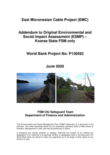
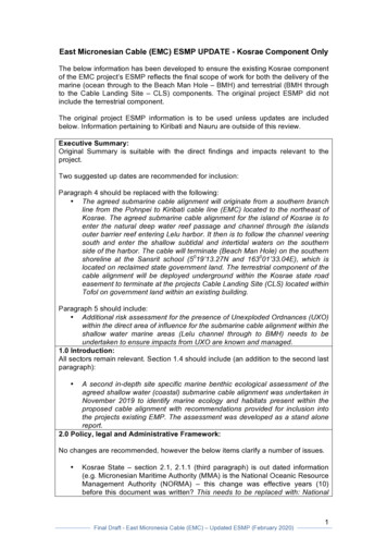
Oceanic Resource Management Authority (NORMA) should replace MMAreferences within the text.Fourth paragraph - The Kosrae Marine Resources is now a DepartmentFisheries and Marine Resources (DFMR) under Division of ResourceEconomic Administration (DREA). This should be replaced to reflect thecurrent status.Section 2.5.2 Kosrae & Kiribati - The Kosrae project remains a category Band the original safeguard policies and instruments – as described remain thesame. This includes: OP 4.01 (Environmental Assessment); OP 4.04 (NaturalHabitats); OP 4.11 (Physical Cultural Resources).3.0 Project Description:The below information should be included to reflect the further development of theprojects specific cable alignment and locations of the Beach Man Hole (BMH) andCable Landing Site (CLS).The final cable alignment has been agreed. The submarine cable is to pass throughthe Lelu channel (eastern side of the island) entering Lelu harbor and land at aBeach Man Hole (BMH) at the Sansrik Elementary School (BMH6 site). The cablesterrestrial alignment is to follow the island main road (within the easement through toa new agreed Cable Landing Site (CLS) located to the east of the original suggestedsite (Figure 1). All terrestrial delivery system components will be located within stateowned/leased land and remain within the states road easement.Figure 1: Proposed cable alignmentFinal location of the shallow water cable alignment, BMH position, road easementlocation will be determined once technical contractors have evaluated the project andprovided final deployment sites. Precautionary notifications highlighted in the originalESMP are to be followed.CLS Location Changed: The CLS no longer is to be located within the FSMTelecommunications Corporation Earth Station in Tofol as describe in the ESMP, it isFinal Draft - East Micronesia Cable (EMC) – Updated ESMP (February 2020)2
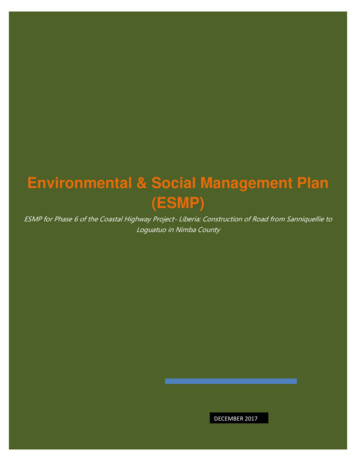
now to be located at the “old Telecom site’ located on government land directly eastof the police-goal, within Tofol (refer Figure 2). The site is owned by the stategovernment (Annex 1).Figure 2: New site location of the CLS.The new CLS site is elevated, fully fenced, contains 3 main buildings in various levelsof disrepair, an old currently unused satellite dish, various equipment currently storedon site and has direct access to the main road via a gravel driveway with anapproximately length of 50 m (55 yards). The fenced land parcel has a perimeter of155 m (170 yard) and an approximate land area of 1,492 m2 (1,884 yard2).The site has been cleared of original vegetation during the 1960’s and remains ahighly disturbed land parcel. No natural flora and fauna exists (refer Figure 2 andphotos below).Final Draft - East Micronesia Cable (EMC) – Updated ESMP (February 2020)3
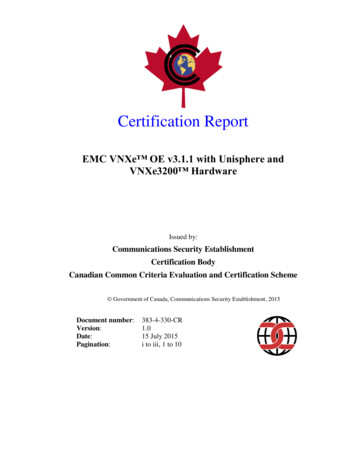
BMH: The location of the Beach Man Hole (BMH) remains the same – SansrikElementary school land parcel and access road are located on State governmentowned land with direct access to the road easement through government land(Annex 2 – ownership documents) (Figure 3).Figure 3: Location of the BMH.Final Draft - East Micronesia Cable (EMC) – Updated ESMP (February 2020)4
The site is located on the foreshore and intertidal reclaimed reef flat, fully fenced,contains 3 functioning school classroom buildings and associated infrastructure andhas direct access to the main road via a gravel drive way with an approximatelylength of 30 m (33 yards). The fenced land parcel has a perimeter of 128 m (250yard) and an approximate land area of 3,815 m2 (3,190 yard2).The site has been reclaimed and cleared of original vegetation during the 1960’s andremains highly disturbed land parcel. No natural flora and fauna exists (refer photosbelow).Final Draft - East Micronesia Cable (EMC) – Updated ESMP (February 2020)5
The site is owned by the state government (Annex 2).Section 3.2.1 Submarine Component. This in part is out dated as the additionalmarine assessment of the shallow water cable alignment has been completed.However, this section should remain, as it was correct at the time of the originalESMP. The marine assessment undertaken in November 2019 is referred to in anadditional section of the report (see below) and thus reflects the final agreedalignment and subsequent impacts and mitigation required.4.0 Baseline Data:Baseline Data Report: Annex 1 in the original reportAnnex 1: Provides a very general summary of biological – ecological attributes ofFinal Draft - East Micronesia Cable (EMC) – Updated ESMP (February 2020)6
Kosrae (as required by the original TOR). However there is very limited informationprovided on the preferred shallow water marine and terrestrial sites within theprojects area of Influence associated with the proposed cable alignment path. Thusvery limited information is available (reported) to ensure key significant biologicalresources (flora and fauna) and ecological systems are not impacted due to thescope of works. This is essential information to ensure WB safeguard requirementsare met.The ESMP report specifies the “cable contractor” will undertake and complete thedetailed marine assessment of the final cable alignment route. This is somewhatconfusing.The cable contractor is required to undertake a bathymetric survey-assessment ofthe deep water environments to ensure cable alignment meets the requirementsdetailed in the ESMP (distances from seamounts etc) (see comments below on table4.1) and similarly bathymetric assessment of the cable alignment when entering Leluharbor through to the BMH (the agreed final cable alignment). However, the cablecontractor needs to be guided by the ESMP and specific information in the projectsEMP on the inshore benthic habitat that they can and cannot enter. As such toensure the project ESMP meets these requirements a marine benthic biologicalresource and abiotic assessment needs to be undertaken and findings provided tothe cable contractor before they initiate their work. As such a marine benthicresource and substrate assessment was undertaken and completed in November2019. This report was developed as a standalone document and should be referredwhen information is required. The report documents key findings of the assessmentand recommendations to be included in the EMP.Key findings of the marine assessment include; Potential Impacts: The impacts derived from the marine scope of works areexpected to be very minor, localized to the immediate footprint of the works,and easily managed through standard engineering good practice mitigationmeasures. There are no threats to the area’s marine and coastal biodiversityassociated with the project. As such the potential impacts of the works on themarine environment are considered to be minor, temporary, mitigatable andoverall insignificant. Mitigation Measures: Recommended mitigation measures during theconstruction phase of the project should include; (i) Deploy silt curtain/saround the termination location (shoreline adjacent to the BMH) of thesubmarine cable during all construction and redevelopment activities todirectly manage and reduce the dispersion of benthic substrate (silt) disturbedduring construction, and (ii) Ensure due diligence when operating machineryduring all work activities to prevent and manage petrochemical spillage andcontamination of the waters associated with the project.The overall potential impact of the works on the marine biologicalenvironment is expected to be minor, localized and overall insignificantprovided standard mitigation measures associated with good engineeringpractice as identified above are implemented. Furthermore due to the natureof potential minor impacts of the scope of works it is recommended that nospecific marine monitoring program is required other than close supervision ofthe works to ensure that the above recommended mitigation measures areFinal Draft - East Micronesia Cable (EMC) – Updated ESMP (February 2020)7
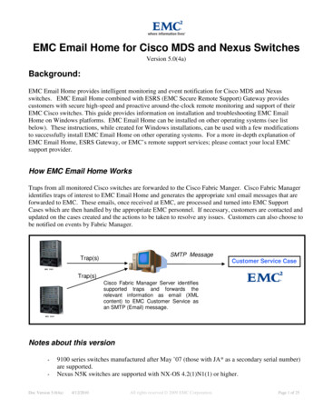
implemented and effective throughout the marine construction works.Unexploded Munitions – UXOSpecific Comments on Section 2.8 in the Ecological Baseline Data Report (Annex 1).This section states:“All three countries have significant World War II histories. Although the risk isconsidered low, due diligence and careful consideration will be needed during nearshore stages of cable deployment to ensure that the presence of unexploded WW IIammunition, that may be presently buried in the substrate for Kosrae, Kiribati andNauru and if present is removed”. The document further states “A detailedassessment of the cable alignment will need to be undertaken during the surveyassessment to ensure unexploded munitions UXO are located and removed beforethe cable is deployed”.The marine assessment details the past history (literature review and stakeholderconversations) of WWII activities within Lelu harbor and concluded that the is apotential issue with UXO within the submarine cable Area of influence –recommending a risk assessment be undertaken to identify this issue and mitigationactivities. This assessment needs to be undertaken before the cable is deployed.Summary of UXO in Lelu harbor (from the marine assessment) and need to beincluded in the up date projects ESMP include.Background historical references and discussions with local dive industry, marineresources and stakeholders in Kosrae clearly indicated that Lelu harbor during WWIIreceived in the order of 30 tons of bombs from American aircraft. The bombing ofLelu left the island and foreshore demolished and included the sinking of theJapanese navy cargo ship “Ebon Maru” which remains on the bottom within the Leluharbor. As such all anecdotal discussion with key stakeholders indicated that there isthe possibility that UXO remain within the Lelu harbor area and that no past marineidentification and removal has taken place within the harbor. WW II equipmentincluding UXO has been removed from the Lelu Island shoreline and interior.Therefore, due diligence and careful consideration needs to be undertaken during allstages of cable deployment from the entrance of the Lelu harbor through to thebeach man hole (Sansrit school) for the possible presence of unexploded WWIIammunition, that may be present in the substrate.It is recommended that a detailed assessment of the cable alignment be undertakenduring the initial cable bathymetric survey assessment undertaken by the contractorto ensure unexploded munitions are located and removed before the cable isdeployed. This is essential if cable trenching will be undertaken within the harbor.Potential impacts decrease if the cable is laid on the sea floor and trenching is notundertaken.Moreover, resting on the sea floor within Lelu harbor are two aircrafts (PBM Marinercrashed 1951 and a Navy plane (HU-16) crashed in 1972) and 3 ships including awhaling ship (they think was the “MV Waverly”) reported sunk in 1836, Japanesecargo vessel (Ebon Maru) sunk in 1945 and an unknown vessel. Both planes and allvessels are located on the sea floor on the north western side of the harborsubmerged coral island in the center of the harbor – towards the Lelu dock (Figure5). All are located well outside of the projects area of influence and as such will notbe impacted by the project.Final Draft - East Micronesia Cable (EMC) – Updated ESMP (February 2020)8
Figure 5: Location of the sunken vessels and planes Lelu harbor.The ESMP has very limited information detailing the terrestrial flora associated withthe proposed cable alignment (school BMH through to the new CLS). This is notsignificant to the ESMP as the alignment will be within the road easement however –there are a number of plants – trees that have encroached onto the road easementthat may be required to be removed. This is dependent on the side of the road thecable will be deployed (assuming it will be under ground). Road easement cleaningof vegetation occurs periodically by the state (road cleaning), telecommunication,water, power providers and landowners. Removal of this vegetation, predominatelygrass and weeds (non natives) encroaching on the rood corridor is supported andacceptably activities and as such general stakeholder discussion indicated that this isfully accepted as part of the road easement arrangements. If large vegetation (e.g.trees) are required to be removed then specific discussions need to be undertakenwith the land owners adjacent to the road corridor. Several pictures of the road areincluded below.In addition, the terrestrial cable deployment route includes several areas that are inclose proximity to the coastal shoreline (within the road corridor) and crosses severalsmall streams. Consideration of the position of the cable (if underground) needs to bemindful of these habitats and long term potential negative impacts of climate change.Final Draft - East Micronesia Cable (EMC) – Updated ESMP (February 2020)9
Baseline 4.0 – Table 4.1 Project Influence areas delineations and conditions.This table remains suitable for the area of influence.5.0 Analysis of AlternativesAll remains relevant – proposed site has been identified. No changes.6.0 Anticipated Impacts & Mitigation MeasuresThis section is based on expected impacts, which are suitable, however additionalsite specific information resulting from the marine assessment is required to beincorporated into this document. This changes the impacts as they reflect on actualissues not perceived impacts as documented in the original ESMP.6.2 General Environment6.2.1 Deep Ocean Waters: – No comments or changes.6.2.2 Intertidal Coastal Areas: Remains relevant, no changes.Comment: The use of plough trenching and placement to be used to delivery thecable in coastal waters. This remains suitable, however needs the contractor toadvise if this is to be used or placement of cable on the bottom is used instead.Issues with UXO need to be addressed.6.2.3 Terrestrial Areas: The cable is to be buried and this section is suitable.Furthermore the design team will need to specify which side of the road (both sideshave an easement) that the cable is to be deployed - the shore side road easementin one location – roughly a km northwest of the BMH – is directly exposed to theshoreline and as such the road as well as the cable would require structurestrengthening in terms of rock revetment wall. The use of the inland side of the roadto avoid the above issue is recommended for consideration.6.3 Poverty & Gender Impact: No changes, however it is understood that duringadditional stakeholder and community awareness all groups will be included in theprograms.6.4 Land Acquisition & Resettlement. No changes to the recommendationsassociated with Involuntary Resettlement and Land Acquisition.6.5 Risk Assessment & Impact Identification methodology - discussions remainthe same.6.6. Outcome of Risk Assessment – remain relevant.6.7 Other potential Impact and benefits – All discussions points remain the same.Final Draft - East Micronesia Cable (EMC) – Updated ESMP (February 2020)10
7.0 Information Disclosure. Consultation & participation.7.1 Introduction – no changes.7.2 Kosrae: Information provided is suitable for original report. – No changes.However it is understood that continued stakeholder consultations and awarenessprograms will be undertaken to ensure full community are informed of the project andits management systems (e.g. GRM).7.5 Disclosure – It is understood that all documents will be up loaded and disclosedon the DOFA – CIU web site when available.7.6 Ongoing Consultation & Participation – As above – no changes. The projectsspecific GRM has been up dated for the EMC and is disclosed on web sites.Understanding and access to the projects GRM will be included in the stakeholderawareness program. The up dated GRM is attached in Annex 3.8 Environmental and Social Management Plan (ESMP)8.1 Introduction - No changes.The tables develop are more aligned to the ADB’s environmental projectrequirements not the WB, however remain useful and cover potential marine issues.This format has been retained.These tables have been up dated and amended to meet the WB standard EMPformat. They have been further developed to include both marine and terrestrialproject requirements for pre–construction, construction and operational phases of theproject. These tables are to be included in the respective bid documents.The up dated tables are attached in a separate document.8.2 performance indicators – No changes – these remain relevant.8.3 Implementation Arrangements.Information in the projects ESMP are suitable, however the specific requirements andresponsibilities of each agencies and stakeholder associated with the Kosrae sectionof the EMC have been further developed and finalized. These are detailed in projectadditional documents and as such supersede this document as required.8.3.1 – Overview – remains suitable. Although not specific to Kosrae only.8.3.2 – ESMP Implementation Arrangements – remains suitable. Although notspecific to Kosrae only.8.4 Institutional Capacity Assessment - no changes information remains relevant.8.5 Mitigation and Monitoring costs8.5.1 Environment; 8.5.2 Social Development Programs and ResettlementCosts; and 8.5.3 Total costs. This section was relevant at the time of developingthis report – this information has changed and has been further developed and costsallocated. It therefore suggested that this section be left as reported. The CIUsafeguard team will take on the overall safeguard management role of the project inFinal Draft - East Micronesia Cable (EMC) – Updated ESMP (February 2020)11
conjunction with the IA and project partners.8.6 Report and Monitoring Requirements - Similar to above – project safeguardmonitoring and reporting will be managed by CIU safeguard team in conjunction withIA and partners.8.6.1 Environmental Codes of Practice. This separate annex is a generaldocument produced by external consultants for the ADB for general guidance for thedeployment of submarine cables within the Pacific. It has very useful information andguidelines. However specific activities within the codes of practice need to beevaluated and amended to meet the specific requirements of the Kosrae project –several guidelines associated with distance from inshore environmental key habitats(e.g. coral reef seagrass) are not relevant to the spatial scale of this project. Thesechanges have been amended in the ESMP.9.0 GRM9.1 Introduction – suitable summary.9.2 Proposed GRM – This was suitable at the time of the report preparation. Thisstructure has been further defined and finalized for the Kosrae component. Theagreed GRM has been disclosed and is to be used for the project.The updated GRM is in Annex 3.10.0 Conclusions and Recommendations. This is suitable and the recent sitespecific marine assessment findings support the original conclusions. Issues with thepotential UXO within the shallow water substrate need to be addressed.ANNEX’S: There is confusion between the main reports annexes and its finalappendices document (separate document) in terms of annex numbering andactivity? This makes this confusing to review. For the below the final appendicesseparate document (Final) has been reviewed and number is reflected below.Annex 1: Baseline data Report - this has been discussed in section 4 above.Annex 2: Land Due Diligence Report – Much of this report is now out of datehowever was relevant to the original report at the time – information pertaining toland usage, management and access remains relevant – no changes required.Annex 3: International Conventions and Treaties – this is suitable no change.Annex 4: Evaluation of Compliance with WB Safeguard Policy & ADBSafeguard Policy Statement (SPS) Environmental Requirements – this isrelevant to the original report – not changes required.Annex 5: Chance Find Procedure – this remains relevant to the project – nochanges required.Annex 6: Potential cable alignments and BMH sites – this is relevant to theoriginal report – not changes required.Annex 7: Consultation Summaries – this is relevant to the original report – nochanges required.Annex 8: List of Attendees – this is relevant to the original report – no changesrequired.Final Draft - East Micronesia Cable (EMC) – Updated ESMP (February 2020)12
Annex 9: Environmental Mitigation (ESMiT) and Monitoring (ESMoT) tables.These have been redeveloped to reflect the information for Kosrae only and the WBformat to allow direct inclusion into the projects bidding documents.NOTE: This was annex 8 in the EMC – Project – ESIA –Final?Final Draft - East Micronesia Cable (EMC) – Updated ESMP (February 2020)13
Annex 1: Ownership document of the Proposed Cable Landing Site (CLS) inKosrae.G}(llEfltlEtxr:ffiffir {DF X((}BnIT.IEE{}ffica of thc GmmmorPo*t Ofriec Bx I58Korrac, fderaEad tstes of Micronela gBS4{Telephon*: 83t*3?{r-3tX}2I30C3."FecS*ih: 6gl-37t -31 62December 06,2AL9Mr. Gordon SegalFSMT Cable CorpSUBJECT:Authorization and land identification for Beach Manhole and CLS building usePROJECT:FSMTCCIEMC Submarine Proj ectENCLOSURE:(1) Cadastral Plat No. 056 K 00(2) Land Lease SketchNo. TELSAT-I(3) Location Map of Cadastral Parcel No. 068K05Dear Mr. Segal,As per your e-mail dated December 04, zA19 to our Director of the Department ofTransportation & Infrastructure about your requost for ths dccumentation and letter of approvalof the land parcels that will be used for the EMC submarine fiber project. This is to confirm thatthe land parcels mentioned above is belongs to Kosrae State Government.Thank you and we hope people of Kosrae will be of great benefit for this project.Approval is granted by,SIGRAHFinal Draft - East Micronesia Cable (EMC) – Updated ESMP (February 2020)14
rOUCTSTATIONS.OAttf.s 89'24'50" -E-r\3\l(,l ATTORNTYGTNTRAL'5dd//4,J,/,E--JorflcrN 89.16'10"8.28 M.Afi1!Ddp6a9N5/b"q/'/'o;.o(o1., 3slssWI/ :,8LEEtzsAREA:NOTESI1.IdIVICINITY MAPrafiIo scnEscALe1:500M.KO RAE STATE, FEDERAIED SIAIES OF UICRO{ETIIAMUNICIPAUTY OFsEcTroN(s)0FSURVEYING AND MAPPINGDIVISION OF AGRICULTURE AND LANDDEPARTMENT OF RESOURCE AND ECONOMIC AFFAIRSKOSRAE STATE GOVERNMENTIHI I.A}{D LEi\5E SKETCH NO. TEI,SAT-I 13 PART OFc4xlAsIFtL P1AT056t(01 WHTCH BELONeS rOKOSRAF TAIE CWERI{UENT'{O.1,234 5Q. M.rSM TTLECOM SATTLLITTDISC LOCATION00'04'19"4.05 M.EsN 15'J2'53"4.42 tt,EtrGRAPHICAL SCALEIN IIEIERSa ?'! oRCADN E9'27'09"5.58 M.r55 zs: l7B 54. M.89'29'12"AREA5. at,t.-45'46'25" E15Final Draft - East Micronesia Cable (EMC) – Updated ESMP (February 2020)
Annex 2: Ownership document of the proposed Beach Man Hole (BMH) –Sansrit School.G}(llEfltlEtxr:ffiffir {DF X((}BnIT.IEE{}ffica of thc GmmmorPo*t Ofriec Bx I58Korrac, fderaEad tstes of Micronela gBS4{Telephon*: 83t*3?{r-3tX}2I30C3."FecS*ih: 6gl-37t -31 62December 06,2AL9Mr. Gordon SegalFSMT Cable CorpSUBJECT:Authorization and land identification for Beach Manhole and CLS building usePROJECT:FSMTCCIEMC Submarine Proj ectENCLOSURE:(1) Cadastral Plat No. 056 K 00(2) Land Lease SketchNo. TELSAT-I(3) Location Map of Cadastral Parcel No. 068K05Dear Mr. Segal,As per your e-mail dated December 04, zA19 to our Director of the Department ofTransportation & Infrastructure about your requost for ths dccumentation and letter of approvalof the land parcels that will be used for the EMC submarine fiber project. This is to confirm thatthe land parcels mentioned above is belongs to Kosrae State Government.Thank you and we hope people of Kosrae will be of great benefit for this project.Approval is granted by,SIGRAHFinal Draft - East Micronesia Cable (EMC) – Updated ESMP (February 2020)16
IJISEAIIlCADASTRAL PARCEL((I068K04:3,449 sq. m.)NO. 068K05(AreoSANSRIK ELEMENTARYSCHOOL COMPOUNDa67 K1 3068K066P17Final Draft - East Micronesia Cable (EMC) – Updated ESMP (February 2020)
Annex 3: Up dated GRM. Attached in a separate report.Final Draft - East Micronesia Cable (EMC) – Updated ESMP (February 2020)18
a new agreed Cable Landing Site (CLS) located to the east of the original suggested site (Figure 1). All terrestrial delivery system components will be located within state owned/leased land and remain within the states road easement. Figure 1: Proposed cable alignment Final location of the shallow water cable alignment, BMH position, road easement