Transcription
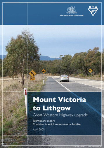
Mount Victoriato LithgowGreat Western Highway upgradeSubmissions reportCorridors in which routes may be feasibleApril 2009RTA/Pub. 09.099ISBN 9781921598340
Table of contents1. Introduction and background1.1.Corridor investigations2. Consultation activities2.1.2.2.112Consultation prior todisplay of corridors2Public display of corridors23. Submissions63.1.Context63.2.Overview of issues raised73.3.Common issues84. Next steps4.1.Where we are up toAppendix – Summary ofsubmissions received181920
1. Introduction and backgroundThe Roads and Traffic Authority (RTA) thanks everyone who contributed feedback on the MountVictoria to Lithgow Great Western Highway upgrade corridor display.Community involvement is an essential part of the planning for this upgrade.Feedback received from the community has been provided to the project team and will be usedto assist in the development of route options and the preferred route.1.1. Corridor investigationsThe Federal and NSW Governments, together with the community, are investigating an areabetween Mount Victoria and Lithgow to determine the preferred alignment for an upgrade of theGreat Western Highway.A highway upgrade would: Improve road safety. Improve road freight efficiency. Cater for the mix of through, local and tourist traffic. Be sensitive to the area’s natural environment, heritage and local communities.Mount Victoria to Lithgow study areaThe RTA engaged Sinclair Knight Merz (SKM) to undertake preliminary environmentalinvestigations to assist in the development of a preferred route for the proposed Great WesternHighway upgrade between Mount Victoria and Lithgow. The preliminary environmentalinvestigations comprise three broad phases: study area, corridor and route optioninvestigations. The preliminary environmental investigations and community consultation wereinitiated in June 2008. The study area investigations were based on a review of existing dataand desktop research, with the input of stakeholders and the community.Strategic review of a Newnes Plateau corridorThe strategic review of a Newnes Plateau corridor was commissioned in response to requestsby some members of the community to examine whether a route through the Newnes Plateauarea was feasible. RTA engaged Cardno to undertake the review. The study focused oncollating known environmental and land use constraints, testing if a route could be built toagreed road standards, and examining data relating to current and future traffic.Display of corridor investigationsFollowing completion of both studies, five corridors, in which route options may be feasible,were placed on public display from Monday 17 November 2008 to Friday 30 January 2009 atthe locations detailed in section 2.2.Stakeholders and the community were invited to comment on the corridors through a number ofconsultation activities outlined in section 2.More information about the project is available from the RTA’s website at www.rta.nsw.gov.au.Mount Victoria to Lithgow Great Western Highway upgrade – Submissions reportCorridors in which routes may be feasibleApril 20091
2. Consultation activities2.1. Consultation prior to display of corridorsConsultation with local communities and government agencies began in June 2008 with the aimof: Informing stakeholders about the highway upgrade. Identifying environmental and community issues for consideration during the study areainvestigations. Giving the community the opportunity to have input into the route development process.The following community consultation activities took place prior to public display of the corridors: Distribution of a community update in May 2008 and August 2008 to more than 12,000residents in Blackheath, Katoomba, Mount Victoria, Lithgow, Hampton, Jenolan, LittleHartley, Hartley Vale, Oberon, Newnes, Clarence, Dargan, Marrangaroo and Bell. Advertisements in local newspapers from May to August 2008 to provide information aboutthe project and upcoming community meetings. Four community meetings and four staffed displays during June 2008 at Hartley, HartleyVale, Mount Victoria and Lithgow to introduce the project and receive initial feedback. A community meeting in July 2008 at Mount Victoria to introduce the Newnes Plateaualternative corridor study and to discuss the Central West Transport Needs study. Four community workshops in August 2008 at Mount Victoria and Hartley to help identifyproject constraints. Distribution of householder letters in July 2008 and October 2008 to provide updates to morethan 12,000 residents in Blackheath, Katoomba, Mount Victoria, Lithgow, Hampton, Jenolan,Little Hartley, Hartley Vale, Oberon, Newnes, Clarence, Dargan, Marrangaroo and Bell. Meetings and briefings from March to July 2008 with various government agencies, localcouncils and associations. Information sessions in June 2008 and August 2008 with local Aboriginal communities. A stakeholder and community workshop at Lithgow in September 2008 to discuss projectconstraints relating to the Newnes Plateau alternative corridor. Media releases in August 2008 and October 2008. Provision of a dedicated project information toll free number, email address and website todistribute information and receive feedback. A project database to record all community discussions.2.2. Public display of corridors2.2.1. Display locationsThe five corridors were placed on display for comment from Monday 17 November 2008 toFriday 30 January 2009. During this time, hard copies of the reports and posters of the corridorswere on display at the following locations:Mount Victoria to Lithgow Great Western Highway upgrade – Submissions reportCorridors in which routes may be feasibleApril 20092
Blue Mountains City Council. Katoomba Library. Lithgow City Council. Lithgow Library. Oberon Shire Council.Information was also available on the RTA’s project website.2.2.2. Consultation to support display periodThe following consultation activities were undertaken to advise the community and stakeholdersof the corridors display: Distribution of a community update in November 2008 outlining the key findings of the twostudies to more than 12,000 residents in Blackheath, Katoomba, Mount Victoria, Lithgow,Hampton, Jenolan, Little Hartley, Hartley Vale, Oberon, Newnes, Clarence, Dargan,Marrangaroo and Bell. Letters to more than 650 landowners in the study areas. Direct mail to approximately 150 stakeholders, including local councils, governmentagencies and local community groups enclosing copies of the Study area investigations andcorridors identifications report and the Strategic review of a Newnes Plateau corridor report. Email notification to stakeholders in the project database advising of updated informationavailable on the project website. Advertisements during November 2008 in the Blue Mountains Gazette, Lithgow Mercury,Oberon Review, The Land, Sydney Morning Herald, Daily Telegraph, The Koori Mail andThe National Indigenous Times to advise the community about upcoming meetings,workshops and displays. Online recording of the Newnes Plateau corridor presentation. Media release in November 2008. Provision of a dedicated project information toll free number, email address and website todistribute information and receive feedback. An additional 26 CD copies of the two November 2008 reports to individuals (followingrequests).2.2.3. Community meetings, workshops and displaysFive community meetings, five workshops and seven staffed displays were held during thedisplay period to provide the community with opportunities to attend sessions and providefeedback. Details of each of these events are set out in the tables below.The purpose of the sessions was to give the community the opportunity to view the corridors,speak to members of the project team and provide feedback on the corridors. Attendees werealso able to view panels displaying the corridors and hard copies of the reports.Issues and comments raised by participants at these events were recorded by the study teamand have been included in the project database. In particular, comments made during theworkshops relating to particular areas or items on maps have been used by the project teamwhen deciding the final corridors.Mount Victoria to Lithgow Great Western Highway upgrade – Submissions reportCorridors in which routes may be feasibleApril 20093
Table 2-1 Community meetingsEventDate and locationAttendanceCommunitymeetingMonday 24 November, 6.30pm to 8pmFatima Hall, 1102 Great Western Highway, Lithgow60CommunitymeetingTuesday 25 November, 6.30pm to 8pmMount Victoria Public School, Great Western Highway,Mount Victoria125CommunitymeetingWednesday 26 November, noon to 2pmHartley school building, corner Great Western Highwayand Mid Hartley Road, Hartley69CommunitymeetingWednesday 26 November, 6.30pm to 8pmHartley school building, corner Great Western Highwayand Mid Hartley Road, Hartley81CommunitymeetingThursday 27 November, 6.30pm to 8pmDargan/Clarence Fire Shed, Chifey Road, Clarence32Aboriginalcommunity meetingSaturday 29 November, 9am to noon Lithgow RegionalLibrary, 157 Main Street, Lithgow7Aboriginalcommunity meetingFriday 12 December, 10am to noonBlue Mountains Aboriginal Cultural Resource CentreKatoomba, 14 Oak Street, Katoomba8Table 2-2 Community workshopsEventDate and locationAttendanceWorkshopTuesday 2 December, 6.30pm to 8.30pmMount Victoria Public School, Great Western Highway,Mount Victoria35WorkshopWednesday 3 December, noon to 2pmHartley school building, corner Mid Hartley Road andGreat Western Highway, Hartley25WorkshopWednesday 3 December, 6.30pm to 8.30pmUnion Theatre, 63-65 Bridge Street, Lithgow12WorkshopThursday 4 December, 6.30pm to 8.30pmDargan/Clarence fire shed, Chifley Road, Clarence13WorkshopSaturday 6 December, 2pm to 4pmHartley school building, corner Mid Hartley Road andGreat Western Highway, Hartley20Table 2-3 Staffed information displaysEventDate and locationApproximateattendanceStaffed displaySaturday 29 November, 10am to 2pmComet Inn, Hartley Vale Road, Hartley Vale16Staffed displaySaturday 29 November, 9am to noonLithgow Regional Library, 157 Main Street, Lithgow23Staffed displaySaturday 6 December, 9am to noonLithgow Golf Club, Great Western Highway, Lithgow23Staffed displayTuesday 9 December, 2pm to 6pmHartley school building, corner Mid Hartley Road and3Mount Victoria to Lithgow Great Western Highway upgrade – Submissions reportCorridors in which routes may be feasibleApril 20094
EventDate and locationApproximateattendanceGreat Western Highway, HartleyStaffed displayWednesday 10 December, 2pm to 6pmDargan/Clarence fire shed, Chifley Road, Clarence12Staffed displayThursday 11 December, 2pm to 6pmRTA Motor Registry, Valley Plaza Shopping Centre,corner Lithgow and Bent Streets, Lithgow3Staffed displaySaturday 13 December, 10am to 2pmHartley school building, corner Mid Hartley Road andGreat Western Highway, Hartley2Mount Victoria to Lithgow Great Western Highway upgrade – Submissions reportCorridors in which routes may be feasibleApril 20095
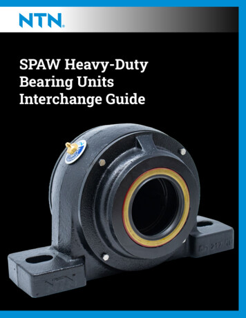
3. Submissions3.1. ContextA total of 462 submissions were received in response to the corridors display. Submissionswere received via a dedicated feedback form, through the project email address or by post. Ofthe 462 submissions received, 437 were received from individuals and 25 from governmentagencies, local councils, environment and conservations groups, other organisations, orresident and local community groups.Of the 437 individual submissions received, 333 submissions were from individuals whosubmitted a proforma email in support of the Newnes Plateau corridor.Figure 3-1 Submissions by stakeholder groupFigure 3-2 Submission typeMount Victoria to Lithgow Great Western Highway upgrade – Submissions reportCorridors in which routes may be feasibleApril 20096
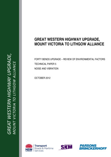
Figure 3-3 Submissions by stakeholder location333 submissions were generated using the Hartley Highway Action Group’s website. No addresses were provided withthese emails so no stakeholder location has been assigned in the above figure 3-3. These submissions, however, werecarefully considered by the project team along with all other feedback.3.2. Overview of issues raisedEach submission was reviewed individually, assigned a reference number, and provided to RTAand its consultants for review. At the Appendix we provide a record of the submissions receivedand the issues raised.Issues were sorted under the following broad categories.Table 3-1 Description of categoriesCategoryDescriptionClimate changeCarbon emissions.CostFunding.Economic impactsImpact on business.EngineeringRoute and design options, road safety, local access, terrain,weather, traffic mix.Environment and ecologyRare and endangered species, ecological communities,hydrology.HeritageAboriginal and non Aboriginal items and places.ProcessConsultation activities.PropertyImpact on property values and acquisition.Social impactsAesthetics, noise and visual pollution, amenity, severance,character, ambience.Transport planningTraffic modelling.GeneralComments in support or opposition for particular corridors.Proforma letter - support forNewnes corridorReflects the 333 proforma emails received in support of thiscorridor option.Mount Victoria to Lithgow Great Western Highway upgrade – Submissions reportCorridors in which routes may be feasibleApril 20097
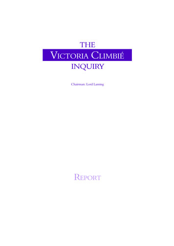
The main issues raised by stakeholders focussed on: The need to protect areas of environmental significance (particularly threatened andendangered flora and fauna). Engineering and design options (including alternatives such as tunnels). Loss of amenity and severance. Traffic modelling (particularly movement of B-doubles). Whether the commitment to bypass Mount Victoria would be honoured. The extent of heritage items in the study area.The diagram below shows the number of comments made against each category.Fig 3-4 Number of comments against categoriesProforma letter - support Newnes corridorEnvironment/ecologyEngineeringSocial impactsTransport planningProcessHeritageCostEconomic ImpactsGeneralPropertyClimate change050100150200250300350Number of commentsNote: the ‘General’ category includes comments that reflect both support and opposition for various corridors.3.3. Common issuesThe most common issues raised in the submissions are set out below. A full summary of issuesraised is provided at the Appendix.Proforma email in support of Newnes Plateau corridorA large proportion of stakeholders supported the Newnes Plateau corridor option.More than 300 emails were received that stated, “I support the proposed northern route tobypass Mt Victoria & Lithgow. This route is currently being investigated by RTA and itsconsultants along the line drawn on www.hhag.com.au. This route avoids any disruption tohistoric Hartley Valley”.CommentThe RTA is no longer considering an upgrade using the Newnes Plateau corridor. TheMount Victoria to Lithgow Great Western Highway upgrade – Submissions reportCorridors in which routes may be feasibleApril 20098
Department of Defence has indicated it has a long term commitment to the Marrangaroo ArmyBase that provides essential facilities. This 1338 hectare site area covers the entire width ofthe blue corridor. This base is used for training specialist personnel and disposing ofammunition. Defence is very clear in its response to the corridors that a highway would not becompatible to its activities on the base.The RTA must make decisions based on the issues and feasibility of options. We appreciatethere was support for the Newnes Plateau corridor within the submissions received.TunnelA considerable number of submissions made suggestions on possible route design options, inparticular a 4km tunnel to be constructed under Mount Victoria from Brown Town Oval,travelling to Little Hartley. Comments suggested that a tunnel would: Effectively bypass the village of Mount Victoria. Mean no new impacts on the Bell, Dargan, Newnes and Clarence communities from theNewnes Plateau option, or on the Hartley Vale community from the three other corridors. Avoid major impacts on wildlife corridors and on conservation areas, including the GreaterBlue Mountains World Heritage Area. Cost considerably less than the 900m Newnes option. Mean no adverse impacts on tourism and recreational opportunities associated with all thenew corridors. Lower the construction costs by avoiding some of the difficult terrain faced by all corridoroptions, and would maximise the use of the existing highway in Hartley. Mean that Newnes Plateau native vegetation would not be bulldozed and cleared duringconstruction.CommentWhile a long tunnel is unlikely to be cost effective, shorter tunnels may be considered to meetproject objectives. The RTA is investigating a tunnel under Mount York Road as part of anoption to bypass Mount Victoria.GradesThere were some concerns about whether any of the corridors that passed through the HartleyValley could meet the RTA’s desired grade of 6%. A tunnel was thought to be a good solution inachieving a grade of less than 6%.CommentThe RTA’s preliminary investigations have indicated that grades of 6% are achievable in all ofthe four confirmed corridors. Grades would be further examined at the route development phaseof the project.HeritageThere was considerable concern about protecting heritage items (both Aboriginal and nonAboriginal) within the study area should route options be identified within all corridors. Commonheritage items that were mentioned included: Aboriginal walking tracks in the Newnes Plateau.Mount Victoria to Lithgow Great Western Highway upgrade – Submissions reportCorridors in which routes may be feasibleApril 20099
Historic roads such as Berghofers Pass, Coxs Pass, Lockyers Pass, Lawsons Long Alley,Lawsons Pass and historic Bells Line of Road. Historic buildings in Little Hartley. Convict stockade and soldiers barracks at Hassans Wall. Historic buildings in Mount Victoria. Historic remnants of shale mining in Hartley Vale. Historic railway artefacts and areas near or within the Newnes corridor.CommentThe density and significance of the heritage items within the study area is acknowledged andreported in the Study Area Investigations and Corridor Identification report (RTA 2008). Heritageis an important consideration in the development of the proposed upgrade and further heritageinvestigations will be undertaken as the preliminary environmental investigations progress.These investigations will assist with development of feasible route options, which will aim toavoid any potential impacts on items of heritage significance. Where impacts on heritage cannotbe avoided, mitigation measures aimed at minimising the impacts upon heritage items would bedeveloped following the selection of the preferred route. These considerations will be reportedon as the project proceeds.EnvironmentMany submissions included details about rare and endangered ecological communities, as wellas emphasising the environmental significance of the Newnes Plateau area. There were alsofears that all five corridors could encroach and have substantial indirect impacts on the BlueMountains World Heritage Area.Specific concerns about the flora, fauna, ecological communities and natural formations withinthe study area included potential adverse impacts on: Sensitive hanging swamps along the Darling Causeway. Unique sandstone rock formations (known as Gardens of Stone), heaths and shrub swampswithin the Newnes Plateau. There was considerable concern that highway constructionthrough Newnes Plateau could prevent the area from being incorporated into a futurenational park. Endangered species habitat in the red and green corridors such as the Copperwing butterflyand the Spotted quoll. Hyde Park on the River Lett. Wildlife corridors in all corridors. Water catchment areas, particularly in the Newnes corridor.Some submissions considered that the Study area investigations and corridor identificationreport did not adequately list all the endangered, threatened and unique species and ecologicalcommunities that exist in the Newnes corridor.CommentBiodiversity is an important consideration in the investigations and was assessed in the MountVictoria to Lithgow study area investigations and corridor identification report (RTA 2008). Asthe preliminary environmental investigations progress, further biodiversity investigations will beundertaken, with a focus on threatened species, endangered ecological communities, wildlifecorridors and native vegetation. This information will assist in the development of feasible routeoptions, which will aim to minimise impacts on areas of ecological significance. The preferredMount Victoria to Lithgow Great Western Highway upgrade – Submissions reportCorridors in which routes may be feasibleApril 200910
route would be based on a balanced consideration of all the variables.The information in the report reflects existing information held in databases and other reports.The mapping that illustrates the distribution of vegetation communities and endangeredecological communities in the study area is from a report previously prepared for theDepartment of Environment and Climate Change. Future phases of the project will involve usingmore detailed database information for mapping in the corridors, followed by field investigationsto ground-truth the information. This will include the identification of endangered ecologicalcommunities. These considerations will be reported on as the project proceeds.Social impactsThere were concerns that a highway upgrade would have adverse impacts on the socialcohesion of Mount Victoria and Little Hartley.Many community members were also concerned about the potential impacts on the amenity ofthe existing environment including visual aspects, noise, character and ambience and localaccess.One concern was that a highway upgrade would result in increased noise from passingvehicles, especially trucks.Issues were also raised about loss of tourism and recreational opportunities as a result of thehighway upgrade, particularly in the Newnes Plateau area.A number of submissions expressed concern about adverse impacts to residents in Bell,Dargan, Clarence, Newnes Junction and Marrangaroo, especially the inconvenience caused byany construction works if the proposed corridors between Mount Victoria and Bell went ahead,and the increase in noise and traffic.CommentThe RTA recognises that the visual environment and landscape associated with MountVictoria/Mount York and the Hartley Valley is unique and of high value. The urban design andlandscape assessment undertaken to date acknowledges that it is important to protect thisenvironment, to ensure that the upgrade reinforces the visual features of the area, and to usethe opportunity to enhance the road user's experience of driving through this area.The local amenity and character of the valley have been identified as a key community valuethat is important to the residents of the study area. Community values will be used as a basis forinput into the development and selection process for the preferred route and will continue to beassessed as part of the socio-economic investigations.Further socio-economic, urban design, landscape and noise assessment will be undertaken aspart of the highway upgrade investigations.Adverse weather conditionsMany questions were asked as to how the RTA would address black ice, severe frost, fogs andsnow particularly at the Forty Bends section of the highway under Hassans Walls.CommentThe issue of adverse weather conditions is being assessed and considered as part of the routedevelopment process. The RTA has engaged the Australian Road Research Board toundertake a study into the implications of black ice and frost on the proposed upgrade and toidentify potential mitigation measures to address this issue. The results of this study will be aninput to the selection of a preferred route and will be made publicly available when finalised.Mount Victoria to Lithgow Great Western Highway upgrade – Submissions reportCorridors in which routes may be feasibleApril 200911
Road safetyThe importance of improving the safety of the highway was emphasised in a number ofsubmissions, especially at Forty Bends, River Lett Hill and Victoria Pass.There were also submissions regarding the safe crossing of the highway for school children atMount Victoria.A number of submissions also raised the issue of safe access to private properties locateddirectly on the highway particularly if there were to be an increase in traffic, especially heavyvehicles.CommentThe RTA recognises the need to address the accident history in this area, with one of theprimary project objectives being to improve road safety. All of the four confirmed corridorswould provide benefits in this respect. All of these corridors would also bypass the village ofMount Victoria, which would be anticipated to remove the main conflicts between local andthrough traffic and provide safer crossing opportunities for school children.Safety improvements for private property access would be addressed as part of the conceptdesign for the preferred route, but would typically involve a reduced number of direct accesspoints to the highway, rationalised intersections and improved sight distances for safer turningmovements in and out of properties. Appropriate access arrangements would be developed inconsultation with landowners.Engineering riskA number of comments were made about the waterlogged or swampy soil conditions in theHartley Valley and whether the RTA had adequately taken into account the fill and engineeringrequired to manage this.Comments were also made about construction and cost issues in relation to mine subsidenceand old coal and shale oil workings.CommentAs the preliminary environmental investigations progress, hydrological and geotechnicalinvestigations will be undertaken to inform the development of feasible route options andminimise the engineering risk associated with construction on wet soils and historic coal andshale oil workings. The hydrological and geotechnical investigations will also assist in providingcost estimates for the feasible route options.ProcessThe main submissions relating to process were concerned with the bypass of Mount Victoria.Many people were unclear as to the RTA’s commitment to bypass Mount Victoria given that theorange and red corridors were part of the study. Questions were also asked as to how the RTAwould actually bypass Mount Victoria and asked for more detail than that provided in theNovember 2008 community update.Some submissions asked how the orange corridor met the project objectives relating to thebypass of Victoria Pass and Forty Bends.There were also questions about the consistency of the SKM and Cardno studies, including theplanning software used and the method of assessment.Mount Victoria to Lithgow Great Western Highway upgrade – Submissions reportCorridors in which routes may be feasibleApril 200912
Many people were concerned about the timeframes for selecting a preferred route and wantedclarification on whether the RTA, the Minister or the Australian Government would make thefinal decision.CommentAll four confirmed corridors would bypass the township of Mount Victoria, River Lett Hill, andreplace the steep grades at Victoria Pass. Further detail as to how this would be achieved isprovided in the April 2009 community update or on the project website at www.rta.nsw.gov.au.The Cardno and SKM reports had differences because the two investigations had differentobjectives. The objective of the Cardno study was to report on the feasibility of a NewnesPlateau corridor. The objective of the SKM study was to identify key environmental constraintsin the initial Hartley Valley study area. Further environmental studies are proposed as part ofthe route development stage for all corridors.The timeframe for the selection of a preferred route reflects the community consultation,technical investigation and design effort required for a project of this magnitude. The NSWMinister for Roads would make the decision on the preferred route based on a recommendationby the RTA.Central West Transport Needs studyMany community members were keen to learn the findings of the Central West Transport Needsstudy and were concerned the RTA was continuing with the Mount Victoria to Lithgow upgradeproject before the study is finalised.CommentThe Central West Transport Needs study was commissioned as a strategic assessment oftransport needs for the whole of the NSW Central West. Councils have received draft finalreport presentations.The Cardno investigations for the Newnes Plateau corridor study used the same traffic andpopulation growth assumptions as the Central West Transport Needs study. The findings of thetransport needs study will be considered as the Mount Victoria to Lithgow investigationscontinue.Transport issuesA large number of submissions objected to any increase in heavy vehicle movements in theBlue Mountains and opposed the removal of the restriction of 26m B-doubles across themountains.Many submissions discussed the approach to freight movements in the mountains. A number ofcomments suggested that the rail network should be improved and that any funding earmarkedfor a highway upgrade should be allocated to improving rail instead.A number of submissions considered that insufficient traffic modelling and projections had beenundertaken. There was concern that the corridor options utilising the Darling Causeway wouldmean that a large amount of extra traffic would divert to the Bells Line of Road, which alreadyhas a high accident rate. Many submissions stated that the travel time savings for the Newnescorridor option were not sufficient to attract traffic away from Mount Victoria and the existingGreat Western Highway. These submissions requested that similar investigations to thatundertaken by Cardno for the New
Hartley school building, corner Mid Hartley Road and Great Western Highway, Hartley 25 Workshop Wednesday 3 December, 6.30pm to 8.30pm Union Theatre, 63-65 Bridge Street, Lithgow 12 Workshop Thursday 4 December, 6.30pm to 8.30pm Dargan/Clarence fire shed, Chifley Road, Clarence 13 Workshop Saturday 6 December, 2pm to 4pm