Transcription
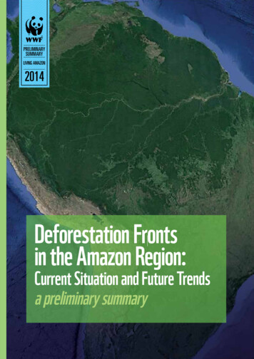
preliminaryprprelelimmiinnanararr y summarysummsummarar yPRELIMINARYSUMMARYLIVING AMAZON2014Deforestation Frontsin the Amazon Region:Current Situation and Future Trendsa preliminary summaryDeforestationDefoDeefoorestresstatiot atiotion FrontsttioFrF onts inn thehe AmazonAmaAmazmama onn Region:Regioe n: CurrentegiC urreurrent SituationurrSituaSituatuatuationuationtioiono andn FutureFuFutFutt uuurere TrendsTrendsd p.p. 1
preliminary summaryDeforestation Frontsin the Amazon Region:Current Situation and Future Trendsa preliminary summaryWWF Living Amazon Initiative
WWF Living Amazon Initiative (LAI)Claudio Maretti, LeaderAndre Silva Dias, Head Curb Deforestation andEnable Forest Economy StrategySandra Charity, Head of Programme DevelopmentKaren Lawrence (WWF UK), Science Monitoring SupportDenise Oliveira, Head of CommunicationsDeforestation Fronts in the Amazon Region:Current Situation and Future Trendsa preliminary summaryWWFAndre da Silva Dias, Claudio Maretti, Karen Lawrence,Sandra Charity, Denise OliveiraConsultants:James Johnson, Luis Humberto Gomez Cerveró, Gustavo Accacio,Guilherme AbdalaCover photo@ Google earthMapsWWF Brasil/Landscape Ecology LaboratoryLayoutSupernova DesignContacts:LivingAmazon@wwf.org.br 55 61 3364.7497www.panda.org/amazonDecember 2014
preliminary summaryDEFORESTATION FRONTS IN THE AMAZON REGION:CURRENT SITUATION AND FUTURE TRENDS - A PRELIMINARY SUMMARYCONTENTINTRODUCTION06MAIN RESULTS08FUTURE TRENDS OF DEFORESTATION10CONCLUSIONS11RECOMMENDATIONS12ANNEX I17Deforestation Fronts in the Amazon Region: Current Situation and Future Trends p. 5
Deforestation Fronts in the Amazon Region: Current Situation and Future TrendsINTRODUCTIONThis preliminary summary highlights some of the preliminary findings of the‘Deforestation Fronts in the Amazon Region: Current Situation and Future Trends’report, part of the LAI’s ‘State of the Amazon’ report series. The summary describesthe change in the dynamics of deforestation across the Amazon region over the period2001-2012, namely a significant decline in the rate of deforestation in the BrazilianAmazon but increasing rates of deforestation in the Andean Amazon countries.The Amazon is a complex natural region, comprised by an array of interdependentecosystems (what happens in some of its parts affects the others), and hugelyimportant in terms of the ecosystem services it provides, including ecologicalprocesses, biodiversity and cultural diversity.However, it is a region at a crossroads: although this region is still in a relatively wellconserved and well-protected condition (one of best well-protected amongst the mostimportant natural areas on Earth), it is also under increasing degradation pressure.Therefore, either it is heading towards a large-scale, irreversible ecological disasterwith profound regional and global implications, or, if there is sufficient political will,it can take an alternative route to sustainable development in harmony with nature,retaining its crucial ecosystem services for the South American continent and theworld. The direction it takes depend on the policies and strategies adopted by thecountries that share this unique natural region.The report uses forest cover data generated by Global Forest Change 20131 supportedby the University of Maryland, additional complementary data from PRODES(INPE, 2013) for Brazil, and literature reviews. The geographic scope is the AmazonBiome, defined as the area covered predominantly by dense moist tropical forest,with relatively small inclusion of savannas, floodplain forests, grasslands, swampsbamboos and palm forest. The Biome encompasses 6.7 million km2 and is sharesby eight countries: Brazil, Bolivia, Peru, Ecuador, Colombia, Venezuela, Guyana andSuriname, and the overseas territory of French Guiana.1M. C. Hansen,*, P. V. Potapov, R. Moore, M. Hancher, S. A. Turubanova, A. Tyukavina1, D. Thau, S. V. Stehman, S. J.Goetz4, T. R. Loveland, A. Kommareddy, A. Egorov, L. Chini1, C. O. Justice, J. R. G. Townshend (2013) High-ResolutionGlobal Maps of 21st-Century Forest Cover Change. Science 15 November 2013: Vol. 342 no. 6160 pp. 850-853 DOI: 10.1126/science.1244693Deforestation Fronts in the Amazon Region: Current Situation and Future Trends p. 6
preliminary summaryFigure 1 – Deforestation fronts in Amazon Biome in 2012.MAIN RESULTSa) Amazon deforestation is shifting towards the Amazon-Andeancountries: during the period 2001-2012, Brazil was responsible on average for75% of deforested area in the Amazon biome, followed by Peru (8%), Bolivia (7%),Colombia (6%) and Ecuador (1%). Venezuela, Guyana, Suriname and French Guianatotal is 3%. This means that Brazil, Bolivia and Peru account for 90% of deforestationin the Amazon during the 12 years period.The first period (2001-2006) has a slightly higher cumulative deforestation area (62,5%)than the second period (2007-2012) (Figure 2). This decline is due principally to the sharpreduction in deforestation in the Brazilian Amazon region, which by 2012 had fallen to lessthan 1/5 of its 2004-2005 levels (from over 25,000 km2 to less than 5,000 km2).However, the gains obtained in Brazil have been partially offset by the increased rateof deforestation in the Andean Amazon countries. While in 2001 Brazil’s deforestationrepresented 81% of total deforestation in the Biome, in 2012 it had dropped to 44%(Figure 3). However, in total surface area, this still amounts to vast areas of forestloss. Moreover, the Brazilian case, despite being the most important result globally,might have tackled the easier part, needing now a good revision to continue curbingthe deforestation.Deforestation Fronts in the Amazon Region: Current Situation and Future Trends p. 7
Deforestation Fronts in the Amazon Region: Current Situation and Future Trends25000Deforestation 007200820092010201120122009201020112012Figure 2 – Total deforestation in Amazon Biome 2001-201225000Deforestation l200620072008Other countriesFigure 3 – Contribution of Brazil and other countries to total deforestation in the Amazon Biome from 2001-2012.Deforestation Fronts in the Amazon Region: Current Situation and Future Trends p. 8
preliminary summaryb) We identify 25 active deforestation fronts in the Amazon regions(Table 1 - Annex) of Brazil, Bolivia, Peru, Colombia and Ecuador and their respectiveunderlying causes and determining drivers of forest loss (number 1 to 25 in Figure 1).There are 9 deforestation fronts with increased deforestation trends (1 in Brazil, 3 inEcuador, 3 in Peru and 2 in Bolivia), 8 additional fronts with decreased deforestationtrends (6 in Brazil and 2 in Bolivia) and 8 fronts with fairly steady deforestation rates(4 in Brazil, 1 in Peru and 3 in Colombia).c) Among them, there are three large-scale cross border deforestationfronts, two of which appear to be heading to reduced deforestation rates (Brazil/Bolivia and Brazil/Peru/Bolivia) and one other with a fairly steady rate (Colombia/Ecuador/Peru): The border between the Brazilian state of Rondonia and Bolivia (number 9); The western Amazon region connecting Brazil, Peru and Bolivia along theInteroceanic Highway (number 10); The tri-national border between Peru, Colombia and Ecuador along the Putumayoriver (number 23). Northern Rondônia state (Brazil) and Northeastern Bolivia (front # 9): colonization began with the construction of a Brazilian road, connecting the Brazilianstates of Rondonia and Mato Grosso with the industrial south of the country. Onthe Brazilian side of the border deforestation is caused predominantly by colonistfarmers, resulting in the well-known ‘fishbone’ settlement pattern. The trend inthis front is of reduced deforestation. However, the analysis of cumulative deforestation shows that this is the third most extensive deforestation front in theAmazon over the past 12 years, with a cumulative deforested area of 16,053 km2and an average annual deforestation rate of 1,337 km2/yr during the period. Acre state (Brazil), Cobija (Bolivia) and Puerto Maldonado (Peru) (front # 10):road infrastructure development has been the main underlying cause of deforestation in this cross border area of Brazil, Bolivia and Peru, with cattle ranchingand spontaneous colonization as determining drivers. This front has a relativelystable reduction rate of deforestation, which peaked in 2005, and currently has acumulative deforested area of 8.552 km2 (average annual deforestation about 500km2/yr). Putumayo (Peru, Ecuador, Colombia), Caqueta (Colombia) and San Pedro (Ecuador) North (front # 23): the area located along the river Putumayo forms part ofa larger deforestation front, which continues across the border into Ecuadorianand Peruvian territory. Settlements (vicinity of the rivers Caguan, Orteguaza,Caquetá and Putumayo), development of access roads in the sub-Andean foothills and oil exploration have been the main underlying causes of deforestationin this cross border area, with slash and burn agriculture; illicit crops and cattleranching as determining drivers. This front has the highest cumulative deforestation in Colombia and Ecuador (7,349 km2), and an average annual deforestationof 612 km2/year. Deforestation is variable between years and the trend is stablearound the average. Beside those 25 active deforestation fronts, there are three more considered to beconsolidated fronts where further deforestation is limited within existing areasrather than expansion into new areas. These consolidated areas are largely located in the Arc of Deforestation in Brazil (A, B and C in Figure 1), which spreadsDeforestation Fronts in the Amazon Region: Current Situation and Future Trends p. 9
Deforestation Fronts in the Amazon Region: Current Situation and Future Trendsfrom eastern Pará state to the centre of Rondonia passing through northern MatoGrosso which experienced the accelerated rates of deforestation witnessed overthe previous decade. Deforestation in the Amazon is increasingly a global affair and is driven mostly by global factors that have become incorporated into regional and nationaldevelopment plans. The drivers are essentially the same in nature across theAmazon (Table 1 - Annex), but different in their importance in each case, It isalso important to mention that there are interaction among those drivers, suchas, for instance, plantations and roads, or cattle ranching and land speculation,dams and roads, etcFUTURE TRENDS OF DEFORESTATIONWe studied the occurrence of different threats in each of the deforestation frontanalyzed, (such as presence of roads, oil and gas exploration, extraction activities,mining, hydroelectric dams and fires). The fronts showing the greatest deforestationrates are areas with more roads, showing a strong correlation between deforestationand the presence of roads and projections of new roads. Similar results have beenpredicted for the Amazon region in the “Amazon Under Pressure” report2.Most of the 25 deforestation fronts identified show a tendency for increased or steadydeforestation, diffusing the deforestation in the region, in contrast with the historicexpanding Brazil’s so-called “arc of deforestation”. This diffusion goes westwardstowards the Amazon-Andean slopes. Another broad front is developing in the upperreaches of the Amazon basin in Peru, Colombia and Ecuador, and a third front inestablishing itself in the region north of Manaus.Besides, there probably is more border crosscutting driving elements, close to theborder and far from them, such as the increase of cattle ranching and soy plantationsin Bolivia, going towards the Amazon, and linked to the Brazilian markets. Also,started with banks and a group of country governments, the South American energyand transport integration is a key element related to the deforestation pattern. Similarapproach could be mentioned by hydropower dams in other countries related to theBrazilian markets (consumption, funding, building capacity). Oil in the AndeanAmazon countries also responds to broader demands. This is the other side of theinterdependence of the Amazon parts, related to the deforestation drivers, linkedinternationally, including to finance sector.Although this assessment only analysed the data of the years 2001-2012, consideringthe bibliography, the systematic Brazilian deforestation data and doing some nonrigorous extrapolation, we find that something at the scale of 25 to 30% of theAmazon forest could be gone by 2030. Another similar area is going to be probably innot so good conservation standards due to several forest degradation processes. Somescientific assessments consider that 30-40% of deforestation and forest degradationcould dangerously approach to a possible turning point which could lead the Amazonto a further degradation cycle. Considering the vital role of the Amazon in the rainfallregime of the continent and the crucial global climate importance of avoiding itscarbon to be emitted.2RAISG. 2012. Amazonía bajo presión. www.raisg.socioambiental.orgDeforestation Fronts in the Amazon Region: Current Situation and Future Trends p. 10
preliminary summaryCONCLUSIONSAlthough over the last decade there has been an important reduction in therate of deforestation across parts of the Amazon region, deforestation andforest degradation in the region continues at an alarming rate. This pictureleaves little room for optimism in the longer term, with rates of deforestation increasingin some countries and new roads being opened up in hitherto unaffected areas.Brazil continues to be responsible for about 50% of deforestation in the Amazon,although the rate of deforestation in the last decade has declined significantly. Onthe other hand, there is a general trend for deforestation to increase in theAndean Amazon countries, with Bolivia and Peru showing marked tendenciesto increase, more so if we consider not the absolute figures (in hectares or so), but inrelative terms to their own share of the Amazon.Combating deforestation in the region is no longer the task of isolatednational policies; it is essential to have integrated policies and anarticulated action that seeks to value the standing forest throughout thebiome. There are some cross-border deforestation fronts such as the deforestationtaking place in the northwest of Brazil and the northeast of Bolivia, or along thefrontier between Peru and Colombia, or on the triple frontier of Brazil, Peru andBolivia, all of which are driven by actions that are entirely uncoordinated among thecountries.Furthermore, the Amazon functions as a single ecological unit and has a complexsystem of interactions between its highly inter-dependent parts; destabilising onepart has impacts on other parts. Amazon deforestation is no longer an issue forindividual countries to tackle in isolation from other countries. Many drivers areglobal, and impacts that appear to be localised are felt in other partsof the biome, and often well beyond its boundaries, as such the role of theAmazon forest keeping moist air moving, leading to rainfall in mainland areas,distant from the oceans3.Although many drivers of deforestation across the Amazon region share commoncharacteristics, the relative importance and the specific nature of these driversvaries both within and between countries. The direct drivers of deforestationare predominantly extensive cattle ranching, land speculation and large-scalemechanized agriculture (mainly soybeans), and complemented to a lesser extentthe illicit crops and small scale subsistence farming. The following factors, alsosignificant, have both direct and indirect impacts on deforestation: oil and naturalgas exploration; construction of hydroelectric dams, roads, mining and other majorinfrastructure development projects. More important than separating thedrivers, is the understanding of the relationship among them and themultiplication effects of their combination. Access, particularly through roaddevelopment, is identified as the single most important underlying factor leading todeforestation and is related to most of, if not all, the other drivers.3Nobre, A. 2014. El Futuro Climático de la Amazonía. Informe de Evaluación para la Articulación Regional AmazónicaDeforestation Fronts in the Amazon Region: Current Situation and Future Trends p. 11
Deforestation Fronts in the Amazon Region: Current Situation and Future TrendsThe strong correlation between the location of deforestation fronts and the presenceof existing roads or projections of new roads suggests that in the near future wecan expect to see isolated deforestation fronts becoming connected alongmajor infrastructure development routes. These fronts will then becomeaxis of deforestation unless there is a drastic change in policy or a collapse in globalcommodity prices.The process of occupation of the Amazon decades ago were motivated by governmentsconsidering the region an “empty” space to be developed and to realize the region’sproductive potential. By now, and in another scale and impact, this process isstrongly connected with international markets (agro-commodities, energy (oil andhydropower), minerals, etc.).RECOMMENDATIONSA key objective of WWF’s Living Amazon Initiative (LAI) is that “By 2020,governments of five Amazon countries develop “zero net deforestation” nationalaction plans based on an Amazon-wide regional vision, while relevant private sectorand finance institutions adopt robust environmental and social safeguards in theirlending policies and create new financial incentives to scale up sustainable foresteconomy practices”.AMAZON GOVERNMENTSTO DESIGN ANDIMPLEMENT ‘ZERONET DEFORESTATION’NATIONAL PLANSIn order to achieve this objective, WWF, through its Living Amazon Initiative (LAI),and with partners and other stakeholders, proposes to the governments, private andfinance sector to make that decision makers at regional, national and subnationallevels in government, civil society, and the private sector embrace and operationalizethe following recommendations for the Amazon Biome:1. Amazon governments to design and implement ‘zero net deforestation’national plans that take account an Amazon regional vision and specific contextsand characteristics of each deforestation front. National amazon governments to showstrong political will to make changes and sustain this position in a long term, possiblythrough the national programmes to avoid and control deforestation, integratedcross-sectorially and among Amazon countries. Weak or absent political will canreverse or dismantle the positive impacts of effective governance frameworks andincentive structures to control deforestation.2. Amazon governments to generate and disseminate information ondeforestation, with support of scientific institutions, and to createawareness in the region as a whole and at the specific country level.3. Amazon and other governments to review how incentive mechanismscan contribute to the reduction in the rate of deforestation by avoidingthe current perverse incentives that promotes activities that cause or are relatedto deforestation and by promoting economic incentives for investments in moresustainable productive activities.Deforestation Fronts in the Amazon Region: Current Situation and Future Trends p. 12
preliminary summary4. Amazon and other governments and finance and private sector topromote and actually do the sustainable forest management and use ofother ecosystems, including research to raise their value, and recognising theindigenous peoples and local communities rights, as a way to promote sustainabledevelopment and give value to the standing forests and free flowing rivers.5. Finance sector (including private, public and multilateral developmentbanks) and private sector to open themselves to dialogues with the civilsociety organizations, local communities, scientific institutions and governments toensure that new appropriate measures are taken to safeguard investments in terms oftheir potential social and environmental impacts.AMAZON GOVERNMENTSAND OTHERORGANISATIONS TOFACILITATE CROSS BORDERDIALOGUE6. Amazon governments and other organisations to facilitate cross borderdialogue between national and subnational governments, and finance and privatesectors, as well as scientific institutions, local communities and civil societyorganizations, based on the exchange of experiences and lessons learned in haltingdeforestation.7. Establish and support the establishment of different types ofconservation spaces or mechanisms, including indigenous territories, protectedareas, sustainable development reserves co-managed with local communities andother community conserved areas. All integrated with national and subnational landuse and sustainable development plans.8. Amazon governments recognise indigenous peoples and local communitiesrights and work with them to improve their management and wise use of theirlands and to publicise their important role in conservation (ecosystem services,biodiversity, carbon storage, water, etc.Deforestation Fronts in the Amazon Region: Current Situation and Future Trends p. 13
Montanhas do Tumucumaque National Park, Amapa state, Brazil
LUCIANO CANDISANI / WWF
Deforestation Fronts in the Amazon Region: Current Situation and Future TrendsANNEX ITable 1. Deforestation fronts in the Amazon Biome (2001-2012). IncreasingN1CountryBrazil DecreasingDeforestationFronts SteadyDeforestation(2001 – 2012)TransamazonicaLeste - BR-163Norte13.954Average defkm2/yr1.163Underlying CausesDetermining DriversTrendColonization policyInfrastructure Development Belo Horizonte Dam and BR163 HighwayHigh commodity pricesSoya bean expansion in areas ofbetter accessCattle ranching in areas ofpoorer accessColonization with expansion ofcocoa production 2BrazilTerra Santa-Oriximiná-Prainha3.266272Infrastructure DevelopmentColonization policyCcolonizationExtensive cattle ranching 3BrazilPará Centro-Sul10.704892Infrastructure developmentWeak control of illegal loggingColonization policyExtensive cattle ranchingSmall farmer settlement 4BrazilBR - 163 Centro7.447621High commodity pricesWeak control of illegal loggingSoya bean and extensive cattleranchingInformal gold miningDeforestation Fronts in the Amazon Region: Current Situation and Future Trends p. 16
preliminary 01 – 2012)Average defkm2/yrUnderlying CausesDetermining DriversTrend 5BrazilTransamazónicaCentro2.013168Colonization policyInfrastructure DevelopmentCattle ranchingCocoa production on small farms6BrazilManaus PresidenteFigueiredo1.884157Colonization policyInfrastructure development Balbina DamIllegal loggingSmall farmer agricultural developmentCattle ranching 7BrazilBoa Vista,Caracaraí eRorainópolis3.413284Colonization policyInfrastructure development-Perimetral Norte RoadLarge scale rice productionSmall farmer development 8BrazilMato GrossoNoroeste14.5491.212High commodity pricesFiscal policy favours large farmsectorTechnological developmentInfrastructure developmentExpansion of commercial soyaproductionLarge scale cattle ranching 9Bolivia/BrazilRondonia Norte16.0531.338Infrastructure development-roadsColonization policy; loggingFarmingCattle ranching 10Brazil/Peru/BoliviaAcre Sul PuertoMaldonado8.552713Infrastructure development Interoceanic HighwayCattle ranchingSpontaneous colonization (Bolivia and Peru) 11BrazilAcre Amazonas1.846154Road infrastructure,Colonization policyMedium scale farmingSmall scale cattle production 12BrazilRondonia Oeste3.395283Road infrastructure;Agricultural expansion policiesMedium scale farmingSmall scale cattle production 13BoliviaYucumo – Ixiamas47139Colonization policyInfrastructure developmentPromotion of a sugar refinery 14BoliviaCoroico, Caranavi, Guanay ePalos Blancos18315Cash crops productionSlash and burn agricultura 15BoliviaSanta Cruz dela Sierra11.188932Agricultural expansion policiesInfrastructure development-roadsColonization policiesExtensive commercial crops andcattle productionSlash and burn agriculture 16BoliviaChapare1.698142Colonization policyAgriculture policy, oil exploitation; loggingSmall-medium scale farming(coca; bananas, fruits); cattleranching; logging 17PeruRoute 18C-Huanuco andUcayaliInfrastructure development-roads and gas pipelineFood crops, slash and burnagriculture; small scale cattleranching and oil palm production 18PeruCarr. Marginalde la selva eCarr. F. Basadre5.843487Colonization policyInfrastructure development-roadsMiningSmall-medium scale farming(coca, banana, palm hearts);cattle ranching 19PeruCarretera 5N Amazonas26222Infrastructure development-roads and hydroelectric projectspredictFarming, illicit coca production20PeruLoreto IquitosRio Marañón18315Infrastructure development-roadsColonization policySlash and burn agriculture; cattleranching; palm oil plantations 21EcuadorPuerto Morona111Infrastructure development-access to waterwayMorona – Marañón – Amazonas; oil exploration; miningFarming, illegal logging 22EcuadorCarretera E4543036Infrastructure development-road Ruta Marginal de la SelvaFarming; small scale cattleranching; logging 23Colombia/EcuadorAltos Rios,Putumayo,Caqueta e SanPedro - Sucumbios - Orellana- Nueva Loja7.349612Opening up of oil exploration;on routes; spontaneous colonizationFarming; palm oil plantation Deforestation Fronts in the Amazon Region: Current Situation and Future Trends p. 17
Deforestation Fronts in the Amazon Region: Current Situation and Future 1 – 2012)Average defkm2/yrUnderlying CausesDetermining DriversTrend24ColombiaRio PuertoRico, S. Joséde Guaviare yCalamar1.899158Colonization policy;Infrastructure developmentroad access in the sub-Andeanfoothill; oil explorationSlash and burn agriculture; illicitcrops; cattle ranching 25ColombiaRio Baixo, RioGuaviare424Major center of activities of theRevolutionary Armed Forces ofColombia (FARC)Agriculture ABrazilPará Leste42.0123.501Colonization policy; Infrastructure development-roadsCattle ranching; mining BBrazilMato GrossoCentral46.7023.892Colonization policy and spontaneous colonizationCattle ranching; mechanizedagriculture CBrazilRondoniaCentral7.970664Colonization policy; infrastructure developmentSelective logging, cattle ranching, soya production Deforestation Fronts in the Amazon Region: Current Situation and Future Trends p. 18
DEFORESTATION FRONTS IN THE AMAZON REGION:CURRENT SITUATION AND FUTURE TRENDSA PRELIMINARY SUMMARYLIVING AMAZON INITIATIVE96.7million square kilometres isthe area of the Amazon Biomecountries share theAmazon biome (Bolivia,Brazil, Colombia, Ecuador,Guyana, Peru, Suriname,Venezuela and Francethrough its overseasterritory French Guyana)2590-140billion metric tonnes of carbon storedin the Amazon rainforestsActive deforestation fronts inthe Amazon regionLAIwww.wwf.org.br 1986 - Panda Symbol WWF “WWF” is a WWF Registered TrademarkWWF Living Amazon Initiative: SHIS EQ QL 6/8, Conjunto E – CEP 71620-430, Brasília, DF(55 61) 3364-7400PANDA.ORG/AMAZONWhy we are hereTo stop the degradation of the planet’s natural environment andto build a future in which humans live in harmony with nature.
Karen Lawrence (WWF UK), Science Monitoring Support Denise Oliveira, Head of Communications Deforestation Fronts in the Amazon Region: Current Situation and Future Trends a preliminary summary WWF Andre da Silva Dias, Claudio Maretti, Karen Lawrence, Sandra Charity, Denise Oliveira Consultants: James Johnson, Luis Humberto Gomez Cerveró .


![Index [beckassets.blob.core.windows ]](/img/66/30639857-1119689333-14.jpg)